134:
141:
319:
29:
1322:
311:
381:
The
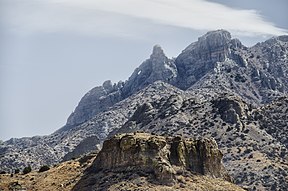
Florida Mountains are a small, compact range about 12 miles (19 km) long, with various peaks from 5,000 to 7,000 feet (1,524 to 2,134 m). The range highpoint is Florida Peak, 7,295 feet (2,224 m), which lies near the north. Other high peaks in the center-south, are Gym, Baldy, and
385:
Most of the land surrounding the prominent rise of the mountain range are flatlands. Deming, and its suburbs directly south, form the northwest and west border of the range's minor foothills. Populated flatlands are northeast, with open flatlands to the east and southeast.
528:
1281:
873:
1382:
382:
South Peak. Four other peaks are in the extreme northwest; besides
Florida Peak, the tallest of the other four is Capitol Dome, at 5,962 feet (1,817 m).
1363:
1161:
133:
1166:
964:
594:
464:
1023:
1387:
242:
773:
521:
1196:
537:
1392:
396:. The park is nestled between the Florida Mountains, and a 3-mile (5 km) long mountain range called the Little Florida Mountains.
69:
1276:
832:
817:
1356:
514:
888:
426:
1065:
1266:
898:
809:
235:
62:
1349:
1241:
1070:
969:
1291:
1221:
1181:
979:
956:
947:
1043:
1007:
992:
883:
799:
671:
421:
389:
366:
1236:
699:
362:
1301:
1156:
1151:
405:
339:
286:
198:
471:
1231:
1116:
987:
863:
653:
553:
216:
1091:
563:
228:
1146:
224:
1211:
1131:
1111:
850:
393:
291:
220:
212:
1216:
1191:
691:
645:
545:
501:
318:
1296:
997:
709:
617:
409:
370:
343:
277:
208:
28:
1271:
1251:
1121:
1106:
1057:
907:
791:
763:
599:
355:
347:
188:
1333:
1101:
1096:
925:
750:
722:
676:
609:
571:
1286:
1261:
1246:
1206:
1136:
732:
663:
310:
299:
365:, the north–south route to Chihuahua; it becomes Highway 23 in Chihuahua and connects to
1321:
1033:
717:
331:
1376:
822:
635:
1186:
1171:
1126:
1038:
933:
915:
858:
740:
681:
627:
281:
1226:
1201:
1141:
1086:
1028:
1002:
840:
781:
758:
586:
576:
1329:
1256:
335:
156:
257:
244:
84:
71:
506:
369:, the major east–west route of the north Chihuahuan Desert adjacent the
351:
52:
317:
309:
510:
445:
New Mexico Atlas & Gazetteer, DeLorme, c. 2009, p. 54-55.
314:
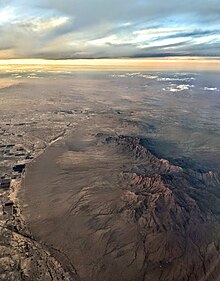
Aerial view of the
Florida Mountains and vicinity at sunset
1337:
1079:
1056:
1016:
978:
955:
946:
924:
906:
897:
872:
849:
831:
808:
790:
772:
749:
731:
708:
690:
662:
644:
626:
608:
585:
562:
544:
298:
273:
234:
204:
194:
183:
175:
167:
121:
113:
105:
100:
61:
51:
43:
38:
21:
361:The Florida Mountains are east and adjacent to
1357:
522:
358:region, and extreme southwestern New Mexico.
8:
465:"Creature of Controversy: The Persian Ibex"
392:lies at the range's north, the location of
47:Florida Peak, Florida Mountains-(north)
16:Mountain range in New Mexico, United States
1364:
1350:
952:
903:
529:
515:
507:
18:
346:, and 20 miles (32 km) north of the
342:about 15 miles (24 km) southeast of
140:
454:New Mexico Atlas & Gazetteer, p. 54.
438:
412:, and have an established population.
330:are a small 12-mile (19 km) long,
354:; the range lies in the north of the
7:
1383:Landforms of Luna County, New Mexico
1318:
1316:
1282:San Mateo Mountains (Socorro County)
1197:Guadalupe Mountains (Hidalgo County)
109:12 mi (19 km) NNW-SSE
1336:. You can help Knowledge (XXG) by
14:
1320:
338:. The mountains lie in southern
139:
132:
33:Needle's Eye, east side of range
27:
1162:Elephant Butte (Hidalgo County)
427:Battle of the Florida Mountains
1167:Elephant Butte (Sierra County)
965:Baldy Mountain (Colfax County)
595:Black Mountain (Catron County)
1:
1388:Mountain ranges of New Mexico
1332:state location article is a
1024:Baldy Mountain (Taos County)
810:Raton-Clayton Volcanic Field
57:7,295 ft (2,224 m)
1242:Little San Pascual Mountain
1409:
1393:New Mexico geography stubs
1315:
1222:Jornada del Muerto Volcano
948:Sangre de Cristo Mountains
410:introduced into the region
422:List of peaks named Baldy
367:Mexican Federal Highway 2
126:
26:
1237:Little Hatchet Mountains
899:Sandia–Manzano Mountains
502:Florida Peak, trails.com
363:New Mexico State Road 11
1302:West Potrillo Mountains
1157:East Potrillo Mountains
538:Mountains of New Mexico
406:Capra aegagrus aegagrus
404:Persian (Bezoar) Ibex (
400:Environment and ecology
322:Sunrise on Florida Peak
287:West Potrillo Mountains
117:6 mi (9.7 km)
1232:Little Burro Mountains
1117:Canyon Creek Mountains
864:San Augustin Mountains
654:Fra Cristobal Mountain
554:Soldiers Farewell Hill
323:
315:
1092:Alamo Hueco Mountains
564:Big Hatchet Mountains
321:
313:
1277:San Antonio Mountain
1132:Cedar Mountain Range
851:San Andres Mountains
833:Sacramento Mountains
774:Peloncillo Mountains
394:Rockhound State Park
292:Cedar Mountain Range
258:32.0890°N 107.6239°W
85:32.1243°N 107.6217°W
1217:Jicarilla Mountains
1192:Guadalupe Mountains
874:San Mateo Mountains
692:Magdalena Mountains
646:Fra Cristobal Range
546:Big Burro Mountains
254: /
81: /
1297:Sierra de las Uvas
1182:Franklin Mountains
1147:Doña Ana Mountains
998:Vallecito Mountain
889:West Blue Mountain
710:Mogollon Mountains
618:Beautiful Mountain
371:U.S.-Mexico border
348:state of Chihuahua
324:
316:
304:USGS Gym Peak
263:32.0890; -107.6239
205:Cities & Towns
153:Florida Mountains
90:32.1243; -107.6217
39:Highest point
1345:
1344:
1310:
1309:
1272:Robledo Mountains
1252:Sierra Nacimiento
1212:Huérfano Mountain
1177:Florida Mountains
1122:Capitan Mountains
1112:Canjilón Mountain
1107:Caballo Mountains
1066:Haystack Mountain
1052:
1051:
942:
941:
908:Manzano Mountains
792:Pyramid Mountains
764:North Oscura Peak
600:McKnight Mountain
356:Chihuahuan Desert
328:Florida Mountains
308:
307:
236:Range coordinates
189:Chihuahuan Desert
147:Florida Mountains
22:Florida Mountains
1400:
1366:
1359:
1352:
1324:
1317:
1267:Picacho Mountain
1102:Brazos Mountains
1097:Animas Mountains
953:
926:Sandia Mountains
904:
751:Oscura Mountains
723:Whitewater Baldy
677:Chicoma Mountain
610:Chuska Mountains
572:Big Hatchet Peak
531:
524:
517:
508:
486:
485:
483:
482:
476:
470:. Archived from
469:
461:
455:
452:
446:
443:
269:
268:
266:
265:
264:
259:
255:
252:
251:
250:
247:
143:
142:
136:
96:
95:
93:
92:
91:
86:
82:
79:
78:
77:
74:
31:
19:
1408:
1407:
1403:
1402:
1401:
1399:
1398:
1397:
1373:
1372:
1371:
1370:
1313:
1311:
1306:
1287:Sierra Aguilada
1262:Ortiz Mountains
1247:Luera Mountains
1207:Hueco Mountains
1137:Datil Mountains
1075:
1048:
1012:
974:
938:
920:
893:
876:(Cibola County)
875:
868:
845:
827:
818:Capulin Volcano
804:
786:
768:
745:
733:Organ Mountains
727:
704:
686:
664:Jemez Mountains
658:
640:
622:
604:
581:
558:
540:
535:
495:
490:
489:
480:
478:
474:
467:
463:
462:
458:
453:
449:
444:
440:
435:
418:
402:
379:
290:
285:
262:
260:
256:
253:
248:
245:
243:
241:
240:
163:
162:
161:
160:
159:
154:
151:
150:
149:
148:
144:
89:
87:
83:
80:
75:
72:
70:
68:
67:
34:
17:
12:
11:
5:
1406:
1404:
1396:
1395:
1390:
1385:
1375:
1374:
1369:
1368:
1361:
1354:
1346:
1343:
1342:
1325:
1308:
1307:
1305:
1304:
1299:
1294:
1289:
1284:
1279:
1274:
1269:
1264:
1259:
1254:
1249:
1244:
1239:
1234:
1229:
1224:
1219:
1214:
1209:
1204:
1199:
1194:
1189:
1184:
1179:
1174:
1169:
1164:
1159:
1154:
1149:
1144:
1139:
1134:
1129:
1124:
1119:
1114:
1109:
1104:
1099:
1094:
1089:
1083:
1081:
1077:
1076:
1074:
1073:
1071:Mount Sedgwick
1068:
1062:
1060:
1058:Zuñi Mountains
1054:
1053:
1050:
1049:
1047:
1046:
1041:
1036:
1034:Santa Fe Baldy
1031:
1026:
1020:
1018:
1014:
1013:
1011:
1010:
1005:
1000:
995:
990:
984:
982:
980:Taos Mountains
976:
975:
973:
972:
970:Mount Phillips
967:
961:
959:
957:Cimarron Range
950:
944:
943:
940:
939:
937:
936:
930:
928:
922:
921:
919:
918:
912:
910:
901:
895:
894:
892:
891:
886:
880:
878:
870:
869:
867:
866:
861:
855:
853:
847:
846:
844:
843:
837:
835:
829:
828:
826:
825:
820:
814:
812:
806:
805:
803:
802:
796:
794:
788:
787:
785:
784:
778:
776:
770:
769:
767:
766:
761:
755:
753:
747:
746:
744:
743:
737:
735:
729:
728:
726:
725:
720:
718:Mogollon Baldy
714:
712:
706:
705:
703:
702:
696:
694:
688:
687:
685:
684:
679:
674:
668:
666:
660:
659:
657:
656:
650:
648:
642:
641:
639:
638:
632:
630:
624:
623:
621:
620:
614:
612:
606:
605:
603:
602:
597:
591:
589:
583:
582:
580:
579:
574:
568:
566:
560:
559:
557:
556:
550:
548:
542:
541:
536:
534:
533:
526:
519:
511:
505:
504:
494:
493:External links
491:
488:
487:
456:
447:
437:
436:
434:
431:
430:
429:
424:
417:
414:
401:
398:
390:New Mexico 198
378:
375:
332:mountain range
306:
305:
302:
296:
295:
275:
271:
270:
238:
232:
231:
206:
202:
201:
196:
192:
191:
185:
181:
180:
177:
173:
172:
169:
165:
164:
152:
146:
145:
138:
137:
131:
130:
129:
128:
127:
124:
123:
119:
118:
115:
111:
110:
107:
103:
102:
98:
97:
65:
59:
58:
55:
49:
48:
45:
41:
40:
36:
35:
32:
24:
23:
15:
13:
10:
9:
6:
4:
3:
2:
1405:
1394:
1391:
1389:
1386:
1384:
1381:
1380:
1378:
1367:
1362:
1360:
1355:
1353:
1348:
1347:
1341:
1339:
1335:
1331:
1326:
1323:
1319:
1314:
1303:
1300:
1298:
1295:
1293:
1292:Sierra Blanca
1290:
1288:
1285:
1283:
1280:
1278:
1275:
1273:
1270:
1268:
1265:
1263:
1260:
1258:
1255:
1253:
1250:
1248:
1245:
1243:
1240:
1238:
1235:
1233:
1230:
1228:
1225:
1223:
1220:
1218:
1215:
1213:
1210:
1208:
1205:
1203:
1200:
1198:
1195:
1193:
1190:
1188:
1185:
1183:
1180:
1178:
1175:
1173:
1170:
1168:
1165:
1163:
1160:
1158:
1155:
1153:
1150:
1148:
1145:
1143:
1140:
1138:
1135:
1133:
1130:
1128:
1125:
1123:
1120:
1118:
1115:
1113:
1110:
1108:
1105:
1103:
1100:
1098:
1095:
1093:
1090:
1088:
1085:
1084:
1082:
1078:
1072:
1069:
1067:
1064:
1063:
1061:
1059:
1055:
1045:
1042:
1040:
1037:
1035:
1032:
1030:
1027:
1025:
1022:
1021:
1019:
1015:
1009:
1006:
1004:
1001:
999:
996:
994:
991:
989:
986:
985:
983:
981:
977:
971:
968:
966:
963:
962:
960:
958:
954:
951:
949:
945:
935:
932:
931:
929:
927:
923:
917:
914:
913:
911:
909:
905:
902:
900:
896:
890:
887:
885:
882:
881:
879:
877:
871:
865:
862:
860:
857:
856:
854:
852:
848:
842:
839:
838:
836:
834:
830:
824:
823:Sierra Grande
821:
819:
816:
815:
813:
811:
807:
801:
798:
797:
795:
793:
789:
783:
780:
779:
777:
775:
771:
765:
762:
760:
757:
756:
754:
752:
748:
742:
739:
738:
736:
734:
730:
724:
721:
719:
716:
715:
713:
711:
707:
701:
698:
697:
695:
693:
689:
683:
680:
678:
675:
673:
670:
669:
667:
665:
661:
655:
652:
651:
649:
647:
643:
637:
636:Massacre Peak
634:
633:
631:
629:
625:
619:
616:
615:
613:
611:
607:
601:
598:
596:
593:
592:
590:
588:
584:
578:
575:
573:
570:
569:
567:
565:
561:
555:
552:
551:
549:
547:
543:
539:
532:
527:
525:
520:
518:
513:
512:
509:
503:
500:
499:
498:
492:
477:on 2013-05-15
473:
466:
460:
457:
451:
448:
442:
439:
432:
428:
425:
423:
420:
419:
415:
413:
411:
407:
399:
397:
395:
391:
387:
383:
376:
374:
372:
368:
364:
359:
357:
353:
349:
345:
341:
337:
333:
329:
320:
312:
303:
301:
297:
293:
288:
283:
279:
276:
272:
267:
239:
237:
233:
230:
226:
222:
218:
214:
210:
207:
203:
200:
197:
193:
190:
186:
182:
178:
174:
171:United States
170:
166:
158:
135:
125:
120:
116:
112:
108:
104:
99:
94:
66:
64:
60:
56:
54:
50:
46:
42:
37:
30:
25:
20:
1338:expanding it
1327:
1312:
1187:Granite Peak
1176:
1172:Fajada Butte
1127:Capulin Peak
1044:Mount Walter
1039:Truchas Peak
1008:Wheeler Peak
993:Ute Mountain
934:Sandia Crest
916:Manzano Peak
884:Mount Taylor
859:Salinas Peak
800:Pyramid Peak
741:Organ Needle
682:Redondo Peak
672:Cerro Grande
628:Cookes Range
496:
479:. Retrieved
472:the original
459:
450:
441:
408:) have been
403:
388:
384:
380:
360:
327:
325:
282:Cookes Range
187:(northwest)-
1227:Ladron Peak
1202:Hosta Butte
1142:Dirty Point
1087:Aden Crater
1029:Hermit Peak
1003:Venado Peak
841:Cathey Peak
782:Steins Peak
759:Oscura Peak
700:South Baldy
587:Black Range
577:Zeller Peak
377:Description
340:Luna County
261: /
249:107°37′26″W
88: /
76:107°37′18″W
63:Coordinates
1377:Categories
1330:New Mexico
1257:Ocate Peak
1152:Eagle Peak
481:2013-01-08
433:References
336:New Mexico
278:Deming, NM
274:Borders on
246:32°05′20″N
179:New Mexico
157:New Mexico
101:Dimensions
73:32°07′27″N
988:Gold Hill
122:Geography
53:Elevation
416:See also
300:Topo map
221:Columbus
217:Waterloo
213:Sunshine
168:Country
1080:Others
1017:Others
497:Peaks
352:Mexico
344:Deming
280:&
229:Myndus
209:Deming
195:County
184:Region
106:Length
1328:This
475:(PDF)
468:(PDF)
225:Carne
176:State
114:Width
1334:stub
326:The
294:-WSW
227:and
199:Luna
44:Peak
334:in
155:in
1379::
373:.
350:,
289:-E
284:-N
223:,
219:,
215:,
211:,
1365:e
1358:t
1351:v
1340:.
530:e
523:t
516:v
484:.
Text is available under the Creative Commons Attribution-ShareAlike License. Additional terms may apply.