280:
65:
340:
73:
393:
266:
294:
484:
474:
494:
469:
242:. The protected natural area covers 2.298 hectares and comprises mountainous alignment of L'Alt de Sant Antoni (El Alto de San Antonio), El Carrascar of the Font Roja (
489:
430:
499:
479:
377:
124:
423:
464:
370:
50:
504:
416:
72:
363:
307:
449:
223:
64:
459:
227:
204:
239:
212:
104:
90:
188:
30:
400:
347:
285:
196:
41:
454:
312:
339:
324:
443:
54:
299:
271:
231:
208:
108:
261:
235:
222:
The Font Roja natural park was declared on April 13, 1987 natural park by the
112:
139:
126:
392:
346:
This article about a location in the
Valencian Community, Spain, is a
238:. This natural park is one of the best preserved natural areas of the
216:
94:
86:
254:, with 1,356 m of height, is the highest elevation of the park.
226:. It is located in the comarca of Alcoià, in the North of the
404:
351:
175:
171:
163:
155:
118:
100:
82:
18:
24:
201:Parque Natural del Carrascal de la Fuente Roja
37:Parque Natural del Carrascal de la Fuente Roja
424:
371:
35:
8:
485:Mountain ranges of the Valencian Community
475:Protected areas of the Valencian Community
431:
417:
399:This protected areas-related article is a
378:
364:
193:Parc Natural del Carrascar de la Font Roja
26:Parc Natural del Carrascar de la Font Roja
15:
470:Natural parks of the Valencian Community
495:Mountain ranges of the Sistema Ibérico
490:Geography of the Province of Alicante
7:
389:
387:
336:
334:
81:
500:Valencian Community geography stubs
480:Protected areas established in 1987
403:. You can help Knowledge (XXG) by
350:. You can help Knowledge (XXG) by
14:
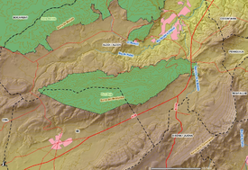
77:Map of the Font Roja Natural Park
391:
338:
292:
278:
264:
213:autonomous community of Valencia
71:
63:
192:
162:
99:
25:
1:
244:El Carrascar de la Font Roja
521:
386:
333:
308:Serra Mariola Natural Park
62:
48:
23:
230:, between the towns of
465:Natural parks of Spain
325:Font Roja Natural Park
224:Generalitat Valenciana
200:
185:Font Roja Natural Park
176:Generalitat Valenciana
36:
19:Font Roja Natural Park
505:Protected area stubs
327:(Spanish, Valencian)
250:. The summit of the
228:province of Alicante
140:38.64750°N 0.54611°W
252:Serra del Menejador
240:Valencian Community
172:Governing body
136: /
105:Valencian Community
91:Valencian Community
145:38.64750; -0.54611
412:
411:
359:
358:
181:
180:
101:Nearest city
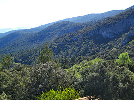
69:View of the park
512:
450:IUCN Category II
433:
426:
419:
395:
388:
380:
373:
366:
342:
335:
302:
297:
296:
295:
288:
286:Mountains portal
283:
282:
281:
274:
269:
268:
267:
151:
150:
148:
147:
146:
141:
137:
134:
133:
132:
129:
75:
67:
39:
28:
16:
520:
519:
515:
514:
513:
511:
510:
509:
440:
439:
438:
437:
385:
384:
331:
321:
298:
293:
291:
284:
279:
277:
270:
265:
263:
260:
144:
142:
138:
135:
130:
127:
125:
123:
122:
78:
70:
68:
58:
34:
12:
11:
5:
518:
516:
508:
507:
502:
497:
492:
487:
482:
477:
472:
467:
462:
457:
452:
442:
441:
436:
435:
428:
421:
413:
410:
409:
396:
383:
382:
375:
368:
360:
357:
356:
343:
329:
328:
320:
319:External links
317:
316:
315:
313:Barxell Castle
310:
304:
303:
289:
275:
259:
256:
179:
178:
173:
169:
168:
165:
161:
160:
157:
153:
152:
120:
116:
115:
102:
98:
97:
84:
80:
79:
76:
60:
59:
49:
46:
45:
21:
20:
13:
10:
9:
6:
4:
3:
2:
517:
506:
503:
501:
498:
496:
493:
491:
488:
486:
483:
481:
478:
476:
473:
471:
468:
466:
463:
461:
458:
456:
453:
451:
448:
447:
445:
434:
429:
427:
422:
420:
415:
414:
408:
406:
402:
397:
394:
390:
381:
376:
374:
369:
367:
362:
361:
355:
353:
349:
344:
341:
337:
332:
326:
323:
322:
318:
314:
311:
309:
306:
305:
301:
290:
287:
276:
273:
262:
257:
255:
253:
249:
245:
241:
237:
233:
229:
225:
220:
218:
215:, in eastern
214:
210:
206:
202:
198:
194:
190:
186:
177:
174:
170:
166:
158:
154:
149:
121:
117:
114:
110:
106:
103:
96:
92:
88:
85:
74:
66:
61:
56:
55:national park
52:
51:IUCN category
47:
43:
38:
32:
27:
22:
17:
405:expanding it
398:
352:expanding it
345:
330:
300:Birds portal
272:Spain portal
251:
248:La Teixereta
247:
243:
221:
207:situated in
205:natural park
184:
182:
460:Green Spain
164:Established
143: /
119:Coordinates
444:Categories
128:38°38′51″N
211:, in the
189:Valencian
131:0°32′46″W
31:Valencian
258:See also
159:2.450 ha
83:Location
203:) is a
197:Spanish
42:Spanish
246:) and
455:Alcoy
232:Alcoy
217:Spain
209:Alcoy
109:Alcoy
95:Spain
87:Alcoy
401:stub
348:stub
234:and
183:The
167:1987
156:Area
53:II (
236:Ibi
113:Ibi
446::
219:.
199::
195:,
191::
111:,
107::
93:,
89:,
33:)
432:e
425:t
418:v
407:.
379:e
372:t
365:v
354:.
187:(
57:)
44:)
40:(
29:(
Text is available under the Creative Commons Attribution-ShareAlike License. Additional terms may apply.

