46:
76:
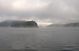
301:. It has an average depth of 135 feet (41 m) and reaches a maximum depth of 440 feet (130 m), making it the deepest lake in North Carolina. The lake has many inlets into coves and many islands formed from former mountain peaks, especially near the eastern end. As with most dam-impounded lakes, the steep banks are exposed when water levels are low. Many towns were submerged shortly after the creation of Fontana Lake, such as
29:
83:
53:
312:
Fontana Lake provides the only access into the most remote areas of the
National Park, unless visitors undertake a multi-day hike to get there. When the lake is at the normal summer level, a boat may be used to access remote trailheads such as Hazel Creek. From the observation tower on
317:, on a clear day the lake can be seen nearly a mile below. While the maximum controlled elevation of the lake (top of dam gates) is 1,710 ft (520 m), the normal Summer surface elevation is 1,703 ft (519 m).
336:
Fontana is named after a
Montvale Lumber Company logging town that was once situated at the mouth of Eagle Creek on the lake's north shore. The name is derived from the Italian word for "fountain".
478:
458:
473:
453:
45:
463:
134:
75:
448:
306:
345:
286:
468:
443:
322:
274:
108:
278:
112:
298:
318:
290:
428:
423:
302:
270:
203:
185:
196:
325:, between Bryson City and Wesser/Lauada, briefly skims an inlet at the extreme southeastern edge.
293:. Depending on water levels, the lake is about 17 miles (27 km) long. The eastern end is the
178:
294:
189:
28:
282:
210:
116:
437:
166:
120:
266:
374:
149:
136:
262:
171:
424:
U.S. Geological Survey
Geographic Names Information System: Fontana Lake
179:
197:
314:
375:"Fontana Lake, North Carolina, USA Vacation Info - Lakelubbers"
321:
roughly parallels the southern shore of the lake, and
248:
240:
232:
224:
220:
209:
195:
177:
165:
126:
104:
21:
16:
Man-made reservoir in North
Carolina, United States
479:Bodies of water of Graham County, North Carolina
459:Protected areas of Graham County, North Carolina
410:(Maryville, Tenn.: Stinnett Printing, 1989), 69.
285:. The lake forms part of the southern border of
127:
474:Bodies of water of Swain County, North Carolina
454:Protected areas of Swain County, North Carolina
8:
18:
429:Description at NorthCarolinaVacation.com
357:
289:and the northern border of part of the
7:
82:
52:
464:Great Smoky Mountains National Park
346:Hazel Creek (Great Smoky Mountains)
287:Great Smoky Mountains National Park
14:
81:
74:
51:
44:
27:
247:
239:
231:
223:
408:Hazel Creek From Then Till Now
1:
103:
95:Show map of the United States
449:Reservoirs in North Carolina
397:TVA Fontana Operating Guide
364:U.S. Geological survey 1983
495:
252:1,703 ft (519 m)
65:Show map of North Carolina
469:Nantahala National Forest
291:Nantahala National Forest
38:
26:
244:440 ft (130 m)
236:135 ft (41 m)
444:Little Tennessee River
271:Little Tennessee River
204:Little Tennessee River
186:Little Tennessee River
228:17 miles (27 km)
150:35.45278°N 83.80500°W
273:, and is located in
155:35.45278; -83.80500
146: /
256:
255:
249:Surface elevation
486:
411:
404:
398:
395:
389:
388:
386:
385:
371:
365:
362:
295:Tuckasegee River
199:
198:Primary outflows
181:
161:
160:
158:
157:
156:
151:
147:
144:
143:
142:
139:
129:
96:
85:
84:
78:
66:
55:
54:
48:
31:
19:
494:
493:
489:
488:
487:
485:
484:
483:
434:
433:
420:
415:
414:
405:
401:
396:
392:
383:
381:
373:
372:
368:
363:
359:
354:
342:
334:
328:
213: countries
190:Nantahala River
188:
180:Primary inflows
154:
152:
148:
145:
140:
137:
135:
133:
132:
100:
99:
98:
97:
94:
93:
92:
91:
90:
86:
69:
68:
67:
64:
63:
62:
61:
60:
56:
34:
17:
12:
11:
5:
492:
490:
482:
481:
476:
471:
466:
461:
456:
451:
446:
436:
435:
432:
431:
426:
419:
418:External links
416:
413:
412:
406:Duane Oliver,
399:
390:
366:
356:
355:
353:
350:
349:
348:
341:
338:
333:
330:
283:North Carolina
254:
253:
250:
246:
245:
242:
238:
237:
234:
230:
229:
226:
222:
221:
218:
217:
214:
207:
206:
201:
193:
192:
183:
175:
174:
169:
163:
162:
130:
124:
123:
117:North Carolina
106:
102:
101:
88:
87:
80:
79:
73:
72:
71:
70:
58:
57:
50:
49:
43:
42:
41:
40:
39:
36:
35:
32:
24:
23:
15:
13:
10:
9:
6:
4:
3:
2:
491:
480:
477:
475:
472:
470:
467:
465:
462:
460:
457:
455:
452:
450:
447:
445:
442:
441:
439:
430:
427:
425:
422:
421:
417:
409:
403:
400:
394:
391:
380:
376:
370:
367:
361:
358:
351:
347:
344:
343:
339:
337:
331:
329:
326:
324:
320:
316:
310:
308:
304:
300:
296:
292:
288:
284:
280:
276:
272:
268:
265:impounded by
264:
260:
251:
243:
235:
233:Average depth
227:
219:
216:United States
215:
212:
208:
205:
202:
200:
194:
191:
187:
184:
182:
176:
173:
170:
168:
164:
159:
131:
125:
122:
121:United States
118:
114:
110:
107:
77:
47:
37:
30:
25:
20:
407:
402:
393:
382:. Retrieved
378:
369:
360:
335:
327:
311:
281:counties in
259:Fontana Lake
258:
257:
89:Fontana Lake
59:Fontana Lake
33:Fontana Lake
22:Fontana Lake
379:Lakelubbers
299:Bryson City
267:Fontana Dam
225:Max. length
153: /
141:083°48′18″W
128:Coordinates
438:Categories
384:2017-05-28
352:References
241:Max. depth
138:35°27′10″N
115:counties,
263:reservoir
172:reservoir
340:See also
105:Location
303:Proctor
269:on the
315:Kuwohi
307:Judson
275:Graham
109:Graham
323:US 19
319:NC 28
297:near
279:Swain
261:is a
211:Basin
113:Swain
332:Name
305:and
277:and
167:Type
440::
377:.
309:.
119:,
111:/
387:.
Text is available under the Creative Commons Attribution-ShareAlike License. Additional terms may apply.