841:
90:
65:
48:
852:
252:. Shortly before it meets the Machias River, it bends sharply to the east before turning south again to empty into the other river. The landform between this bend and the point of confluence is locally known as "The Rim". In the 18th century it was recognized for its military value, as it provides a commanding view of the southern stretch of the Machias River and into the bay.
97:
72:
730:
825:
761:
745:
735:
906:
901:
293:
255:
Early records of the area's settlement are not clear on when The Rim was first occupied; the area was first settled by
Europeans in 1763, and the land was known to have been cleared and in agriculture use by the start of the
911:
820:
766:
876:
407:
787:
689:
268:
was built there, which was sufficient to repel an attempted landing by
British forces in the summer of 1775. In 1776 a more extensive breastwork was built, along with a watch house and barracks, and a log
720:
654:
619:
694:
599:
559:
384:
886:
659:
649:
644:
624:
740:
574:
489:
609:
604:
479:
699:
664:
569:
544:
684:
634:
614:
589:
579:
564:
554:
539:
519:
494:
484:
474:
704:
679:
584:
524:
504:
499:
469:
459:
639:
594:
534:
509:
464:
771:
669:
549:
514:
248:
toward its confluence with the East
Machias River, and then southward into the bay. The East Machias River flows generally southward from Hadley Lake, past the village center of
725:
674:
629:
529:
881:
437:
422:
377:
453:
277:
landed forces on The Rim. Guns mounted at Fort Foster fired on the first ships to arrive, but the fort was abandoned prior to the landing, and its guns were destroyed.
129:
221:, a neck of land that commands the confluence of the Machias and East Machias Rivers. The earthworks were built in 1776, and attacked by British forces in the 1777
89:
896:
891:
855:
370:
845:
64:
417:
284:
production, and its earthworks, some as much as 6 feet (1.8 m) in height, were still visible then. They have since again become overgrown.
393:
321:
226:
34:
808:
273:
was laid across the river just to the south. In August 1777, the
British once again arrived in force, and in the second
280:
After the war The Rim appears to have been abandoned and allowed to become overgrown. In the 1920s it was cleared for
813:
792:
265:
257:
210:
264:, in which a British Navy sloop was captured. After this event, the townspeople decided to fortify The Rim. A
274:
222:
427:
432:
412:
326:
249:
214:
117:
244:
Maine, and is fed primarily by the
Machias River, which flows generally eastward from the town of
270:
261:
345:
362:
47:
245:
190:
870:
826:
University and college buildings listed on the
National Register of Historic Places
237:
144:
131:
281:
241:
294:
National
Register of Historic Places listings in Washington County, Maine
821:
List of jails and prisons on the
National Register of Historic Places
907:
Conflict sites on the
National Register of Historic Places in Maine
316:
902:
National
Register of Historic Places in Washington County, Maine
912:
American Revolution on the National Register of Historic Places
366:
96:
71:
877:
Forts on the National Register of Historic Places in Maine
217:. Little more than a large earthworks, it was located on
346:"NRHP nomination for "The Rim" and Site of Fort Foster"
887:
Buildings and structures in Washington County, Maine
801:
780:
754:
713:
446:
423:
History of the National Register of Historic Places
400:
260:in 1775. Machias was the site of one of the war's
196:
183:
168:
160:
123:
113:
454:List of U.S. National Historic Landmarks by state
846:National Register of Historic Places portal
378:
8:
882:Military installations established in 1775
385:
371:
363:
46:
394:U.S. National Register of Historic Places
35:U.S. National Register of Historic Places
305:
340:
338:
336:
317:"National Register Information System"
311:
309:
18:
897:Landforms of Washington County, Maine
892:Geography of Washington County, Maine
7:
322:National Register of Historic Places
227:National Register of Historic Places
809:National Historic Preservation Act
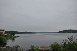
52:View toward The Rim from the south
14:
27:"The Rim" and Site of Fort Foster
851:
850:
839:
95:
88:
70:
63:
762:Federated States of Micronesia
408:Architectural style categories
225:. The site was listed on the
185:
1:
104:Show map of the United States
16:United States historic place
209:was a military site of the
928:
814:Historic Preservation Fund
793:American Legation, Morocco
258:American Revolutionary War
211:American Revolutionary War
834:
755:Lists by associated state
184:NRHP reference
57:
45:
41:
32:
25:
21:
736:Northern Mariana Islands
348:. National Park Service
233:Description and history
731:Minor Outlying Islands
714:Lists by insular areas
428:Keeper of the Register
262:first naval encounters
164:200 acres (81 ha)
433:National Park Service
413:Contributing property
327:National Park Service
145:44.71694°N 67.39583°W
788:District of Columbia
215:East Machias, Maine
150:44.71694; -67.39583
141: /
118:East Machias, Maine
864:
863:
418:Historic district
275:Battle of Machias
223:Battle of Machias
204:
203:
79:Show map of Maine
919:
854:
853:
844:
843:
842:
767:Marshall Islands
387:
380:
373:
364:
357:
356:
354:
353:
342:
331:
330:
313:
187:
179:
177:
156:
155:
153:
152:
151:
146:
142:
139:
138:
137:
134:
105:
99:
98:
92:
80:
74:
73:
67:
50:
19:
927:
926:
922:
921:
920:
918:
917:
916:
867:
866:
865:
860:
840:
838:
830:
797:
776:
750:
709:
442:
396:
391:
361:
360:
351:
349:
344:
343:
334:
329:. July 9, 2010.
315:
314:
307:
302:
290:
235:
213:in what is now
175:
173:
149:
147:
143:
140:
135:
132:
130:
128:
127:
109:
108:
107:
106:
103:
102:
101:
100:
83:
82:
81:
78:
77:
76:
75:
53:
37:
28:
17:
12:
11:
5:
925:
923:
915:
914:
909:
904:
899:
894:
889:
884:
879:
869:
868:
862:
861:
859:
858:
848:
835:
832:
831:
829:
828:
823:
818:
817:
816:
805:
803:
799:
798:
796:
795:
790:
784:
782:
778:
777:
775:
774:
769:
764:
758:
756:
752:
751:
749:
748:
746:Virgin Islands
743:
738:
733:
728:
723:
721:American Samoa
717:
715:
711:
710:
708:
707:
702:
697:
692:
687:
682:
677:
672:
667:
662:
657:
655:South Carolina
652:
647:
642:
637:
632:
627:
622:
620:North Carolina
617:
612:
607:
602:
597:
592:
587:
582:
577:
572:
567:
562:
557:
552:
547:
542:
537:
532:
527:
522:
517:
512:
507:
502:
497:
492:
487:
482:
477:
472:
467:
462:
457:
450:
448:
447:Lists by state
444:
443:
441:
440:
438:Property types
435:
430:
425:
420:
415:
410:
404:
402:
398:
397:
392:
390:
389:
382:
375:
367:
359:
358:
332:
304:
303:
301:
298:
297:
296:
289:
286:
240:is located in
234:
231:
202:
201:
198:
194:
193:
188:
181:
180:
170:
166:
165:
162:
158:
157:
125:
121:
120:
115:
111:
110:
94:
93:
87:
86:
85:
84:
69:
68:
62:
61:
60:
59:
58:
55:
54:
51:
43:
42:
39:
38:
33:
30:
29:
26:
23:
22:
15:
13:
10:
9:
6:
4:
3:
2:
924:
913:
910:
908:
905:
903:
900:
898:
895:
893:
890:
888:
885:
883:
880:
878:
875:
874:
872:
857:
849:
847:
837:
836:
833:
827:
824:
822:
819:
815:
812:
811:
810:
807:
806:
804:
800:
794:
791:
789:
786:
785:
783:
779:
773:
770:
768:
765:
763:
760:
759:
757:
753:
747:
744:
742:
739:
737:
734:
732:
729:
727:
724:
722:
719:
718:
716:
712:
706:
703:
701:
698:
696:
695:West Virginia
693:
691:
688:
686:
683:
681:
678:
676:
673:
671:
668:
666:
663:
661:
658:
656:
653:
651:
648:
646:
643:
641:
638:
636:
633:
631:
628:
626:
623:
621:
618:
616:
613:
611:
608:
606:
603:
601:
600:New Hampshire
598:
596:
593:
591:
588:
586:
583:
581:
578:
576:
573:
571:
568:
566:
563:
561:
560:Massachusetts
558:
556:
553:
551:
548:
546:
543:
541:
538:
536:
533:
531:
528:
526:
523:
521:
518:
516:
513:
511:
508:
506:
503:
501:
498:
496:
493:
491:
488:
486:
483:
481:
478:
476:
473:
471:
468:
466:
463:
461:
458:
455:
452:
451:
449:
445:
439:
436:
434:
431:
429:
426:
424:
421:
419:
416:
414:
411:
409:
406:
405:
403:
399:
395:
388:
383:
381:
376:
374:
369:
368:
365:
347:
341:
339:
337:
333:
328:
324:
323:
318:
312:
310:
306:
299:
295:
292:
291:
287:
285:
283:
278:
276:
272:
267:
263:
259:
253:
251:
247:
243:
239:
232:
230:
228:
224:
220:
216:
212:
208:
200:July 23, 1973
199:
197:Added to NRHP
195:
192:
189:
182:
171:
167:
163:
159:
154:
126:
122:
119:
116:
112:
91:
66:
56:
49:
44:
40:
36:
31:
24:
20:
660:South Dakota
650:Rhode Island
645:Pennsylvania
625:North Dakota
350:. Retrieved
320:
279:
254:
250:East Machias
236:
218:
206:
205:
114:Nearest city
781:Other areas
741:Puerto Rico
575:Mississippi
490:Connecticut
238:Machias Bay
207:Fort Foster
148: /
124:Coordinates
871:Categories
690:Washington
610:New Mexico
605:New Jersey
480:California
352:2015-04-26
300:References
266:breastwork
136:67°23′45″W
700:Wisconsin
665:Tennessee
570:Minnesota
545:Louisiana
282:blueberry
242:Down East
229:in 1973.
133:44°43′1″N
856:Category
685:Virginia
635:Oklahoma
615:New York
590:Nebraska
580:Missouri
565:Michigan
555:Maryland
540:Kentucky
520:Illinois
495:Delaware
485:Colorado
475:Arkansas
288:See also
191:73000155
802:Related
705:Wyoming
680:Vermont
585:Montana
525:Indiana
505:Georgia
500:Florida
470:Arizona
460:Alabama
246:Machias
219:The Rim
174: (
640:Oregon
595:Nevada
535:Kansas
510:Hawaii
465:Alaska
401:Topics
772:Palau
670:Texas
550:Maine
515:Idaho
169:Built
726:Guam
675:Utah
630:Ohio
530:Iowa
271:boom
176:1775
172:1775
161:Area
186:No.
873::
335:^
325:.
319:.
308:^
456::
386:e
379:t
372:v
355:.
178:)
Text is available under the Creative Commons Attribution-ShareAlike License. Additional terms may apply.