310:
723:
47:
77:
322:
84:
54:
279:
Fourmile
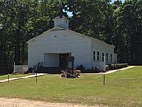
Baptist Church was founded on August 25, 1824, (under the name of Bethesda Baptist Church) and is the oldest continuously functioning church in the Shelby Baptist Association. The Shelby Baptist Association was founded at Bethesda Baptist Church in 1852. It is also one of the oldest existing
960:
288:. E. B. Teague lived on a farm in Fourmile, which he named Red Lawn. Fourmile was also the location of Blue Springs Methodist Church, which was founded in 1890. The church closed in 2004.
291:
A post office was established under the name
Redlawn in 1898, at the residence of Pickens Miner, who served as the first postmaster. The post office was in operation until 1904.
309:
594:
520:
965:
295:
365:
109:
76:
587:
46:
356:
229:
872:
426:
882:
805:
471:
269:
546:
284:. One of the prominent early members of the church was John W. Teague, who was an early settler of Columbiana and the father of
747:
580:
361:
273:
524:
572:
321:
404:
163:
281:
473:
The
Baptist Encyclopaedia: A Dictionary of the Doctrines, Ordinances ... of ... - William Cathcart - Google Books
217:
141:
351:
795:
780:
767:
700:
930:
847:
775:
604:
253:
222:
168:
742:
937:
815:
800:
790:
752:
265:
202:
835:
690:
667:
650:
626:
261:
249:
32:
862:
785:
645:
379:
448:
825:
820:
712:
192:
907:
902:
887:
857:
706:
662:
494:
892:
867:
810:
757:
695:
678:
672:
656:
852:
684:
954:
897:
554:
285:
619:
151:
124:
111:
183:
921:‡This populated place also has portions in an adjacent county or counties
260:, United States. Fourmile is located 4 miles (6.4 km) northeast of
257:
156:
209:
188:
722:
734:
637:
547:"Properties on the Alabama Register of Landmarks & Heritage"
294:
One site in
Fourmile, Jackson's Fourmile Farm, is listed on the
576:
721:
427:"Fourmile Baptist Church celebrates 188th homecoming"
961:
Unincorporated communities in Shelby County, Alabama
916:
834:
766:
733:
636:
268:. Some of the early settlers of Fourmile came from
228:
216:
199:
182:
174:
162:
150:
140:
23:
18:Unincorporated community in Alabama, United States
588:
8:
595:
581:
573:
523:. Jim Forte Postal History. Archived from
451:. Rootsweb.ancestry.com. November 24, 1902
407:. Shelby County Reporter. October 29, 2002
380:"Sketches of the History of Shelby County"
296:Alabama Register of Landmarks and Heritage
20:
726:Map of Alabama highlighting Shelby County
315:The former Blue Springs Methodist Church.
83:
53:
366:United States Department of the Interior
338:
305:
227:
215:
181:
173:
139:
104:
38:
495:"Tidbits of the Past in Shelby County"
405:"Baptists celebrate 150th anniversary"
346:
344:
342:
966:Unincorporated communities in Alabama
553:. www.preserveala.org. Archived from
198:
161:
149:
7:
357:Geographic Names Information System
603:Municipalities and communities of
501:. Shelby County Historical Society
385:. Shelby County Historical Society
264:and 3 miles (4.8 km) west of
14:
499:Shelby County Historical Society
320:
308:
82:
75:
52:
45:
362:United States Geological Survey
274:Newberry County, South Carolina
1:
551:Alabama Historical Commission
449:"Early History of Columbiana"
96:Show map of the United States
982:
470:Cathcart, William (1883).
282:Alabama Baptist Convention
926:
719:
617:
105:
39:
30:
429:. Shelby County Reporter
250:unincorporated community
178:463 ft (141 m)
33:Unincorporated community
327:Fourmile Baptist Church
748:Indian Springs Village
727:
606:Shelby County, Alabama
725:
201: • Summer (
125:33.24861°N 86.55306°W
939:United States portal
557:on September 4, 2012
527:on October 22, 2014
130:33.24861; -86.55306
121: /
66:Show map of Alabama
728:
948:
947:
239:
238:
90:Fourmile, Alabama
60:Fourmile, Alabama
25:Fourmile, Alabama
973:
940:
933:
724:
629:
622:
612:
607:
597:
590:
583:
574:
567:
566:
564:
562:
543:
537:
536:
534:
532:
517:
511:
510:
508:
506:
491:
485:
484:
482:
480:
467:
461:
460:
458:
456:
445:
439:
438:
436:
434:
423:
417:
416:
414:
412:
401:
395:
394:
392:
390:
384:
376:
370:
369:
348:
324:
312:
286:Eldred B. Teague
280:churches of the
270:Lexington County
244:, also known as
206:
136:
135:
133:
132:
131:
126:
122:
119:
118:
117:
114:
97:
86:
85:
79:
67:
56:
55:
49:
21:
981:
980:
976:
975:
974:
972:
971:
970:
951:
950:
949:
944:
938:
931:
922:
912:
839:
837:
830:
762:
729:
717:
632:
627:
620:
613:
610:
605:
601:
571:
570:
560:
558:
545:
544:
540:
530:
528:
521:"Shelby County"
519:
518:
514:
504:
502:
493:
492:
488:
478:
476:
469:
468:
464:
454:
452:
447:
446:
442:
432:
430:
425:
424:
420:
410:
408:
403:
402:
398:
388:
386:
382:
378:
377:
373:
350:
349:
340:
335:
328:
325:
316:
313:
304:
200:
129:
127:
123:
120:
115:
112:
110:
108:
107:
101:
100:
99:
98:
95:
94:
93:
92:
91:
87:
70:
69:
68:
65:
64:
63:
62:
61:
57:
35:
26:
19:
12:
11:
5:
979:
977:
969:
968:
963:
953:
952:
946:
945:
943:
942:
935:
932:Alabama portal
927:
924:
923:
920:
918:
914:
913:
911:
910:
905:
900:
895:
890:
885:
880:
875:
870:
865:
860:
855:
850:
844:
842:
838:unincorporated
832:
831:
829:
828:
823:
818:
813:
808:
803:
798:
796:Highland Lakes
793:
788:
783:
781:Brook Highland
778:
772:
770:
764:
763:
761:
760:
755:
750:
745:
739:
737:
731:
730:
720:
718:
716:
715:
710:
704:
701:Vestavia Hills
698:
693:
688:
682:
676:
670:
665:
660:
654:
648:
642:
640:
634:
633:
618:
615:
614:
602:
600:
599:
592:
585:
577:
569:
568:
538:
512:
486:
462:
440:
418:
396:
371:
337:
336:
334:
331:
330:
329:
326:
319:
317:
314:
307:
303:
300:
237:
236:
233:
226:
225:
220:
214:
213:
207:
197:
196:
186:
180:
179:
176:
172:
171:
166:
160:
159:
154:
148:
147:
144:
138:
137:
103:
102:
89:
88:
81:
80:
74:
73:
72:
71:
59:
58:
51:
50:
44:
43:
42:
41:
40:
37:
36:
31:
28:
27:
24:
17:
13:
10:
9:
6:
4:
3:
2:
978:
967:
964:
962:
959:
958:
956:
941:
936:
934:
929:
928:
925:
919:
915:
909:
906:
904:
901:
899:
896:
894:
891:
889:
886:
884:
881:
879:
876:
874:
871:
869:
866:
864:
861:
859:
856:
854:
851:
849:
848:Abbot Springs
846:
845:
843:
841:
833:
827:
824:
822:
819:
817:
814:
812:
809:
807:
804:
802:
799:
797:
794:
792:
789:
787:
784:
782:
779:
777:
776:Brantleyville
774:
773:
771:
769:
765:
759:
756:
754:
751:
749:
746:
744:
741:
740:
738:
736:
732:
714:
711:
708:
705:
702:
699:
697:
694:
692:
689:
686:
683:
680:
677:
674:
671:
669:
666:
664:
661:
658:
655:
652:
649:
647:
644:
643:
641:
639:
635:
631:
630:
623:
616:
611:United States
608:
598:
593:
591:
586:
584:
579:
578:
575:
556:
552:
548:
542:
539:
526:
522:
516:
513:
500:
496:
490:
487:
475:
474:
466:
463:
450:
444:
441:
428:
422:
419:
406:
400:
397:
381:
375:
372:
367:
363:
359:
358:
353:
347:
345:
343:
339:
332:
323:
318:
311:
306:
301:
299:
297:
292:
289:
287:
283:
277:
275:
271:
267:
263:
259:
255:
254:Shelby County
251:
247:
243:
234:
231:
224:
221:
219:
211:
208:
204:
194:
193:Central (CST)
190:
187:
185:
177:
170:
167:
165:
158:
155:
153:
146:United States
145:
143:
134:
106:Coordinates:
78:
48:
34:
29:
22:
16:
877:
743:Harpersville
625:
559:. Retrieved
555:the original
550:
541:
529:. Retrieved
525:the original
515:
503:. Retrieved
498:
489:
477:. Retrieved
472:
465:
453:. Retrieved
443:
431:. Retrieved
421:
409:. Retrieved
399:
387:. Retrieved
374:
355:
293:
290:
278:
245:
241:
240:
218:Area code(s)
15:
840:communities
816:Shoal Creek
801:Meadowbrook
791:Eagle Point
753:Wilsonville
621:County seat
531:October 22,
505:October 22,
479:October 22,
389:November 2,
266:Wilsonville
128: /
955:Categories
873:Cloverdale
691:Montevallo
668:Columbiana
651:Birmingham
628:Columbiana
352:"Fourmile"
333:References
262:Columbiana
232:feature ID
116:86°33′11″W
113:33°14′55″N
917:Footnotes
883:Inverness
863:Arkwright
806:Pea Ridge
786:Dunnavant
646:Alabaster
184:Time zone
175:Elevation
878:Fourmile
826:Vandiver
821:Sterrett
713:Westover
248:, is an
242:Fourmile
223:205, 659
908:Siluria
903:Saginaw
888:Maylene
858:Aldrich
707:Vincent
663:Chelsea
561:June 5,
455:May 31,
433:May 31,
411:May 31,
302:Gallery
258:Alabama
246:Redlawn
157:Alabama
142:Country
893:Nelson
868:Calcis
811:Shelby
758:Wilton
696:Pelham
679:Hoover
673:Helena
657:Calera
638:Cities
235:156374
169:Shelby
164:County
853:Acton
836:Other
735:Towns
685:Leeds
383:(PDF)
212:(CDT)
210:UTC-5
189:UTC-6
152:State
898:Ryan
768:CDPs
563:2014
533:2014
507:2014
481:2014
457:2014
435:2014
413:2014
391:2014
272:and
230:GNIS
252:in
203:DST
957::
624::
609:,
549:.
497:.
364:,
360:.
354:.
341:^
298:.
276:.
256:,
709:‡
703:‡
687:‡
681:‡
675:‡
659:‡
653:‡
596:e
589:t
582:v
565:.
535:.
509:.
483:.
459:.
437:.
415:.
393:.
368:.
205:)
195:)
191:(
Text is available under the Creative Commons Attribution-ShareAlike License. Additional terms may apply.