446:
32:
434:
386:
410:
65:
470:
422:
458:
72:
39:
398:
445:
280:, at 76 metres (249 ft) above sea level. The southern and eastern coasts are relatively smooth, but the northern coast is very jagged with many
31:
249:. The 152-square-kilometre (59 sq mi) island makes up about 63% of the land area of Frøya municipality. The island lies in a large
358:". The oldest meaning of the common word was "(the one) in front; the foremost, the leading" and here in the sense "the island in front of
121:
397:
569:
344:
574:
409:
276:
as well as marshes and lakes. There are no naturally forested areas on the island. The highest point on the island is
64:
385:
433:
486:
469:
457:
238:
222:
515:
285:
549:(in Norwegian) (14 ed.). Kristiania, Norge: W. C. Fabritius & sønners bogtrikkeri. p. 55.
421:
343:
is 'the Frøy'). Therefore, the name of the island probably has the same root as the name of the
520:
254:
371:
312:
292:
296:
277:
262:
258:
188:
563:
300:
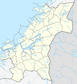
242:
212:
105:
544:
250:
261:
lies to the south of the island and that separates it from the large island of
136:
123:
540:
324:
273:
339:
in the modern form is actually the definite article - so the meaning of
269:
253:
of islands in the Frøyhavet sea, just northwest of the entrance to the
510:
320:
246:
234:
109:
359:
347:
281:
355:
351:
299:. The island of Hitra is then connected to the mainland by the
362:". Until 1906 the island and municipality name was spelled
350:, brother to Freyja. The names originally were titles: "
311:
The name of the island (and municipality) comes from
218:
208:
194:
184:
176:
168:
160:
152:
115:
101:
96:
291:The island is connected to the mainland via the
319:is a variant of the name of the Norse goddess
8:
288:lies at the southwestern tip of the island.
19:
18:
546:Norske gaardnavne: Søndre Trondhjems amt
498:
381:
504:
502:
295:which connects it to the neighboring
7:
156:151.9 km (58.6 sq mi)
327:form of the name of the island was
509:Haugen, Morten, ed. (2017-09-12).
14:
468:
456:
444:
432:
420:
408:
396:
384:
70:
63:
37:
30:
1:
71:
38:
370:is the definite article in
591:
487:List of islands of Norway
268:The island is rocky with
199:
164:28 km (17.4 mi)
24:
172:12 km (7.5 mi)
180:76 m (249 ft)
177:Highest elevation
51:Location of the island
516:Store norske leksikon
286:Sletringen Lighthouse
54:Show map of Trøndelag
570:Islands of Trøndelag
137:63.6721°N 08.3343°E
133: /
21:
451:Plantlife on Frøya
185:Highest point
87:Show map of Norway
521:Kunnskapsforlaget
255:Trondheimsfjorden
228:
227:
582:
575:Frøya, Trøndelag
551:
550:
537:
531:
530:
528:
527:
519:(in Norwegian).
506:
472:
463:Houses in Titran
460:
448:
436:
424:
412:
400:
388:
372:Danish-Norwegian
241:municipality in
148:
147:
145:
144:
143:
142:63.6721; 08.3343
138:
134:
131:
130:
129:
126:
88:
74:
73:
67:
55:
41:
40:
34:
22:
16:Island in Norway
590:
589:
585:
584:
583:
581:
580:
579:
560:
559:
557:
555:
554:
539:
538:
534:
525:
523:
508:
507:
500:
495:
483:
476:
473:
464:
461:
452:
449:
440:
437:
428:
425:
416:
413:
404:
401:
392:
389:
380:
313:Norse mythology
309:
297:island of Hitra
204:
141:
139:
135:
132:
127:
124:
122:
120:
119:
92:
91:
90:
89:
86:
85:
82:
81:
80:
79:
75:
58:
57:
56:
53:
52:
49:
48:
47:
46:
42:
17:
12:
11:
5:
588:
586:
578:
577:
572:
562:
561:
553:
552:
532:
497:
496:
494:
491:
490:
489:
482:
479:
478:
477:
475:View of Titran
474:
467:
465:
462:
455:
453:
450:
443:
441:
438:
431:
429:
426:
419:
417:
414:
407:
405:
403:House on Frøya
402:
395:
393:
390:
383:
379:
376:
308:
305:
278:Besselvassheia
226:
225:
220:
216:
215:
210:
206:
205:
200:
197:
196:
195:Administration
192:
191:
189:Besselvassheia
186:
182:
181:
178:
174:
173:
170:
166:
165:
162:
158:
157:
154:
150:
149:
117:
113:
112:
103:
99:
98:
94:
93:
84:Frøya (Norway)
83:
77:
76:
69:
68:
62:
61:
60:
59:
50:
44:
43:
36:
35:
29:
28:
27:
26:
25:
15:
13:
10:
9:
6:
4:
3:
2:
587:
576:
573:
571:
568:
567:
565:
558:
548:
547:
542:
536:
533:
522:
518:
517:
512:
505:
503:
499:
492:
488:
485:
484:
480:
471:
466:
459:
454:
447:
442:
435:
430:
423:
418:
415:Road on Frøya
411:
406:
399:
394:
387:
382:
378:Media gallery
377:
375:
373:
369:
365:
361:
357:
353:
349:
346:
342:
338:
334:
330:
326:
322:
318:
314:
306:
304:
302:
298:
294:
289:
287:
283:
279:
275:
271:
266:
264:
260:
256:
252:
248:
244:
240:
236:
232:
224:
221:
217:
214:
211:
207:
203:
198:
193:
190:
187:
183:
179:
175:
171:
167:
163:
159:
155:
151:
146:
118:
114:
111:
107:
104:
100:
95:
66:
33:
23:
556:
545:
535:
524:. Retrieved
514:
511:"Frøya – øy"
367:
363:
340:
336:
335:(the ending
332:
328:
316:
315:. Although
310:
301:Hitra Tunnel
293:Frøya Tunnel
290:
284:and coves.
267:
230:
229:
219:Municipality
201:
259:Frøyfjorden
251:archipelago
140: /
116:Coordinates
564:Categories
541:Rygh, Oluf
526:2018-02-19
493:References
125:63°40′20″N
439:Sistranda
345:Norse god
325:Old Norse
272:-covered
243:Trøndelag
213:Trøndelag
128:8°20′03″E
106:Trøndelag
97:Geography
543:(1901).
481:See also
274:moorland
245:county,
102:Location
427:Husvika
391:Flatval
270:heather
257:. The
364:Frøien
354:" or "
323:, the
321:Freyja
282:fjords
247:Norway
235:island
233:is an
209:County
202:Norway
161:Length
110:Norway
360:Hitra
348:Freyr
341:Frøya
317:Frøya
263:Hitra
239:Frøya
231:Frøya
223:Frøya
169:Width
78:Frøya
45:Frøya
20:Frøya
356:lady
352:lord
333:Frey
329:Frøy
307:Name
153:Area
374:).
368:-en
331:or
237:in
566::
513:.
501:^
337:-a
303:.
265:.
108:,
529:.
366:(
Text is available under the Creative Commons Attribution-ShareAlike License. Additional terms may apply.