464:
65:
95:
45:
102:
72:
791:
286:
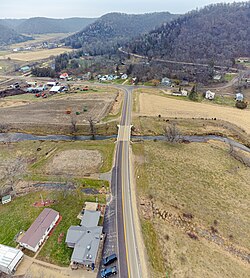
A post office was established at
Freeburg in 1858, and remained in operation until it was discontinued in 1947. The community was originally built up chiefly by Germans, who named it after the city of
371:
772:
533:
498:
796:
543:
483:
127:
528:
518:
488:
553:
558:
513:
493:
801:
523:
563:
538:
508:
548:
503:
49:
364:
765:
247:
94:
357:
64:
758:
349:
44:
181:
684:
654:
738:
634:
381:
267:
186:
708:
263:
235:
159:
320:
309:
639:
588:
453:
649:
603:
447:
422:
659:
613:
715:
598:
427:
403:
220:
629:
608:
573:
35:
339:
674:
664:
644:
619:
442:
432:
287:
210:
742:
321:
U.S. Geological Survey
Geographic Names Information System: Freeburg Post Office (historical)
437:
624:
333:
583:
475:
785:
240:
396:
310:
U.S. Geological Survey
Geographic Names Information System: Freeburg, Minnesota
271:
169:
142:
129:
275:
201:
174:
699:‡This populated place also has portions in an adjacent county or counties
463:
335:
Minnesota
Geographic Names: Their Origin and Historic Significance
227:
206:
414:
353:
462:
792:
Unincorporated communities in
Houston County, Minnesota
746:
21:
Unincorporated community in
Minnesota, United States
16:
Unincorporated community in
Minnesota, United States
694:
673:
572:
474:
413:
246:
234:
217:
200:
192:
180:
168:
158:
26:
766:
365:
8:
467:Map of Minnesota highlighting Houston County
773:
759:
372:
358:
350:
23:
338:. Minnesota Historical Society. p.
797:Unincorporated communities in Minnesota
299:
245:
233:
199:
191:
157:
122:
56:
41:
305:
303:
216:
179:
167:
7:
734:
732:
802:Southeast Minnesota geography stubs
745:. You can help Knowledge (XXG) by
380:Municipalities and communities of
14:
737:This article about a location in
101:
100:
93:
71:
70:
63:
43:
1:
114:Show map of the United States
685:Ho-Chunk Indian Reservation
818:
731:
739:Houston County, Minnesota
704:
460:
394:
383:Houston County, Minnesota
123:
57:
42:
33:
264:unincorporated community
196:686 ft (209 m)
36:Unincorporated community
468:
332:Upham, Warren (1920).
466:
219: • Summer (
143:43.61111°N 91.36417°W
84:Show map of Minnesota
717:United States portal
148:43.61111; -91.36417
139: /
469:
52:flows through town
754:
753:
726:
725:
288:Freiburg, Germany
257:
256:
809:
775:
768:
761:
733:
718:
711:
710:Minnesota portal
655:Willington Grove
465:
406:
399:
389:
384:
374:
367:
360:
351:
344:
343:
329:
323:
318:
312:
307:
224:
154:
153:
151:
150:
149:
144:
140:
137:
136:
135:
132:
115:
104:
103:
97:
85:
74:
73:
67:
47:
24:
817:
816:
812:
811:
810:
808:
807:
806:
782:
781:
780:
779:
729:
727:
722:
716:
709:
700:
690:
676:
669:
575:
568:
470:
458:
409:
404:
397:
390:
387:
382:
378:
348:
347:
331:
330:
326:
319:
315:
308:
301:
296:
284:
218:
147:
145:
141:
138:
133:
130:
128:
126:
125:
119:
118:
117:
116:
113:
112:
111:
110:
109:
105:
88:
87:
86:
83:
82:
81:
80:
79:
75:
53:
38:
29:
22:
17:
12:
11:
5:
815:
813:
805:
804:
799:
794:
784:
783:
778:
777:
770:
763:
755:
752:
751:
724:
723:
721:
720:
713:
705:
702:
701:
698:
696:
692:
691:
689:
688:
681:
679:
671:
670:
668:
667:
662:
657:
652:
647:
642:
637:
635:River Junction
632:
627:
622:
617:
611:
606:
601:
596:
591:
586:
580:
578:
574:Unincorporated
570:
569:
567:
566:
561:
556:
551:
546:
541:
536:
531:
526:
521:
516:
511:
506:
501:
496:
491:
486:
480:
478:
472:
471:
461:
459:
457:
456:
451:
445:
440:
435:
430:
425:
419:
417:
411:
410:
395:
392:
391:
379:
377:
376:
369:
362:
354:
346:
345:
324:
313:
298:
297:
295:
292:
283:
280:
268:Houston County
255:
254:
251:
244:
243:
238:
232:
231:
225:
215:
214:
204:
198:
197:
194:
190:
189:
184:
178:
177:
172:
166:
165:
162:
156:
155:
121:
120:
107:
106:
99:
98:
92:
91:
90:
89:
77:
76:
69:
68:
62:
61:
60:
59:
58:
55:
54:
48:
40:
39:
34:
31:
30:
27:
20:
15:
13:
10:
9:
6:
4:
3:
2:
814:
803:
800:
798:
795:
793:
790:
789:
787:
776:
771:
769:
764:
762:
757:
756:
750:
748:
744:
740:
735:
730:
719:
714:
712:
707:
706:
703:
697:
693:
686:
683:
682:
680:
678:
672:
666:
663:
661:
658:
656:
653:
651:
648:
646:
643:
641:
638:
636:
633:
631:
628:
626:
623:
621:
618:
615:
612:
610:
607:
605:
602:
600:
597:
595:
592:
590:
587:
585:
582:
581:
579:
577:
571:
565:
562:
560:
557:
555:
552:
550:
547:
545:
542:
540:
537:
535:
534:Mound Prairie
532:
530:
527:
525:
522:
520:
517:
515:
512:
510:
507:
505:
502:
500:
499:Crooked Creek
497:
495:
492:
490:
487:
485:
482:
481:
479:
477:
473:
455:
452:
449:
446:
444:
441:
439:
436:
434:
431:
429:
426:
424:
421:
420:
418:
416:
412:
408:
407:
400:
393:
388:United States
385:
375:
370:
368:
363:
361:
356:
355:
352:
341:
337:
336:
328:
325:
322:
317:
314:
311:
306:
304:
300:
293:
291:
289:
281:
279:
277:
273:
269:
265:
261:
252:
249:
242:
239:
237:
229:
226:
222:
212:
211:Central (CST)
208:
205:
203:
195:
188:
185:
183:
176:
173:
171:
164:United States
163:
161:
152:
124:Coordinates:
96:
66:
51:
50:Crooked Creek
46:
37:
32:
25:
19:
747:expanding it
736:
728:
640:Schechs Mill
593:
589:Black Hammer
544:Spring Grove
484:Black Hammer
454:Spring Grove
402:
334:
327:
316:
285:
259:
258:
18:
677:reservation
650:South Ridge
604:Money Creek
576:communities
529:Money Creek
519:La Crescent
489:Brownsville
448:La Crescent
423:Brownsville
398:County seat
146: /
786:Categories
660:Wilmington
614:Pine Creek
554:Wilmington
294:References
272:U.S. state
250:feature ID
134:91°21′51″W
131:43°36′40″N
695:Footnotes
599:Jefferson
559:Winnebago
514:Jefferson
494:Caledonia
476:Townships
428:Caledonia
405:Caledonia
276:Minnesota
270:, in the
236:Area code
202:Time zone
193:Elevation
175:Minnesota
630:Riceford
609:Newhouse
594:Freeburg
524:Mayville
260:Freeburg
108:Freeburg
78:Freeburg
28:Freeburg
665:Yucatan
645:Sheldon
620:Perkins
564:Yucatan
539:Sheldon
509:Houston
443:Houston
282:History
187:Houston
160:Country
675:Indian
433:Eitzen
415:Cities
262:is an
253:643918
182:County
741:is a
549:Union
504:Hokah
438:Hokah
230:(CDT)
228:UTC-5
207:UTC-6
170:State
743:stub
625:Reno
248:GNIS
584:Bee
340:238
274:of
266:in
241:507
221:DST
788::
401::
386:,
302:^
290:.
278:.
774:e
767:t
760:v
749:.
687:‡
616:‡
450:‡
373:e
366:t
359:v
342:.
223:)
213:)
209:(
Text is available under the Creative Commons Attribution-ShareAlike License. Additional terms may apply.