99:
mill, general store and the home place served many needs. In addition to grinding wheat, corn and livestock feed, the store served as a post office, restaurant, operating theatre, judges' court room, voting place, political speaking place, library, boxing matches, horseshoe pitching tournaments, checkers tournaments, circuit church and almost everything else one could imagine prosperous Clear Creek Valley. The lives of many of the Valley's folk were shattered, but as soon as the war ended they went to work rebuilding the once proud Fall River community that embodied the true pioneer spirit of the times.
314:
86:
302:
17:
362:
386:
338:
422:
434:
398:
350:
326:
374:
410:
290:
118:. They built a dam across the Clear Creek at the head of the bluffs creating a large thirty-acre millpond that would allow the mill to operate 24/7 even when the creek was low during drought seasons. Fall River was once again on the rise and its success helped revitalize and stabilize the Clear Creek Valley for the next 50 years.
110:
raided through middle
Tennessee and following a "scorched earth" policy, they burned the mill to the ground. Fortunately the mill owner and his family's lives were spared, but it was a devastating blow to the very peaceful and once proud Fall River community that embodied the true pioneer spirit of
131:
at Fall River. Above the great waterfalls, you can hear the faint voices of the mule drivers and creaking wagon wheels early in the morning as they arrive with their heavy loads of wheat and corn and line up for what will be a long day at the mill. But these early pioneers are happy to be here, to
98:
The mill and general store served as the center of the Fall River settlement in the Clear Creek Valley in 1823. As the settlement grew and prospered, two churches, a school, a blacksmith shop, a tannery, a timber sawmill, a sorghum mill, and a cemetery were also built. For the next 130 years, the
121:
In 1914 G. T. Wilburn (the second generation of current owners) took over the management of the mill and the general store. Under his guidance and stewardship the mills' productivity grew. His ingenious ability to adapt paired with his acclaimed knowledge of how to grind the best wheat and corn
126:
automobile and truck ownership grew. In 1924 G.T. and his wife
Florence bought out the other family members and dedicated their lives to the Fall River community. Take a 200-year walk back in time to the early 1800s as you stroll around the historic
161:·1924 – G. T. Wilburn and his wife Florence purchased the Mill, Mill Store, farm house, barn and small rental house (all covering 15 acres) and he renamed the Mill and Country Store as G. T. Wilburn and Son's Mill and General Store.
361:
132:
meet their neighbors, trade stories, get up-to-date on local happenings and shop for necessities at the general store as they await the grinding of what will be their survival food for the coming winter.
485:
114:
Twenty years later, in 1885, the first family members of the current owners of the Fall River community properties arrived and infused new cutting technologies and equipment for wheat and corn
225:
337:
155:.1885 – Ownership passed to the White family and they installed a dam and a water driven turbine that powered the machinery for grinding fine flour that is still in the Mill today.
313:
40:
Its elevation is 774 feet. Fall River appears on the
Bodenham U.S. Geological Survey Map. Lawrence County is in the Central Time Zone. Fall River lies within the (931) area code.
385:
446:
397:
58:
Lawrence County, Tennessee, is a county located in the U.S. state of
Tennessee. As of the 2013 census, the population was 41,990. Its county seat and largest city is
421:
146:·1862 – The Union Army burned the Mill to the ground as they swept through the South on a "scorched earth" policy. Fortunately the Hagan Family was spared.
301:
433:
409:
490:
373:
222:
495:
349:
289:
367:
This is the historic farmhouse located at 17 Wilburn Mill Rd., Fall River, TN. This was the home of G.T. and
Florence Wilburn.
325:
85:
82:
Mount Zion United
Methodist Church is a historic church in Lawrence County, Tennessee, near the Fall River community.
149:·1865 – Summer, the Civil War was over and John Hagan began rebuilding the Mill on the same spot as the burned mill.
158:·1909 – Mr. White employed G. T. Wilburn (his wife Tenny's nephew) to manage the Mill and the Mill's Country store.
52:
76:
59:
16:
223:
http://lawrencecountytnhistory.org/2014/02/18/caleb-davis-a-unionist-black-sheep-in-civil-war-lawrenceburg/
122:
products brought regional fame to the mill. It also brought new customers from a fifty-mile radius as the
66:
241:
48:
343:
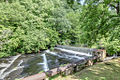
The drop of the falls on Clear Creek at Fall River
Community, TN. This was a local bathing shower.
128:
115:
103:
403:
Tool and Tack Shed located at the G.T. Wilburn Grist Mill property in Fall River, Tennessee.
140:·1823– Construction began and the exact date of completion is unknown on the original Mill.
44:
29:
229:
47:. The population is not reported but is believed to be approximately 300. Leoma is an
479:
391:
The Fall River
Community Cemetery. This is a very old cemetery dating back to 1860.
427:
G.T. Wilburn store located across the road from the mill at Fall River, Tennessee.
69:. It is approximately 76 miles north and has a population of 609,644 as of 2011.
415:
Barns located on the G.T. Wilburn Grist Mill property in Fall River, Tennessee.
143:·John A. Hagan was the first recorded deed owner. It was a water driven mill.
123:
107:
461:
448:
89:
The falls of Clear Creek located in the community of Fall River, Tennessee.
439:
The grave of G.T. and
Florence Wilburn located at the Fall River Cemetery.
379:
A field pond used by the cows raised at the G.T. Wilburn Grist Mill.
275:
84:
15:
242:
http://us.geoview.info/wilburn_mill_looking_at_the_dam,54308242p
152:·1870 – Ownership passed from John Hagan to the Scott family.
319:
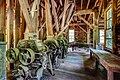
Milling machinery located inside the G.T. Wilburn Grist Mill.
295:
Wilburn Mill Road Sign, Fall River
Community, Tennessee
65:
The nearest city with population of 200,000 or more is
43:
Fall River is a community located within the region of
486:
Buildings and structures in Lawrence County, Tennessee
307:
Machinery located inside the G.T. Wilburn Grist Mill.
355:
The G.T. Wilburn Grist Mill as it sits on the falls.
253:Lawrence County, Tennessee Genealogical Society
72:The coordinates are 35°07'49.9"N 87°13'04.0"W.
8:
75:The mill is located just 13 miles from the
285:
180:Roadside Thoughts, Fall River Tennessee
170:
331:The falls at the Fall River Community.
188:
186:
7:
213:Lawrence County by Kathy Niedergeses
200:
198:
176:
174:
28:is in the Fall River community, in
20:G.T. Wilburn Grist Mill Water Wheel
14:
262:Deceased;Clyde Wilburn's writings
102:In 1862, at the beginning of the
491:Flour mills in the United States
432:
420:
408:
396:
384:
372:
360:
348:
336:
324:
312:
300:
288:
1:
192:City of Lawrenceburg website
79:in Lawrenceburg, Tennessee.
496:Grinding mills in Tennessee
512:
53:Lawrence County, Tennessee
77:David Crockett State Park
49:unincorporated community
462:35.130528°N 87.217778°W
60:Lawrenceburg, Tennessee
26:G.T. Wilburn Grist Mill
90:
21:
467:35.130528; -87.217778
88:
19:
67:Nashville, Tennessee
458: /
228:2014-11-11 at the
129:water-powered mill
91:
22:
503:
473:
472:
470:
469:
468:
463:
459:
456:
455:
454:
451:
436:
424:
412:
400:
388:
376:
364:
352:
340:
328:
316:
304:
292:
276:Official website
263:
260:
254:
251:
245:
239:
233:
220:
214:
211:
205:
202:
193:
190:
181:
178:
45:Leoma, Tennessee
30:Leoma, Tennessee
511:
510:
506:
505:
504:
502:
501:
500:
476:
475:
466:
464:
460:
457:
452:
449:
447:
445:
444:
440:
437:
428:
425:
416:
413:
404:
401:
392:
389:
380:
377:
368:
365:
356:
353:
344:
341:
332:
329:
320:
317:
308:
305:
296:
293:
284:
272:
267:
266:
261:
257:
252:
248:
240:
236:
230:Wayback Machine
221:
217:
212:
208:
203:
196:
191:
184:
179:
172:
167:
138:
96:
38:
12:
11:
5:
509:
507:
499:
498:
493:
488:
478:
477:
442:
441:
438:
431:
429:
426:
419:
417:
414:
407:
405:
402:
395:
393:
390:
383:
381:
378:
371:
369:
366:
359:
357:
354:
347:
345:
342:
335:
333:
330:
323:
321:
318:
311:
309:
306:
299:
297:
294:
287:
283:
280:
279:
278:
271:
270:External links
268:
265:
264:
255:
246:
234:
215:
206:
194:
182:
169:
168:
166:
163:
137:
134:
95:
92:
37:
34:
13:
10:
9:
6:
4:
3:
2:
508:
497:
494:
492:
489:
487:
484:
483:
481:
474:
471:
435:
430:
423:
418:
411:
406:
399:
394:
387:
382:
375:
370:
363:
358:
351:
346:
339:
334:
327:
322:
315:
310:
303:
298:
291:
286:
282:Photo gallery
281:
277:
274:
273:
269:
259:
256:
250:
247:
243:
238:
235:
231:
227:
224:
219:
216:
210:
207:
201:
199:
195:
189:
187:
183:
177:
175:
171:
164:
162:
159:
156:
153:
150:
147:
144:
141:
135:
133:
130:
125:
119:
117:
112:
109:
105:
100:
93:
87:
83:
80:
78:
73:
70:
68:
63:
61:
56:
54:
50:
46:
41:
35:
33:
31:
27:
18:
453:87°13′04.0″W
450:35°07′49.9″N
443:
258:
249:
237:
218:
209:
160:
157:
154:
151:
148:
145:
142:
139:
120:
113:
101:
97:
81:
74:
71:
64:
57:
42:
39:
25:
23:
465: /
111:the times.
51:located in
480:Categories
165:References
124:Henry Ford
108:Union Army
104:Civil War
36:Geography
226:Archived
204:Mapquest
136:Timeline
116:grinding
94:History
106:, the
244:>
232:>
24:The
482::
197:^
185:^
173:^
62:.
55:.
32:.
Text is available under the Creative Commons Attribution-ShareAlike License. Additional terms may apply.