58:
422:
42:
65:
260:
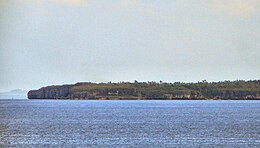
The island has an elongated elliptical shape, about 6.8 kilometres (4.2 mi) long (N-S) and 2.5 kilometres (1.6 mi) wide (E-W). Offshore are numerous coral reefs and seagrass beds. The topography of the island is hilly and along the eastern coastline is a large lagoon. The coast of the
349:
268:
A number of sinkholes have formed at various locations on the island. While one appeared in 2014, it is thought that others had developed some years earlier. As from August 2014 their cause is still being assessed.
245:, is an island of the province of Cebu in the Philippines. It lies about 25 kilometres (16 miles) off the west coast of Cebu and 12 kilometres (7 mi) northeast from
463:
377:
487:
261:
island is dominated by numerous towering rock cliffs, which are interrupted by some flat beaches. The vegetation of the island consists of dense
279:
57:
200:
456:
355:
103:
276:, and from Santa Fe by pump boat. There is a lighthouse - LS Guintarcan - to the southeast of the island (⛯
403:
188:
449:
175:
482:
381:
262:
273:
351:
Table B - Population and Annual Growth Rates by
Province, City, and Municipality - By Region
429:
246:
180:
433:
421:
250:
205:
193:
476:
324:
166:
91:
17:
41:
294:
281:
118:
105:
254:
265:, in the interior there are also large intensive agricultural areas.
437:
404:
Coast Guard
District, Central Visayas Lightstations
224:
216:
211:
199:
187:
174:
158:
150:
142:
134:
97:
87:
82:
27:
There is also a beautiful beach namely FOREST BEACH
376:Philippine Star, Jessica J Agua (7 August 2014).
457:
8:
30:
249:. The island is within the municipality of
464:
450:
325:"Mysterious Lagoon" tourist spot
138:13.34108 km (5.15102 sq mi)
40:
29:
272:The island can be reached by ferry from
340:
316:
7:
418:
416:
46:Southern portion of Guintacan Island
64:
34:Kinatarcan / Guintarcan / Batbatan
25:
428:This article about a location in
257:: Hagdan, Kinatarkan and Langub.
420:
63:
56:
488:Central Visayas geography stubs
432:region of the Philippines is a
356:Philippine Statistics Authority
1:
348:Census of Population (2020).
436:. You can help Knowledge by
378:"DENR to re-assess sinkhole"
504:
415:
154:2.5 km (1.55 mi)
146:6.8 km (4.23 mi)
163:
51:
39:
228:540/km (1400/sq mi)
295:11.30167°N 123.89111°E
253:and comprises three
300:11.30167; 123.89111
291: /
263:tropical vegetation
220:7,208 (2015 census)
119:11.325°N 123.8917°E
115: /
36:
384:on 9 November 2014
241:and also known as
237:, also spelled as
445:
444:
232:
231:
183:(Region VII)
35:
16:(Redirected from
495:
466:
459:
452:
424:
417:
407:
406:
400:
394:
393:
391:
389:
380:. Archived from
373:
367:
366:
364:
362:
345:
328:
327:
321:
306:
305:
303:
302:
301:
296:
292:
289:
288:
287:
284:
130:
129:
127:
126:
125:
124:11.325; 123.8917
120:
116:
113:
112:
111:
108:
67:
66:
60:
44:
37:
33:
21:
18:Guintacan Island
503:
502:
498:
497:
496:
494:
493:
492:
483:Islands of Cebu
473:
472:
471:
470:
430:Central Visayas
413:
411:
410:
402:
401:
397:
387:
385:
375:
374:
370:
360:
358:
347:
346:
342:
337:
332:
331:
323:
322:
318:
313:
299:
297:
293:
290:
285:
282:
280:
278:
277:
247:Bantayan Island
181:Central Visayas
170:
123:
121:
117:
114:
109:
106:
104:
102:
101:
78:
77:
76:
75:
74:
73:
72:
68:
47:
32:
28:
23:
22:
15:
12:
11:
5:
501:
499:
491:
490:
485:
475:
474:
469:
468:
461:
454:
446:
443:
442:
425:
409:
408:
395:
368:
339:
338:
336:
333:
330:
329:
315:
314:
312:
309:
230:
229:
226:
222:
221:
218:
214:
213:
209:
208:
203:
197:
196:
191:
185:
184:
178:
172:
171:
164:
161:
160:
159:Administration
156:
155:
152:
148:
147:
144:
140:
139:
136:
132:
131:
99:
95:
94:
89:
85:
84:
80:
79:
70:
69:
62:
61:
55:
54:
53:
52:
49:
48:
45:
26:
24:
14:
13:
10:
9:
6:
4:
3:
2:
500:
489:
486:
484:
481:
480:
478:
467:
462:
460:
455:
453:
448:
447:
441:
439:
435:
431:
426:
423:
419:
414:
405:
399:
396:
383:
379:
372:
369:
357:
353:
352:
344:
341:
334:
326:
320:
317:
310:
308:
304:
275:
270:
266:
264:
258:
256:
252:
251:Santa Fe
248:
244:
240:
236:
227:
223:
219:
215:
210:
207:
204:
202:
198:
195:
192:
190:
186:
182:
179:
177:
173:
169:
168:
162:
157:
153:
149:
145:
141:
137:
133:
128:
100:
96:
93:
90:
86:
81:
59:
50:
43:
38:
19:
438:expanding it
427:
412:
398:
386:. Retrieved
382:the original
371:
359:. Retrieved
350:
343:
319:
274:Daanbantayan
271:
267:
259:
242:
238:
234:
233:
225:Pop. density
212:Demographics
201:Municipality
165:
298: /
286:123°53′28″E
167:Philippines
122: /
110:123°53′30″E
98:Coordinates
92:Visayan Sea
477:Categories
388:1 November
335:References
283:11°18′06″N
243:Guintarcan
239:Kinatarcan
235:Kinatarkan
217:Population
107:11°19′30″N
71:Kinatarkan
31:Kinatarkan
255:barangays
83:Geography
206:Santa Fe
194:Santa Fe
189:Province
88:Location
361:8 July
176:Region
143:Length
311:Notes
151:Width
434:stub
390:2014
363:2021
135:Area
307:).
479::
354:.
465:e
458:t
451:v
440:.
392:.
365:.
20:)
Text is available under the Creative Commons Attribution-ShareAlike License. Additional terms may apply.