36:
28:
2030:
92:
100:
79:, Canada. In the 1960s the Gwa'sala (Gwaʼsa̱la), the 'Nakwaxda'xw (ʼNakʼwaxdaʼx̱w) and the Kwakiutl peoples were amalgamated. Eventually the Gwa'sala-'Nakwaxda'xw Nations and the Kwakiutl First Nation separated into the two groups that are recognized by the federal government to this day. Gwa'sala-'Nakwaxda'xw Nations were forcibly relocated from their homelands to a location near Port Hardy.
108:
2029:
82:
In 2024, the Gwa'sala-'Nakwaxda'xw
Nations will have constructed a Big House, a central place to conduct traditional governance and business. The Nations have not had a Big house since the forced relocation in 1964.
1265:
939:
837:
1049:
299:
1210:
1418:
723:
460:
668:
138:
1320:
617:
562:
405:
2245:
1104:
994:
350:
193:
1465:
511:
240:
1367:
1155:
778:
888:
2098:
2238:
2068:
1511:
2495:
2231:
1904:
2048:
35:
2349:
2490:
2314:
2083:
2369:
2038:
2128:
1538:
2339:
1575:
1533:
928:
1250:
1528:
1258:
818:
771:
602:
131:
1897:
1877:
27:
1411:
1407:
1034:
280:
1195:
2429:
2279:
708:
445:
1959:
657:
123:
1305:
551:
390:
2354:
2202:
1199:
1089:
979:
877:
339:
178:
127:
1458:
500:
233:
2464:
2108:
1890:
1360:
1144:
763:
2374:
2414:
2274:
2419:
2394:
2389:
2384:
2334:
2329:
2304:
2284:
2254:
2073:
1523:
91:
17:
2359:
2324:
2289:
2197:
1097:
72:
68:
1984:
2469:
2449:
2439:
2424:
2409:
2404:
2399:
2299:
2269:
2103:
2078:
1038:
284:
2454:
2444:
2434:
2379:
2207:
2093:
2088:
2004:
822:
555:
394:
186:
1969:
1148:
2364:
2319:
1093:
1042:
449:
288:
1964:
2344:
2063:
1954:
1949:
343:
2459:
2223:
1974:
983:
1994:
1979:
1944:
1309:
99:
2309:
2053:
2014:
2258:
2113:
1913:
716:
606:
398:
76:
60:
56:
48:
2171:
2294:
2118:
2019:
1203:
881:
826:
610:
116:
52:
712:
2484:
2151:
1999:
1254:
987:
830:
504:
182:
1929:
1862:
1851:
1840:
1829:
1817:
1806:
1795:
1784:
1773:
1762:
1751:
1740:
1729:
1718:
1707:
1696:
1685:
1674:
1663:
1652:
1641:
1630:
1619:
1608:
1597:
1586:
1934:
932:
767:
661:
453:
292:
2212:
1555:
1989:
1461:, on the south shore of Smith Sound at the entrance to Wyclees Lagoon, 223 ha.
2141:
2009:
1939:
1313:
64:
1481:
1467:
1434:
1420:
1383:
1369:
1336:
1322:
1281:
1267:
1226:
1212:
1171:
1157:
1120:
1106:
1065:
1051:
1010:
996:
955:
941:
904:
890:
853:
839:
794:
780:
739:
725:
684:
670:
633:
619:
578:
564:
527:
513:
476:
462:
421:
407:
366:
352:
315:
301:
256:
242:
209:
195:
154:
140:
2136:
2161:
2192:
2166:
2146:
1576:
Indian and
Northern Affairs Canada "Reserves/Settlements/Villages Detail"
236:, at the mouth of Smokehouse Creek at the head of Long Lake, 3.60 ha.
107:
2176:
2156:
106:
98:
90:
34:
26:
1882:
2227:
1886:
1818:
BC Names/GeoBC entry "Tseetsum-Sawlasilah 6 (Indian reserve)
1730:
BC Names/GeoBC entry "Owh-wis-too-a-wan 10 (Indian reserve)"
1752:
BC Names/GeoBC entry "Pel-looth'l Kai 17 (Indian reserve)"
1363:, at the head of Allison Sound, Belize Inlet, 37.60 ha.
1774:
1620:
BC Names/GeoBC entry "Kai-too-kwis 15 (Indian reserve)"
711:, comprising Indian Island and five smaller islands in
119:
under the governance of the Gwa'sala-'Nakwaxda'xw are:
1807:
BC Names/GeoBC entry "Tsai-kwi-ee 13 (Indian reserve)"
1414:, two miles from the head of Seymour Inlet, 66.80 ha.
1653:
BC Names/GeoBC entry "Ko-kwi-iss 14 (Indian reserve)"
1697:
BC Names/GeoBC entry "Na-kwockto 2 (Indian reserve)"
2185:
2127:
2037:
1922:
1852:
BC Names/GeoBC entry "Wawwat'l 12 (Indian reserve)"
1830:
BC Names/GeoBC entry "Tsulquate 4 (Indian reserve)"
1686:
BC Names/GeoBC entry "Mahpahkum 4 (Indian reserve)"
1675:
BC Names/GeoBC entry "Kwetahkis 9 (Indian reserve)"
1642:
BC Names/GeoBC entry "Khazisela 7 (Indian reserve)"
1598:
BC Names/GeoBC entry "Dedeguahs 8 (Indian reserve)"
63:, whose main reserve community is near the town of
1785:BC Names/GeoBC entry "Ta-a-ack 5 (Indian reserve)"
1763:BC Names/GeoBC entry "Peneece 11 (Indian reserve)"
1631:BC Names/GeoBC entry "Kequesta 1 (Indian reserve)"
613:, and including small off-shore islands, 7.80 ha.
1863:BC Names/GeoBC entry "Wyclese 1 (Indian reserve)"
1664:BC Names/GeoBC entry "Kuthlo 18 (Indian reserve)"
1609:BC Names/GeoBC entry "Halowis 5 (Indian reserve)"
664:, 1/2 mile south of Kequesta IR No. 1, 0.40 ha.
1841:BC Names/GeoBC entry "Waump 16 (Indian reserve)"
1796:BC Names/GeoBC entry "Toksee 4 (Indian Reserve)"
1719:BC Names/GeoBC entry "Nekite 2 (Indian reserve)"
1741:BC Names/GeoBC entry "Pahas 3 (Indian reserve)"
2239:
1898:
8:
18:Gwa'sala-'Nakwaxda'xw Nation
2246:
2232:
2224:
1905:
1891:
1883:
1587:BC Names/GeoBC entry "Ann Island IR No. 7"
2099:Mamalilikulla-QweʼQwaʼSotʼEm First Nation
2049:Campbell River First Nation (Wei Wai Kum)
660:, on three small islands at the mouth of
342:, on the north shore of the entrance to
2350:Kwicksutaineuk-ah-kwa-mish First Nation
1568:
2054:Cape Mudge First Nation (Wei Wai Kai)
7:
393:, on an island in the centre of the
1147:, at the junction of Long Lake and
25:
2496:Central Coast of British Columbia
2370:Mowachaht/Muchalaht First Nations
2340:Kyuquot/Cheklesahht First Nation
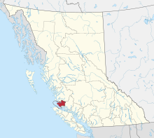
31:Gwa'sala-'Nakwaxda'xw Territories
2028:
1708:"Nathlegalis 3 (Indian reserve)"
1092:, on one of the islands in the
503:, at the head of Salmon Arm of
95:Totem pole within the community
1878:BC Treaty.net information page
1:
2084:Daʼnaxdaʼxw Awaetlatla Nation
2059:Gwaʼsala-ʼNakwaxdaʼxw Nations
111:'Nakwaxda'xw Chief's Daughter
2315:Gwa'sala-'Nakwaxda'xw Nation
2064:Kʼómoks (Comox) First Nation
1293:Tseetsum-Sawlasilah IR No. 6
1251:Tseetsum-Sawlasilah IR No. 6
45:Gwa'sala-Nakwaxda'xw Nations
2430:Tla-o-qui-aht First Nations
2280:Campbell River First Nation
1539:GPX (secondary coordinates)
1410:, on the right bank of the
865:Owh-wis-too-a-wan IR No. 10
819:Owh-wis-too-a-wan IR No. 10
47:are an amalgamation of two
2512:
2355:Lake Cowichan First Nation
558:on Seymour Inlet, 4.0 ha.
2491:Kwakwaka'wakw governments
2465:Uchucklesaht First Nation
2265:
2109:Tsawataineuk First Nation
2069:Kwikwasutʼinuxw Haxwaʼmis
2026:
1534:GPX (primary coordinates)
1509:Map all coordinates using
967:Pel-looth'l Kai IR No. 17
929:Pel-looth'l Kai IR No. 17
2275:Beecher Bay First Nation
1517:Download coordinates as:
1253:, on the north shore of
880:, on the north shore of
554:, on the north shore of
185:, 1/2 mile north of the
181:, on the north shore of
2420:Snuneymuxw First Nation
2395:Pauquachin First Nation
2390:Pacheedaht First Nation
2385:Nuchatlaht First Nation
2335:Huu-ay-aht First Nation
2330:Hupacasath First Nation
2305:Ehattesaht First Nation
2285:Cape Mudge First Nation
1308:, on the west shore of
1037:, on the east shore of
448:, on the east shore of
2360:Lyackson First Nations
2325:Hesquiaht First Nation
2290:Chemainus First Nation
1482:51.28333°N 127.35000°W
1435:51.21667°N 126.66667°W
1384:51.18333°N 126.91667°W
1337:50.73333°N 127.50000°W
1282:51.33333°N 127.31667°W
1227:51.16667°N 127.41667°W
1172:51.23333°N 127.33333°W
1121:51.03333°N 127.71667°W
1098:Queen Charlotte Strait
1077:Saagoombahlah IR No. 6
1066:51.08333°N 127.51667°W
1035:Saagoombahlah IR No. 6
1011:51.11667°N 126.70000°W
986:on the north shore of
956:51.11667°N 126.91667°W
905:50.90000°N 127.30000°W
854:51.08333°N 126.76667°W
795:51.41667°N 127.08333°W
766:, at the mouth of the
740:51.28333°N 127.65000°W
685:51.08333°N 127.46667°W
634:50.88333°N 127.46667°W
579:50.96667°N 127.21667°W
528:51.06667°N 126.65000°W
477:51.15000°N 127.10000°W
422:51.10000°N 127.51667°W
367:51.10000°N 127.46667°W
327:Kai-too-kwis IR No. 15
316:51.18333°N 127.08333°W
281:Kai-too-kwis IR No. 15
257:51.30000°N 127.05000°W
210:51.10000°N 127.51667°W
155:51.26667°N 127.80000°W
112:
104:
96:
87:First Nations reserves
69:Queen Charlotte Strait
40:
32:
2470:Ucluelet First Nation
2450:Tseshaht First Nation
2440:Tsartlip First Nation
2425:Songhees First Nation
2415:Scia'new First Nation
2410:Quatsino First Nation
2405:Qualicum First Nation
2400:Penelakut Indian Band
2300:Ditidaht First Nation
2270:Ahousaht First Nation
2186:Culture & Society
2104:Kwakiutl First Nation
2079:Quatsino First Nation
1529:GPX (all coordinates)
1238:Tsai-kwi-ee IR No. 13
1202:on the east shore of
1196:Tsai-kwi-ee IR No. 13
931:, at the east end of
110:
102:
94:
38:
30:
2455:Tseycum First Nation
2445:Tsawout First Nation
2435:Toquaht First Nation
2380:Nanoose First Nation
2375:‘Namgis First Nation
2094:Kwiakah First Nation
2089:Tlatlasikwala Nation
2074:ʼNamgis First Nation
1487:51.28333; -127.35000
1440:51.21667; -126.66667
1389:51.18333; -126.91667
1342:50.73333; -127.50000
1312:, one mile north of
1287:51.33333; -127.31667
1232:51.16667; -127.41667
1177:51.23333; -127.33333
1126:51.03333; -127.71667
1071:51.08333; -127.51667
1016:51.11667; -126.70000
961:51.11667; -126.91667
910:50.90000; -127.30000
859:51.08333; -126.76667
800:51.41667; -127.08333
751:Nathlegalis IR No. 3
745:51.28333; -127.65000
709:Nathlegalis IR No. 3
690:51.08333; -127.46667
639:50.88333; -127.46667
584:50.96667; -127.21667
533:51.06667; -126.65000
488:Ko-kwi-iss IR No. 14
482:51.15000; -127.10000
446:Ko-kwi-iss IR No. 14
427:51.10000; -127.51667
397:at the north end of
372:51.10000; -127.46667
321:51.18333; -127.08333
262:51.30000; -127.05000
215:51.10000; -127.51667
160:51.26667; -127.80000
73:Central Coast region
2365:Malahat Indian Band
2320:Halalt First Nation
1477: /
1430: /
1379: /
1332: /
1277: /
1222: /
1167: /
1116: /
1096:at the west end of
1061: /
1006: /
951: /
900: /
849: /
790: /
735: /
696:Na-kwockto IR No. 2
680: /
658:Na-kwockto IR No. 2
629: /
574: /
523: /
472: /
417: /
362: /
311: /
252: /
205: /
166:Ann Island IR No. 7
150: /
124:Ann Island IR No. 7
2345:Comox First Nation
1446:Wawwat'l IR No. 12
1348:Tsulquate IR No. 4
1306:Tsulquate IR No. 4
645:Mahpahkum IR No. 4
603:Mahpahkum IR No. 4
590:Kwetahkis IR No. 9
552:Kwetahkis IR No. 9
433:Khazisela IR No. 7
391:Khazisela IR No. 7
113:
105:
97:
55:based on northern
41:
39:'Nakwaxda'xw Chief
33:
2478:
2477:
2310:Esquimault Nation
2221:
2220:
1923:Tribes or Nations
1502:
1455:
1408:Wawwat'l IR No 12
1404:
1357:
1302:
1247:
1192:
1141:
1132:Ta-a-ack IR No. 5
1090:Ta-a-ack IR No. 5
1086:
1031:
1022:Peneece IR No. 11
982:, at the head of
980:Peneece IR No. 11
976:
925:
874:
815:
760:
705:
654:
599:
548:
497:
442:
387:
378:Kequesta IR No. 1
340:Kequesta IR No. 1
336:
283:, at the head of
277:
230:
221:Dedegaus IR No. 8
179:Dedagaus IR No. 8
175:
16:(Redirected from
2503:
2259:Vancouver Island
2248:
2241:
2234:
2225:
2114:Tlowitsis Nation
2041:
2032:
1916:
1907:
1900:
1893:
1884:
1865:
1860:
1854:
1849:
1843:
1838:
1832:
1827:
1821:
1815:
1809:
1804:
1798:
1793:
1787:
1782:
1776:
1771:
1765:
1760:
1754:
1749:
1743:
1738:
1732:
1727:
1721:
1716:
1710:
1705:
1699:
1694:
1688:
1683:
1677:
1672:
1666:
1661:
1655:
1650:
1644:
1639:
1633:
1628:
1622:
1617:
1611:
1606:
1600:
1595:
1589:
1584:
1578:
1573:
1501:
1500:
1498:
1497:
1496:
1494:
1493:Wyclese IR No. 1
1489:
1488:
1483:
1478:
1475:
1474:
1473:
1470:
1462:
1459:Wyclese IR No. 1
1454:
1453:
1451:
1450:
1449:
1447:
1442:
1441:
1436:
1431:
1428:
1427:
1426:
1423:
1415:
1403:
1402:
1400:
1399:
1398:
1396:
1391:
1390:
1385:
1380:
1377:
1376:
1375:
1372:
1364:
1356:
1355:
1353:
1352:
1351:
1349:
1344:
1343:
1338:
1333:
1330:
1329:
1328:
1325:
1317:
1301:
1300:
1298:
1297:
1296:
1294:
1289:
1288:
1283:
1278:
1275:
1274:
1273:
1270:
1262:
1246:
1245:
1243:
1242:
1241:
1239:
1234:
1233:
1228:
1223:
1220:
1219:
1218:
1215:
1207:
1191:
1190:
1188:
1187:
1186:
1184:
1179:
1178:
1173:
1168:
1165:
1164:
1163:
1160:
1152:
1140:
1139:
1137:
1136:
1135:
1133:
1128:
1127:
1122:
1117:
1114:
1113:
1112:
1109:
1101:
1085:
1084:
1082:
1081:
1080:
1078:
1073:
1072:
1067:
1062:
1059:
1058:
1057:
1054:
1046:
1039:Schooner Passage
1030:
1029:
1027:
1026:
1025:
1023:
1018:
1017:
1012:
1007:
1004:
1003:
1002:
999:
991:
975:
974:
972:
971:
970:
968:
963:
962:
957:
952:
949:
948:
947:
944:
936:
924:
923:
921:
920:
919:
917:
912:
911:
906:
901:
898:
897:
896:
893:
885:
873:
872:
870:
869:
868:
866:
861:
860:
855:
850:
847:
846:
845:
842:
834:
825:at the mouth of
814:
813:
811:
810:
809:
807:
802:
801:
796:
791:
788:
787:
786:
783:
775:
759:
758:
756:
755:
754:
752:
747:
746:
741:
736:
733:
732:
731:
728:
720:
717:Browning Channel
704:
703:
701:
700:
699:
697:
692:
691:
686:
681:
678:
677:
676:
673:
665:
653:
652:
650:
649:
648:
646:
641:
640:
635:
630:
627:
626:
625:
622:
614:
607:Deserters Island
598:
597:
595:
594:
593:
591:
586:
585:
580:
575:
572:
571:
570:
567:
559:
547:
546:
544:
543:
542:
540:
539:Kuthlo IR No. 18
535:
534:
529:
524:
521:
520:
519:
516:
508:
501:Kuthlo IR No. 18
496:
495:
493:
492:
491:
489:
484:
483:
478:
473:
470:
469:
468:
465:
457:
452:to the north of
441:
440:
438:
437:
436:
434:
429:
428:
423:
418:
415:
414:
413:
410:
402:
399:Schooner Channel
386:
385:
383:
382:
381:
379:
374:
373:
368:
363:
360:
359:
358:
355:
347:
335:
334:
332:
331:
330:
328:
323:
322:
317:
312:
309:
308:
307:
304:
296:
285:Chief Nollis Bay
276:
275:
273:
272:
271:
269:
268:Halowis IR No. 5
264:
263:
258:
253:
250:
249:
248:
245:
237:
234:Halowis IR No. 5
229:
228:
226:
225:
224:
222:
217:
216:
211:
206:
203:
202:
201:
198:
190:
174:
173:
171:
170:
169:
167:
162:
161:
156:
151:
148:
147:
146:
143:
135:
77:British Columbia
61:British Columbia
57:Vancouver Island
21:
2511:
2510:
2506:
2505:
2504:
2502:
2501:
2500:
2481:
2480:
2479:
2474:
2460:T'sou-ke Nation
2295:Cowichan Tribes
2261:
2257:governments on
2252:
2222:
2217:
2181:
2123:
2119:Gwawaenuk Tribe
2039:
2033:
2024:
2020:Laich-kwil-tach
2005:Tʼlatʼlasikwala
1918:
1914:
1911:
1874:
1869:
1868:
1861:
1857:
1850:
1846:
1839:
1835:
1828:
1824:
1816:
1812:
1805:
1801:
1794:
1790:
1783:
1779:
1772:
1768:
1761:
1757:
1750:
1746:
1739:
1735:
1728:
1724:
1717:
1713:
1706:
1702:
1695:
1691:
1684:
1680:
1673:
1669:
1662:
1658:
1651:
1647:
1640:
1636:
1629:
1625:
1618:
1614:
1607:
1603:
1596:
1592:
1585:
1581:
1574:
1570:
1565:
1552:
1547:
1546:
1545:
1544:
1543:
1492:
1490:
1486:
1484:
1480:
1479:
1476:
1471:
1468:
1466:
1464:
1463:
1445:
1443:
1439:
1437:
1433:
1432:
1429:
1424:
1421:
1419:
1417:
1416:
1395:Waump IR No. 16
1394:
1392:
1388:
1386:
1382:
1381:
1378:
1373:
1370:
1368:
1366:
1365:
1361:Waump IR No. 16
1347:
1345:
1341:
1339:
1335:
1334:
1331:
1326:
1323:
1321:
1319:
1318:
1292:
1290:
1286:
1284:
1280:
1279:
1276:
1271:
1268:
1266:
1264:
1263:
1237:
1235:
1231:
1229:
1225:
1224:
1221:
1216:
1213:
1211:
1209:
1208:
1204:Mereworth Sound
1183:Toksee IR No. 4
1182:
1180:
1176:
1174:
1170:
1169:
1166:
1161:
1158:
1156:
1154:
1153:
1145:Toksee IR No. 4
1131:
1129:
1125:
1123:
1119:
1118:
1115:
1110:
1107:
1105:
1103:
1102:
1076:
1074:
1070:
1068:
1064:
1063:
1060:
1055:
1052:
1050:
1048:
1047:
1021:
1019:
1015:
1013:
1009:
1008:
1005:
1000:
997:
995:
993:
992:
966:
964:
960:
958:
954:
953:
950:
945:
942:
940:
938:
937:
915:
913:
909:
907:
903:
902:
899:
894:
891:
889:
887:
886:
882:Blunden Harbour
864:
862:
858:
856:
852:
851:
848:
843:
840:
838:
836:
835:
827:Frederick Sound
823:Eclipse Narrows
806:Nekite IR No. 2
805:
803:
799:
797:
793:
792:
789:
784:
781:
779:
777:
776:
770:at the head of
764:Nekite IR No. 2
750:
748:
744:
742:
738:
737:
734:
729:
726:
724:
722:
721:
695:
693:
689:
687:
683:
682:
679:
674:
671:
669:
667:
666:
644:
642:
638:
636:
632:
631:
628:
623:
620:
618:
616:
615:
611:Deserters Group
589:
587:
583:
581:
577:
576:
573:
568:
565:
563:
561:
560:
556:Whelakis Lagoon
538:
536:
532:
530:
526:
525:
522:
517:
514:
512:
510:
509:
487:
485:
481:
479:
475:
474:
471:
466:
463:
461:
459:
458:
432:
430:
426:
424:
420:
419:
416:
411:
408:
406:
404:
403:
395:Nahkwocto Raids
377:
375:
371:
369:
365:
364:
361:
356:
353:
351:
349:
348:
326:
324:
320:
318:
314:
313:
310:
305:
302:
300:
298:
297:
267:
265:
261:
259:
255:
254:
251:
246:
243:
241:
239:
238:
220:
218:
214:
212:
208:
207:
204:
199:
196:
194:
192:
191:
187:Nahwokto Rapids
165:
163:
159:
157:
153:
152:
149:
144:
141:
139:
137:
136:
103:Gwa'sala beater
89:
53:band government
23:
22:
15:
12:
11:
5:
2509:
2507:
2499:
2498:
2493:
2483:
2482:
2476:
2475:
2473:
2472:
2467:
2462:
2457:
2452:
2447:
2442:
2437:
2432:
2427:
2422:
2417:
2412:
2407:
2402:
2397:
2392:
2387:
2382:
2377:
2372:
2367:
2362:
2357:
2352:
2347:
2342:
2337:
2332:
2327:
2322:
2317:
2312:
2307:
2302:
2297:
2292:
2287:
2282:
2277:
2272:
2266:
2263:
2262:
2253:
2251:
2250:
2243:
2236:
2228:
2219:
2218:
2216:
2215:
2210:
2205:
2200:
2195:
2189:
2187:
2183:
2182:
2180:
2179:
2174:
2169:
2164:
2159:
2154:
2149:
2144:
2139:
2133:
2131:
2125:
2124:
2122:
2121:
2116:
2111:
2106:
2101:
2096:
2091:
2086:
2081:
2076:
2071:
2066:
2061:
2056:
2051:
2045:
2043:
2035:
2034:
2027:
2025:
2023:
2022:
2017:
2012:
2007:
2002:
1997:
1992:
1987:
1982:
1977:
1972:
1970:Kwikwasutʼinux
1967:
1962:
1957:
1952:
1947:
1942:
1937:
1932:
1926:
1924:
1920:
1919:
1912:
1910:
1909:
1902:
1895:
1887:
1881:
1880:
1873:
1872:External links
1870:
1867:
1866:
1855:
1844:
1833:
1822:
1810:
1799:
1788:
1777:
1766:
1755:
1744:
1733:
1722:
1711:
1700:
1689:
1678:
1667:
1656:
1645:
1634:
1623:
1612:
1601:
1590:
1579:
1567:
1566:
1564:
1561:
1560:
1559:
1551:
1548:
1542:
1541:
1536:
1531:
1526:
1520:
1514:
1507:
1506:
1505:
1504:
1503:
1456:
1405:
1358:
1303:
1248:
1193:
1149:Wyclees Lagoon
1142:
1087:
1032:
977:
926:
916:Pahas IR No. 3
878:Pahas IR No. 3
875:
816:
761:
713:Takush Harbour
706:
655:
600:
549:
498:
443:
388:
337:
278:
231:
176:
115:First Nations
88:
85:
71:region of the
24:
14:
13:
10:
9:
6:
4:
3:
2:
2508:
2497:
2494:
2492:
2489:
2488:
2486:
2471:
2468:
2466:
2463:
2461:
2458:
2456:
2453:
2451:
2448:
2446:
2443:
2441:
2438:
2436:
2433:
2431:
2428:
2426:
2423:
2421:
2418:
2416:
2413:
2411:
2408:
2406:
2403:
2401:
2398:
2396:
2393:
2391:
2388:
2386:
2383:
2381:
2378:
2376:
2373:
2371:
2368:
2366:
2363:
2361:
2358:
2356:
2353:
2351:
2348:
2346:
2343:
2341:
2338:
2336:
2333:
2331:
2328:
2326:
2323:
2321:
2318:
2316:
2313:
2311:
2308:
2306:
2303:
2301:
2298:
2296:
2293:
2291:
2288:
2286:
2283:
2281:
2278:
2276:
2273:
2271:
2268:
2267:
2264:
2260:
2256:
2255:First Nations
2249:
2244:
2242:
2237:
2235:
2230:
2229:
2226:
2214:
2211:
2209:
2206:
2204:
2201:
2199:
2196:
2194:
2191:
2190:
2188:
2184:
2178:
2175:
2173:
2170:
2168:
2165:
2163:
2160:
2158:
2155:
2153:
2152:New Vancouver
2150:
2148:
2145:
2143:
2140:
2138:
2135:
2134:
2132:
2130:
2126:
2120:
2117:
2115:
2112:
2110:
2107:
2105:
2102:
2100:
2097:
2095:
2092:
2090:
2087:
2085:
2082:
2080:
2077:
2075:
2072:
2070:
2067:
2065:
2062:
2060:
2057:
2055:
2052:
2050:
2047:
2046:
2044:
2042:
2040:First Nations
2036:
2031:
2021:
2018:
2016:
2013:
2011:
2008:
2006:
2003:
2001:
1998:
1996:
1993:
1991:
1988:
1986:
1985:ʼNakʼwaxdaʼxw
1983:
1981:
1978:
1976:
1973:
1971:
1968:
1966:
1963:
1961:
1958:
1956:
1953:
1951:
1948:
1946:
1943:
1941:
1938:
1936:
1933:
1931:
1928:
1927:
1925:
1921:
1917:
1915:Kwakwakaʼwakw
1908:
1903:
1901:
1896:
1894:
1889:
1888:
1885:
1879:
1876:
1875:
1871:
1864:
1859:
1856:
1853:
1848:
1845:
1842:
1837:
1834:
1831:
1826:
1823:
1819:
1814:
1811:
1808:
1803:
1800:
1797:
1792:
1789:
1786:
1781:
1778:
1775:
1770:
1767:
1764:
1759:
1756:
1753:
1748:
1745:
1742:
1737:
1734:
1731:
1726:
1723:
1720:
1715:
1712:
1709:
1704:
1701:
1698:
1693:
1690:
1687:
1682:
1679:
1676:
1671:
1668:
1665:
1660:
1657:
1654:
1649:
1646:
1643:
1638:
1635:
1632:
1627:
1624:
1621:
1616:
1613:
1610:
1605:
1602:
1599:
1594:
1591:
1588:
1583:
1580:
1577:
1572:
1569:
1562:
1557:
1554:
1553:
1549:
1540:
1537:
1535:
1532:
1530:
1527:
1525:
1522:
1521:
1519:
1518:
1513:
1512:OpenStreetMap
1510:
1499:
1460:
1457:
1452:
1413:
1412:Seymour River
1409:
1406:
1401:
1362:
1359:
1354:
1315:
1311:
1307:
1304:
1299:
1260:
1256:
1255:Naysash Inlet
1252:
1249:
1244:
1205:
1201:
1197:
1194:
1189:
1150:
1146:
1143:
1138:
1099:
1095:
1094:Storm Islands
1091:
1088:
1083:
1044:
1043:Braham Island
1040:
1036:
1033:
1028:
989:
988:Seymour Inlet
985:
981:
978:
973:
934:
930:
927:
922:
883:
879:
876:
871:
832:
831:Seymour Inlet
828:
824:
820:
817:
812:
774:, 66.80 ha.
773:
769:
765:
762:
757:
719:, 134.40 ha.
718:
714:
710:
707:
702:
663:
659:
656:
651:
612:
608:
604:
601:
596:
557:
553:
550:
545:
506:
505:Seymour Inlet
502:
499:
494:
455:
451:
450:Allison Sound
447:
444:
439:
400:
396:
392:
389:
384:
345:
341:
338:
333:
294:
290:
289:Allison Sound
286:
282:
279:
274:
235:
232:
227:
188:
184:
183:Seymour Inlet
180:
177:
172:
133:
129:
125:
122:
121:
120:
118:
109:
101:
93:
86:
84:
80:
78:
74:
70:
66:
62:
58:
54:
51:peoples in a
50:
49:Kwakwaka'wakw
46:
37:
29:
19:
2058:
1965:Dzawadaʼenux
1935:Mamalilikala
1858:
1847:
1836:
1825:
1813:
1802:
1791:
1780:
1769:
1758:
1747:
1736:
1725:
1714:
1703:
1692:
1681:
1670:
1659:
1648:
1637:
1626:
1615:
1604:
1593:
1582:
1571:
1516:
1515:
1508:
1316:, 59.90 ha.
1100:, 13.90 ha.
933:Belize Inlet
884:, 39.90 ha.
768:Nekite River
662:Nugent Sound
454:Belize Inlet
346:, 70.40 ha.
295:, 20.80 ha.
293:Belize Inlet
134:, 10.10 ha.
114:
81:
44:
42:
1960:Maʼamtagila
1955:Daʼnaxdaʼxw
1950:Aʼwaʼetʼala
1485: /
1472:127°21′00″W
1438: /
1425:126°40′00″W
1387: /
1374:126°55′00″W
1340: /
1327:127°30′00″W
1285: /
1272:127°19′00″W
1261:, 2.10 ha.
1259:Smith Sound
1230: /
1217:127°25′00″W
1206:, 4.60 ha.
1200:Village Bay
1175: /
1162:127°20′00″W
1151:, 5.60 ha.
1124: /
1111:127°43′00″W
1069: /
1056:127°31′00″W
1045:, 1.80 ha.
1014: /
1001:126°42′00″W
990:, 3.50 ha.
959: /
946:126°55′00″W
935:, 1.70 ha.
908: /
895:127°18′00″W
857: /
844:126°46′00″W
833:, 5.30 ha.
798: /
785:127°05′00″W
772:Smith Inlet
743: /
730:127°39′00″W
688: /
675:127°28′00″W
637: /
624:127°28′00″W
582: /
569:127°13′00″W
531: /
518:126°39′00″W
480: /
467:127°06′00″W
456:, 6.40 ha.
425: /
412:127°31′00″W
401:, 0.40 ha.
370: /
357:127°28′00″W
344:Nuget Sound
319: /
306:127°05′00″W
291:, north of
260: /
247:127°03′00″W
213: /
200:127°31′00″W
189:, 0.30 ha.
158: /
145:127°48′00″W
132:Smith Sound
2485:Categories
2142:Gwayasdums
2000:Gwatʼsinux
1975:Gwawaʼenux
1563:References
1558:(language)
1491: (
1469:51°17′00″N
1444: (
1422:51°13′00″N
1393: (
1371:51°11′00″N
1346: (
1324:50°44′00″N
1314:Port Hardy
1291: (
1269:51°20′00″N
1236: (
1214:51°10′00″N
1181: (
1159:51°14′00″N
1130: (
1108:51°02′00″N
1075: (
1053:51°05′00″N
1020: (
998:51°07′00″N
984:Wigwam Bay
965: (
943:51°07′00″N
914: (
892:50°54′00″N
863: (
841:51°05′00″N
804: (
782:51°25′00″N
749: (
727:51°17′00″N
694: (
672:51°05′00″N
643: (
621:50°53′00″N
588: (
566:50°58′00″N
537: (
515:51°04′00″N
507:, 3.0 ha.
486: (
464:51°09′00″N
431: (
409:51°06′00″N
376: (
354:51°06′00″N
325: (
303:51°11′00″N
266: (
244:51°18′00″N
219: (
197:51°06′00″N
164: (
142:51°16′00″N
128:Ann Island
65:Port Hardy
2213:Kwakʼwala
2203:Mythology
2137:Memkumlis
1995:Gusgimukw
1980:Haxwaʼmis
1945:Ławitʼsis
1556:Kwak'wala
1310:Hardy Bay
2193:Potlatch
2147:Kalugwis
2129:Villages
1990:Gwaʼsala
1550:See also
1041:east of
117:reserves
2015:Wiwekam
2010:Wekaʼyi
1940:ʼNamgis
1930:Kwaguʼł
609:in the
67:in the
2177:Tsaxis
2162:Gwaʼyi
2198:Music
2172:Takus
2167:Baʼas
2157:Yalis
1198:, at
821:, at
605:, on
126:, on
43:The
2208:Art
1524:KML
715:in
287:on
130:in
75:of
59:in
2487::
1257:,
829:,
2247:e
2240:t
2233:v
1906:e
1899:t
1892:v
1820:"
1495:)
1448:)
1397:)
1350:)
1295:)
1240:)
1185:)
1134:)
1079:)
1024:)
969:)
918:)
867:)
808:)
753:)
698:)
647:)
592:)
541:)
490:)
435:)
380:)
329:)
270:)
223:)
168:)
20:)
Text is available under the Creative Commons Attribution-ShareAlike License. Additional terms may apply.