474:
81:
352:
360:
157:
224:
22:
1263:
30:
299:. This has largely been done for aesthetic reasons, i.e. to produce variety and to reduce the hard lines produced by conifers. However, commercial reasons will always dictate the need for faster-growing conifers. These have a plant-harvest cycle of between 20 and 40 years (depending on type), whereas oak requires the best part of a century.
437:
Mention has already been made of the numerous lakes in the forest, and indeed in this central area they were all, almost without exception, created or enlarged to provide reservoirs for the mine workings. In most cases water was run from these via leats, which turned water-wheels to power machinery
338:
Whilst the forest has to be accessible to forest workers' vehicles (there are over 100 miles (160 km) of roads and tracks in the forest), it is not open to private vehicles except on designated Open Days. However, there are a number of forest car parks and most of these have picnic sites. The
376:
were mined, and the heyday of metal mining in the forest was between 1850 and 1919, although mining on a small scale began in the early 17th century. Indeed, whilst evidence is difficult to find following centuries of subsequent mining work, it is more than likely that a certain amount of shallow
319:
amounts to just over 12%, and of the four forest areas, the Gwydir Forest is probably the most popular based on visitor numbers. In 1937, Gwydir was designated a
National Forest Park, and since 1993 the heartland of the forest has been accorded the special status of Forest Park. Promotion as an
302:
The forest still gives direct employment to 75 people, and creates local work for many others. It is estimated that the forest is growing at a rate of 125 tons a day, and is naturally being harvested at much the same rate. At times rights of way in the forest may be closed or restricted where
367:
Today the forest is dotted with the remains of former metal mines: old engine houses, waste tips, reservoirs, and the surface remains of the pits themselves. This, however, is nothing compared to the labyrinth of tunnels below the surface, which run to many miles in length. Predominantly
251:
had highlighted a shortage in wood production, and left the area with little natural woodland. Many of the early planters and forestry workers had no experience of forestry, being formerly employed in the forest's mines, and many anecdotes from this era can be found in the book
35:
32:
31:
149:
The forested areas occupy the steep slopes and poorer soils of the plateau, the best of the soil being in the agricultural valley bottoms. Rainfall in the forest varies from under 50 inches (1,300 mm) to over 80 inches (2,000 mm) p.a.
441:
On acquisition of the land by the then
Forestry Commission, efforts were made to make former mine workings safe, and before increased public access further extensive works were carried out by the National Park Authority, with funding from the
418:
it was the only mine to be still working. It reopened in 1950, and it produced more lead and zinc ore between 1953 and 1957 than the whole of the
Llanrwst area in the century from 1848. Despite some subsequent modernisation it closed down in
256:. Millions of seedlings were grown in the Diosgydd nursery, and the first areas planted were those that previously had some coverage. Most of the original plantations have now been felled and replanted as part of the forestry cycle.
429:
The first four of the mines listed above have been linked by the "Miners Trail", a circular route marked with information boards. Their remains can also easily be seen from the unclassified road that runs from Gwydir Castle (on the
34:
323:
The forest is very accessible by wide tracks, old miners' paths, and long-established forest walks, a number of which follow waymarked routes. This popularity has further increased in recent years after the construction of the
103:
Certainly there would have been a certain amount of natural tree growth on these hills thousands of years ago. More recently, records from the 18th century refer to the rafting of timber down the
458:. Given the opportunities that the wealth of tunnels below the mines offers, it is hoped that future identification of safe areas will allow the re-opening of some areas for limited access.
512:) was found hibernating in a disused mine in the forest, the furthest north in the UK that this species had been found. The bat had been ringed as a juvenile in 1999 in the Forest of Dean.
153:
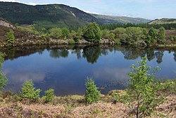
The forest is home to numerous lakes, all of which are reachable by footpaths, and nearly all of which were created to serve the mines of the Forest. In order of size, these include:
72:
uses the alternative spelling (i.e. Gwydyr Forest, Coedwig Gwydyr). Certainly as early as 1536, Leland wrote: "Gwydir lieth two bowshots above the River Conwy. It is a pretty place."
1346:
489:, being found only around old metal workings. They are able to extract minerals from the rock that would kill other species. Principal species found on the Gwydir mine sites are
1351:
33:
481:
The piles of rock waste on the former mine sites have proved to be ideal breeding grounds for rare plants, and have resulted in the designation of part of the forest as a
118:
The forest occupies an undulating plateau, reaching to between 700 and 1,000 feet (210 and 300 m) above sea level, which is divided by the valleys of the rivers
414:
Parc Mine was the largest and most successful of these mines. It opened in 1855 as the Gwydyr Park
Consols and was worked intermittently up to the 1940s. By
1356:
335:), a competition-standard mountain bike route, which is approximately 28 kilometres (17 mi) long with 860 metres (2,820 ft) of climbing in all.
666:
134:. Despite being a forest, much of it is not dark and enclosed, and it offers fine views over these valleys, with further views to the mountains of the
100:. It covers an area of over 72.5 square kilometres (28.0 sq mi), including 49 square kilometres (19 sq mi) of productive woodland.
708:
482:
1282:
473:
661:
359:
80:
1241:
557:
596:
1093:
533:
500:
The capping of the mine shafts for safety reasons has resulted in an ideal environment for bats, and the designation of a
447:
1221:
501:
455:
676:
351:
1200:
519:
in north Wales in the last decade, and pine marten DNA was recovered from a dropping found in Gwydir Forest in 1996.
283:), relatively suited to the area's poor, shallow soils, but recent years have seen the increased planting of native
243:
of 1919, Gwydir Forest was established by the
Forestry Commission in 1921, after much of the land was acquired from
1246:
1231:
985:
701:
304:
59:
645:(a series of 7 books), by John Bennett & Robert W. Vernon (published by Gwydir Mines Publications, 1989–1997).
1226:
39:
Aerial vieo of Gwydir Forest reservoirs, including: Llyn Cyfty, Llyn Sarnau, Llyn
Goddionduon and Llyn Tynymynydd
1236:
443:
622:
1185:
1144:
1078:
316:
69:
55:
156:
612:
Parc Mine (Gwydyr Park
Consols), Llanrwst, Gwydyr Forest area, Conwy (Gwynedd; Caernarvonshire), Wales, UK
451:
111:
for the shipment of timber to the coast. In 1778, referring to Carreg-y-Gwalch, just above Gwydir Uchaf,
1321:
1154:
913:
694:
878:
1336:
1331:
1073:
990:
908:
505:
51:
25:
Gwydir Forest lies in an elevated position, affording views towards the
Glyderau and Carneddau ranges
1326:
1164:
1159:
792:
340:
244:
883:
240:
223:
1119:
827:
325:
1361:
1195:
812:
782:
494:
284:
92:, and much of its midsection lies within the parish. It reaches northwards to the village of
1341:
1114:
1026:
1016:
893:
332:
288:
201:
411:
These lie in the central part of the forest around the area known as Nant Bwlch-yr-haearn.
959:
903:
858:
853:
600:
248:
171:
515:
Despite a lack of photographic evidence, there have been over 100 reported sightings of
21:
1149:
1109:
1021:
918:
272:
195:
112:
115:
was told that "the noblest oaks in all Wales grew on this rock within living memory."
1315:
1139:
1129:
1052:
1006:
949:
848:
538:
329:
276:
189:
165:
63:
1267:
1134:
1047:
928:
807:
797:
752:
582:
486:
461:
Much has been written about the mines, most notably a series of seven books called
415:
264:
127:
119:
89:
561:
593:
980:
933:
873:
863:
717:
516:
268:
227:
131:
123:
104:
58:
in Wales. It takes its name from the ancient Gwydir Estate, established by the
1205:
1190:
1088:
1057:
898:
868:
843:
817:
787:
772:
767:
490:
431:
382:
378:
280:
1297:
1284:
1180:
1011:
964:
954:
762:
528:
183:
177:
139:
97:
1083:
1042:
923:
888:
731:
296:
135:
822:
757:
611:
260:
143:
108:
93:
802:
777:
736:
662:
Places to visit: Gwydir Forest Park (Natural
Resources Wales site)
472:
358:
350:
292:
222:
155:
79:
28:
20:
671:
373:
369:
690:
686:
477:
A capped former mine shaft. These are now often a home to bats.
303:
forestry work is being undertaken. This property was built by
681:
667:
Mountain Biking in the Gwydyr Forest (Marin Trail) - MBWales
168:
63 acres (250,000 m)—on the northern edge of the forest
639:, by D.L.Shaw (published by the Forestry Commission, 1977).
485:(SSSI). This very specialised group of plants are known as
320:
attraction has been an integral part of this designation.
434:) via Nant Bwlch-yr-haearn to the Ugly House on the A5.
84:
Llyn
Bodgynydd Bach, one of the many lakes in the forest
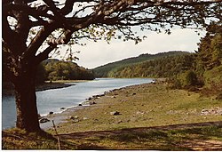
160:
Llyn Parc, with the water at a lower level than normal
1214:
1173:
1102:
1066:
1035:
999:
973:
942:
836:
745:
724:
677:
Introduction to the Lead mines of the Gwydyr Forest
446:and support from the Conservation Council (now the
220:There are also a number of smaller, unnamed lakes.
107:. In the 19th century, use was made of the quay at
247:, whose family had inherited the Wynn estate. The
1347:Forests and woodlands of Conwy County Borough
702:
315:The land owned by Natural Resources Wales in
8:
88:The forest broadly encircles the village of
1352:Tourist attractions in Conwy County Borough
651:, a leaflet published by Forest Enterprise.
709:
695:
687:
339:forest was used as a special stage in the
623:Joint Nature Conservation Committee site
377:mining was undertaken by the Romans—the
16:Forest in Snowdonia National Park, Wales
549:
363:The chimney of the former Llanrwst mine
130:, all of which are tributaries of the
216:Llyn Tynymynydd 1 acre (4,000 m)
207:Llyn Pencraig 5 acres (20,000 m)
7:
483:Site of Special Scientific Interest
388:The principal mines were those of:
213:Llyn Sarnau 3 acres (12,000 m)
210:Llyn Bychan 3 acres (12,000 m)
96:, and southwards to the village of
1357:Forests and woodlands of Snowdonia
355:The remains of Hafna mine and mill
14:
1261:
649:Gwydir Forest Park Miners Trail
1242:North Llanrwst railway station
1094:Waterloo Bridge (Betws-y-coed)
259:The majority of the forest is
1:
448:Countryside Council for Wales
420:
1222:Betws-y-Coed railway station
534:Grey Mare's Tail - waterfall
502:Special Area of Conservation
456:Gwynedd Archaeological Trust
1201:Conwy Valley Railway Museum
637:Tales from the Gwydyr Woods
504:(SAC). In February 2001, a
385:passed through the forest.
254:Tales from the Gwydyr Woods
1378:
1247:Tal-y-Cafn railway station
1232:Glan Conwy railway station
643:Mines of the Gwydyr Forest
463:Mines of the Gwydyr Forest
1255:
1227:Dolgarrog railway station
529:Caerdroia § Gwydir Forest
180:26 acres (110,000 m)
174:45 acres (180,000 m)
66:, which owned this area.
1237:Llanrwst railway station
510:Rhinolophus hipposideros
444:Welsh Development Agency
204:10 acres (40,000 m)
198:14 acres (57,000 m)
192:15 acres (61,000 m)
186:22 acres (89,000 m)
1145:Snowdonia National Park
1079:Conwy Suspension Bridge
558:"Origin of name Gwydir"
469:Rare plants and animals
317:Snowdonia National Park
70:Natural Resources Wales
56:Snowdonia National Park
682:Labyrinth in the Woods
478:
364:
356:
231:
161:
85:
40:
26:
1155:Trefriw Woollen Mills
1000:Hills & mountains
583:Review of Marin Trail
476:
362:
354:
226:
159:
83:
38:
24:
1084:Pont Fawr (Llanrwst)
1074:Conwy Railway Bridge
837:Rivers & streams
506:lesser horseshoe bat
52:Conwy county borough
1294: /
1036:Castles & forts
452:Welsh Mines Society
341:2013 Wales Rally GB
235:Forestry operations
1120:Conwy RSPB reserve
914:Ffrwd Cerriguniawn
599:2006-07-21 at the
594:Map of Marin Trail
479:
365:
357:
232:
230:from Gwydir Forest
162:
86:
41:
27:
1277:
1276:
1196:Conwy Valley line
1089:Tal-y-Cafn Bridge
783:Llanbedr-y-Cennin
746:Other settlements
495:forked spleenwort
328:(named after the
36:
1369:
1309:
1308:
1306:
1305:
1304:
1299:
1298:53.126°N 3.828°W
1295:
1292:
1291:
1290:
1287:
1268:Wales portal
1266:
1265:
1264:
1215:Railway stations
1165:Tŷ Mawr Wybrnant
1160:Tu Hwnt i'r Bont
1115:Cadair Ifan Goch
1027:Mynydd Hiraethog
1017:Bwlch-y-Ddeufaen
986:Grey Mare's Tail
894:Afon Porth-llwyd
879:Afon Gallt y Gwg
711:
704:
697:
688:
625:
620:
614:
609:
603:
591:
585:
580:
574:
573:
571:
569:
564:on 15 April 2008
560:. Archived from
554:
425:
422:
347:The former mines
287:species such as
202:Llyn Goddionduon
50:, is located in
37:
1377:
1376:
1372:
1371:
1370:
1368:
1367:
1366:
1312:
1311:
1302:
1300:
1296:
1293:
1288:
1285:
1283:
1281:
1280:
1278:
1273:
1262:
1260:
1251:
1210:
1169:
1098:
1062:
1031:
995:
969:
960:Llyn Geirionydd
938:
909:Afon Garreg-wen
859:Afon Hiraethlyn
854:Afon Geirionydd
832:
741:
720:
715:
658:
633:
628:
621:
617:
610:
606:
601:Wayback Machine
592:
588:
581:
577:
567:
565:
556:
555:
551:
547:
525:
471:
423:
349:
313:
249:First World War
237:
172:Llyn Geirionydd
146:massif itself.
78:
46:, also spelled
29:
17:
12:
11:
5:
1375:
1373:
1365:
1364:
1359:
1354:
1349:
1344:
1339:
1334:
1329:
1324:
1314:
1313:
1303:53.126; -3.828
1275:
1274:
1272:
1271:
1256:
1253:
1252:
1250:
1249:
1244:
1239:
1234:
1229:
1224:
1218:
1216:
1212:
1211:
1209:
1208:
1203:
1198:
1193:
1188:
1183:
1177:
1175:
1171:
1170:
1168:
1167:
1162:
1157:
1152:
1150:Surf Snowdonia
1147:
1142:
1137:
1132:
1127:
1122:
1117:
1112:
1110:Bodnant Garden
1106:
1104:
1103:Other features
1100:
1099:
1097:
1096:
1091:
1086:
1081:
1076:
1070:
1068:
1064:
1063:
1061:
1060:
1055:
1050:
1045:
1039:
1037:
1033:
1032:
1030:
1029:
1024:
1022:Cefn Cyfarwydd
1019:
1014:
1009:
1003:
1001:
997:
996:
994:
993:
988:
983:
977:
975:
971:
970:
968:
967:
962:
957:
952:
946:
944:
940:
939:
937:
936:
931:
926:
921:
919:Afon Melynllyn
916:
911:
906:
901:
896:
891:
886:
881:
876:
871:
866:
861:
856:
851:
846:
840:
838:
834:
833:
831:
830:
825:
820:
815:
810:
805:
800:
795:
790:
785:
780:
775:
770:
765:
760:
755:
749:
747:
743:
742:
740:
739:
734:
728:
726:
722:
721:
716:
714:
713:
706:
699:
691:
685:
684:
679:
674:
669:
664:
657:
656:External links
654:
653:
652:
646:
640:
632:
629:
627:
626:
615:
604:
586:
575:
548:
546:
543:
542:
541:
536:
531:
524:
521:
470:
467:
409:
408:
405:
402:
399:
396:
393:
348:
345:
312:
309:
273:Japanese larch
239:Following the
236:
233:
218:
217:
214:
211:
208:
205:
199:
196:Llyn Bodgynydd
193:
187:
181:
175:
169:
113:Thomas Pennant
77:
74:
15:
13:
10:
9:
6:
4:
3:
2:
1374:
1363:
1360:
1358:
1355:
1353:
1350:
1348:
1345:
1343:
1340:
1338:
1335:
1333:
1330:
1328:
1325:
1323:
1320:
1319:
1317:
1310:
1307:
1270:
1269:
1258:
1257:
1254:
1248:
1245:
1243:
1240:
1238:
1235:
1233:
1230:
1228:
1225:
1223:
1220:
1219:
1217:
1213:
1207:
1204:
1202:
1199:
1197:
1194:
1192:
1189:
1187:
1184:
1182:
1179:
1178:
1176:
1172:
1166:
1163:
1161:
1158:
1156:
1153:
1151:
1148:
1146:
1143:
1141:
1140:Moel Maelogan
1138:
1136:
1133:
1131:
1130:Klondyke mill
1128:
1126:
1125:Gwydir Forest
1123:
1121:
1118:
1116:
1113:
1111:
1108:
1107:
1105:
1101:
1095:
1092:
1090:
1087:
1085:
1082:
1080:
1077:
1075:
1072:
1071:
1069:
1065:
1059:
1056:
1054:
1053:Gwydir Castle
1051:
1049:
1046:
1044:
1041:
1040:
1038:
1034:
1028:
1025:
1023:
1020:
1018:
1015:
1013:
1010:
1008:
1007:Mynydd y Dref
1005:
1004:
1002:
998:
992:
989:
987:
984:
982:
979:
978:
976:
972:
966:
963:
961:
958:
956:
953:
951:
950:Llyn Crafnant
948:
947:
945:
941:
935:
932:
930:
927:
925:
922:
920:
917:
915:
912:
910:
907:
905:
902:
900:
897:
895:
892:
890:
887:
885:
882:
880:
877:
875:
872:
870:
867:
865:
862:
860:
857:
855:
852:
850:
849:Afon Crafnant
847:
845:
842:
841:
839:
835:
829:
826:
824:
821:
819:
816:
814:
811:
809:
806:
804:
801:
799:
796:
794:
791:
789:
786:
784:
781:
779:
776:
774:
771:
769:
766:
764:
761:
759:
756:
754:
751:
750:
748:
744:
738:
735:
733:
730:
729:
727:
723:
719:
712:
707:
705:
700:
698:
693:
692:
689:
683:
680:
678:
675:
673:
672:Gwydir Castle
670:
668:
665:
663:
660:
659:
655:
650:
647:
644:
641:
638:
635:
634:
630:
624:
619:
616:
613:
608:
605:
602:
598:
595:
590:
587:
584:
579:
576:
563:
559:
553:
550:
544:
540:
539:Klondyke mill
537:
535:
532:
530:
527:
526:
522:
520:
518:
513:
511:
507:
503:
498:
496:
492:
488:
487:metallophytes
484:
475:
468:
466:
464:
459:
457:
453:
449:
445:
439:
435:
433:
427:
417:
412:
407:Aberllyn Mine
406:
403:
400:
398:Llanrwst Mine
397:
394:
391:
390:
389:
386:
384:
380:
375:
371:
361:
353:
346:
344:
342:
336:
334:
331:
330:mountain bike
327:
321:
318:
310:
308:
306:
305:Sir John Wynn
300:
298:
294:
290:
286:
282:
278:
277:Norway spruce
274:
270:
266:
262:
257:
255:
250:
246:
245:Lord Ancaster
242:
234:
229:
225:
221:
215:
212:
209:
206:
203:
200:
197:
194:
191:
190:Llyn Glangors
188:
185:
182:
179:
176:
173:
170:
167:
166:Llyn Crafnant
164:
163:
158:
154:
151:
147:
145:
141:
137:
133:
129:
125:
121:
116:
114:
110:
106:
101:
99:
95:
91:
82:
75:
73:
71:
67:
65:
64:Gwydir Castle
61:
57:
53:
49:
45:
44:Gwydir Forest
23:
19:
1322:Betws-y-Coed
1279:
1259:
1135:Maenan Abbey
1124:
1048:Conwy Castle
929:Afon Tafolog
904:Afon Ddu (2)
889:Afon Ddu (1)
884:Nant y Goron
798:Llanrhychwyn
793:Llangelynnin
753:Betws-y-Coed
718:Conwy Valley
648:
642:
636:
618:
607:
589:
578:
566:. Retrieved
562:the original
552:
517:pine martens
514:
509:
499:
480:
462:
460:
440:
436:
428:
416:World War II
413:
410:
404:Pandora Mine
387:
366:
337:
333:manufacturer
322:
314:
301:
265:Sitka spruce
258:
253:
241:Forestry Act
238:
219:
152:
148:
117:
102:
90:Betws-y-Coed
87:
68:
47:
43:
42:
18:
1337:Dolwyddelan
1332:Capel Curig
1301: /
991:Fairy Falls
981:Conwy Falls
934:Afon Gyffin
874:Afon Llugwy
864:Afon Machno
828:Tyn-y-groes
424: 1960
401:Cyffty Mine
326:Marin Trail
269:Douglas fir
228:Moel Siabod
132:River Conwy
105:River Conwy
1327:Bro Machno
1316:Categories
1286:53°07′34″N
1206:Sarn Helen
1058:Pen y Gaer
974:Waterfalls
899:Afon Dulyn
869:Afon Lledr
844:Afon Conwy
818:Tal-y-Cafn
813:Tal-y-bont
788:Llanddoged
773:Glan Conwy
768:Eglwysbach
631:References
568:7 February
491:pennycress
432:B5106 road
395:Hafna Mine
383:Sarn Helen
379:Roman road
281:Scots pine
62:family of
1289:3°49′41″W
1174:Transport
1012:Tal y Fan
965:Llyn Parc
955:Llyn Elsi
763:Dolgarrog
438:on site.
392:Parc Mine
307:in 1604.
289:Welsh Oak
285:broadleaf
184:Llyn Parc
178:Llyn Elsi
140:Carneddau
98:Penmachno
76:Geography
60:John Wynn
1362:Rally GB
1043:Canovium
924:Afon Roe
732:Llanrwst
597:Archived
523:See also
142:and the
136:Glyderau
54:and the
1342:Trefriw
1067:Bridges
823:Trefriw
758:Caerhun
311:Tourism
261:conifer
144:Snowdon
109:Trefriw
94:Trefriw
803:Maenan
778:Henryd
454:, and
450:, the
138:, the
128:Machno
126:, and
120:Llugwy
48:Gwydyr
1191:B5106
943:Lakes
808:Rowen
737:Conwy
725:Towns
545:Notes
293:beech
124:Lledr
1181:A470
570:2006
493:and
374:zinc
372:and
370:lead
295:and
279:and
381:of
297:ash
1318::
1186:A5
497:.
465:.
426:.
421:c.
343:.
291:,
275:,
271:,
267:,
122:,
710:e
703:t
696:v
572:.
508:(
263:(
Text is available under the Creative Commons Attribution-ShareAlike License. Additional terms may apply.