410:
422:
176:
143:
136:
169:
29:
398:
336:
is significant as the summit rises over 2,700 feet (820 meters) above the river in approximately 1.5 mile. The nearest higher neighbor is
Cruiser Mountain, 3.5 miles (5.6 km) to the south-southeast.
409:
353:
zone characterized by long, usually very cold winters, and short, cool to mild summers. Winter temperatures can drop below −10 °F with wind chill factors below −30 °F.
91:
656:
504:
168:
666:
135:
495:
641:
671:
346:
500:
241:
436:
373:
periods. Formed in shallow seas, this sedimentary rock was initially uplifted beginning 170 million years ago when the
661:
381:
rocks 3 mi (4.8 km) thick, 50 miles (80 km) wide and 160 miles (260 km) long over younger rock of the
397:
84:
421:
329:
321:
289:
205:
490:
317:
64:
54:
610:
313:
74:
561:
256:
587:
333:
268:
579:
350:
569:
374:
362:
273:
623:
236:
223:
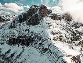
324:. The 7,700-foot north peak and 7,698-foot south peak are 0.35 mile apart. Precipitation
308:
Gable Peaks is located at the north end of the
Trilobite Range, which is a subset of the
565:
28:
325:
309:
227:
216:
650:
285:
209:
591:
378:
366:
261:
574:
549:
382:
293:
583:
106:
93:
370:
297:
524:
463:
415:
Aerial view of north peak to left, with south peak to right in cloud.
44:
605:
Gadd, Ben (2008). "Geology of the Rocky
Mountains and Columbias".
550:"Updated world map of the Köppen−Geiger climate classification"
548:
Peel, M. C.; Finlayson, B. L.; McMahon, T. A. (2007).
267:
255:
250:
235:
215:
201:
122:
83:
73:
63:
53:
43:
38:
21:
312:. It is situated on the common boundary shared by
458:
456:
454:
452:
8:
18:
573:
16:Mountain in the American state of Montana
505:United States Department of the Interior
403:North peak to left, south peak to right.
448:
393:
619:
608:
485:
483:
328:from the mountain drains north to the
657:Mountains of Flathead County, Montana
284:is a remote 7,700-foot (2,347-metre)
7:
496:Geographic Names Information System
175:
142:
14:
377:fault pushed an enormous slab of
525:"Gable Peaks, South - 7,698' MT"
464:"Gable Peaks, North - 7,700' MT"
420:
408:
396:
174:
167:
141:
134:
27:
501:United States Geological Survey
437:Geology of the Rocky Mountains
349:, Gable Peaks is located in a
1:
667:North American 2000 m summits
347:Köppen climate classification
191:Show map of the United States
188:Location in the United States
107:48.03996374°N 113.17548756°W
49:7,700 ft (2,347 m)
361:Gable Peaks is composed of
79:3.34 mi (5.38 km)
688:
330:Middle Fork Flathead River
112:48.03996374; -113.17548756
575:10.5194/hess-11-1633-2007
127:
69:Trilobite Peak (8,245 ft)
33:Aerial view of north peak
26:
672:Flathead National Forest
322:Flathead National Forest
206:Flathead County, Montana
59:480 ft (146 m)
554:Hydrol. Earth Syst. Sci
318:Bob Marshall Wilderness
618:Cite journal requires
365:laid down during the
320:, on land managed by
314:Great Bear Wilderness
662:Mountains of Montana
288:mountain located in
566:2007HESS...11.1633P
158:Show map of Montana
155:Location in Montana
103: /
334:topographic relief
39:Highest point
351:subarctic climate
279:
278:
679:
628:
627:
621:
616:
614:
606:
602:
596:
595:
577:
560:(5): 1633–1644.
545:
539:
538:
536:
535:
521:
515:
514:
512:
511:
487:
478:
477:
475:
474:
460:
424:
412:
400:
375:Lewis Overthrust
363:sedimentary rock
274:Sedimentary rock
219:
192:
178:
177:
171:
159:
145:
144:
138:
118:
117:
115:
114:
113:
108:
104:
101:
100:
99:
96:
31:
19:
687:
686:
682:
681:
680:
678:
677:
676:
647:
646:
637:
632:
631:
617:
607:
604:
603:
599:
547:
546:
542:
533:
531:
529:listsofjohn.com
523:
522:
518:
509:
507:
489:
488:
481:
472:
470:
468:listsofjohn.com
462:
461:
450:
445:
433:
428:
425:
416:
413:
404:
401:
391:
359:
343:
306:
290:Flathead County
231:Trilobite Range
230:
226:
224:Rocky Mountains
217:
197:
196:
195:
194:
193:
190:
189:
186:
185:
184:
183:
179:
162:
161:
160:
157:
156:
153:
152:
151:
150:
146:
111:
109:
105:
102:
97:
94:
92:
90:
89:
34:
17:
12:
11:
5:
685:
683:
675:
674:
669:
664:
659:
649:
648:
645:
644:
636:
635:External links
633:
630:
629:
620:|journal=
597:
540:
516:
479:
447:
446:
444:
441:
440:
439:
432:
429:
427:
426:
419:
417:
414:
407:
405:
402:
395:
392:
390:
387:
358:
355:
342:
339:
310:Flathead Range
305:
302:
277:
276:
271:
265:
264:
259:
253:
252:
248:
247:
239:
233:
232:
228:Flathead Range
221:
213:
212:
203:
199:
198:
187:
181:
180:
173:
172:
166:
165:
164:
163:
154:
148:
147:
140:
139:
133:
132:
131:
130:
129:
128:
125:
124:
120:
119:
87:
81:
80:
77:
71:
70:
67:
61:
60:
57:
51:
50:
47:
41:
40:
36:
35:
32:
24:
23:
15:
13:
10:
9:
6:
4:
3:
2:
684:
673:
670:
668:
665:
663:
660:
658:
655:
654:
652:
643:
639:
638:
634:
625:
612:
601:
598:
593:
589:
585:
581:
576:
571:
567:
563:
559:
555:
551:
544:
541:
530:
526:
520:
517:
506:
502:
498:
497:
492:
491:"Gable Peaks"
486:
484:
480:
469:
465:
459:
457:
455:
453:
449:
442:
438:
435:
434:
430:
423:
418:
411:
406:
399:
394:
388:
386:
384:
380:
376:
372:
368:
364:
356:
354:
352:
348:
345:Based on the
340:
338:
335:
331:
327:
323:
319:
315:
311:
303:
301:
299:
295:
291:
287:
286:double summit
283:
275:
272:
270:
266:
263:
260:
258:
254:
249:
246:
243:
240:
238:
234:
229:
225:
222:
220:
214:
211:
207:
204:
200:
170:
137:
126:
121:
116:
88:
86:
82:
78:
76:
72:
68:
66:
62:
58:
56:
52:
48:
46:
42:
37:
30:
25:
20:
611:cite journal
600:
557:
553:
543:
532:. Retrieved
528:
519:
508:. Retrieved
494:
471:. Retrieved
467:
360:
344:
307:
281:
280:
269:Type of rock
244:
218:Parent range
642:Gable Peaks
379:precambrian
367:Precambrian
304:Description
282:Gable Peaks
262:Precambrian
257:Age of rock
245:Gable Peaks
182:Gable Peaks
149:Gable Peaks
110: /
98:113°10′32″W
85:Coordinates
65:Parent peak
22:Gable Peaks
651:Categories
534:2021-10-29
510:2021-10-29
473:2021-10-29
443:References
383:cretaceous
294:U.S. state
95:48°02′24″N
55:Prominence
640:Weather:
584:1027-5606
123:Geography
75:Isolation
45:Elevation
431:See also
385:period.
371:Jurassic
316:and the
237:Topo map
202:Location
592:9654551
562:Bibcode
389:Gallery
357:Geology
341:Climate
298:Montana
292:of the
251:Geology
590:
582:
332:, and
326:runoff
588:S2CID
624:help
580:ISSN
242:USGS
210:U.S.
570:doi
369:to
296:of
653::
615::
613:}}
609:{{
586:.
578:.
568:.
558:11
556:.
552:.
527:.
503:,
499:.
493:.
482:^
466:.
451:^
300:.
208:,
626:)
622:(
594:.
572::
564::
537:.
513:.
476:.
Text is available under the Creative Commons Attribution-ShareAlike License. Additional terms may apply.