369:
357:
31:
393:
333:
381:
345:
47:
266:
314:, was pursuing a number of agricultural improvements on his extensive estates and other landowners followed his example. Intensive drainage work may also have taken place in the 1740s as part of the improvements undertaken to provide employment for Irish estate workers during the Irish potato famines of the 1740s and the mid 19th centuries. Many drainage schemes also date to the end of World War I when many soldiers returned en masse to civilian life.
412:
54:
322:
The Lands and mansion house of
Galrigs were renamed 'Newfield' circa 1723 by Captain Lawrence Nugent who had fought at the Battle of Neufeldt (Newfield) in Germany, however Galrigside Farm retained its ancient name. No link between the draining of the Galrig Loch and the 'New Field' therefore seems
301:
near
Shewalton. The farm on the loch's edge is recorded as Mosside. This is the last map to show the loch and this indicates that its drainage took place in the early 18th century. Roy's map of 1747 shows no clear loch, however a habitation recorded as 'Lochend' is present. The OS maps record the
273:
No watermills seem to have been associated with
Galrigs Loch and the Ordnance Survey maps of the mid 19th century only show the farm of Lochend or Lochside sitting above the old loch's site, approached by a lane, hedged on both sides, leading down from Newfield Mains. It may have been used for
244:
once of a substantial extent, fed mainly by the
Broomhill Burn, rainfall, and field drainage. It is recorded in the placenames of Lochend, Lochside, and Mosside. The Broomhill Burn has been diverted away from the site which however remains dominated by rushes
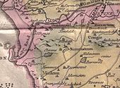
256:
The lands, variously known as 'Gariggis', 'Galriggis' and even 'Garrix', were held by a
William Wallace in 1578, later by the Craufurds, and in the 1860s by the well known Finnie family from Kilmarnock who were heavily involved in the coal industry.
568:
General View of The
Agriculture of the County of Ayr; observations on the means of its improvement; drawn up for the consideration of the Board of Agriculture, and Internal Improvements, with Beautiful
278:, however Newfield House had its own curling pond, opened on 4 February 1856, the site of Eglinton Jug playdowns. The 'Finnie Kettle' annual curling competition also took place at Newfield with a "
297:'s survey of circa 1604, shows the loch as a significant body of water, extending towards Gar Rigs (sic), with no inflow and one outflow running down to the Dundonald Burn and eventually into the
249:
species) and constitutes poor quality grazing. The loch site still floods in winter. No open outflow is now present and the site shows evidence of drainage in the form of
97:
311:
368:
332:
344:
380:
392:
356:
659:
46:
649:
620:
605:
590:
209:
664:
644:
285:
At the foot of the brae below where the now demolished
Newfield House was situated, are remains of a stone dam and sluice.
323:
to exist. Lochside Farm is now only marked by its foundations although OS maps show it as still standing into the 1980s.
30:
225:
78:
654:
487:
154:
142:
265:
616:
601:
586:
241:
425:
417:
250:
229:
166:
82:
638:
129:
298:
294:
523:
224:
was a substantial freshwater loch situated in low lying area between
Newfield and
407:
282:" as the challenge cup. This competition still takes place at an indoor rink.
499:
112:
99:
275:
143:
155:
310:
Although the loch's drainage may have begun in the 18th century when
264:
135:
269:
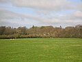
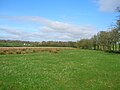
The site of
Galrigs Loch lay in between Dundonald and Newfield.
35:
The site of the loch looking towards
Dundonald and the castle
598:
Lost Ayrshire : Ayrshire's Lost Architectural Heritage
466:
511:
232:, Scotland. It was drained in the early 18th century.
208:
204:
196:
188:
180:
176:
165:
153:
141:
128:
89:
74:
23:
90:
240:The loch was a natural feature, a post-glacial
18:Old freshwater loch in South Ayrshire, Scotland
576:Dundonald. A Contribution to Parochial History
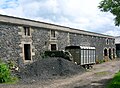
350:The south range of nearby Newfield Mains Farm.
630:. AA&NHS. Ayrshire Notes 42, Autumn 2011.
8:
386:A view of Newfield Mains from the loch site.
312:Alexander Montgomerie, 10th Earl of Eglinton
280:..tea kettle modelled as a curling stone..
20:
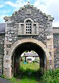
338:Pend and dovecot at Newfield Mains Farm.
66:Location of Galrigs Loch, North Ayrshire
441:
374:The old lane leading to Newfield Mains.
325:
398:The eastern shoreline of the old loch.
583:Ayrshire : Discovering a County.
7:
53:
14:
293:Blaeu's map of 1654, dating from
600:. Edinburgh : Birlinn Ltd.
410:
391:
379:
367:
355:
343:
331:
52:
45:
29:
195:
187:
179:
615:. Glasgow : Neil Wilson.
327:Views of the Galrigs Loch site
1:
578:. Glasgow : John Wyllie.
73:
660:Freshwater lochs of Scotland
585:Ayr : Fort Publishing.
535:MacIntosh, Pages 37 & 39
526:Retrieved : 2011-04-09
514:Retrieved : 2011-04-09
502:Retrieved : 2011-04-09
490:Retrieved : 2020-11-29
478:McClure, pages 16 & 18.
469:Retrieved : 2020-11-29
302:farm's name as 'Lochside'.
681:
611:MacIntosh, Donald (2006).
362:The site of Lochside Farm.
650:History of South Ayrshire
40:
28:
665:Lakes of South Ayrshire
645:Lochs of South Ayrshire
566:Aiton, William (1811).
457:Paterson, Pages 486-490
488:Scottish Curling Sites
270:
192:600 yards (550 m)
184:800 yards (730 m)
113:55.576111°N 4.581611°W
553:Love (2003), Page 230
289:Cartographic evidence
268:
574:Gillespie, James H.
544:Love (2005), Page 53
118:55.576111; -4.581611
613:Travels in Galloway
596:Love, Dane (2005).
581:Love, Dane (2003).
448:Gillespie, Page 114
109: /
626:McClure, David C.
271:
628:The Finnie Kettle
218:
217:
672:
554:
551:
545:
542:
536:
533:
527:
521:
515:
509:
503:
497:
491:
485:
479:
476:
470:
464:
458:
455:
449:
446:
420:
415:
414:
413:
395:
383:
371:
359:
347:
335:
157:
156:Primary outflows
145:
124:
123:
121:
120:
119:
114:
110:
107:
106:
105:
102:
92:
56:
55:
49:
33:
21:
680:
679:
675:
674:
673:
671:
670:
669:
635:
634:
633:
562:
557:
552:
548:
543:
539:
534:
530:
522:
518:
510:
506:
498:
494:
486:
482:
477:
473:
465:
461:
456:
452:
447:
443:
439:
434:
426:Caprington Loch
418:Scotland portal
416:
411:
409:
406:
399:
396:
387:
384:
375:
372:
363:
360:
351:
348:
339:
336:
320:
308:
291:
263:
238:
169: countries
144:Primary inflows
134:Old freshwater
117:
115:
111:
108:
103:
100:
98:
96:
95:
70:
69:
68:
67:
64:
63:
62:
61:
57:
36:
19:
12:
11:
5:
678:
676:
668:
667:
662:
657:
652:
647:
637:
636:
632:
631:
624:
609:
594:
579:
572:
563:
561:
558:
556:
555:
546:
537:
528:
516:
504:
492:
480:
471:
467:25 inch OS Map
459:
450:
440:
438:
435:
433:
430:
429:
428:
422:
421:
405:
402:
401:
400:
397:
390:
388:
385:
378:
376:
373:
366:
364:
361:
354:
352:
349:
342:
340:
337:
330:
328:
319:
316:
307:
304:
290:
287:
262:
259:
251:rig and furrow
237:
234:
230:South Ayrshire
216:
215:
212:
206:
205:
202:
201:
198:
194:
193:
190:
186:
185:
182:
178:
177:
174:
173:
170:
163:
162:
161:Dundonald Burn
159:
151:
150:
149:Broomhill Burn
147:
139:
138:
132:
126:
125:
93:
87:
86:
83:South Ayrshire
76:
72:
71:
65:
59:
58:
51:
50:
44:
43:
42:
41:
38:
37:
34:
26:
25:
17:
13:
10:
9:
6:
4:
3:
2:
677:
666:
663:
661:
658:
656:
653:
651:
648:
646:
643:
642:
640:
629:
625:
622:
621:1-897784-92-9
618:
614:
610:
607:
606:1-84158-356-1
603:
599:
595:
592:
591:0-9544461-1-9
588:
584:
580:
577:
573:
570:
565:
564:
559:
550:
547:
541:
538:
532:
529:
525:
520:
517:
513:
508:
505:
501:
496:
493:
489:
484:
481:
475:
472:
468:
463:
460:
454:
451:
445:
442:
436:
431:
427:
424:
423:
419:
408:
403:
394:
389:
382:
377:
370:
365:
358:
353:
346:
341:
334:
329:
326:
324:
318:Micro-history
317:
315:
313:
305:
303:
300:
296:
288:
286:
283:
281:
277:
267:
260:
258:
254:
252:
248:
243:
242:'Kettle Hole'
235:
233:
231:
227:
223:
213:
211:
207:
203:
199:
197:Average depth
191:
183:
175:
171:
168:
164:
160:
158:
152:
148:
146:
140:
137:
133:
131:
127:
122:
94:
88:
84:
80:
77:
48:
39:
32:
27:
22:
16:
655:Former lochs
627:
612:
597:
582:
575:
567:
549:
540:
531:
519:
507:
495:
483:
474:
462:
453:
444:
321:
309:
299:River Irvine
295:Timothy Pont
292:
284:
279:
272:
255:
246:
239:
222:Galrigs Loch
221:
219:
101:55°34′34.0″N
60:Galrigs Loch
24:Galrigs Loch
15:
500:Blaeu's Map
181:Max. length
116: /
104:4°34′53.8″W
91:Coordinates
639:Categories
571:. Glasgow.
569:Engravings
432:References
189:Max. width
85:, Scotland
512:Roy's Map
226:Dundonald
79:Dundonald
404:See also
306:Drainage
172:Scotland
75:Location
560:Sources
276:curling
236:History
210:Islands
200:Shallow
619:
604:
589:
524:OS Map
247:Juncus
437:Notes
261:Usage
167:Basin
617:ISBN
602:ISBN
587:ISBN
220:The
214:None
136:loch
130:Type
228:in
641::
253:.
81:,
623:.
608:.
593:.
245:(
Text is available under the Creative Commons Attribution-ShareAlike License. Additional terms may apply.