60:
44:
67:
412:
389:. The combined river flows in the same valley and in the same direction as Gar Tsangpo. Thus by physical geography, Gar Tsangpo is the "Indus River". The Tibetans however regard Sênggê Zangbo as the main Indus River, and treat Gar Tsangpo as a tributary.
454:, flows in the same direction as Gartang. For this reason, western explorers have traditionally regarded Gartang as the main source of the Indus River. However, the Tibetans regard Sengge Zangbo as the main Indus River and the Gartang as its tributary.
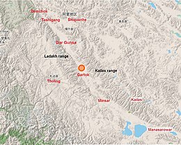
473:, lie along the course of the Gartang, separated by 40 miles (64 km). The two locations together have been called "Gartok" and served as the administrative headquarters of
481:
administration of Tibet. The Lhasa-appointed administrator, called Garpön, used to stay at Gar Yarsa during the summemr months, and at Gar Gunsa during the winter. After the
59:
567:
250:
396:
374:
482:
447:
382:
174:
94:
562:
370:
121:
43:
395:, the former administrative headquarters of Ngari is in the Gar Valley. The present headquarters, under
328:
378:
543:
474:
446:
and flows in a wide arc towards the Gar Valley. The point of confluence is near the town of
366:
336:
131:
478:
320:
556:
439:
235:
521:
519:
506:
504:
502:
443:
432:
424:
160:
435:. The slope of the valley is extremely gentle, only about 2 metres per kilometre.
403:
in the Sênggê Zangbo valley, close to the point of confluence of the two rivers.
451:
386:
362:
308:
220:
265:
252:
189:
176:
486:
470:
466:
416:
400:
17:
450:(Zhaxigang). After the confluence, the combined river, regarded as the
411:
392:
344:
525:
510:
438:
After a distance of 130 kilometres (81 mi), the
Gartang joins
410:
111:
485:
in 1950, the headquarters of Ngari was moved to a new town of
427:(Gangdise Shan). From there, the river flows northwest in the
423:
The sources of
Gartang are on the southwestern slopes of the
442:(Shiquan He), which originates on the northern slopes of
431:, the tectonic valley between the Kailas Range and the
86:
304:
299:
291:
281:
242:
229:
219:
205:
166:
154:
146:
137:
127:
117:
107:
102:
82:
32:
457:The Gartang river drains an area of 6,060 km2.
8:
526:I︠U︡sov, Physical Geography of Tibet (1959)
511:I︠U︡sov, Physical Geography of Tibet (1959)
74:Confluence of Gar Tsangpo and Sênggê Zangbo
548:, U.S. Joint Publications Research Service
465:Two well-known villages cum encampments,
48:Gar Tsangpo near the Ngari Gunsa Airport
498:
27:River in Tibet Autonomous Region, China
29:
7:
66:
377:. It merges with other headwater,
25:
65:
58:
42:
568:Tributaries of the Indus River
349:
244: • coordinates
168: • coordinates
1:
287:4,300 metres (14,100 ft)
211:5,000 metres (16,000 ft)
138:Physical characteristics
489:on the Sengge Zangbo river.
283: • elevation
207: • elevation
545:Physical Geography of Tibet
483:Chinese annexation of Tibet
231: • location
156: • location
584:
340:
324:
215:
142:
87:
53:
41:
477:(West Tibet) during the
361:, is a headwater of the
295:130 km (81 mi)
542:I︠U︡sov, B. V. (1959),
122:Tibet Autonomous Region
420:
399:administration, is at
381:, near the village of
414:
300:Basin features
266:32.4409°N 79.7121°E
262: /
190:31.3836°N 80.7254°E
186: /
421:
419:marked as Gartok.
314:
313:
16:(Redirected from
575:
549:
529:
523:
514:
508:
415:Gar Valley with
367:Ngari Prefecture
351:
342:
326:
277:
276:
274:
273:
272:
271:32.4409; 79.7121
267:
263:
260:
259:
258:
255:
208:
201:
200:
198:
197:
196:
195:31.3836; 80.7254
191:
187:
184:
183:
182:
179:
169:
157:
132:Ngari Prefecture
98:
95:Standard Tibetan
90:
89:
69:
68:
62:
46:
30:
21:
583:
582:
578:
577:
576:
574:
573:
572:
563:Rivers of Tibet
553:
552:
541:
538:
533:
532:
524:
517:
509:
500:
495:
479:Ganden Phodrang
463:
409:
353:), also called
284:
270:
268:
264:
261:
256:
253:
251:
249:
248:
245:
232:
206:
194:
192:
188:
185:
180:
177:
175:
173:
172:
167:
155:
92:
78:
77:
76:
75:
72:
71:
70:
49:
37:
34:
28:
23:
22:
15:
12:
11:
5:
581:
579:
571:
570:
565:
555:
554:
551:
550:
537:
534:
531:
530:
515:
497:
496:
494:
491:
462:
459:
408:
405:
333:sgar gtsang po
312:
311:
306:
302:
301:
297:
296:
293:
289:
288:
285:
282:
279:
278:
246:
243:
240:
239:
233:
230:
227:
226:
223:
217:
216:
213:
212:
209:
203:
202:
170:
164:
163:
158:
152:
151:
148:
144:
143:
140:
139:
135:
134:
129:
125:
124:
119:
115:
114:
109:
105:
104:
100:
99:
84:
80:
79:
73:
64:
63:
57:
56:
55:
54:
51:
50:
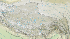
47:
39:
38:
35:
26:
24:
14:
13:
10:
9:
6:
4:
3:
2:
580:
569:
566:
564:
561:
560:
558:
547:
546:
540:
539:
535:
528:, p. 11.
527:
522:
520:
516:
513:, p. 10.
512:
507:
505:
503:
499:
492:
490:
488:
484:
480:
476:
472:
468:
460:
458:
455:
453:
449:
445:
441:
440:Sengge Zangbo
436:
434:
430:
426:
418:
413:
406:
404:
402:
398:
394:
390:
388:
384:
380:
379:Sênggê Zangbo
376:
372:
368:
364:
360:
356:
352:
346:
338:
334:
330:
322:
318:
310:
307:
303:
298:
294:
290:
286:
280:
275:
247:
241:
237:
236:Sengge Zangbo
234:
228:
224:
222:
218:
214:
210:
204:
199:
171:
165:
162:
159:
153:
149:
145:
141:
136:
133:
130:
126:
123:
120:
116:
113:
110:
106:
101:
96:
85:
81:
61:
52:
45:
40:
31:
19:
544:
536:Bibliography
464:
456:
444:Mount Kailas
437:
433:Ladakh Range
428:
425:Kailas Range
422:
391:
385:to form the
358:
354:
348:
332:
316:
315:
238:, Gar Valley
161:Kailas Range
452:Indus River
387:Indus River
363:Indus River
350:Găěr Zàngbù
317:Gar Tsangpo
309:Indus River
305:Progression
269: /
193: /
83:Native name
33:Gar Tsangpo
557:Categories
493:References
429:Gar Valley
325:སྒར་གཙང་པོ
257:79°42′44″E
254:32°26′27″N
181:80°43′31″E
178:31°23′01″N
88:སྒར་གཙང་པོ
18:Gar Valley
487:Shiquanhe
471:Gar Gunsa
467:Gar Yarsa
448:Tashigang
417:Gar Yarsa
401:Shiquanhe
383:Tashigang
359:Gar River
103:Location
461:History
365:in the
355:Gartang
337:Chinese
321:Tibetan
108:Country
36:Gartang
407:Course
393:Gartok
347::
345:pinyin
339::
292:Length
225:
150:
147:Source
128:Region
91:
475:Ngari
375:China
371:Tibet
329:Wylie
221:Mouth
118:State
112:China
469:and
341:噶尔藏布
397:PRC
357:or
559::
518:^
501:^
373:,
369:,
343:;
335:;
331::
327:,
323::
319:(
97:)
93:(
20:)
Text is available under the Creative Commons Attribution-ShareAlike License. Additional terms may apply.