231:
42:
220:
110:
49:
335:
Smith, D., Gaffney, V., Grossman, D., Howard, A.J., Milosevic, A., Ostir, K., Podobnikar, T., Smith, W., Tetlow, E., Tingle, M., and
Tinsley, H. 2006. Assessing the later prehistoric environmental archaeology and landscape development of the Cetina Valley, Croatia.
359:
70:
230:
322:
41:
210:
311:
266:
Tilurium guarded the entrance to the Cetina valley from the south and the approach to the provincial capital at
102:
189:
127:
199:
122:
134:
293:
287:
289:
Register of spatial units of the State
Geodetic Administration of the Republic of Croatia
353:
219:
17:
85:
72:
297:
253:
180:
260:
256:
223:
242:
115:
267:
206:
185:
246:
229:
218:
139:
245:
at the top of the hill of Gardun, just 1 km south of
319:
Census of
Population, Households and Dwellings in 2021
196:
179:
171:
163:
158:
150:
145:
133:
121:
101:
28:
263:started on the southern outskirts of the village.
8:
312:"Population by Age and Sex, by Settlements"
252:In the 1997, excavations of the remains of
25:
360:Populated places in Split-Dalmatia County
279:
178:
157:
144:
100:
65:
34:
195:
170:
162:
149:
132:
120:
7:
14:
154:4.8 km (1.9 sq mi)
108:
47:
40:
23:Place in Split-Dalmatia, Croatia
48:
1:
323:Croatian Bureau of Statistics
16:For the village in Iran, see
376:
15:
338:Environmental Archaeology
66:
35:
235:
227:
233:
222:
198: • Summer (
175:14/km (37/sq mi)
172: • Density
86:43.6117°N 16.7181°E
82: /
236:
228:
164: • Total
151: • Total
217:
216:
367:
344:
333:
327:
326:
316:
308:
302:
301:
284:
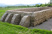
234:Cemetery, detail
203:
114:
112:
111:
97:
96:
94:
93:
92:
91:43.6117; 16.7181
87:
83:
80:
79:
78:
75:
51:
50:
44:
26:
375:
374:
370:
369:
368:
366:
365:
364:
350:
349:
348:
347:
334:
330:
314:
310:
309:
305:
286:
285:
281:
276:
197:
109:
107:
90:
88:
84:
81:
76:
73:
71:
69:
68:
62:
61:
60:
59:
58:
57:
56:
52:
31:
24:
21:
12:
11:
5:
373:
371:
363:
362:
352:
351:
346:
345:
328:
303:
278:
277:
275:
272:
215:
214:
204:
194:
193:
183:
177:
176:
173:
169:
168:
165:
161:
160:
156:
155:
152:
148:
147:
143:
142:
137:
131:
130:
128:Split-Dalmatia
125:
119:
118:
105:
99:
98:
64:
63:
54:
53:
46:
45:
39:
38:
37:
36:
33:
32:
29:
22:
13:
10:
9:
6:
4:
3:
2:
372:
361:
358:
357:
355:
342:
339:
332:
329:
324:
320:
313:
307:
304:
299:
295:
291:
290:
283:
280:
273:
271:
269:
264:
262:
258:
255:
250:
248:
244:
240:
232:
225:
221:
212:
208:
205:
201:
191:
187:
184:
182:
174:
166:
153:
141:
138:
136:
129:
126:
124:
117:
106:
104:
95:
67:Coordinates:
43:
27:
19:
343:(2): 171-186
340:
337:
331:
318:
306:
288:
282:
265:
251:
238:
237:
18:Gardun, Iran
89: /
321:. Zagreb:
298:Q119585703
274:References
159:Population
77:16°43′05″E
74:43°36′42″N
254:legionary
181:Time zone
354:Category
294:Wikidata
261:Tilurium
257:fortress
224:Tilurium
325:. 2022.
243:village
226:remains
116:Croatia
103:Country
315:(xlsx)
296:
268:Salona
239:Gardun
123:County
113:
55:Gardun
30:Gardun
247:Trilj
241:is a
207:UTC+2
186:UTC+1
140:Trilj
211:CEST
146:Area
135:City
259:of
200:DST
190:CET
356::
341:11
317:.
292:.
270:.
249:.
167:68
300:.
213:)
209:(
202:)
192:)
188:(
20:.
Text is available under the Creative Commons Attribution-ShareAlike License. Additional terms may apply.