24:
198:, describes the geologic history of Garrett Island: "'Garrett Island is the geologic remnant of what was once an offshore volcano in an ancient sea. The rocky high ground on the island's west side is the remains of the volcanic core. Basalt and quartz formed by the volcanic activity are still present.'" Garrett Island is the only rocky island in the tidal waters of the
496:
65:
501:
511:
307:
298:
171:
506:
336:
303:
179:
427:
238:
traders from the Upper
Chesapeake region and built Fort Conquest on what was then called "Palmer's Island." During the later
167:
214:
may have visited the island in 1608 but there is no definitive documentation proving this. In 1622, the island was given to
250:
175:
28:
246:
163:
366:
23:
293:
215:
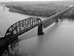
147:
49:
242:, the island was farmed by a family named "Watson" and it eventually came to be called "Watson Island."
211:
401:
159:
223:
239:
227:
155:
254:
199:
481:
253:
could be built across the
Susquehanna River at that point. The island was named after
490:
344:
120:
231:
454:
274:
270:
407:
219:
80:
67:
235:
210:
Human presence on
Garrett Island is known from 8,000 to 5,000 years ago.
151:
53:
234:
on the island. In the same year, Maryland troops evicted
Claiborne's
374:
226:, and the earliest documented European presence dates to 1637 when
266:
265:
Garrett Island provides habitat for 44 species of birds including
428:"A Tale of Two Islands: Geography Limits Garrett's Growth"
337:"Steps Being Taken to Allow Public to Set Foot on Island"
330:
328:
326:
324:
133:
128:
112:
104:
96:
59:
45:
40:
482:NOAA Nautical Chart 12274 (showing Garrett Island)
154:, 1.8 miles (2.9 km) from the mouth of the
421:
419:
417:
394:
392:
8:
16:
100:0.309375 sq mi (0.80128 km)
22:
15:
308:United States Department of the Interior
31:crossing Garrett Island (center at top).
285:
7:
497:Landforms of Cecil County, Maryland
299:Geographic Names Information System
245:Watson Island was purchased by the
172:Blackwater National Wildlife Refuge
257:, then president of the railroad.
14:
453:Payette, Pete (August 30, 2010).
502:Islands of the Susquehanna River
512:Uninhabited islands of Maryland
459:North American Forts, 1526–1956
455:"American Forts East: Maryland"
304:United States Geological Survey
180:Thomas J. Hatem Memorial Bridge
174:. The island is crossed by the
168:U.S. Fish and Wildlife Service
1:
373:. May 1, 2010. Archived from
426:Kennedy, Jim (May 5, 2010).
176:CSX Susquehanna River Bridge
29:CSX Susquehanna River Bridge
277:, and 14 species of ducks.
247:Baltimore and Ohio Railroad
528:
367:"Cecil's Sleeping Volcano"
249:(B&O) in the 1880s so
178:on the north side and the
507:River islands of Maryland
406:Vol. 148, Page
117:
81:39.5651122°N 76.0888391°W
36:
21:
335:Lutz, Lara (June 2009).
146:is an island located in
108:79 ft (24.1 m)
166:. It is managed by the
86:39.5651122; -76.0888391
341:Chesapeake Bay Journal
196:Chesapeake Bay Journal
105:Highest elevation
434:. exploreharford.com
402:Congressional Record
377:on October 30, 2010
182:on the south side.
158:, directly west of
77: /
18:
228:William Claiborne
156:Susquehanna River
141:
140:
519:
470:
469:
467:
465:
450:
444:
443:
441:
439:
423:
412:
411:
396:
387:
386:
384:
382:
363:
357:
356:
354:
352:
347:on March 8, 2012
343:. Archived from
332:
319:
318:
316:
314:
294:"Garrett Island"
290:
92:
91:
89:
88:
87:
82:
78:
75:
74:
73:
70:
26:
19:
527:
526:
522:
521:
520:
518:
517:
516:
487:
486:
478:
473:
463:
461:
452:
451:
447:
437:
435:
425:
424:
415:
410:(July 15, 2002)
398:
397:
390:
380:
378:
365:
364:
360:
350:
348:
334:
333:
322:
312:
310:
292:
291:
287:
283:
263:
255:John W. Garrett
240:colonial period
208:
188:
170:as part of the
124:
85:
83:
79:
76:
71:
68:
66:
64:
63:
32:
12:
11:
5:
525:
523:
515:
514:
509:
504:
499:
489:
488:
485:
484:
477:
476:External links
474:
472:
471:
445:
413:
388:
371:Cecil Observer
358:
320:
284:
282:
279:
262:
259:
230:established a
207:
204:
200:Chesapeake Bay
194:, quoting the
192:Cecil Observer
187:
184:
164:Havre de Grace
144:Garrett Island
139:
138:
135:
131:
130:
126:
125:
118:
115:
114:
113:Administration
110:
109:
106:
102:
101:
98:
94:
93:
61:
57:
56:
47:
43:
42:
38:
37:
34:
33:
27:
17:Garrett Island
13:
10:
9:
6:
4:
3:
2:
524:
513:
510:
508:
505:
503:
500:
498:
495:
494:
492:
483:
480:
479:
475:
460:
456:
449:
446:
433:
429:
422:
420:
418:
414:
409:
405:
403:
395:
393:
389:
376:
372:
368:
362:
359:
346:
342:
338:
331:
329:
327:
325:
321:
309:
305:
301:
300:
295:
289:
286:
280:
278:
276:
272:
268:
260:
258:
256:
252:
248:
243:
241:
237:
233:
229:
225:
221:
218:as part of a
217:
216:Edward Palmer
213:
205:
203:
201:
197:
193:
185:
183:
181:
177:
173:
169:
165:
162:and north of
161:
157:
153:
149:
145:
136:
132:
127:
123:
122:
121:United States
116:
111:
107:
103:
99:
95:
90:
62:
58:
55:
51:
48:
44:
39:
35:
30:
25:
20:
464:November 29,
462:. Retrieved
458:
448:
438:November 28,
436:. Retrieved
431:
400:
381:November 17,
379:. Retrieved
375:the original
370:
361:
351:November 16,
349:. Retrieved
345:the original
340:
313:November 16,
311:. Retrieved
297:
288:
275:tundra swans
271:common loons
264:
244:
232:trading post
224:King James I
209:
195:
191:
189:
148:Cecil County
143:
142:
129:Demographics
119:
50:Cecil County
84: /
60:Coordinates
491:Categories
399:2002
281:References
220:land grant
212:John Smith
160:Perryville
134:Population
72:76°05′20″W
69:39°33′54″N
432:The Aegis
41:Geography
261:Wildlife
251:a bridge
236:Virginia
152:Maryland
54:Maryland
46:Location
206:History
186:Geology
267:eagles
408:H4597
466:2010
440:2010
383:2010
353:2010
315:2010
190:The
97:Area
222:by
493::
457:.
430:.
416:^
404:,
391:^
369:.
339:.
323:^
306:,
302:.
296:.
273:,
269:,
202:.
150:,
52:,
468:.
442:.
385:.
355:.
317:.
137:0
Text is available under the Creative Commons Attribution-ShareAlike License. Additional terms may apply.