434:
47:
63:
845:
70:
222:
420:
The proximity of the Garth and
Oakwood mines saw them link underground from 1901. The Garth pit was used as the downcast shafts and the Oakwood as the upcast shafts to provide ventilation for the miners of both collieries. Oakwood, which also began work in 1864, had its pithead located to the west of
416:
On 11 June 1897 nine men and boys were killed in a colliery disaster caused by a cage drop. The cage carrying the men leaving their shift overwound as it reached the top causing the cable lifting the cage to snap. There was nothing left to support the cage and plummeted 350 yards to the bottom of the
408:
forced the mines closure in 1877. The mine re-opened under the ownership of the Tondu and Ogmore coal and Iron company. But by 1884 it again swapped hands, form this point being run by the Garth
Merthyr Colliery Company. In an 1896 report by the Inspector of Mines, the colliery is named as the Garth
384:
Before the 19th century, Garth like much of the Llynfi Valley was a rural area with sparsely populated farmhouses and labouring settlements. With the opening of two ironworks at
Maesteg at the start of the century, the gradual industrialization saw the construction of villages in the area, including
424:
In 1908, at its peak, the Garth colliery had a workforce of 1,075. The number of people employed gradually decreased over the next two decades, with 730 in 1918 and 688 in 1923. In 1930 Garth
Colliery closed for good, two years after the cessation of mining in nearby Oakwood.
461:
style with lilies on the borders. The west window centres on the Name of Jesus. Libanus Welsh
Calvinistic Methodist Church was built in 1871. It is stone faced and classical in style. The interior has galleries on three sides and on the fourth, behind the
1219:
1214:
457:
Newman selects two structures of note within Garth, both religious buildings. St Mary the Virgin (1891) is described as a 'pretty little stone faced building' with stained glass windows in the
404:
at the surface. An underground explosion occurred at the mine in 1867, and although no one was injured the mine was closed for a year. The company continued to work the mine until the
1224:
417:
shaft. Five men and four boys were killed instantly. It was reported that one man, Thomas Rees, survived the accident after being pushed out of the cage before it began its ascent.
262:
1207:
1179:
1202:
1189:
288:
246:
433:
1174:
1239:
270:
101:
1260:
280:
421:
the River Llynfi. Although not located in Garth, the
Oakwood Pit explosion of 1872 which killed 11 repairers, included members of the Garth community.
1184:
316:
445:. In 1970 Troedyrhiew Garth, the village sole railway station was closed down. A new station was opened at a different location in 1992, known as
208:
441:
The main road through Garth is the B4282, which consists of Mill Road, Bridgend Road and Castle Street. It connects at both ends to the
239:
234:
707:
324:
376:. During the 19th century Garth was an industrial coal-mining village which contained its own colliery, the Garth Merthyr Colliery.
46:
1229:
446:
306:
385:
Garth. Garth built up as a series of terrace houses to the east of the larger settlement of
Maesteg, on the eastern bank of the
725:
196:
162:
62:
660:
1234:
94:
1194:
144:
389:, mainly to provide home for the labourers of the emerging coal industry at two local collieries Garth and Oakwood.
1122:
607:
134:
126:
110:
176:
716:
361:
311:
251:
83:
700:
926:
744:
1026:
829:
227:
1021:
901:
1076:
916:
551:
1117:
1097:
1081:
1016:
996:
789:
693:
656:
976:
1265:
896:
866:
844:
804:
784:
764:
201:
526:
769:
405:
409:
Merthyr
Colliery and was recorded as employing 504 men, extracting both house and steam
1061:
1056:
1001:
31:
1254:
1127:
1112:
1107:
809:
490:
373:
152:
1158:
1153:
1143:
1102:
986:
799:
754:
386:
1011:
991:
946:
774:
749:
1148:
1071:
1046:
1036:
971:
966:
936:
881:
861:
401:
400:. On that land they sank a colliery in 1865 and constructed a large number of
339:
326:
1041:
911:
886:
871:
834:
819:
582:
458:
186:
685:
956:
951:
891:
876:
779:
759:
1031:
1006:
981:
961:
921:
814:
794:
739:
369:
941:
463:
392:
In 1864 John
Brogden & Sons leased the land at Garth and bought
1066:
906:
608:"Troedyrhiw Garth - B4282 Under, Headroom 11'6"? Underline Bridge"
442:
432:
365:
168:
1051:
824:
679:
Garth
Colliery Disaster of 1897: The Accident and Its Background
410:
689:
466:, there is dramatic double-depth arch on marbled columns.
630:
628:
1167:
1136:
1090:
852:
732:
279:
261:
245:
233:
221:
207:
195:
185:
175:
161:
143:
125:
109:
93:
26:
368:. Garth is situated to the east of the town of
701:
8:
708:
694:
686:
372:, and lies at the northernmost end of the
23:
577:
575:
573:
16:Village in Bridgend County Borough, Wales
485:
483:
481:
479:
475:
260:
216:
184:
160:
108:
92:
43:
634:
521:
519:
517:
515:
513:
511:
278:
244:
232:
220:
206:
194:
174:
142:
124:
7:
1261:Villages in Bridgend County Borough
583:"Oakwood colliery (llynfi Valley)"
14:
843:
68:
61:
45:
726:Bridgend County Borough Council
281:Senedd Cymru – Welsh Parliament
449:or sometime Garth (Bridgend).
1:
69:
1215:Registered parks and gardens
1180:Parliamentary constituencies
95:OS grid reference
1282:
552:"A Terrible Mine Accident"
527:"Garth (Merthyr) colliery"
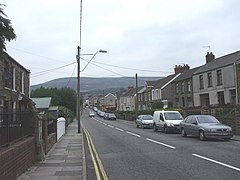
51:Bridgend Road, Garth, 2008
841:
723:
655:. London: Penguin Group.
297:
257:
217:
56:
44:
21:Human settlement in Wales
717:Bridgend County Borough
491:"John Brogden and Sons"
362:Bridgend County Borough
438:
197:Postcode district
35:
651:Newman, John (1995).
436:
145:Preserved county
587:welshcoalmines.co.uk
531:welshcoalmines.co.uk
177:Sovereign state
1225:Scheduled Monuments
336: /
127:Principal area
612:abcrailwayguide.uk
439:
437:St Mary the Virgin
263:UK Parliament
209:Dialling code
1248:
1247:
1199:Listed buildings
1118:Llangynwyd Castle
1098:Candleston Castle
790:Llangynwyd Middle
495:gracesguide.co.uk
453:Buildings of note
398:Cwmdu Canol Farms
355:
354:
1273:
1230:Lord Lieutenants
1123:Newcastle Castle
847:
830:St Bride's Minor
805:Newcastle Higher
785:Llangynwyd Lower
765:Coychurch Higher
710:
703:
696:
687:
682:
677:Jones, D. R. L.
666:
638:
632:
623:
622:
620:
618:
604:
598:
597:
595:
593:
579:
568:
567:
565:
563:
548:
542:
541:
539:
537:
523:
506:
505:
503:
501:
487:
360:is a village in
351:
350:
348:
347:
346:
341:
340:51.602°N 3.640°W
337:
334:
333:
332:
329:
303:
271:Aberafan Maesteg
171:
105:
104:
82:Location within
72:
71:
65:
49:
24:
1281:
1280:
1276:
1275:
1274:
1272:
1271:
1270:
1251:
1250:
1249:
1244:
1190:Electoral wards
1163:
1132:
1086:
854:
848:
839:
770:Coychurch Lower
728:
719:
714:
676:
673:
671:Further reading
663:
650:
647:
642:
641:
633:
626:
616:
614:
606:
605:
601:
591:
589:
581:
580:
571:
561:
559:
550:
549:
545:
535:
533:
525:
524:
509:
499:
497:
489:
488:
477:
472:
455:
431:
406:long depression
382:
344:
342:
338:
335:
330:
327:
325:
323:
322:
321:
301:
293:
275:
167:
157:
139:
121:
100:
99:
89:
88:
87:
86:
80:
79:
78:
77:
73:
52:
40:
22:
17:
12:
11:
5:
1279:
1277:
1269:
1268:
1263:
1253:
1252:
1246:
1245:
1243:
1242:
1237:
1232:
1227:
1222:
1217:
1212:
1211:
1210:
1205:
1197:
1192:
1187:
1182:
1177:
1171:
1169:
1165:
1164:
1162:
1161:
1156:
1151:
1146:
1140:
1138:
1134:
1133:
1131:
1130:
1125:
1120:
1115:
1110:
1105:
1100:
1094:
1092:
1088:
1087:
1085:
1084:
1079:
1074:
1069:
1064:
1062:South Cornelly
1059:
1054:
1049:
1044:
1039:
1034:
1029:
1024:
1019:
1014:
1009:
1004:
1002:North Cornelly
999:
994:
989:
984:
979:
974:
969:
964:
959:
954:
949:
944:
939:
934:
929:
924:
919:
914:
909:
904:
899:
894:
889:
884:
879:
874:
869:
864:
858:
856:
850:
849:
842:
840:
838:
837:
832:
827:
822:
817:
812:
807:
802:
797:
792:
787:
782:
777:
772:
767:
762:
757:
752:
747:
742:
736:
734:
730:
729:
724:
721:
720:
715:
713:
712:
705:
698:
690:
684:
683:
672:
669:
668:
667:
661:
646:
643:
640:
639:
637:, p. 351.
624:
599:
569:
558:. 19 June 1897
543:
507:
474:
473:
471:
468:
454:
451:
430:
427:
381:
378:
353:
352:
345:51.602; -3.640
320:
319:
314:
309:
304:
302:List of places
298:
295:
294:
292:
291:
285:
283:
277:
276:
274:
273:
267:
265:
259:
258:
255:
254:
249:
243:
242:
237:
231:
230:
225:
219:
218:
215:
214:
211:
205:
204:
199:
193:
192:
189:
183:
182:
181:United Kingdom
179:
173:
172:
165:
159:
158:
156:
155:
149:
147:
141:
140:
138:
137:
131:
129:
123:
122:
120:
119:
115:
113:
107:
106:
97:
91:
90:
81:
75:
74:
67:
66:
60:
59:
58:
57:
54:
53:
50:
42:
41:
39:
38:
28:
20:
15:
13:
10:
9:
6:
4:
3:
2:
1278:
1267:
1264:
1262:
1259:
1258:
1256:
1241:
1238:
1236:
1235:High Sheriffs
1233:
1231:
1228:
1226:
1223:
1221:
1218:
1216:
1213:
1209:
1206:
1204:
1201:
1200:
1198:
1196:
1193:
1191:
1188:
1186:
1183:
1181:
1178:
1176:
1173:
1172:
1170:
1166:
1160:
1157:
1155:
1152:
1150:
1147:
1145:
1142:
1141:
1139:
1135:
1129:
1128:Ogmore Castle
1126:
1124:
1121:
1119:
1116:
1114:
1113:Kenfig Castle
1111:
1109:
1108:Ewenny Priory
1106:
1104:
1101:
1099:
1096:
1095:
1093:
1089:
1083:
1080:
1078:
1075:
1073:
1070:
1068:
1065:
1063:
1060:
1058:
1055:
1053:
1050:
1048:
1045:
1043:
1040:
1038:
1035:
1033:
1030:
1028:
1025:
1023:
1020:
1018:
1015:
1013:
1010:
1008:
1005:
1003:
1000:
998:
995:
993:
990:
988:
985:
983:
980:
978:
975:
973:
970:
968:
965:
963:
960:
958:
955:
953:
950:
948:
945:
943:
940:
938:
935:
933:
930:
928:
925:
923:
920:
918:
915:
913:
910:
908:
905:
903:
900:
898:
895:
893:
890:
888:
885:
883:
880:
878:
875:
873:
870:
868:
865:
863:
860:
859:
857:
851:
846:
836:
833:
831:
828:
826:
823:
821:
818:
816:
813:
811:
810:Ogmore Valley
808:
806:
803:
801:
798:
796:
793:
791:
788:
786:
783:
781:
778:
776:
773:
771:
768:
766:
763:
761:
758:
756:
753:
751:
748:
746:
743:
741:
738:
737:
735:
731:
727:
722:
718:
711:
706:
704:
699:
697:
692:
691:
688:
680:
675:
674:
670:
664:
658:
654:
649:
648:
644:
636:
631:
629:
625:
613:
609:
603:
600:
588:
584:
578:
576:
574:
570:
557:
553:
547:
544:
532:
528:
522:
520:
518:
516:
514:
512:
508:
496:
492:
486:
484:
482:
480:
476:
469:
467:
465:
460:
452:
450:
448:
444:
435:
428:
426:
422:
418:
414:
412:
407:
403:
399:
395:
390:
388:
379:
377:
375:
374:Llynfi Valley
371:
367:
363:
359:
349:
318:
315:
313:
310:
308:
305:
300:
299:
296:
290:
287:
286:
284:
282:
272:
269:
268:
266:
264:
256:
253:
250:
248:
241:
238:
236:
229:
226:
224:
212:
210:
203:
200:
198:
190:
188:
180:
178:
170:
166:
164:
154:
153:Mid Glamorgan
151:
150:
148:
146:
136:
133:
132:
130:
128:
117:
116:
114:
112:
103:
98:
96:
85:
64:
55:
48:
37:
33:
30:
29:
25:
19:
1159:River Ogmore
1154:River Llynfi
1144:Ewenny River
1103:Coity Castle
987:Merthyr Mawr
931:
800:Merthyr Mawr
755:Coity Higher
678:
652:
645:Bibliography
615:. Retrieved
611:
602:
590:. Retrieved
586:
560:. Retrieved
555:
546:
534:. Retrieved
530:
498:. Retrieved
494:
456:
440:
423:
419:
415:
397:
393:
391:
387:River Llynfi
383:
357:
356:
18:
1175:Communities
1012:Ogmore Vale
992:Nant-y-moel
947:Kenfig Hill
775:Garw Valley
750:Cefn Cribwr
733:Communities
635:Newman 1995
556:Weekly Mail
343: /
240:South Wales
228:South Wales
1255:Categories
1240:Public art
1149:River Garw
1072:Tythegston
1047:Price Town
1037:Pontycymer
1022:Pantyrawel
972:Llangynwyd
967:Llangeinor
937:Heol-y-Cyw
902:Cefn Cross
892:Bryntirion
882:Bryncethin
862:Aberkenfig
662:0140710566
470:References
402:coke ovens
394:Garth Fach
328:51°36′07″N
1208:Grade II*
1077:Wild Mill
1042:Porthcawl
1027:Pen-y-fai
927:Danygraig
917:Coytrahen
912:Coychurch
887:Brynmenyn
872:Blackmill
853:Towns and
835:Ynysawdre
820:Porthcawl
653:Glamorgan
459:grisaille
429:Transport
331:3°38′24″W
247:Ambulance
187:Post town
111:Community
1017:Pantygog
957:Litchard
952:Laleston
922:Cwmfelin
877:Bridgend
855:villages
780:Laleston
760:Cornelly
745:Bridgend
317:Bridgend
135:Bridgend
102:SS865905
84:Bridgend
1266:Maesteg
1203:Grade I
1195:Schools
1091:Castles
1082:Wyndham
1032:Pencoed
1007:Nottage
982:Maesteg
977:Maudlam
962:Llangan
815:Pencoed
795:Maesteg
740:Brackla
617:7 April
592:7 April
562:7 April
536:7 April
500:7 April
380:History
370:Maesteg
191:MAESTEG
163:Country
118:Maesteg
1185:Places
1168:Topics
1137:Rivers
997:Newton
942:Kenfig
897:Caerau
867:Bettws
659:
464:pulpit
289:Ogmore
223:Police
1220:SSSIs
1067:Tondu
932:Garth
907:Coity
447:Garth
443:A4063
366:Wales
358:Garth
312:Wales
252:Welsh
213:01656
169:Wales
76:Garth
36:Garth
32:Welsh
27:Garth
1057:Sarn
1052:Pyle
825:Pyle
657:ISBN
619:2016
594:2016
564:2016
538:2016
502:2016
411:coal
396:and
235:Fire
202:CF34
1257::
627:^
610:.
585:.
572:^
554:.
529:.
510:^
493:.
478:^
413:.
364:,
307:UK
34::
709:e
702:t
695:v
681:.
665:.
621:.
596:.
566:.
540:.
504:.
Text is available under the Creative Commons Attribution-ShareAlike License. Additional terms may apply.