34:
33:
44:
186:
370:
335:
at
Geitungen Lighthouse was the first diaphone installed in Norway. Geitungen was automated and depopulated in 1994, and was listed as a protected site in 1998. The protected site includes the lighthouse and three technical buildings.
287:
lies about 3 kilometres (1.9 mi) northeast of the lighthouse. The island is accessible only by boat. The lighthouse was established in 1924 and it was automated in 1994. It was listed as a protected site in 1998.
304:
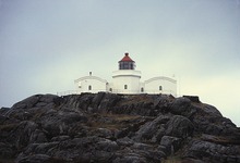
tower. The concrete masonry tower is attached to a U-shaped one-story lighthouse keeper's house. The lighthouse is painted white and the roof is red. The lighthouse also emits a
446:
308:
signal, using the morse code letter "G". The racon signal can be received inside a 1.13-nautical-mile (2.09 km; 1.30 mi) radius of the lighthouse.
477:
598:
572:
670:
680:
633:
515:
502:
675:
498:
345:
83:
388:
279:. The lighthouse is located on a small island about 1 kilometre (0.62 mi) off the southern tip of the main island of
76:
602:
576:
300:
once every six seconds. The light sits at an elevation of 41 metres (135 ft) above sea level on top of an
317:
420:
383:
43:
296:
The 11-metre (36 ft) tall lighthouse emits a white, red or green light, depending on direction,
229:
185:
324:
264:
256:
685:
280:
629:
511:
344:
The living house associated with
Geitungen Lighthouse is operated as a tourist station by the
179:
411:
301:
297:
521:
664:
375:
284:
323:
Geitungen
Lighthouse was designed by Jørgen H. Meinich, who later also designed
469:
358:). It has 35 beds available for visitors. The site is only accessible by boat.
365:
98:
85:
349:
268:
61:
332:
272:
65:
550:
328:
276:
69:
305:
194:
626:
DNTs årbok 2012. Dine hytter – Del 2. Sør for
Jotunheimen
415:
316:
The lighthouse was established in 1924 as a replacement for
652:
470:"Lighthouses of Norway: Haugesund Area (Northern Rogaland)"
628:(in Norwegian). Den Norske Turistforening. p. 175.
327:. The argument for a new location, was the need for a
238:
228:
220:
212:
207:
193:
175:
167:
159:
151:
143:
135:
127:
119:
114:
75:
57:
353:
601:(in Norwegian). Riksantikvaren. Archived from
575:(in Norwegian). Riksantikvaren. Archived from
441:
439:
624:Rogn, Hallgrim, ed. (2012). "Geitungen Fyr".
544:
542:
283:. The entrance to the harbor of the town of
8:
24:
478:University of North Carolina at Chapel Hill
449:(in Norwegian). Norsk Fyrhistorisk Forening
184:
42:
23:
320:, which had operated from 1799 to 1924.
400:
406:
404:
7:
224:17 nmi (31 km; 20 mi)
424:(in Norwegian). Norsk nettleksikon
14:
368:
32:
468:Rowlett, Russ (19 July 2011).
346:Norwegian Trekking Association
1:
671:Lighthouses completed in 1924
389:List of lighthouses in Norway
163:white tower, red lantern roof
681:Listed lighthouses in Norway
16:Coastal lighthouse in Norway
653:Norsk Fyrhistorisk Forening
553:(in Norwegian). Coast Alive
702:
246:
203:
53:
41:
474:The Lighthouse Directory
355:Haugesund Turistforening
292:Technical specifications
171:Haugesund Turistforening
147:11.2 metres (37 ft)
676:Lighthouses in Rogaland
267:in the municipality of
216:41 metres (135 ft)
599:"Geitungen fyrstasjon"
549:Ersland, Bjørn Arild.
447:"Geitungen fyrstasjon"
354:
260:
573:"Skudenes fyrstasjon"
421:Store norske leksikon
384:Lighthouses in Norway
504:Norske Fyrliste 2014
253:Geitungen Lighthouse
99:59.13139°N 5.24278°E
48:Geitungen Lighthouse
28:Geitungen Fyrstasjon
25:Geitungen Lighthouse
318:Skudenes Lighthouse
95: /
38:
325:Makkaur Lighthouse
265:coastal lighthouse
635:978-82-8279-004-8
412:Godal, Anne Marit
250:
249:
180:cultural property
104:59.13139; 5.24278
693:
657:
640:
639:
621:
615:
614:
612:
610:
595:
589:
588:
586:
584:
569:
563:
562:
560:
558:
546:
537:
536:
534:
532:
526:
520:. Archived from
510:(in Norwegian).
509:
495:
489:
488:
486:
484:
465:
459:
458:
456:
454:
443:
434:
433:
431:
429:
408:
378:
373:
372:
371:
357:
189:
188:
110:
109:
107:
106:
105:
100:
96:
93:
92:
91:
88:
46:
39:
37:
36:
701:
700:
696:
695:
694:
692:
691:
690:
661:
660:
655:
649:
644:
643:
636:
623:
622:
618:
608:
606:
605:on 12 July 2013
597:
596:
592:
582:
580:
579:on 12 July 2013
571:
570:
566:
556:
554:
551:"Geitungen fyr"
548:
547:
540:
530:
528:
527:on 12 June 2018
524:
518:
507:
497:
496:
492:
482:
480:
467:
466:
462:
452:
450:
445:
444:
437:
427:
425:
416:"Geitungen fyr"
410:
409:
402:
397:
374:
369:
367:
364:
342:
340:Tourist station
314:
302:octagonal prism
294:
183:
155:octagonal tower
103:
101:
97:
94:
89:
86:
84:
82:
81:
68:
64:
49:
30:
26:
22:
17:
12:
11:
5:
699:
697:
689:
688:
683:
678:
673:
663:
662:
659:
658:
656:(in Norwegian)
648:
647:External links
645:
642:
641:
634:
616:
590:
564:
538:
516:
490:
460:
435:
399:
398:
396:
393:
392:
391:
386:
380:
379:
363:
360:
348:, through its
341:
338:
313:
310:
293:
290:
248:
247:
244:
243:
240:
236:
235:
232:
230:Characteristic
226:
225:
222:
218:
217:
214:
210:
209:
205:
204:
201:
200:
197:
191:
190:
177:
173:
172:
169:
165:
164:
161:
157:
156:
153:
149:
148:
145:
141:
140:
137:
133:
132:
129:
125:
124:
121:
117:
116:
112:
111:
79:
73:
72:
59:
55:
54:
51:
50:
47:
20:
15:
13:
10:
9:
6:
4:
3:
2:
698:
687:
684:
682:
679:
677:
674:
672:
669:
668:
666:
654:
651:
650:
646:
637:
631:
627:
620:
617:
604:
600:
594:
591:
578:
574:
568:
565:
552:
545:
543:
539:
523:
519:
517:9788245015959
513:
506:
505:
500:
494:
491:
479:
475:
471:
464:
461:
448:
442:
440:
436:
423:
422:
417:
413:
407:
405:
401:
394:
390:
387:
385:
382:
381:
377:
376:Norway portal
366:
361:
359:
356:
351:
347:
339:
337:
334:
330:
326:
321:
319:
311:
309:
307:
303:
299:
291:
289:
286:
282:
278:
274:
270:
266:
262:
261:Geitungen fyr
258:
254:
245:
241:
237:
233:
231:
227:
223:
219:
215:
211:
206:
202:
198:
196:
192:
187:
181:
178:
174:
170:
166:
162:
158:
154:
150:
146:
142:
138:
134:
131:masonry tower
130:
126:
122:
118:
113:
108:
80:
78:
74:
71:
67:
63:
60:
56:
52:
45:
40:
35:
29:
19:
625:
619:
607:. Retrieved
603:the original
593:
581:. Retrieved
577:the original
567:
555:. Retrieved
529:. Retrieved
522:the original
503:
493:
481:. Retrieved
473:
463:
451:. Retrieved
426:. Retrieved
419:
343:
322:
315:
295:
285:Skudeneshavn
252:
251:
213:Focal height
128:Construction
27:
18:
120:Constructed
102: /
77:Coordinates
665:Categories
609:6 December
583:6 December
557:6 December
531:2 December
499:Kystverket
483:1 December
453:5 February
428:5 February
395:References
239:Norway no.
234:Oc WRG 6s.
90:05°14′34″E
87:59°07′53″N
21:Lighthouse
352:chapter (
350:Haugesund
298:occulting
257:Norwegian
136:Automated
501:(2014).
362:See also
333:diaphone
275:county,
273:Rogaland
176:Heritage
168:Operator
160:Markings
66:Rogaland
58:Location
414:(ed.).
329:foghorn
312:History
263:) is a
686:Karmøy
632:
514:
331:. The
281:Karmøy
277:Norway
269:Karmøy
242:126500
182:
144:Height
70:Norway
62:Karmøy
525:(PDF)
508:(PDF)
306:racon
221:Range
208:Light
195:Racon
152:Shape
115:Tower
31:
630:ISBN
611:2015
585:2015
559:2015
533:2015
512:ISBN
485:2015
455:2012
430:2012
139:1994
123:1924
271:in
667::
541:^
476:.
472:.
438:^
418:.
403:^
259::
638:.
613:.
587:.
561:.
535:.
487:.
457:.
432:.
255:(
199:G
Text is available under the Creative Commons Attribution-ShareAlike License. Additional terms may apply.