606:
617:
1156:
595:
493:
1168:
859:
835:
812:
797:
782:
692:
70:
1180:
1144:
1192:
1216:
1204:
1275:
1247:
1228:
3752:
1261:
702:
3762:
77:
671:. The settlers built a lighthouse and dwellings and attempted to cultivate plants. However, due to the island's harsh conditions, including its dry climate and the impact of seabirds, most of these efforts were unsuccessful. Meyerton's population was recorded as three American civilians in the 1940 U.S.
1120:
In the northeast section of the island, which appears to have been the main camp area during the military occupation, the remains of several buildings and heavy equipment are still visible. Five wooden antenna poles, each approximately 40 feet (12 metres) tall, continue to stand. Additionally, debris
1087:
Public access to Baker Island is highly restricted and requires a special use permit issued by the U.S. Fish and
Wildlife Service. Permits are typically granted only to scientists and educators. Although there are limited tour packages available from early June to mid-August, unauthorized visits, as
643:
set up temporary camps on Baker Island. On
December 7, 1886, the American Guano Company sold its rights to the British firm John T. Arundel and Company. The company then used Baker Island as its headquarters for guano operations in the Pacific from 1886 to 1891. Believing that the U.S. had abandoned
917:
NRN-1, served as a critical navigation aid for U.S. military operations in the
Pacific during and immediately after World War II. LORAN stations like the one on Baker Island were part of a network used to assist ships and aircraft in determining their positions accurately, particularly in the vast
1044:
established the Baker Island
National Wildlife Refuge. In 2009, the refuge was expanded to include submerged lands extending 12 nautical miles (22 km) from the island's shoreline. The refuge now encompasses 531 acres (215 hectares) of land and 410,184 acres (165,996 hectares) of surrounding
1132:, are scattered throughout the north-central portion and along the northern edge of the island. The U.S. Navy reported the loss of 11 landing craft in the surf during the wartime operations, contributing to the debris found in the waters surrounding the island.
1104:
Debris from past human activity, particularly from the U.S. military's occupation of Baker island during World War II, is scattered across the island and in the surrounding offshore waters. The most prominent remnant is the 5,400-by-150-foot (1,646-by-46-metre)
1109:, which is now completely overgrown with vegetation and is unusable. On the western coast of the island, a day beacon remains from the wartime era, although it has not been maintained since World War II. This beacon is now primarily used by albatross birds and
1631:
Quan
Bautista, Jesi; Smith, Savannah (2018). Early Cultural and Historical Seascape of the Pacific Remote Islands Marine National Monument: Archival and Literary Research Report (Report). NOAA Fisheries Pacific Islands Fisheries Science Center. p. 3.
54:
2530:
900:
fighters from Baker Island's airfield from
September 1 to November 27, 1943. However, the strategic importance of the airfield diminished quickly, and by January 1, 1944, it was abandoned as military operations shifted further west.
540:
deposits were mined by the
American Guano Company from 1859 until 1878. Workers from various parts of the Pacific, including Hawaiʻi, were brought in for the mining operations. The Hawaiian laborers referred to Baker Island as
2523:
2205:
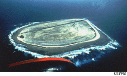
3806:
2516:
1594:
1092:
is restricted to scientists affiliated with the U.S. Fish and
Wildlife Service. Agency representatives visit the island approximately once every two years, often coordinating transportation with a
529:, where he reportedly buried an American seaman. Captain Baker formerly claimed the island in 1855 and subsequently sold his interest to a group that later established the American Guano Company.
2198:
3486:
2713:
3172:
3801:
3589:
3583:
2191:
2497:
2492:
2487:
2482:
2477:
2470:
2465:
2460:
2455:
2450:
2445:
2440:
2435:
2430:
2425:
2420:
2415:
2410:
2405:
2400:
2395:
2390:
2385:
2380:
2375:
2370:
2365:
2360:
2355:
2350:
2345:
2340:
2335:
2330:
2325:
2320:
2315:
2310:
2305:
2300:
2295:
2290:
2285:
2280:
2275:
2270:
2265:
2260:
2255:
2250:
2245:
2240:
2235:
2230:
2225:
2214:
652:
it. The U.S. reasserted its claim in the early 1920s, and after diplomatic discussions, they initiated the
American Equatorial Islands Colonization Project in 1935. In May 1936,
2729:
876:
during World War II. By
September 1943, the Army had constructed a 5,463-foot (1,665 m) airfield on the island. This airfield served as a crucial staging base for the
2605:
118:
3126:
934:
and inhospitable environment. The island, which is over 3700 feet wide, is remote and completely uninhabited, despite its historical significance. It is designated as a
675:. The settlement was eventually evacuated in 1942 following Japanese attacks during World War II, and the island was subsequently occupied by the U.S. military forces.
3116:
636:
626:
2564:
3509:
2706:
2574:
2559:
2022:
1093:
1050:
3165:
420:
A cemetery and remnants from previous settlements are located near the middle of Baker Island's west coast, where the boat landing area is situated. There are no
1584:
3492:
2140:
2078:
3796:
1770:
3202:
2699:
522:
Michael Baker, who visited it in 1834. Some accounts suggest that Baker visited the island earlier, in 1832, and returned on August 14, 1839, aboard the
3765:
3755:
3345:
3158:
3811:
1314:
1167:
2610:
1562:
1038:
393:
1088:
well as activities such as swimming, fishing, and lighting fires, are strictly prohibited. The atoll is only visited during daylight hours, and
3609:
1179:
3197:
1927:
1143:
3639:
3050:
2543:
2539:
1309:
1288:
1155:
723:
401:
913:(Long Range Navigation) radio station on Baker operated from September 1944 until July 1946. This station, designated as Unit 91 with the
2015:"Establishment of the Pacific Remote Islands Marine National Monument: A Proclamation by the President of the United States of America"
1215:
1203:
2048:
69:
1743:
551:. The scale of guano extraction can be illustrated by ship movements in late 1868, where several ships, including the British vessel
369:, characterized by average temperatures around 80 °F (27 °C), minimal rainfall, persistent winds, and strong sunlight. The
2551:
2107:
1825:
1800:
1453:
1342:
648:
in 1897 for a license to work the island. While the United Kingdom considered Baker Island a British territory, they never formally
2173:
3561:
3515:
3462:
3181:
3012:
1385:
362:
Covering an area of 0.81 sq mi (2.1 km), with 3.0 mi (4.8 km) of coastline, Baker Island experiences an
348:
209:
3498:
432:
surrounding Baker Island presents a significant maritime hazard, making access to the shore difficult. To aid in navigation, a
3621:
3615:
1690:
1293:
1049:
as part of the Pacific Remote Islands National Wildlife Refuge Complex. In January 2009, this entity was redesignated as the
1046:
266:
1910:
1866:
605:
446:, which measures 5,463 ft (1,665 m) in length, is now completely overgrown with vegetation and is unserviceable.
1191:
31:
3541:
3212:
3040:
731:
1227:
1712:
1395:
1304:
881:
616:
738:
2014:
2129:
2071:
1408:
473:
1818:
History of United States Naval Operations in World War II: Aleutians, Gilberts and Marshalls, June 1942-April 1944
3816:
3134:
2679:
2072:"Baker Island National Wildlife Refuge: Draft Comprehensive Conservation Plan and Environmental Assessment §3.12"
1298:
511:
492:
3547:
3030:
2592:
2508:
1961:
1988:
450:
2130:"Baker Island National Wildlife Refuge: Draft Comprehensive Conservation Plan and Environmental Assessment"
594:
3791:
3700:
2657:
1522:
Thursday, July 1, ... Howland Island was using the 10+30 hour time zone—the same as Hawaii standard time.
962:
668:
3786:
3237:
1682:
1558:
998:
893:
344:
270:
1744:"Sixteenth Census of the United States: Population, Volume I, Number of Inhabitants, Hawaii (Table 4)"
3422:
3365:
3351:
3249:
2788:
1747:
1280:
1010:
981:. The island is home to over one million seabirds, including significant populations of albatrosses.
811:
397:
858:
834:
796:
781:
476:. Today, the island remains uninhabited, and its time zone is unspecified, though it falls within a
3718:
3448:
3434:
3336:
3318:
3255:
3231:
3225:
3139:
958:
897:
873:
664:
389:
3428:
3389:
3377:
3310:
3304:
3283:
3271:
3265:
3259:
3108:
2973:
2183:
2177:
1589:
1390:
1252:
1002:
970:
477:
458:
363:
1446:
Isles of Amnesia: The History, Geography, and Restoration of America's Forgotten Pacific Islands
1335:
Isles of Amnesia: The History, Geography, and Restoration of America's Forgotten Pacific Islands
3635:
3535:
3442:
3413:
3407:
3289:
3277:
3243:
3207:
1821:
1796:
1449:
1338:
1060:
Environmental challenges facing the refuge include remnants of abandoned military debris from
990:
877:
533:
872:
On August 11, 1943, a U.S. Army defense force arrived on Baker Island as part of the broader
3395:
3383:
3371:
3330:
3298:
3004:
2998:
2898:
2582:
2044:
1633:
1494:
1069:
1006:
889:
2691:
3652:
3603:
3401:
2103:
1914:
1065:
1018:
1014:
986:
653:
645:
1466:
663:
As part of the colonization effort, American settlers arrived on Baker Island aboard the
17:
510:, who named the island "New Nantucket". In August 1825, it was sighted again by Captain
3706:
3688:
3682:
3578:
3529:
3359:
3324:
3088:
3073:
3063:
3020:
2938:
2903:
2627:
2617:
2010:
1266:
1054:
982:
935:
691:
356:
352:
340:
1246:
481:
409:
243:
3780:
3724:
3676:
3658:
3597:
3565:
3093:
3068:
2978:
2883:
2843:
2665:
2642:
2622:
1117:
for the U.S. Fish and Wildlife Service during their infrequent visits to the atoll.
1041:
454:
429:
374:
328:
197:
106:
404:
and, along with Howland Island, is among the last places on Earth to experience the
3736:
3712:
3694:
3664:
3150:
3083:
3078:
2943:
2933:
2928:
2908:
2637:
2632:
1687:"Memorandum of Secretary of State Cordell Hull to the president, February 18, 1936"
1678:
1659:
The loss of the British ship Shaftsbury, Pacific Commercial Advertiser, 12 Jun 1869
1089:
1061:
974:
465:
440:
1686:
1420:
1260:
1750:, 1940; Washington, D.C.; page 1211,. Retrieved on October 29, 2021.
1650:
Baker's Island Report, H.L.R. Johnson, Pacific Commercial Advertiser, 19 Dec 1868
3730:
3521:
3481:
3192:
3098:
3035:
2858:
2773:
2647:
2018:
1907:
1870:
1841:
1110:
1026:
966:
927:
657:
548:
53:
701:
532:
The United States officially took possession of Baker Island in 1857 under the
2893:
2888:
2763:
1242:
1129:
1084:, which were first introduced to the island in 1937, were eradicated by 1965.
1081:
994:
978:
885:
649:
433:
1762:
1355:
1045:
marine waters. Baker Island, along with six other islands, is managed by the
753:
740:
388:
Today, Baker Island is part of the Baker Island National Wildlife Refuge, an
133:
120:
2983:
2948:
2853:
2828:
1842:"Baker Island | Wildlife Sanctuary, Uninhabited, Pacific Ocean | Britannica"
1122:
1106:
1073:
1022:
914:
571:
560:
501:
382:
234:
2168:
1356:"Baker, Howland, and Jarvis Islands | Facts & Information | Infoplease"
412:. It is one of the most remote U.S. possessions in the equatorial Pacific.
1720:
938:
and is characterized by sparse vegetation, including four types of grass,
500:
Baker Island was first discovered in 1818 by Captain Elisha Folger of the
291:
2968:
2918:
2873:
2863:
2848:
2838:
2823:
2803:
2778:
2768:
2758:
1668:
Report from the guano islands, Pacific Commercial Advertiser, 25 Dec 1869
1559:"GAO/OGC-98-5 - U.S. Insular Areas: Application of the U.S. Constitution"
1114:
405:
332:
2988:
2963:
2868:
2808:
2783:
2753:
2743:
1637:
1585:"The Guano Companies in Litigation--A Case of Interest to Stockholders"
1128:
Numerous bulldozer excavations, containing remnants of metal, fuel and
1077:
947:
931:
640:
579:
519:
370:
366:
324:
2923:
2878:
2818:
2793:
2748:
672:
575:
523:
504:
469:
443:
425:
378:
336:
1984:
1953:
1421:"Howland Island | Wildlife, Coral Reefs & Lagoons | Britannica"
392:
and unorganized territory of the U.S. The island is managed by the
2953:
2833:
2798:
1121:
from several crashed aircraft, along with large equipment such as
951:
943:
910:
537:
491:
320:
428:
on the island, and offshore anchorage is prohibited. The narrow,
3475:
3025:
2958:
2913:
2813:
946:. The treeless landscape provides a crucial habitat for various
939:
625:
Settlers erected makeshift campsites on Baker Island during the
518:, another Nantucket whaler. The island later took its name from
468:
attempt from 1935 to 1942, Baker Island was likely operating on
421:
3154:
2695:
2512:
2187:
1315:
List of lighthouses in the United States Minor Outlying Islands
1448:. University of Hawai'i Press, Latitude 20. Pages 38 and 104.
381:, with its highest point being 26 ft (7.9 m) above
3807:
Important Bird Areas of United States Minor Outlying Islands
331:, approximately 1,920 miles (3,090 kilometres) southwest of
884:
bombers to launch attacks on Japanese positions, including
400:
purposes. Statistically, Baker Island is grouped with the
58:
U.S. Fish and Wildlife Service aerial view of Baker Island
1618:
American Polynesia: coral islands of the Central Pacific
2137:
Pacific Remote Islands National Wildlife Refuge Complex
1896:. Vol. II. Public Health Division. August 1, 1946.
1883:
LORAN STATION BAKER ISLAND 0 11 46.23 N 176 28 26.14 W
1337:. University of Hawai'i Press, Latitude 20. Page 110.
347:. Both Baker and Howland Islands have been claimed as
1561:. U.S. Government Printing Office. November 7, 1997.
574:
on Baker's Island reef after a sudden wind shift and
930:
sources and receives minimal rainfall, making it an
918:
and often featureless expanse of the Pacific Ocean.
436:is positioned near the site of the former village.
3125:
3107:
3049:
3011:
2997:
2736:
2656:
2591:
2573:
2550:
1125:, can be found both on the island and underwater.
851:
846:
827:
819:
804:
789:
774:
769:
730:
715:
377:. Unlike many atolls, Baker Island lacks a central
286:
278:
233:
228:
220:
215:
205:
189:
181:
173:
165:
157:
149:
112:
102:
97:
44:
2606:Caribbean Islands National Wildlife Refuge Complex
1985:"Welcome to Baker Island National Wildlife Refuge"
1689:. Hyde Park, N.Y.: Franklin D. Roosevelt Library.
667:on April 3, 1935, establishing a settlement named
3802:Uninhabited Pacific islands of the United States
3564:and other inhabited territories governed by the
637:American Equatorial islands Colonization Project
627:American Equatorial Islands Colonization Project
2045:"Baker Island National Wildlife Refuge History"
1386:"United States Pacific Island Wildlife Refuges"
1051:Pacific Remote Islands Marine National Monument
461:of 12 nmi (22 km) around the Island.
2215:National Wildlife Refuges of the United States
1536:Of islands and men: studies in Pacific history
542:
3166:
2707:
2600:
2524:
2199:
1820:. University of Illinois Press. p. 214.
1620:. Honolulu, Hawaii: Tongg Publishing Company.
1001:, visit the island seasonally. Additionally,
89:Location of Baker Island in the Pacific Ocean
8:
1763:"Lighthouses of U.S. Pacific Remote Islands"
1489:
1487:
1301:, includes coverage of the Howland-Baker EEZ
1221:Landing craft wreckage on Baker Island coast
1209:Brown noddies with radio masts in background
1185:Settlement remains, radio mast in background
1149:Baker Island coastline with red-footed booby
686:
39:
1771:University of North Carolina at Chapel Hill
1029:, can be found along the surrounding reef.
586:was destroyed by fire while loading guano.
373:is flat and sandy, surrounded by a narrow,
3173:
3159:
3151:
2714:
2700:
2692:
2531:
2517:
2509:
2206:
2192:
2184:
2176:. This article incorporates material from
1867:"Loran Station Baker - loran-history.info"
1467:"CIA - The World Factbook -- Baker Island"
857:
833:
810:
795:
780:
700:
685:
343:, situated 42 mi (68 km) to the
52:
38:
496:Orthographic projection over Baker Island
2722:Political divisions of the United States
2104:"Baker Island National Wildlife Refuge"
1565:from the original on September 27, 2013
1516:Long, Elgen M.; Long, Marie K. (2000).
1380:
1378:
1376:
1326:
1173:Hermit crabs taking shade in day beacon
1139:
957:Baker Island has been recognized as an
472:time, which was then 10.5 hours behind
339:and Australia, its closest neighbor is
3610:Trust Territory of the Pacific Islands
2025:from the original on February 23, 2011
1113:for breeding, and it also serves as a
1072:introduced by human activity, such as
965:due to its support for large breeding
2169:Baker Island National Wildlife Refuge
1795:. Greenwood Publishing. p. 332.
1520:. Simon & Schuster. p. 206.
874:Gilbert and Marshall Islands campaign
582:. Later that year, the American ship
259:Baker Island National Wildlife Refuge
7:
3761:
2544:United States Minor Outlying Islands
1693:from the original on January 9, 2010
1310:List of islands of the United States
1289:64th Coast Artillery (United States)
724:United States Minor Outlying Islands
402:United States Minor Outlying Islands
335:. Positioned almost halfway between
76:
1991:from the original on March 27, 2012
1068:in offshore waters. Additionally,
566:In February 1869, the British ship
3797:Insular areas of the United States
3198:Organized incorporated territories
2106:. U.S. Fish and Wildlife Service.
2084:from the original on July 19, 2012
2077:. U.S. Fish and Wildlife Service.
2047:. U.S. Fish and Wildlife Service.
1987:. U.S. Fish and Wildlife Service.
1964:from the original on June 17, 2017
1793:World War Two Pacific Island Guide
1518:Amelia Earhart: the mystery solved
1497:. U.S. Fish & Wildlife Service
1080:, have displaced native wildlife.
926:Baker island is devoid of natural
644:its claim, Arundel applied to the
153:2.1 km (0.81 sq mi)
27:Pacific atoll of the United States
25:
2146:from the original on May 11, 2009
2110:from the original on May 16, 2013
2051:from the original on May 28, 2013
1597:from the original on May 10, 2013
656:7358 was issued to reaffirm U.S.
3760:
3751:
3750:
3562:United Nations trust territories
3182:Territories of the United States
2070:Palawski, Donald (August 2007).
1983:White, Susan (August 26, 2011).
1273:
1259:
1245:
1226:
1214:
1202:
1190:
1178:
1166:
1154:
1142:
690:
615:
604:
593:
349:territories of the United States
75:
68:
3812:Important Bird Areas of Oceania
3616:American Concession in Shanghai
559:, transported tons of guano to
277:
3622:American concession of Tianjin
2730:List of states and territories
1934:. BirdLife International. 2021
1294:History of the Pacific Islands
1047:U.S. Fish and Wildlife Service
570:captained by John Davies, was
394:U.S. Fish and Wildlife Service
242:International Date Line West (
1:
1495:"Baker Island : History"
823:cylindrical tower, no lantern
449:The United States asserts an
355:regarded them as part of the
32:Baker Island (disambiguation)
3213:U.S. territorial sovereignty
1233:Baker Island satellite image
578:caused the ship to drag its
396:and is visited annually for
169:1.13 km (0.702 mi)
161:1.81 km (1.125 mi)
3117:List of Indian reservations
2493:U.S. Minor Outlying Islands
1616:Edwin Horace Bryan (1941).
1396:Central Intelligence Agency
1305:List of Guano Island claims
808:5 m (16 ft)
3833:
3463:Unincorporated territories
1538:. Oxford University Press.
1534:Henry Evans Maude (1968).
1197:Masked booby on gravestone
323:located just north of the
319:, is a small, uninhabited
177:4.8 km (2.98 mi)
29:
3746:
3648:
3631:
3574:
3557:
3471:
3458:
3221:
3188:
3127:International concessions
2727:
2680:Office of Insular Affairs
2674:
2593:National Wildlife Refuges
2552:Marine national monuments
2221:
1299:Howland and Baker Islands
1100:Human debris and remnants
1039:Secretary of the Interior
866:
842:
711:
699:
439:Baker Island's abandoned
306:
264:
257:
253:
194:
63:
51:
18:Geography of Baker Island
3548:Northern Mariana Islands
3031:Northern Mariana Islands
1906:U.S. Dept. of Interior.
1816:Morison, Samuel (2001).
1791:Rottman, Gordon (2002).
1767:The Lighthouse Directory
1444:Rauzon, Mark J. (2016).
1409:(Archived 2014 edition.)
1333:Rauzon, Mark J. (2016).
1033:National Wildlife Refuge
954:, and marine wildlife.
1917:Retrieved July 6, 2008.
1913:April 19, 2012, at the
687:Baker Island Day Beacon
646:British Colonial Office
543:
451:exclusive economic zone
359:between 1897 and 1936.
351:since 1857, though the
46:Nickname: New Nantucket
2658:The Nature Conservancy
2560:Pacific Remote Islands
1683:Roosevelt, Franklin D.
1161:Fish and Wildlife sign
999:Pacific golden plovers
963:BirdLife International
555:and the American ship
536:of 1856. The island's
497:
229:Additional information
182:Highest elevation
3203:Territorial evolution
1894:Coast Guard at War IV
969:of seabirds, such as
894:45th Fighter Squadron
754:0.19578°N 176.48428°W
495:
480:12 hours behind UTC (
271:strict nature reserve
185:8 m (26 ft)
134:0.19583°N 176.47917°W
1748:United States census
1281:United States portal
892:. Additionally, the
457:(370 km) and a
453:(EEZ) extending 200
315:, formerly known as
30:For other uses, see
3640:uninhabited islands
3542:U.S. Virgin Islands
3109:Indian reservations
3041:U.S. Virgin Islands
2498:U.S. Virgin Islands
2013:(January 6, 2009).
971:lesser frigatebirds
959:Important Bird Area
905:LORAN Station Baker
759:0.19578; -176.48428
750: /
696:
547:", named after the
410:UTC−12:00 time zone
408:, operating in the
139:0.19583; -176.47917
130: /
41:
2575:National Memorials
2178:The World Factbook
1932:BirdLife Data Zone
1873:on August 24, 2010
1846:www.britannica.com
1638:10.25923/fb5w-jw23
1590:The New York Times
1425:www.britannica.com
1391:The World Factbook
1360:www.infoplease.com
1253:Engineering portal
1037:On June 27, 1974,
991:bar-tailed godwits
985:waders, including
942:, and low-growing
706:Baker Island Light
498:
478:nautical time zone
3774:
3773:
3638:claims and other
3636:Guano Islands Act
3536:Panama Canal Zone
3208:Thirteen Colonies
3148:
3147:
2689:
2688:
2565:Papahānaumokuākea
2506:
2505:
1394:(2024 ed.).
1011:hawksbill turtles
878:Seventh Air Force
870:
869:
534:Guano Islands Act
310:
309:
16:(Redirected from
3824:
3817:Seabird colonies
3764:
3763:
3754:
3753:
3719:Quita Sueño Bank
3299:Indian Territory
3175:
3168:
3161:
3152:
3051:Outlying islands
3005:Washington, D.C.
2999:Federal district
2716:
2709:
2702:
2693:
2666:Palmyra Preserve
2583:Battle of Midway
2533:
2526:
2519:
2510:
2208:
2201:
2194:
2185:
2156:
2155:
2153:
2151:
2145:
2134:
2126:
2120:
2119:
2117:
2115:
2100:
2094:
2093:
2091:
2089:
2083:
2076:
2067:
2061:
2060:
2058:
2056:
2041:
2035:
2034:
2032:
2030:
2007:
2001:
2000:
1998:
1996:
1980:
1974:
1973:
1971:
1969:
1950:
1944:
1943:
1941:
1939:
1924:
1918:
1904:
1898:
1897:
1890:
1884:
1882:
1880:
1878:
1869:. Archived from
1863:
1857:
1856:
1854:
1852:
1838:
1832:
1831:
1813:
1807:
1806:
1788:
1782:
1781:
1779:
1777:
1758:
1752:
1751:
1739:
1733:
1732:
1730:
1728:
1723:on July 23, 2011
1719:. Archived from
1709:
1703:
1702:
1700:
1698:
1675:
1669:
1666:
1660:
1657:
1651:
1648:
1642:
1641:
1628:
1622:
1621:
1613:
1607:
1606:
1604:
1602:
1581:
1575:
1574:
1572:
1570:
1555:
1549:
1546:
1540:
1539:
1531:
1525:
1524:
1513:
1507:
1506:
1504:
1502:
1491:
1482:
1481:
1479:
1477:
1471:user.iiasa.ac.at
1463:
1457:
1442:
1436:
1435:
1433:
1431:
1417:
1411:
1406:
1404:
1402:
1382:
1371:
1370:
1368:
1366:
1352:
1346:
1331:
1283:
1278:
1277:
1276:
1269:
1264:
1263:
1255:
1250:
1249:
1230:
1218:
1206:
1194:
1182:
1170:
1158:
1146:
1070:invasive species
1019:spinner dolphins
1015:gray reef sharks
987:ruddy turnstones
890:Marshall Islands
862:
861:
838:
837:
815:
814:
800:
799:
785:
784:
765:
764:
762:
761:
760:
755:
751:
748:
747:
746:
743:
704:
697:
695:
694:
619:
608:
597:
546:
302:
299:
297:
295:
293:
145:
144:
142:
141:
140:
135:
131:
128:
127:
126:
123:
79:
78:
72:
56:
42:
21:
3832:
3831:
3827:
3826:
3825:
3823:
3822:
3821:
3777:
3776:
3775:
3770:
3742:
3653:Phoenix Islands
3644:
3627:
3604:Volcano Islands
3570:
3553:
3467:
3454:
3217:
3184:
3179:
3149:
3144:
3121:
3103:
3045:
3007:
2993:
2732:
2723:
2720:
2690:
2685:
2670:
2652:
2587:
2569:
2546:
2540:Protected areas
2537:
2507:
2502:
2217:
2212:
2165:
2160:
2159:
2149:
2147:
2143:
2139:. August 2007.
2132:
2128:
2127:
2123:
2113:
2111:
2102:
2101:
2097:
2087:
2085:
2081:
2074:
2069:
2068:
2064:
2054:
2052:
2043:
2042:
2038:
2028:
2026:
2011:Bush, George W.
2009:
2008:
2004:
1994:
1992:
1982:
1981:
1977:
1967:
1965:
1954:"Redirect Page"
1952:
1951:
1947:
1937:
1935:
1926:
1925:
1921:
1915:Wayback Machine
1905:
1901:
1892:
1891:
1887:
1876:
1874:
1865:
1864:
1860:
1850:
1848:
1840:
1839:
1835:
1828:
1815:
1814:
1810:
1803:
1790:
1789:
1785:
1775:
1773:
1761:Rowlett, Russ.
1760:
1759:
1755:
1741:
1740:
1736:
1726:
1724:
1711:
1710:
1706:
1696:
1694:
1677:
1676:
1672:
1667:
1663:
1658:
1654:
1649:
1645:
1630:
1629:
1625:
1615:
1614:
1610:
1600:
1598:
1593:. May 3, 1865.
1583:
1582:
1578:
1568:
1566:
1557:
1556:
1552:
1547:
1543:
1533:
1532:
1528:
1515:
1514:
1510:
1500:
1498:
1493:
1492:
1485:
1475:
1473:
1465:
1464:
1460:
1443:
1439:
1429:
1427:
1419:
1418:
1414:
1400:
1398:
1384:
1383:
1374:
1364:
1362:
1354:
1353:
1349:
1332:
1328:
1323:
1279:
1274:
1272:
1265:
1258:
1251:
1244:
1241:
1234:
1231:
1222:
1219:
1210:
1207:
1198:
1195:
1186:
1183:
1174:
1171:
1162:
1159:
1150:
1147:
1138:
1102:
1066:illegal fishing
1035:
940:prostrate vines
936:wildlife refuge
924:
922:Flora and fauna
915:radio call sign
907:
856:
832:
809:
794:
779:
758:
756:
752:
749:
744:
741:
739:
737:
736:
707:
688:
684:
681:
654:Executive Order
633:
632:
631:
630:
622:
621:
620:
611:
610:
609:
600:
599:
598:
490:
459:territorial sea
418:
345:north-northwest
327:in the central
290:
274:
249:
201:
138:
136:
132:
129:
124:
121:
119:
117:
116:
93:
92:
91:
90:
87:
86:
85:
84:
80:
59:
47:
35:
28:
23:
22:
15:
12:
11:
5:
3830:
3828:
3820:
3819:
3814:
3809:
3804:
3799:
3794:
3789:
3779:
3778:
3772:
3771:
3769:
3768:
3758:
3747:
3744:
3743:
3741:
3740:
3734:
3733:(1899–present)
3728:
3727:(1898–present)
3722:
3716:
3715:(1867–present)
3710:
3709:(1867–present)
3707:Howland Island
3704:
3698:
3697:(1860–present)
3692:
3691:(1858–present)
3689:Navassa Island
3686:
3685:(1858–present)
3683:Johnston Atoll
3680:
3679:(1858–present)
3674:
3673:(1857–present)
3668:
3662:
3656:
3649:
3646:
3645:
3643:
3642:
3632:
3629:
3628:
3626:
3625:
3619:
3613:
3607:
3601:
3595:
3594:
3593:
3587:
3579:Ryukyu Islands
3575:
3572:
3571:
3569:
3568:
3558:
3555:
3554:
3552:
3551:
3550:(1986–present)
3545:
3544:(1917–present)
3539:
3533:
3532:(1899–present)
3530:American Samoa
3527:
3526:
3525:
3519:
3513:
3504:
3503:
3502:
3496:
3490:
3479:
3478:(1898–present)
3472:
3469:
3468:
3466:
3465:
3459:
3456:
3455:
3453:
3452:
3446:
3440:
3439:
3438:
3432:
3426:
3417:
3411:
3405:
3399:
3393:
3387:
3381:
3375:
3369:
3363:
3357:
3356:
3355:
3349:
3340:
3334:
3328:
3322:
3316:
3315:
3314:
3308:
3302:
3293:
3287:
3281:
3275:
3269:
3263:
3253:
3247:
3241:
3235:
3229:
3222:
3219:
3218:
3216:
3215:
3210:
3205:
3200:
3195:
3189:
3186:
3185:
3180:
3178:
3177:
3170:
3163:
3155:
3146:
3145:
3143:
3142:
3137:
3135:Guantanamo Bay
3131:
3129:
3123:
3122:
3120:
3119:
3113:
3111:
3105:
3104:
3102:
3101:
3096:
3091:
3089:Navassa Island
3086:
3081:
3076:
3074:Johnston Atoll
3071:
3066:
3064:Howland Island
3061:
3055:
3053:
3047:
3046:
3044:
3043:
3038:
3033:
3028:
3023:
3021:American Samoa
3017:
3015:
3009:
3008:
3003:
3001:
2995:
2994:
2992:
2991:
2986:
2981:
2976:
2971:
2966:
2961:
2956:
2951:
2946:
2941:
2939:South Carolina
2936:
2931:
2926:
2921:
2916:
2911:
2906:
2904:North Carolina
2901:
2896:
2891:
2886:
2881:
2876:
2871:
2866:
2861:
2856:
2851:
2846:
2841:
2836:
2831:
2826:
2821:
2816:
2811:
2806:
2801:
2796:
2791:
2786:
2781:
2776:
2771:
2766:
2761:
2756:
2751:
2746:
2740:
2738:
2734:
2733:
2728:
2725:
2724:
2721:
2719:
2718:
2711:
2704:
2696:
2687:
2686:
2684:
2683:
2675:
2672:
2671:
2669:
2668:
2662:
2660:
2654:
2653:
2651:
2650:
2645:
2640:
2635:
2630:
2628:Johnston Atoll
2625:
2620:
2618:Howland Island
2615:
2614:
2613:
2611:Navassa Island
2603:
2597:
2595:
2589:
2588:
2586:
2585:
2579:
2577:
2571:
2570:
2568:
2567:
2562:
2556:
2554:
2548:
2547:
2538:
2536:
2535:
2528:
2521:
2513:
2504:
2503:
2501:
2500:
2495:
2490:
2485:
2480:
2478:American Samoa
2474:
2473:
2468:
2463:
2458:
2453:
2448:
2443:
2438:
2433:
2428:
2423:
2421:South Carolina
2418:
2413:
2408:
2403:
2398:
2393:
2388:
2386:North Carolina
2383:
2378:
2373:
2368:
2363:
2358:
2353:
2348:
2343:
2338:
2333:
2328:
2323:
2318:
2313:
2308:
2303:
2298:
2293:
2288:
2283:
2278:
2273:
2268:
2263:
2258:
2253:
2248:
2243:
2238:
2233:
2228:
2222:
2219:
2218:
2213:
2211:
2210:
2203:
2196:
2188:
2182:
2181:
2171:
2164:
2163:External links
2161:
2158:
2157:
2121:
2095:
2062:
2036:
2002:
1975:
1945:
1928:"Baker Island"
1919:
1899:
1885:
1858:
1833:
1826:
1808:
1801:
1783:
1753:
1734:
1713:"Baker Island"
1704:
1670:
1661:
1652:
1643:
1623:
1608:
1576:
1550:
1541:
1526:
1508:
1483:
1458:
1437:
1412:
1372:
1347:
1325:
1324:
1322:
1319:
1318:
1317:
1312:
1307:
1302:
1296:
1291:
1285:
1284:
1270:
1267:Oceania portal
1256:
1240:
1237:
1236:
1235:
1232:
1225:
1223:
1220:
1213:
1211:
1208:
1201:
1199:
1196:
1189:
1187:
1184:
1177:
1175:
1172:
1165:
1163:
1160:
1153:
1151:
1148:
1141:
1137:
1134:
1101:
1098:
1064:and threat of
1055:George W. Bush
1034:
1031:
975:masked boobies
923:
920:
906:
903:
882:B-24 Liberator
868:
867:
864:
863:
853:
849:
848:
844:
843:
840:
839:
829:
825:
824:
821:
817:
816:
806:
802:
801:
791:
787:
786:
776:
772:
771:
767:
766:
734:
728:
727:
717:
713:
712:
709:
708:
705:
682:
680:
677:
624:
623:
614:
613:
612:
603:
602:
601:
592:
591:
590:
589:
588:
527:Gideon Howland
489:
486:
455:nautical miles
417:
414:
390:unincorporated
357:British Empire
353:United Kingdom
341:Howland Island
308:
307:
304:
303:
288:
284:
283:
280:
276:
275:
265:
262:
261:
255:
254:
251:
250:
248:
247:
239:
237:
231:
230:
226:
225:
222:
218:
217:
213:
212:
210:Unincorporated
207:
203:
202:
195:
192:
191:
190:Administration
187:
186:
183:
179:
178:
175:
171:
170:
167:
163:
162:
159:
155:
154:
151:
147:
146:
114:
110:
109:
104:
100:
99:
95:
94:
88:
82:
81:
74:
73:
67:
66:
65:
64:
61:
60:
57:
49:
48:
45:
26:
24:
14:
13:
10:
9:
6:
4:
3:
2:
3829:
3818:
3815:
3813:
3810:
3808:
3805:
3803:
3800:
3798:
3795:
3793:
3792:Coral islands
3790:
3788:
3785:
3784:
3782:
3767:
3759:
3757:
3749:
3748:
3745:
3738:
3735:
3732:
3729:
3726:
3725:Palmyra Atoll
3723:
3720:
3717:
3714:
3711:
3708:
3705:
3702:
3699:
3696:
3693:
3690:
3687:
3684:
3681:
3678:
3677:Jarvis Island
3675:
3672:
3669:
3666:
3663:
3660:
3659:Roncador Bank
3657:
3654:
3651:
3650:
3647:
3641:
3637:
3634:
3633:
3630:
3623:
3620:
3617:
3614:
3611:
3608:
3605:
3602:
3599:
3598:Bonin Islands
3596:
3591:
3588:
3585:
3582:
3581:
3580:
3577:
3576:
3573:
3567:
3566:United States
3563:
3560:
3559:
3556:
3549:
3546:
3543:
3540:
3537:
3534:
3531:
3528:
3523:
3520:
3517:
3514:
3511:
3508:
3507:
3505:
3500:
3497:
3494:
3491:
3488:
3485:
3484:
3483:
3480:
3477:
3474:
3473:
3470:
3464:
3461:
3460:
3457:
3450:
3447:
3444:
3441:
3436:
3433:
3430:
3427:
3424:
3421:
3420:
3418:
3415:
3412:
3409:
3406:
3403:
3400:
3397:
3394:
3391:
3388:
3385:
3382:
3379:
3376:
3373:
3370:
3367:
3364:
3361:
3358:
3353:
3350:
3347:
3344:
3343:
3341:
3338:
3335:
3332:
3329:
3326:
3323:
3320:
3317:
3312:
3309:
3306:
3303:
3300:
3297:
3296:
3294:
3291:
3288:
3285:
3282:
3279:
3276:
3273:
3270:
3267:
3264:
3261:
3257:
3254:
3251:
3248:
3245:
3242:
3239:
3236:
3233:
3230:
3227:
3224:
3223:
3220:
3214:
3211:
3209:
3206:
3204:
3201:
3199:
3196:
3194:
3191:
3190:
3187:
3183:
3176:
3171:
3169:
3164:
3162:
3157:
3156:
3153:
3141:
3138:
3136:
3133:
3132:
3130:
3128:
3124:
3118:
3115:
3114:
3112:
3110:
3106:
3100:
3097:
3095:
3094:Palmyra Atoll
3092:
3090:
3087:
3085:
3082:
3080:
3077:
3075:
3072:
3070:
3069:Jarvis Island
3067:
3065:
3062:
3060:
3057:
3056:
3054:
3052:
3048:
3042:
3039:
3037:
3034:
3032:
3029:
3027:
3024:
3022:
3019:
3018:
3016:
3014:
3010:
3006:
3002:
3000:
2996:
2990:
2987:
2985:
2982:
2980:
2979:West Virginia
2977:
2975:
2972:
2970:
2967:
2965:
2962:
2960:
2957:
2955:
2952:
2950:
2947:
2945:
2942:
2940:
2937:
2935:
2932:
2930:
2927:
2925:
2922:
2920:
2917:
2915:
2912:
2910:
2907:
2905:
2902:
2900:
2897:
2895:
2892:
2890:
2887:
2885:
2884:New Hampshire
2882:
2880:
2877:
2875:
2872:
2870:
2867:
2865:
2862:
2860:
2857:
2855:
2852:
2850:
2847:
2845:
2844:Massachusetts
2842:
2840:
2837:
2835:
2832:
2830:
2827:
2825:
2822:
2820:
2817:
2815:
2812:
2810:
2807:
2805:
2802:
2800:
2797:
2795:
2792:
2790:
2787:
2785:
2782:
2780:
2777:
2775:
2772:
2770:
2767:
2765:
2762:
2760:
2757:
2755:
2752:
2750:
2747:
2745:
2742:
2741:
2739:
2735:
2731:
2726:
2717:
2712:
2710:
2705:
2703:
2698:
2697:
2694:
2682:
2681:
2677:
2676:
2673:
2667:
2664:
2663:
2661:
2659:
2655:
2649:
2646:
2644:
2643:Palmyra Atoll
2641:
2639:
2636:
2634:
2631:
2629:
2626:
2624:
2623:Jarvis Island
2621:
2619:
2616:
2612:
2609:
2608:
2607:
2604:
2602:
2599:
2598:
2596:
2594:
2590:
2584:
2581:
2580:
2578:
2576:
2572:
2566:
2563:
2561:
2558:
2557:
2555:
2553:
2549:
2545:
2541:
2534:
2529:
2527:
2522:
2520:
2515:
2514:
2511:
2499:
2496:
2494:
2491:
2489:
2486:
2484:
2481:
2479:
2476:
2475:
2472:
2469:
2467:
2464:
2462:
2461:West Virginia
2459:
2457:
2454:
2452:
2449:
2447:
2444:
2442:
2439:
2437:
2434:
2432:
2429:
2427:
2424:
2422:
2419:
2417:
2414:
2412:
2409:
2407:
2404:
2402:
2399:
2397:
2394:
2392:
2389:
2387:
2384:
2382:
2379:
2377:
2374:
2372:
2369:
2367:
2366:New Hampshire
2364:
2362:
2359:
2357:
2354:
2352:
2349:
2347:
2344:
2342:
2339:
2337:
2334:
2332:
2329:
2327:
2326:Massachusetts
2324:
2322:
2319:
2317:
2314:
2312:
2309:
2307:
2304:
2302:
2299:
2297:
2294:
2292:
2289:
2287:
2284:
2282:
2279:
2277:
2274:
2272:
2269:
2267:
2264:
2262:
2259:
2257:
2254:
2252:
2249:
2247:
2244:
2242:
2239:
2237:
2234:
2232:
2229:
2227:
2224:
2223:
2220:
2216:
2209:
2204:
2202:
2197:
2195:
2190:
2189:
2186:
2179:
2175:
2172:
2170:
2167:
2166:
2162:
2142:
2138:
2131:
2125:
2122:
2109:
2105:
2099:
2096:
2080:
2073:
2066:
2063:
2050:
2046:
2040:
2037:
2024:
2020:
2016:
2012:
2006:
2003:
1990:
1986:
1979:
1976:
1963:
1959:
1955:
1949:
1946:
1933:
1929:
1923:
1920:
1916:
1912:
1909:
1908:Baker Island.
1903:
1900:
1895:
1889:
1886:
1872:
1868:
1862:
1859:
1847:
1843:
1837:
1834:
1829:
1827:9780252070372
1823:
1819:
1812:
1809:
1804:
1802:9780313313950
1798:
1794:
1787:
1784:
1772:
1768:
1764:
1757:
1754:
1749:
1745:
1738:
1735:
1722:
1718:
1714:
1708:
1705:
1692:
1688:
1684:
1680:
1679:Hull, Cordell
1674:
1671:
1665:
1662:
1656:
1653:
1647:
1644:
1639:
1635:
1627:
1624:
1619:
1612:
1609:
1596:
1592:
1591:
1586:
1580:
1577:
1564:
1560:
1554:
1551:
1545:
1542:
1537:
1530:
1527:
1523:
1519:
1512:
1509:
1501:September 23,
1496:
1490:
1488:
1484:
1472:
1468:
1462:
1459:
1455:
1454:9780824846794
1451:
1447:
1441:
1438:
1426:
1422:
1416:
1413:
1410:
1397:
1393:
1392:
1387:
1381:
1379:
1377:
1373:
1361:
1357:
1351:
1348:
1344:
1343:9780824846794
1340:
1336:
1330:
1327:
1320:
1316:
1313:
1311:
1308:
1306:
1303:
1300:
1297:
1295:
1292:
1290:
1287:
1286:
1282:
1271:
1268:
1262:
1257:
1254:
1248:
1243:
1238:
1229:
1224:
1217:
1212:
1205:
1200:
1193:
1188:
1181:
1176:
1169:
1164:
1157:
1152:
1145:
1140:
1135:
1133:
1131:
1126:
1124:
1118:
1116:
1112:
1108:
1099:
1097:
1095:
1091:
1085:
1083:
1079:
1078:coconut palms
1075:
1071:
1067:
1063:
1058:
1056:
1053:by President
1052:
1048:
1043:
1042:Rogers Morton
1040:
1032:
1030:
1028:
1024:
1020:
1016:
1013:, as well as
1012:
1008:
1007:green turtles
1005:species like
1004:
1000:
996:
992:
988:
984:
980:
976:
972:
968:
964:
960:
955:
953:
949:
945:
941:
937:
933:
929:
921:
919:
916:
912:
904:
902:
899:
895:
891:
887:
883:
879:
875:
865:
860:
854:
850:
845:
841:
836:
830:
826:
822:
818:
813:
807:
803:
798:
792:
788:
783:
777:
773:
768:
763:
735:
733:
729:
725:
721:
718:
714:
710:
703:
698:
693:
678:
676:
674:
670:
666:
661:
659:
655:
651:
647:
642:
638:
628:
618:
607:
596:
587:
585:
581:
577:
573:
569:
564:
562:
558:
554:
550:
545:
539:
535:
530:
528:
525:
521:
517:
513:
512:Obed Starbuck
509:
506:
503:
494:
487:
485:
483:
479:
475:
471:
467:
462:
460:
456:
452:
447:
445:
442:
437:
435:
431:
430:fringing reef
427:
423:
415:
413:
411:
407:
403:
399:
395:
391:
386:
384:
380:
376:
375:fringing reef
372:
368:
365:
360:
358:
354:
350:
346:
342:
338:
334:
330:
329:Pacific Ocean
326:
322:
318:
317:New Nantucket
314:
305:
301:
300:/baker-island
289:
285:
281:
272:
268:
267:IUCN category
263:
260:
256:
252:
245:
241:
240:
238:
236:
232:
227:
223:
219:
214:
211:
208:
204:
200:
199:
198:United States
193:
188:
184:
180:
176:
172:
168:
164:
160:
156:
152:
148:
143:
115:
111:
108:
107:Pacific Ocean
105:
101:
96:
71:
62:
55:
50:
43:
37:
33:
19:
3787:Baker Island
3737:Corn Islands
3713:Midway Atoll
3701:Swan Islands
3695:Kingman Reef
3671:Baker Island
3670:
3665:Serrana Bank
3524:1952–present
3522:Commonwealth
3506:Puerto Rico
3499:Commonwealth
3084:Midway Atoll
3079:Kingman Reef
3059:Baker Island
3058:
3036:Puerto Rico
2944:South Dakota
2934:Rhode Island
2929:Pennsylvania
2909:North Dakota
2678:
2638:Midway Atoll
2633:Kingman Reef
2601:Baker Island
2426:South Dakota
2416:Rhode Island
2411:Pennsylvania
2391:North Dakota
2174:Baker Island
2148:. Retrieved
2136:
2124:
2112:. Retrieved
2098:
2086:. Retrieved
2065:
2053:. Retrieved
2039:
2027:. Retrieved
2005:
1993:. Retrieved
1978:
1966:. Retrieved
1957:
1948:
1936:. Retrieved
1931:
1922:
1902:
1893:
1888:
1875:. Retrieved
1871:the original
1861:
1851:September 3,
1849:. Retrieved
1845:
1836:
1817:
1811:
1792:
1786:
1774:. Retrieved
1766:
1756:
1737:
1725:. Retrieved
1721:the original
1716:
1707:
1695:. Retrieved
1673:
1664:
1655:
1646:
1626:
1617:
1611:
1599:. Retrieved
1588:
1579:
1567:. Retrieved
1553:
1544:
1535:
1529:
1521:
1517:
1511:
1499:. Retrieved
1476:September 3,
1474:. Retrieved
1470:
1461:
1445:
1440:
1430:September 3,
1428:. Retrieved
1424:
1415:
1399:. Retrieved
1389:
1365:September 3,
1363:. Retrieved
1359:
1350:
1334:
1329:
1127:
1119:
1111:hermit crabs
1103:
1090:scuba diving
1086:
1062:World War II
1059:
1036:
1027:hermit crabs
956:
925:
908:
871:
790:Construction
720:Baker Island
719:
665:USCGC Itasca
662:
634:
583:
567:
565:
563:, England.
556:
552:
549:ilima flower
531:
526:
515:
507:
505:whaling ship
499:
466:colonization
463:
448:
441:World War II
438:
419:
398:conservation
387:
361:
316:
313:Baker Island
312:
311:
258:
216:Demographics
196:
83:Baker Island
40:Baker Island
36:
3739:(1914–1971)
3731:Wake Island
3721:(1869–1981)
3703:(1863–1972)
3667:(1856–1981)
3661:(1856–1981)
3655:(1856–1979)
3624:(1860–1901)
3618:(1848–1863)
3612:(1947–1994)
3606:(1945–1968)
3600:(1945–1968)
3538:(1903–1979)
3482:Philippines
3451:(1900–1959)
3445:(1868–1890)
3416:(1864–1889)
3410:(1863–1912)
3404:(1863–1890)
3398:(1861–1889)
3392:(1861–1876)
3386:(1861–1864)
3380:(1854–1867)
3374:(1854–1861)
3368:(1853–1889)
3362:(1850–1896)
3346:Provisional
3342:New Mexico
3339:(1849–1858)
3333:(1848–1859)
3327:(1838–1846)
3321:(1836–1848)
3292:(1822–1845)
3286:(1819–1836)
3280:(1817–1819)
3274:(1809–1818)
3268:(1805–1837)
3262:(1805–1821)
3252:(1804–1812)
3246:(1800–1816)
3240:(1798–1817)
3238:Mississippi
3234:(1790–1796)
3228:(1787–1803)
3193:Organic act
3099:Wake Island
3013:Territories
2859:Mississippi
2774:Connecticut
2648:Wake Island
2488:Puerto Rico
2341:Mississippi
2256:Connecticut
2150:December 3,
2019:White House
1958:www.fws.gov
1938:January 22,
1877:December 3,
1776:November 7,
1727:February 5,
1717:Any Travels
1548:Bryan, 1941
1130:water drums
1074:cockroaches
995:sanderlings
979:sooty terns
928:fresh water
880:, allowing
852:Deactivated
831:white
793:brick
775:Constructed
757: /
745:176°29′03″W
732:Coordinates
658:sovereignty
635:During the
568:Shaftsbury,
544:Puaka‘ilima
514:aboard the
416:Description
137: /
125:176°28′45″W
113:Coordinates
3781:Categories
3423:Department
3366:Washington
2974:Washington
2894:New Mexico
2889:New Jersey
2764:California
2456:Washington
2376:New Mexico
2371:New Jersey
2246:California
1321:References
1123:bulldozers
1082:Feral cats
1023:monk seals
1003:endangered
886:Mili Atoll
855:1942
778:1935
683:Lighthouse
584:Robin Hood
553:Montebello
434:day beacon
364:equatorial
279:Designated
221:Population
3592:1950–1972
3586:1945–1950
3518:1900–1952
3512:1898–1900
3501:1935–1946
3495:1901–1935
3489:1898–1901
3437:1912–1959
3435:Territory
3431:1884–1912
3425:1867–1884
3354:1850–1912
3352:Territory
3348:1846–1850
3337:Minnesota
3319:Wisconsin
3313:1890–1907
3311:Territory
3307:1850–1890
3305:Panhandle
3301:1834–1907
3295:Oklahoma
3256:Louisiana
3232:Southwest
3226:Northwest
2984:Wisconsin
2949:Tennessee
2854:Minnesota
2829:Louisiana
2466:Wisconsin
2431:Tennessee
2336:Minnesota
2311:Louisiana
2114:April 23,
2055:April 23,
1968:April 29,
1697:March 18,
1601:March 23,
1569:March 23,
1401:April 25,
983:Migratory
961:(IBA) by
896:operated
742:0°11′45″N
561:Liverpool
502:Nantucket
482:UTC−12:00
464:During a
383:sea level
244:UTC−12:00
235:Time zone
174:Coastline
122:0°11′45″N
98:Geography
3756:Category
3584:Military
3510:Military
3487:Military
3429:District
3390:Colorado
3378:Nebraska
3284:Arkansas
3272:Illinois
3266:Michigan
3260:Missouri
3140:Pituffik
2969:Virginia
2919:Oklahoma
2899:New York
2874:Nebraska
2864:Missouri
2849:Michigan
2839:Maryland
2824:Kentucky
2804:Illinois
2779:Delaware
2769:Colorado
2759:Arkansas
2451:Virginia
2401:Oklahoma
2381:New York
2356:Nebraska
2346:Missouri
2331:Michigan
2321:Maryland
2306:Kentucky
2286:Illinois
2261:Delaware
2251:Colorado
2241:Arkansas
2141:Archived
2108:Archived
2088:March 5,
2079:Archived
2049:Archived
2029:March 4,
2023:Archived
1995:March 4,
1989:Archived
1962:Archived
1911:Archived
1691:Archived
1685:(1936).
1595:Archived
1563:Archived
1239:See also
1115:landmark
1107:airstrip
1096:vessel.
967:colonies
948:seabirds
828:Markings
716:Location
679:Airfield
669:Meyerton
641:settlers
580:moorings
557:Eldorado
406:New Year
333:Honolulu
224:0 (2000)
103:Location
3766:Commons
3516:Insular
3493:Insular
3443:Wyoming
3419:Alaska
3414:Montana
3408:Arizona
3290:Florida
3278:Alabama
3250:Orleans
3244:Indiana
2989:Wyoming
2964:Vermont
2869:Montana
2809:Indiana
2789:Georgia
2784:Florida
2754:Arizona
2744:Alabama
2542:of the
2471:Wyoming
2446:Vermont
2351:Montana
2291:Indiana
2271:Georgia
2266:Florida
2236:Arizona
2226:Alabama
1136:Gallery
888:in the
650:annexed
572:wrecked
520:Captain
508:Equator
488:History
426:harbors
371:terrain
367:climate
325:Equator
298:/refuge
287:Website
3449:Hawaii
3396:Dakota
3384:Nevada
3372:Kansas
3331:Oregon
2924:Oregon
2879:Nevada
2819:Kansas
2794:Hawaii
2749:Alaska
2737:States
2406:Oregon
2361:Nevada
2301:Kansas
2276:Hawaii
2231:Alaska
1824:
1799:
1452:
1407:
1341:
1025:, and
997:, and
952:waders
944:shrubs
805:Height
673:Census
576:squall
524:whaler
470:Hawaii
444:runway
379:lagoon
337:Hawaii
206:Status
158:Length
3590:Civil
3402:Idaho
2954:Texas
2834:Maine
2799:Idaho
2436:Texas
2316:Maine
2281:Idaho
2180:2000.
2144:(PDF)
2133:(PDF)
2082:(PDF)
2075:(PDF)
1742:
911:LORAN
847:Light
820:Shape
770:Tower
689:
538:guano
516:Loper
422:ports
321:atoll
166:Width
3476:Guam
3360:Utah
3325:Iowa
3026:Guam
2959:Utah
2914:Ohio
2814:Iowa
2483:Guam
2441:Utah
2396:Ohio
2296:Iowa
2152:2010
2116:2013
2090:2012
2057:2013
2031:2012
1997:2012
1970:2018
1940:2021
1879:2010
1853:2024
1822:ISBN
1797:ISBN
1778:2016
1729:2016
1699:2010
1603:2013
1571:2013
1503:2018
1478:2024
1450:ISBN
1432:2024
1403:2014
1367:2024
1339:ISBN
1094:NOAA
1076:and
1009:and
977:and
932:arid
909:The
898:P-40
726:, US
296:.gov
294:.fws
282:1974
269:Ia (
150:Area
1634:doi
484:).
474:UTC
424:or
292:www
3783::
2135:.
2021:.
2017:.
1960:.
1956:.
1930:.
1844:.
1769:.
1765:.
1746:,
1715:.
1681:;
1587:.
1486:^
1469:.
1423:.
1388:.
1375:^
1358:.
1057:.
1021:,
1017:,
993:,
989:,
973:,
950:,
722:,
660:.
639:,
385:.
3258:/
3174:e
3167:t
3160:v
2715:e
2708:t
2701:v
2532:e
2525:t
2518:v
2207:e
2200:t
2193:v
2154:.
2118:.
2092:.
2059:.
2033:.
1999:.
1972:.
1942:.
1881:.
1855:.
1830:.
1805:.
1780:.
1731:.
1701:.
1640:.
1636::
1605:.
1573:.
1505:.
1480:.
1456:.
1434:.
1405:.
1369:.
1345:.
629:.
541:"
273:)
246:)
34:.
20:)
Text is available under the Creative Commons Attribution-ShareAlike License. Additional terms may apply.