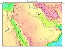
1006:, one of the truly forbidding sand deserts in the world and, until the 1950s, one of the least explored. The topography of this huge area, covering more than 550,000 square kilometers, is varied. In the west, the elevation is about 600 meters, and the sand is fine and soft; in the east, the elevation drops to about 180 meters, and much of the surface is covered by relatively stable sand sheets and salt flats. In places, particularly in the east, longitudinal sand dunes prevail; elsewhere sand mountains as much as 300 meters in height form complex patterns. Most of the area is totally waterless and uninhabited except for the few wandering Bedouin tribes.
657:
992:—sometimes called the Great Nafud because An Nafud is the term for desert—covers about 55,000 square kilometers at an elevation of about 1,000 meters. Longitudinal dunes—scores of kilometers in length and as much as 90 meters high and separated by valleys as much as 16 kilometers wide—characterize the An Nafud. Iron oxide gives the sand a red tint, particularly when the sun is low. Within the area are several watering places, and winter rains bring up short-lived succulent grasses that permit nomadic herding during the winter and spring.
612:
368:. This section of the border with Yemen was demarcated in 1934 and is one of the few clearly defined borders with a neighbouring country. The Saudi border running southeast from Najran, however, is undetermined. The undemarcated border became an issue in the early 1990s, when oil was discovered in the area and Saudi Arabia objected to the commercial exploration by foreign companies on behalf of Yemen. In the summer of 1992, representatives of Saudi Arabia and Yemen met in Geneva to discuss settlement of the border issue.
1581:
428:, and both countries contracted with foreign oil companies to perform exploration work in the Divided Zone. After years of discussions, Saudi Arabia and Kuwait reached an agreement in 1965 that divided the zone geographically, with each country administering its half of the zone. The agreement guaranteed that the rights of both parties to the natural resources in the whole zone would continue to be respected after each country had annexed its half of the zone in 1966.
770:
26:
333:
925:
796:. South of Hejaz, the mountains exceed 2,400 meters in several places with some peaks nearing 3,000 meters. The eastern slope of the mountain range in Asir is gentle, melding into a plateau region that drops gradually into the Rub al Khali. Although rainfall is infrequent in this area, several fertile wadis, of which the most important are the Wadi Bishah and the Wadi Tathlith, make oasis agriculture possible on a relatively large scale.
261:
3087:
641:
1047:
coast that sustained the worst damage, sediments were found to contain 7% oil. The shallow areas affected normally provide feeding grounds for birds, and feeding and nursery areas for fish and shrimp. Because the plants and animals of the sea floor are the basis of the food chain, damage to the shoreline has consequences for the whole shallow-water ecosystem, including the multimillion-dollar Saudi fisheries industry.
649:
341:
272:
3058:
2651:
3068:
2661:
738:, extends east to the Jabal Tuwayq and slightly beyond. A long, narrow strip of desert known as Ad Dahna separates Najd from eastern Arabia, which slopes eastward to the sandy coast along the Persian Gulf. North of Najd a larger desert, An Nafud, isolates the heart of the peninsula from the steppes of northern Arabia. South of Najd lies one of the largest sand deserts in the world, the
957:
near
Dhahran and merges with the Rub al Khali at its southern end. The coast is extremely irregular, merging sandy plains, marshes, and salt flats almost imperceptibly with the sea. As a result, the land surface is unstable; in places water rises almost to the surface, and the sea is shallow, with shoals and reefs extending far offshore. Only the construction of long
758:
632:
encourage
Bedouin settlement, have increased water resource exploitation. In the early 1990s, large-scale agricultural projects have relied primarily on such underground aquifers, which provided more than 80% of the water for agricultural requirements. In fiscal year (FY) 1987, about 90% of the total water demand in the kingdom was consumed by agriculture.
1420:
1396:
981:
940:, a large basin as much as 300 meters below the surrounding plateau, which is the vestige of an ancient inland sea. For thousands of years, some of the heavily traveled caravan routes between the Mediterranean and the central and southern peninsula have passed through the Wadi as Sirhan. The most important oases in the area are Al Jawf and
391:. In 1965, Saudi Arabia and Jordan agreed to boundary demarcations involving an exchange of areas of territory. Jordan gained 19 km (12 mi) of land on the Gulf of Aqaba and 6,000 square kilometers of territory in the interior, and 7,000 square kilometers of Jordanian-administered, landlocked territory was ceded to Saudi Arabia.
999:, a narrow band of sand mountains also called the river of sand. Like the An Nafud, its sand tends to be reddish, particularly in the north, where it shares with the An Nafud the longitudinal structure of sand dunes. The Ad Dahna furnishes the Bedouin with winter and spring pasture, although water is scarcer than in the An Nafud.
1064:
and in rainfall over the southern members of the
Community of Independent States, Iran, Oman, and Turkey. Residents of Riyadh reported that cars and outdoor furniture were covered daily with a coating of oily soot. Samples of soil and vegetation in Ras al Khafji in northern Saudi Arabia revealed high
1055:
because of the seawater cooling system for primary industries and threatened the supply of potable water produced by seawater-fed desalination plants. The 'Al Jubayl community harbor and Abu Ali Island, which juts into the gulf immediately north of 'Al Jubayl, experienced the greatest pollution, with
415:
of both countries. In May 1938, Iraq and Saudi Arabia signed an additional agreement regarding the administration of the zone. Forty-three years later, Saudi Arabia and Iraq signed an agreement that defined the border between the two countries and provided for the division of the neutral zone between
631:
have made separate and joint efforts to exploit underground water resources. In the past, improperly drilled wells have reduced or destroyed any good they might have served by leaching the lands they were drilled to irrigate. Successive agricultural projects, many of which were designed primarily to
1059:
The exploding and burning of approximately 700 oil wells in Kuwait also created staggering levels of atmospheric pollution, spewed oily soot into the surrounding areas, and produced lakes of oil in the
Kuwaiti desert equal in volume to 20 times the amount of oil that poured into the gulf, or about
1046:
of 1991 brought serious environmental damage to the region. The world's largest oil spill, estimated at as much as 8,000,000 barrels (1,300,000 m), fouled gulf waters and the coastal areas of Kuwait, Iran, and much of Saudi Arabia's
Persian Gulf shoreline. In some of the sections of the Saudi
956:
Farther east the terrain changes abruptly to the flat lowlands of the coastal plain. This area, about sixty kilometers wide, is generally featureless and covered with gravel or sand. In the north is the Ad
Dibdibah graveled plain and in the south the 'Al Jafurah sand desert, which reaches the gulf
879:
Across the peninsula as a whole, the plateau slopes toward the east from an elevation of 1,360 meters in the west to 750 meters at its easternmost limit. Wadis cross the region in an eastward direction from the Red Sea escarpment toward the
Persian Gulf. There is little pattern to these remains of
784:
in
Tihamah. The northern range in the Hejaz seldom exceeds 2,100 meters, and the elevation gradually decreases toward the south to about 600 meters. The rugged mountain wall drops abruptly to the sea with only a few intermittent coastal plains. There are virtually no natural harbors along the Red
1056:
the main effect of the spill concentrated in mangrove areas and shrimp grounds. Large numbers of marine birds, such as cormorants, grebes, and auks, were killed when their plumage was coated with oil. In addition, beaches along the entire 'Al Jubayl coastline were covered with oil and tar balls.
1030:. Some have tiny entrances which open into caves, others lead into a maze of passages which can be several kilometers long. Local Bedouin have long known of these caves, and some were used as water supplies. They were first systematically studied in 1981, and later explored and reported by the
936:. It is an upland plateau scored by numerous wadis, most tending northeastward toward Iraq. This area, known as Badiyat ash Sham and covered with grass and scrub vegetation, is extensively used for pasture by nomadic and seminomadic herders. The most significant feature of the area is the
704:. These fault lines are believed to be the northern and final portion of the Great Rift and are presumed to be the result of the slow rotation of the Arabian Peninsula counterclockwise in a way that will, in approximately ten million years, close off the Persian Gulf and make it a lake.
952:
East of the Ad Dahna lies the As Summen
Plateau, about 120 kilometers wide and dropping in elevation from about 400 meters in the west to about 240 meters in the east. The area is generally barren, with a highly eroded surface of ancient river gorges and isolated buttes.
319:
are undefined, so the exact size of the country remains unknown. The Saudi government estimate is at 2,217,949 square kilometres, while other reputable estimates vary between 2,149,690 and 2,240,000 sq. kilometres. Less than 7% of the total area is suitable for
448:
in 1927. In a 1975 agreement with Saudi Arabia, Abu Dhabi accepted sovereignty over six villages in the 'Al
Buraymi Oasis and the sharing of the rich Zararah oil field. In return, Saudi Arabia obtained an outlet to the Persian Gulf through Abu Dhabi.
431:
Saudi Arabia's eastern boundary follows the Persian Gulf from Ras 'al Khafji to the peninsula of Qatar, whose border with Saudi Arabia was determined in 1965. The border with Oman on the southeastern coast of the Arabian Peninsula runs through the
715:. The eastern slope of this escarpment is relatively gentle, dropping to the exposed shield of the ancient landmass that existed before the faulting occurred. A second lower escarpment, the Jabal Tuwayq, runs north to south through the area of
452:
Saudi Arabia's maritime claims include a twelve-nautical-mile (22 km) territorial limit along its coasts. The country also claims many small islands as well as some seabeds and subsoils beyond the twelve-nautical-mile (22 km) limit.
1781:
419:
The boundary between Ibn Saud's territories of Najd and the Eastern Province and the British protectorate of Kuwait was first regulated by the Al Uqair Convention in 1922. In an effort to avoid territorial disputes, another diamond-shaped
1050:
The spill had a severe impact on the coastal area surrounding Madinat 'al-Jubayl as Sinaiyah, the major industrial and population center newly planned and built by the Saudi government. The spill threatened industrial facilities in
594:
numerous large, deep pools are constantly replenished by artesian springs as a result of underground water from the eastern watershed of the Jabal Tuwayq. Such springs and wells permit extensive irrigation in local oases. In the
799:
Extensive lava fields (harrat) scar the surfaces of the plateaus east of the mountain ranges in the Hijaz and give evidence of fairly recent volcanic activity. The largest of these beds is Khaybar, north of Medina; another is
1069:
warned that eating livestock that grazed within an area of 7,000 square kilometers of the fires, or 1,100 kilometers from the center of the fires, an area that included northern Saudi Arabia, posed a danger to human health.
700:. Scientists analyzing photographs taken by United States astronauts on the joint United States-Soviet space mission in July 1975 detected a vast fan-shaped complex of cracks and fault lines extending north and east from the
820:
lowlands, whose width averages 65 kilometers. Along the seacoast is a salty tidal plain of limited agricultural value, backed by potentially rich alluvial plains. The relatively well-watered and fertile upper slopes and the
1073:
To these two major sources of environmental damage must be added large quantities of refuse, toxic materials, and between 173 million and 207 million liters of untreated sewage in sand pits left behind by coalition forces.
785:
Sea. The western slopes have been stripped of soil by the erosion of infrequent, but turbulent rainfalls that have fertilized the plains to the west. The eastern slopes are less steep and are marked by dry river beds (
895:
The heart of Najd is the area of the Jabal Tuwayq, an arc-shaped ridge with a steep west face that rises between 100 and 250 meters above the plateau. Many oases exist in this area, the most important of which are
406:
of approximately 7,000 square kilometers, adjacent to the western tip of Kuwait, within which neither Iraq nor Saudi Arabia would build permanent dwellings or installations. The agreement was designed to safeguard
1089:; depletion of ground water resources; the lack of perennial rivers or permanent water bodies has prompted the development of extensive seawater desalination facilities; coastal pollution from oil spills
607:
and the great deserts, watering places are comparatively fewer and scattered over a wide area. Water must be hoisted or pumped to the surface, and even where water is plentiful its quality may be poor.
324:, and in the early 1960s, population distribution varied greatly among the towns of the eastern and western coastal areas, the densely populated interior oases, and the vast, almost empty deserts.
968:
or 'Al Ahsa after the great oasis, one of the more fertile areas of the country. 'Al-Hasa, the largest oasis in the country, actually comprises two neighbouring oases, including the town of Al-
1899:
571:
formed in prehistoric times and non-renewable. 'Al Kharj was a valuable source of drinking water in a barren terrain. In recent years, these aquifers have been drawn upon heavily, both for
1202:
1099:
398:
and British officials representing Iraqi interests signed the Treaty of Mohammara which established the boundary between Iraq and the future Saudi Arabia. Later that year, the
2041:
988:
Three great deserts isolate the great plateau area Najd of Saudi Arabia from the north, east, and south, as the Red Sea escarpment does from the west. In the north, the
2026:
2616:
3023:
1496:
792:
Scattered oases, drawing water from springs and wells in the vicinity of the wadis, permit some agriculture. Of these oases, the largest and most important is
676:. Geologic movements caused the entire mass to tilt eastward and the western and southern edges to tilt upward. In the valley created by the fault, called the
1134:
2,250,000 km² (international borders of Saudi Arabia are not finalized. Saudi government claim large tracts of land inside the neighboring countries of
2290:
2085:
1914:
546:
2243:
1509:
93:
848:. This region is mainly rocky plateau interspersed by small, sandy deserts and isolated mountain clumps. The best known of the mountain groups is the
2626:
1946:
1706:
1606:
2972:
2565:
1894:
627:, the largest aquifer in Saudi Arabia, contains more water than the Persian Gulf. The Saudi government, Saudi Aramco, and the United Nations (UN)
421:
3033:
2540:
1681:
403:
2697:
1676:
1621:
1066:
830:
2947:
2585:
1833:
1749:
1616:
58:
3108:
1956:
1739:
1217:
1146:
in addition to others. The present figure for the size of that states includes all those territories that are outside Saudi control)
2992:
2053:
1889:
1691:
1686:
1626:
1489:
1463:
1256:
1222:
1002:
The southern portion of the Ad Dahna curves westward following the arc of the Jabal Tuwayq. At its southern end, it merges with the
628:
209:
1769:
2189:
2078:
1987:
1601:
246:
Desertification; depletion of ground water; lack of perennial rivers or permanent water bodies; coastal pollution from oil spills
2283:
2197:
2145:
1921:
1853:
1711:
1207:
2375:
1971:
1716:
1570:
1337:
Murray, N.J.; Phinn, S.R.; DeWitt, M.; Ferrari, R.; Johnston, R.; Lyons, M.B.; Clinton, N.; Thau, D.; Fuller, R.A. (2019).
2621:
1843:
1636:
1263:
619:
Modern technology has located and increased the availability of much of the underground water. Saudi Arabian Oil Company (
1212:
2782:
2580:
2485:
2068:
2014:
1909:
1858:
1838:
1754:
1726:
1482:
1468:
3028:
2108:
2048:
1884:
1791:
1759:
1565:
572:
321:
228:
224:
424:
of 5,790 square kilometers directly south of Kuwait was established. In 1938 oil was discovered in Kuwait's southern
623:) technicians have determined that very deep aquifers lie in many areas of northern and eastern Arabia and that the
444:(one of the emirates of the UAE) and Saudi Arabia, has triggered extensive dispute among the three states since the
2987:
2892:
2590:
2276:
2133:
2004:
1926:
680:, the Red Sea was formed. The Great Rift runs from the Mediterranean along both sides of the Red Sea south through
542:
1268:
1014:
Beneath the harsh deserts of Saudi Arabia lie dark chambers and complex mazes filled with crystalline structures,
656:
2535:
2455:
2073:
2036:
2031:
1966:
1776:
1744:
1734:
1631:
1411:
2997:
2714:
2690:
2425:
2420:
2315:
2307:
2179:
2167:
2150:
2063:
1999:
1848:
1805:
1655:
1641:
440:
and water rights. The border through 'Al Buraymi Oasis, located near the conjunction of the frontiers of Oman,
2942:
2907:
2862:
2545:
2520:
2435:
2415:
2365:
2335:
2325:
2236:
2174:
2095:
2058:
1961:
1872:
1828:
1611:
1517:
1031:
801:
528:
445:
436:(Rub 'al-Khali). The border demarcation was defined by a 1990 agreement that included provisions for shared
265:
1424:
780:
The western coastal escarpment can be considered two mountain ranges separated by a gap in the vicinity of
2832:
2827:
2722:
2631:
2510:
2505:
2385:
2207:
2113:
1904:
1580:
1119:
399:
383:. The northern boundary extends almost 1,400 km (870 mi) from the Gulf of Aqaba on the west to
2952:
2927:
2842:
2822:
2772:
2742:
2732:
2575:
2525:
2480:
2460:
2450:
2350:
2252:
2162:
2155:
2140:
2128:
2118:
2019:
2009:
1823:
789:) that trace the courses of ancient rivers and continue to lead the rare rainfalls down to the plains.
707:
On the peninsula, the eastern line of the Great Rift fault is visible in the steep and, in places, high
1449:
1060:
150,000,000 barrels (24,000,000 m). The soot from the Kuwaiti fires was found in the snows of the
611:
3038:
2917:
2912:
2792:
2550:
2465:
2445:
2330:
2320:
2212:
1764:
1696:
826:
582:
seawater and very scarce surface water must supply the country's needs. In eastern Arabia and in the
488:
308:
3092:
3012:
2982:
2932:
2887:
2867:
2857:
2757:
2683:
2605:
2595:
2530:
2495:
2430:
2410:
2400:
2360:
2345:
2340:
2257:
1273:
958:
360:
form a coastal border of almost 1,800 km (1,100 mi) that extends to the southern part of
220:
3067:
2660:
25:
2957:
2872:
2852:
2737:
2727:
2636:
2555:
2515:
2490:
2470:
2405:
2380:
2370:
2355:
1941:
1813:
1671:
1550:
1535:
1530:
1525:
1366:
1107:
560:
332:
769:
307:. The kingdom occupies 80% of the Arabian Peninsula. Most of the country's boundaries with the
3002:
2937:
2902:
2837:
2817:
2807:
2767:
2752:
2747:
2475:
2440:
2395:
2390:
2299:
2103:
1545:
1540:
1459:
1358:
1294:
1249:
1227:
849:
805:
677:
665:
316:
288:
672:
composed of stable crystalline rock whose geologic structure developed concurrently with the
3043:
2962:
2922:
2897:
2877:
2812:
2787:
2777:
2762:
1818:
1560:
1350:
1242:
1111:
1003:
924:
364:
and follows a mountain ridge for approximately 320 km (200 mi) to the vicinity of
624:
260:
2882:
2847:
2802:
2797:
2706:
1555:
1295:"International Boundary Study, No. 60 – December 30, 1965, Jordan – Saudi Arabia Boundary"
1237:
1103:
1086:
996:
889:
865:
660:
Köppen–Geiger climate classification map at 1-km resolution for Saudi Arabia (1991–2020)
640:
1786:
1232:
1115:
885:
822:
773:
600:
437:
352:
Saudi Arabia is bounded by seven countries and three bodies of water. To the west, the
205:
172:
648:
3102:
3061:
2654:
1400:
965:
933:
869:
701:
591:
587:
512:
433:
353:
184:
1370:
1338:
873:
1505:
995:
Stretching more than 125 kilometers south from the An Nafud in a narrow arc is the
857:
739:
712:
620:
583:
579:
556:
425:
388:
345:
340:
292:
280:
271:
156:
1026:
area to the east of the Dahna sands, is riddled with such caves, known locally as
816:
The rugged western face of the escarpment drops steeply to the coastal plain, the
3071:
2664:
1936:
937:
881:
872:
in the late 19th and early 20th centuries. Their capital was the large oasis of
749:
in Saudi Arabia, making it the 37th ranked country in terms of tidal flat area.
685:
578:
In the absence of permanent rivers or bodies of water, streams and groundwater,
550:
408:
344:
Image showing the approximate land exchanged between Jordan (gaining green) and
143:
3082:
1354:
1323:
1019:
1015:
708:
689:
304:
73:
60:
1061:
833:
745:
A recent global remote sensing analysis suggested that there were 706km² of
441:
300:
284:
46:
1362:
1065:
levels of particles of oily soot incorporated into the desert ecology. The
912:. Outside the oasis areas, Najd is sparsely populated. Large salt marshes (
1429:
961:
at Ras Tanura has opened the Saudi coast on the gulf to seagoing tankers.
757:
299:. Its extensive coastlines provide great leverage on shipping (especially
1701:
1405:
1043:
989:
909:
897:
697:
681:
564:
395:
1474:
575:
and domestic purposes, and no fresh water remains in the lakes or pits.
2217:
1951:
941:
901:
861:
817:
746:
723:
568:
412:
357:
296:
160:
980:
2123:
1382:
1380:
1143:
1052:
913:
905:
853:
793:
762:
716:
693:
669:
476:
472:
402:
signed by the two parties agreed to the creation of a diamond-shaped
384:
380:
372:
365:
2268:
615:
Saudi Arabia is the third most water stressed country in the world.
2675:
2202:
1135:
1023:
979:
969:
923:
781:
768:
756:
731:
727:
655:
647:
639:
610:
596:
492:
484:
361:
339:
331:
270:
259:
1399:
This article incorporates text from this source, which is in the
836:. Both Mecca and Jeddah lie within the northern part of Tihamah.
1931:
1139:
845:
786:
735:
673:
604:
480:
468:
376:
312:
36:
2679:
2272:
1478:
1435:
1318:
196:
Most of Saudi Arabia follows a desert climate, with exceptions
932:
The area north of the An Nafud is geographically part of the
829:
to allow maximum land use. This coastal plain is part of the
711:
that parallels the Red Sea between the Gulf of Aqaba and the
416:
them. The agreement effectively dissolved this neutral zone.
844:
East of the Hejaz and Asir lies the great plateau area of
1339:"The global distribution and trajectory of tidal flats"
1324:
World Food and Agriculture – Statistical Yearbook 2023
599:, wells are abundant, and springs are common in the
336:
Topography of Saudi Arabia and surrounding countries
3011:
2971:
2713:
2604:
2564:
2306:
2188:
2094:
1986:
1871:
1804:
1725:
1654:
1588:
1516:
250:
242:
234:
216:
200:
192:
180:
168:
152:
139:
131:
123:
115:
107:
99:
89:
52:
42:
32:
1203:Saudi Arabia – United Arab Emirates border dispute
880:ancient riverbeds; the most important of them are
1386:Yaqut al-Hamawi, Mu'jam Al-Buldan, vol. 2, p. 219
726:, rises gradually from the sea to the mountains.
644:Topography of Saudi Arabia (Altitude color coded)
730:extends southward to the borders of mountainous
1022:. The limestone floor of the Summan plateau, a
2691:
2284:
1490:
1471:at Arabian Plate Sequence Stratigraphy, 2004.
8:
928:arean with shallow lakes in the Qasim region
18:
1900:Council of Economic and Development Affairs
547:Water supply and sanitation in Saudi Arabia
103:2,149,690 km (830,000 sq mi)
2698:
2684:
2676:
2291:
2277:
2269:
1992:
1877:
1664:
1660:
1594:
1497:
1483:
1475:
864:tribes, which under the leadership of the
17:
533:228,633 km (88,276 sq mi)
525:12 nmi (22.2 km; 13.8 mi)
371:To the north, Saudi Arabia is bounded by
860:. This area is the home of the pastoral
688:, gradually disappearing in the area of
254:228,633 km (88,276 sq mi)
1286:
1093:Environment - international agreements:
916:) are scattered throughout the area.
868:were the most implacable foes of the
264:Detailed map of Saudi Arabia and its
7:
1067:United Nations Environment Programme
831:Arabian Peninsula coastal fog desert
135:Total: 4,415 km (2,743 mi)
964:Eastern Arabia is sometimes called
804:, part of the large volcanic field
722:In the south, a coastal plain, the
303:) through the Persian Gulf and the
1218:Mountains in the Arabian Peninsula
876:, now a flourishing urban center.
14:
1687:Custodian of the Two Holy Mosques
1257:List of volcanoes in Saudi Arabia
1223:List of mountains in Saudi Arabia
984:Highway crossing the Nafud desert
629:Food and Agriculture Organization
3085:
3066:
3057:
3056:
2659:
2650:
2649:
1579:
1423: This article incorporates
1418:
1394:
404:Saudi Arabian–Iraqi neutral zone
24:
1854:General Intelligence Presidency
3024:British Indian Ocean Territory
2617:British Indian Ocean Territory
1080:frequent sand and dust storms
944:, just north of the An Nafud.
652:Saudi Arabia physical features
636:Topography and natural regions
590:and springs are plentiful. In
1:
1844:Chairman of the General Staff
1407:Saudi Arabia: A Country Study
1264:List of wadis of Saudi Arabia
1084:Environment - current issues:
515:(33.3 km; 20.7 mi)
287:, the largest country on the
188:20,000 ha (49,421 acres)
127:2,640 km (1,640 mi)
148:3,015 m (9,892 ft)
2086:Water supply and sanitation
1915:History of the oil industry
1782:Mutaween (religious police)
3125:
1450:Saudi Arabia - The Geology
1208:Saudi–Kuwaiti neutral zone
567:, fed by huge underground
543:Irrigation in Saudi Arabia
540:
422:Saudi–Kuwaiti neutral zone
3109:Geography of Saudi Arabia
3052:
2645:
2230:
1995:
1880:
1707:National Security Council
1667:
1663:
1597:
1577:
1412:Federal Research Division
1355:10.1038/s41586-018-0805-8
765:escarpment from the west.
283:is a country situated in
176:600 km (373 mi)
23:
19:Geography of Saudi Arabia
2773:East Timor (Timor-Leste)
2366:East Timor (Timor-Leste)
1952:Tadawul (stock exchange)
1947:Supreme Economic Council
1895:Capital Market Authority
1849:General Staff Presidency
1702:Mabahith (secret police)
1300:. US Department of State
1213:Saudi–Iraqi neutral zone
684:and the lake country of
563:and deep waterholes at '
275:Location of Saudi Arabia
3034:Cocos (Keeling) Islands
2627:Cocos (Keeling) Islands
1834:Strategic Missile Force
1032:Saudi Geological Survey
825:behind are extensively
734:. The central plateau,
529:exclusive economic zone
251:Exclusive economic zone
1425:public domain material
1120:Ozone Layer Protection
1038:Environmental concerns
985:
929:
856:and just south of the
777:
766:
661:
653:
645:
616:
349:
337:
276:
268:
1682:Consultative Assembly
1327:. Rome. p. 41–42
1269:Sykes–Picot Agreement
1179:Forests and Woodland:
983:
927:
772:
760:
659:
651:
643:
614:
343:
335:
274:
263:
2948:United Arab Emirates
2541:United Arab Emirates
888:, Wadi as Surr, and
309:United Arab Emirates
243:Environmental issues
164:0 m (0 ft)
3093:Saudi Arabia portal
2975:limited recognition
2568:limited recognition
1942:Saudi Central Bank
1750:Freedom of religion
1531:Early Islamic State
1174:Permanent pastures:
1151:2,250,000 km²
70: /
20:
1957:Telecommunications
1740:Capital punishment
1672:Allegiance Council
1551:Emirate of Diriyah
1536:Rashidun Caliphate
1526:Pre-Islamic Arabia
1431:The World Factbook
1108:Endangered Species
986:
930:
778:
767:
662:
654:
646:
617:
518:continental shelf:
350:
338:
277:
269:
227:, fish, minerals,
116: • Water
100: • Total
3080:
3079:
3017:other territories
2673:
2672:
2610:other territories
2300:Geography of Asia
2266:
2265:
2226:
2225:
2054:Human trafficking
1982:
1981:
1867:
1866:
1800:
1799:
1692:Foreign relations
1650:
1649:
1546:Abbasid Caliphate
1541:Umayyad Caliphate
1469:Geological Charts
1456:Origins of Arabia
1454:Andrew Thompson,
1349:(7738): 222–225.
1250:Shammar Mountains
806:Harrat Ash Shamah
666:Arabian Peninsula
601:mountainous areas
555:Until the 1980s,
466:border countries:
317:Republic of Yemen
289:Arabian Peninsula
258:
257:
238:Haze, dust storms
217:Natural resources
210:mountainous areas
108: • Land
74:25.000°N 45.000°E
3116:
3095:
3090:
3089:
3088:
3070:
3060:
3059:
3029:Christmas Island
2715:Sovereign states
2707:Climate of Asia
2700:
2693:
2686:
2677:
2663:
2653:
2652:
2622:Christmas Island
2308:Sovereign states
2293:
2286:
2279:
2270:
2246:
2239:
2079:response to ISIL
1993:
1937:Riyal (currency)
1878:
1665:
1661:
1607:Cities and towns
1595:
1583:
1561:Kingdom of Hejaz
1499:
1492:
1485:
1476:
1439:
1422:
1421:
1415:
1398:
1397:
1387:
1384:
1375:
1374:
1334:
1328:
1316:
1310:
1309:
1307:
1305:
1299:
1291:
1274:Winston's Hiccup
1243:Midian Mountains
1169:Permanent crops:
1112:Hazardous Wastes
1078:Natural hazards:
523:territorial sea:
509:contiguous zone:
505:Maritime claims:
457:Land boundaries:
446:Treaty of Jeddah
411:in the zone for
291:, bordering the
85:
84:
82:
81:
80:
75:
71:
68:
67:
66:
63:
28:
21:
3124:
3123:
3119:
3118:
3117:
3115:
3114:
3113:
3099:
3098:
3091:
3086:
3084:
3081:
3076:
3048:
3016:
3007:
2988:Northern Cyprus
2974:
2967:
2709:
2704:
2674:
2669:
2641:
2609:
2600:
2581:Northern Cyprus
2567:
2560:
2302:
2297:
2267:
2262:
2249:
2242:
2235:
2222:
2184:
2146:Public holidays
2090:
1978:
1922:Foreign workers
1863:
1796:
1721:
1712:Nuclear program
1646:
1584:
1575:
1556:Emirate of Nejd
1512:
1503:
1446:
1444:Further reading
1428:
1419:
1404:
1395:
1391:
1390:
1385:
1378:
1336:
1335:
1331:
1317:
1313:
1303:
1301:
1297:
1293:
1292:
1288:
1283:
1278:
1238:Hijaz Mountains
1228:Sarat Mountains
1198:
1192:4,350 km²
1190:Irrigated land:
1182:
1177:
1172:
1167:
1162:
1152:
1147:
1127:
1104:Desertification
1095:
1087:desertification
1040:
1012:
997:Ad-Dahna Desert
978:
950:
922:
920:Northern Arabia
890:Wadi ad-Dawasir
852:, northwest of
842:
814:
776:volcanic field.
755:
638:
553:
539:
537:Water resources
526:
521:
516:
507:
464:
459:
330:
279:The Kingdom of
235:Natural hazards
187:
175:
163:
147:
78:
76:
72:
69:
64:
61:
59:
57:
56:
12:
11:
5:
3122:
3120:
3112:
3111:
3101:
3100:
3097:
3096:
3078:
3077:
3075:
3074:
3064:
3053:
3050:
3049:
3047:
3046:
3041:
3036:
3031:
3026:
3020:
3018:
3009:
3008:
3006:
3005:
3000:
2995:
2990:
2985:
2979:
2977:
2969:
2968:
2966:
2965:
2960:
2955:
2950:
2945:
2940:
2935:
2930:
2925:
2920:
2915:
2910:
2905:
2900:
2895:
2890:
2885:
2880:
2875:
2870:
2865:
2860:
2855:
2850:
2845:
2840:
2835:
2830:
2825:
2820:
2815:
2810:
2805:
2800:
2795:
2790:
2785:
2780:
2775:
2770:
2765:
2760:
2755:
2750:
2745:
2740:
2735:
2730:
2725:
2719:
2717:
2711:
2710:
2705:
2703:
2702:
2695:
2688:
2680:
2671:
2670:
2668:
2667:
2657:
2646:
2643:
2642:
2640:
2639:
2634:
2629:
2624:
2619:
2613:
2611:
2602:
2601:
2599:
2598:
2593:
2588:
2583:
2578:
2572:
2570:
2562:
2561:
2559:
2558:
2553:
2548:
2543:
2538:
2533:
2528:
2523:
2518:
2513:
2508:
2503:
2498:
2493:
2488:
2483:
2478:
2473:
2468:
2463:
2458:
2453:
2448:
2443:
2438:
2433:
2428:
2423:
2418:
2413:
2408:
2403:
2398:
2393:
2388:
2383:
2378:
2373:
2368:
2363:
2358:
2353:
2348:
2343:
2338:
2333:
2328:
2323:
2318:
2312:
2310:
2304:
2303:
2298:
2296:
2295:
2288:
2281:
2273:
2264:
2263:
2261:
2260:
2255:
2248:
2247:
2240:
2232:
2231:
2228:
2227:
2224:
2223:
2221:
2220:
2215:
2210:
2205:
2200:
2194:
2192:
2186:
2185:
2183:
2182:
2177:
2172:
2171:
2170:
2160:
2159:
2158:
2148:
2143:
2138:
2137:
2136:
2126:
2121:
2116:
2111:
2106:
2100:
2098:
2092:
2091:
2089:
2088:
2083:
2082:
2081:
2071:
2066:
2061:
2056:
2051:
2046:
2045:
2044:
2039:
2029:
2027:Discrimination
2024:
2023:
2022:
2012:
2007:
2002:
1996:
1990:
1984:
1983:
1980:
1979:
1977:
1976:
1975:
1974:
1964:
1959:
1954:
1949:
1944:
1939:
1934:
1929:
1924:
1919:
1918:
1917:
1912:
1902:
1897:
1892:
1887:
1881:
1875:
1869:
1868:
1865:
1864:
1862:
1861:
1859:Military ranks
1856:
1851:
1846:
1841:
1839:National Guard
1836:
1831:
1826:
1821:
1816:
1810:
1808:
1802:
1801:
1798:
1797:
1795:
1794:
1789:
1784:
1779:
1774:
1773:
1772:
1767:
1762:
1752:
1747:
1742:
1737:
1731:
1729:
1723:
1722:
1720:
1719:
1717:Prime Minister
1714:
1709:
1704:
1699:
1694:
1689:
1684:
1679:
1674:
1668:
1658:
1652:
1651:
1648:
1647:
1645:
1644:
1639:
1634:
1629:
1624:
1619:
1614:
1609:
1604:
1598:
1592:
1586:
1585:
1578:
1576:
1574:
1573:
1571:Modern history
1568:
1563:
1558:
1553:
1548:
1543:
1538:
1533:
1528:
1522:
1520:
1514:
1513:
1504:
1502:
1501:
1494:
1487:
1479:
1473:
1472:
1466:
1452:
1445:
1442:
1441:
1440:
1416:
1389:
1388:
1376:
1329:
1311:
1285:
1284:
1282:
1279:
1277:
1276:
1271:
1266:
1261:
1260:
1259:
1254:
1253:
1252:
1247:
1246:
1245:
1240:
1235:
1233:Asir Mountains
1215:
1210:
1205:
1199:
1197:
1194:
1126:
1123:
1116:Law of the Sea
1100:Climate Change
1039:
1036:
1011:
1008:
977:
974:
949:
948:Eastern Arabia
946:
938:Wadi as Sirhan
921:
918:
886:Wadi ar Rummah
841:
838:
813:
810:
774:Harrat al Birk
761:A view of the
754:
751:
668:is an ancient
637:
634:
588:artesian wells
538:
535:
520:not specified
501:2,640 km
495:1,458 km
463:4,415 km
438:grazing rights
400:Uqair Protocol
329:
326:
256:
255:
252:
248:
247:
244:
240:
239:
236:
232:
231:
218:
214:
213:
206:desert covered
202:
198:
197:
194:
190:
189:
182:
178:
177:
173:Wadi al-Rummah
170:
166:
165:
154:
150:
149:
141:
137:
136:
133:
129:
128:
125:
121:
120:
117:
113:
112:
109:
105:
104:
101:
97:
96:
91:
87:
86:
79:25.000; 45.000
54:
50:
49:
44:
40:
39:
34:
30:
29:
13:
10:
9:
6:
4:
3:
2:
3121:
3110:
3107:
3106:
3104:
3094:
3083:
3073:
3069:
3065:
3063:
3055:
3054:
3051:
3045:
3042:
3040:
3037:
3035:
3032:
3030:
3027:
3025:
3022:
3021:
3019:
3014:
3010:
3004:
3001:
2999:
2998:South Ossetia
2996:
2994:
2991:
2989:
2986:
2984:
2981:
2980:
2978:
2976:
2970:
2964:
2961:
2959:
2956:
2954:
2951:
2949:
2946:
2944:
2941:
2939:
2936:
2934:
2931:
2929:
2926:
2924:
2921:
2919:
2916:
2914:
2911:
2909:
2906:
2904:
2901:
2899:
2896:
2894:
2891:
2889:
2886:
2884:
2881:
2879:
2876:
2874:
2871:
2869:
2866:
2864:
2861:
2859:
2856:
2854:
2851:
2849:
2846:
2844:
2841:
2839:
2836:
2834:
2831:
2829:
2826:
2824:
2821:
2819:
2816:
2814:
2811:
2809:
2806:
2804:
2801:
2799:
2796:
2794:
2791:
2789:
2786:
2784:
2781:
2779:
2776:
2774:
2771:
2769:
2766:
2764:
2761:
2759:
2756:
2754:
2751:
2749:
2746:
2744:
2741:
2739:
2736:
2734:
2731:
2729:
2726:
2724:
2721:
2720:
2718:
2716:
2712:
2708:
2701:
2696:
2694:
2689:
2687:
2682:
2681:
2678:
2666:
2662:
2658:
2656:
2648:
2647:
2644:
2638:
2635:
2633:
2630:
2628:
2625:
2623:
2620:
2618:
2615:
2614:
2612:
2607:
2603:
2597:
2594:
2592:
2591:South Ossetia
2589:
2587:
2584:
2582:
2579:
2577:
2574:
2573:
2571:
2569:
2563:
2557:
2554:
2552:
2549:
2547:
2544:
2542:
2539:
2537:
2534:
2532:
2529:
2527:
2524:
2522:
2519:
2517:
2514:
2512:
2509:
2507:
2504:
2502:
2499:
2497:
2494:
2492:
2489:
2487:
2484:
2482:
2479:
2477:
2474:
2472:
2469:
2467:
2464:
2462:
2459:
2457:
2454:
2452:
2449:
2447:
2444:
2442:
2439:
2437:
2434:
2432:
2429:
2427:
2424:
2422:
2419:
2417:
2414:
2412:
2409:
2407:
2404:
2402:
2399:
2397:
2394:
2392:
2389:
2387:
2384:
2382:
2379:
2377:
2374:
2372:
2369:
2367:
2364:
2362:
2359:
2357:
2354:
2352:
2349:
2347:
2344:
2342:
2339:
2337:
2334:
2332:
2329:
2327:
2324:
2322:
2319:
2317:
2314:
2313:
2311:
2309:
2305:
2301:
2294:
2289:
2287:
2282:
2280:
2275:
2274:
2271:
2259:
2256:
2254:
2251:
2250:
2245:
2241:
2238:
2234:
2233:
2229:
2219:
2216:
2214:
2211:
2209:
2206:
2204:
2201:
2199:
2196:
2195:
2193:
2191:
2187:
2181:
2178:
2176:
2173:
2169:
2166:
2165:
2164:
2161:
2157:
2154:
2153:
2152:
2149:
2147:
2144:
2142:
2139:
2135:
2132:
2131:
2130:
2127:
2125:
2122:
2120:
2117:
2115:
2112:
2110:
2107:
2105:
2102:
2101:
2099:
2097:
2093:
2087:
2084:
2080:
2077:
2076:
2075:
2072:
2070:
2067:
2065:
2062:
2060:
2057:
2055:
2052:
2050:
2047:
2043:
2040:
2038:
2035:
2034:
2033:
2030:
2028:
2025:
2021:
2018:
2017:
2016:
2013:
2011:
2008:
2006:
2003:
2001:
1998:
1997:
1994:
1991:
1989:
1985:
1973:
1970:
1969:
1968:
1965:
1963:
1960:
1958:
1955:
1953:
1950:
1948:
1945:
1943:
1940:
1938:
1935:
1933:
1930:
1928:
1925:
1923:
1920:
1916:
1913:
1911:
1908:
1907:
1906:
1903:
1901:
1898:
1896:
1893:
1891:
1888:
1886:
1883:
1882:
1879:
1876:
1874:
1870:
1860:
1857:
1855:
1852:
1850:
1847:
1845:
1842:
1840:
1837:
1835:
1832:
1830:
1827:
1825:
1822:
1820:
1817:
1815:
1812:
1811:
1809:
1807:
1803:
1793:
1790:
1788:
1785:
1783:
1780:
1778:
1775:
1771:
1768:
1766:
1763:
1761:
1758:
1757:
1756:
1753:
1751:
1748:
1746:
1743:
1741:
1738:
1736:
1733:
1732:
1730:
1728:
1724:
1718:
1715:
1713:
1710:
1708:
1705:
1703:
1700:
1698:
1695:
1693:
1690:
1688:
1685:
1683:
1680:
1678:
1675:
1673:
1670:
1669:
1666:
1662:
1659:
1657:
1653:
1643:
1640:
1638:
1635:
1633:
1630:
1628:
1625:
1623:
1620:
1618:
1615:
1613:
1610:
1608:
1605:
1603:
1600:
1599:
1596:
1593:
1591:
1587:
1582:
1572:
1569:
1567:
1564:
1562:
1559:
1557:
1554:
1552:
1549:
1547:
1544:
1542:
1539:
1537:
1534:
1532:
1529:
1527:
1524:
1523:
1521:
1519:
1515:
1511:
1507:
1500:
1495:
1493:
1488:
1486:
1481:
1480:
1477:
1470:
1467:
1465:
1464:1-900988-04-6
1461:
1457:
1453:
1451:
1448:
1447:
1443:
1437:
1433:
1432:
1426:
1417:
1413:
1409:
1408:
1402:
1401:public domain
1393:
1392:
1383:
1381:
1377:
1372:
1368:
1364:
1360:
1356:
1352:
1348:
1344:
1340:
1333:
1330:
1326:
1325:
1321:. 2023.
1320:
1315:
1312:
1296:
1290:
1287:
1280:
1275:
1272:
1270:
1267:
1265:
1262:
1258:
1255:
1251:
1248:
1244:
1241:
1239:
1236:
1234:
1231:
1230:
1229:
1226:
1225:
1224:
1221:
1220:
1219:
1216:
1214:
1211:
1209:
1206:
1204:
1201:
1200:
1195:
1193:
1191:
1187:
1185:
1180:
1175:
1170:
1165:
1161:
1157:
1155:
1150:
1145:
1141:
1137:
1132:
1131:
1124:
1122:
1121:
1117:
1113:
1109:
1105:
1101:
1098:
1094:
1090:
1088:
1085:
1081:
1079:
1075:
1071:
1068:
1063:
1057:
1054:
1048:
1045:
1037:
1035:
1033:
1029:
1025:
1021:
1017:
1009:
1007:
1005:
1004:Rub' al Khali
1000:
998:
993:
991:
982:
976:Great deserts
975:
973:
971:
967:
962:
960:
954:
947:
945:
943:
939:
935:
934:Syrian Desert
926:
919:
917:
915:
911:
907:
903:
899:
893:
891:
887:
883:
877:
875:
871:
867:
863:
859:
855:
851:
850:Jabal Shammar
847:
839:
837:
835:
832:
828:
824:
819:
811:
809:
807:
803:
797:
795:
790:
788:
783:
775:
771:
764:
759:
752:
750:
748:
743:
741:
737:
733:
729:
725:
720:
718:
714:
710:
705:
703:
702:Golan Heights
699:
695:
691:
687:
683:
679:
675:
671:
667:
658:
650:
642:
635:
633:
630:
626:
622:
613:
609:
606:
602:
598:
593:
589:
585:
581:
576:
574:
570:
566:
562:
559:had lakes at
558:
552:
548:
544:
536:
534:
532:
530:
524:
519:
514:
510:
506:
502:
500:
496:
494:
491:457 km,
490:
486:
483:676 km,
482:
479:222 km,
478:
475:728 km,
474:
471:814 km,
470:
467:
462:
458:
454:
450:
447:
443:
439:
435:
434:Empty Quarter
429:
427:
426:Burqan fields
423:
417:
414:
410:
405:
401:
397:
392:
390:
386:
385:Ras al Khafji
382:
378:
374:
369:
367:
363:
359:
355:
354:Gulf of Aqaba
348:(gaining red)
347:
342:
334:
327:
325:
323:
318:
314:
310:
306:
302:
298:
294:
290:
286:
282:
273:
267:
262:
253:
249:
245:
241:
237:
233:
230:
226:
222:
219:
215:
211:
207:
203:
199:
195:
191:
186:
185:Al-Asfar Lake
183:
179:
174:
171:
169:Longest river
167:
162:
158:
155:
151:
145:
142:
140:Highest point
138:
134:
130:
126:
122:
118:
114:
110:
106:
102:
98:
95:
92:
88:
83:
55:
51:
48:
45:
41:
38:
35:
31:
27:
22:
16:
3013:Dependencies
2943:Turkmenistan
2908:Saudi Arabia
2606:Dependencies
2536:Turkmenistan
2501:Saudi Arabia
2500:
2069:Prostitution
2042:universities
2015:Demographics
1910:Oil reserves
1755:Human rights
1622:Governorates
1589:
1506:Saudi Arabia
1455:
1430:
1406:
1346:
1342:
1332:
1322:
1314:
1302:. Retrieved
1289:
1189:
1188:
1183:
1178:
1173:
1168:
1164:Arable land:
1163:
1159:
1158:
1153:
1148:
1133:
1129:
1128:
1096:
1092:
1091:
1083:
1082:
1077:
1076:
1072:
1058:
1049:
1042:The Persian
1041:
1027:
1013:
1001:
994:
987:
963:
955:
951:
931:
894:
878:
843:
815:
798:
791:
779:
744:
740:Rub al Khali
721:
713:Gulf of Aden
706:
663:
621:Saudi Aramco
618:
584:Jabal Tuwayq
577:
573:agricultural
557:Saudi Arabia
554:
527:
522:
517:
508:
504:
503:
498:
497:
487:60 km,
465:
460:
456:
455:
451:
430:
418:
409:water rights
393:
389:Persian Gulf
370:
351:
346:Saudi Arabia
293:Persian Gulf
281:Saudi Arabia
278:
181:Largest lake
157:Persian Gulf
153:Lowest point
15:
3072:Asia portal
2973:States with
2893:Philippines
2833:South Korea
2828:North Korea
2723:Afghanistan
2665:Asia portal
2566:States with
2486:Philippines
2426:South Korea
2421:North Korea
2316:Afghanistan
2109:Visual arts
2049:Health care
1885:Agriculture
1829:Air Defense
1792:Visa policy
1617:Earthquakes
1566:Unification
1156:0 km²
1020:stalagmites
1016:stalactites
882:Wadi Hanifa
747:tidal flats
686:East Africa
580:desalinated
561:Layla Aflaj
551:Zamzam Well
322:cultivation
225:natural gas
144:Jabal Sawda
94:Ranked 12th
77: /
53:Coordinates
2953:Uzbekistan
2928:Tajikistan
2843:Kyrgyzstan
2823:Kazakhstan
2743:Bangladesh
2733:Azerbaijan
2546:Uzbekistan
2521:Tajikistan
2436:Kyrgyzstan
2416:Kazakhstan
2336:Bangladesh
2326:Azerbaijan
2134:television
2005:Censorship
1927:Irrigation
1304:30 January
1281:References
1125:Statistics
1053:'Al Jubayl
709:escarpment
690:Mozambique
678:Great Rift
541:See also:
499:Coastline:
328:Boundaries
315:, and the
305:Suez Canal
212:and plains
3039:Hong Kong
2993:Palestine
2918:Sri Lanka
2913:Singapore
2793:Indonesia
2632:Hong Kong
2586:Palestine
2511:Sri Lanka
2506:Singapore
2386:Indonesia
2074:Terrorism
2037:libraries
2032:Education
1967:Transport
1890:Companies
1824:Air Force
1777:Judiciary
1745:Elections
1735:Basic Law
1632:Provinces
1627:Mountains
1590:Geography
1160:Land use:
1097:party to:
1062:Himalayas
866:Al Rashid
834:ecoregion
823:mountains
802:Al Harrah
442:Abu Dhabi
394:In 1922,
301:crude oil
285:West Asia
221:Petroleum
124:Coastline
47:West Asia
33:Continent
3103:Category
3062:Category
2983:Abkhazia
2933:Thailand
2888:Pakistan
2868:Mongolia
2863:Maldives
2858:Malaysia
2758:Cambodia
2655:Category
2576:Abkhazia
2526:Thailand
2481:Pakistan
2461:Mongolia
2456:Maldives
2451:Malaysia
2351:Cambodia
2253:Category
2180:Heritage
2168:football
2151:Religion
2124:Language
2064:Polygamy
2000:Abortion
1806:Military
1787:Passport
1656:Politics
1642:Wildlife
1510:articles
1458:, 2000,
1371:56481043
1363:30568300
1196:See also
1044:Gulf War
990:An Nafud
966:'Al-Hasa
910:Al Kharj
898:Buraydah
858:An Nafud
827:terraced
698:Zimbabwe
682:Ethiopia
569:aquifers
565:Al-Kharj
511:18
396:Ibn Saud
356:and the
295:and the
2958:Vietnam
2873:Myanmar
2853:Lebanon
2783:Georgia
2738:Bahrain
2728:Armenia
2551:Vietnam
2466:Myanmar
2446:Lebanon
2376:Georgia
2331:Bahrain
2321:Armenia
2237:Outline
2190:Symbols
2175:Theatre
2119:Cuisine
2096:Culture
2059:Obesity
1988:Society
1962:Tourism
1873:Economy
1677:Cabinet
1612:Climate
1602:Borders
1518:History
942:Sakakah
902:Unayzah
870:Al Saud
862:Shammar
818:Tihamah
812:Tihamah
724:Tihamah
592:al-Ahsa
413:Bedouin
387:on the
358:Red Sea
311:(UAE),
297:Red Sea
266:regions
229:farming
208:, some
204:Mostly
201:Terrain
193:Climate
161:Red Sea
132:Borders
65:45°00′E
62:25°00′N
3003:Taiwan
2938:Turkey
2903:Russia
2838:Kuwait
2818:Jordan
2808:Israel
2768:Cyprus
2753:Brunei
2748:Bhutan
2596:Taiwan
2531:Turkey
2496:Russia
2431:Kuwait
2411:Jordan
2401:Israel
2361:Cyprus
2346:Brunei
2341:Bhutan
2258:Portal
2208:Emblem
2198:Anthem
2114:Cinema
1905:Energy
1508:
1462:
1403:.
1369:
1361:
1343:Nature
1184:Other:
1154:Water:
1144:U.A.E.
914:sabkah
908:, and
906:Riyadh
854:Riyadh
794:Medina
763:Tuwaiq
717:Riyadh
696:, and
694:Zambia
670:massif
549:, and
477:Kuwait
473:Jordan
461:total:
381:Kuwait
379:, and
373:Jordan
366:Najran
43:Region
3044:Macau
2963:Yemen
2923:Syria
2898:Qatar
2878:Nepal
2813:Japan
2788:India
2778:Egypt
2763:China
2637:Macau
2556:Yemen
2516:Syria
2491:Qatar
2471:Nepal
2406:Japan
2381:India
2371:Egypt
2356:China
2244:Index
2218:Motto
2203:Dance
2163:Sport
2156:Islam
2141:Music
2129:Media
2020:youth
2010:Crime
1770:Women
1637:Wadis
1427:from
1367:S2CID
1298:(PDF)
1166:1.8%
1149:Land:
1136:Yemen
1130:Area:
1028:dahls
1024:karst
1010:Caves
970:Hofuf
959:moles
874:Ha'il
787:wadis
782:Mecca
753:Hejaz
732:Yemen
728:Hejaz
625:Wasia
603:. In
597:Hijaz
493:Yemen
485:Qatar
362:Yemen
2883:Oman
2848:Laos
2803:Iraq
2798:Iran
2476:Oman
2441:Laos
2396:Iraq
2391:Iran
2213:Flag
1972:rail
1932:OPEC
1819:Navy
1814:Army
1765:Rape
1760:LGBT
1697:King
1460:ISBN
1359:PMID
1306:2019
1186:42%
1176:56%
1142:and
1140:Oman
1018:and
846:Najd
840:Najd
736:Najd
674:Alps
664:The
605:Najd
481:Oman
469:Iraq
377:Iraq
313:Oman
111:100%
90:Area
37:Asia
3015:and
2608:and
2104:Art
1727:Law
1436:CIA
1351:doi
1347:565
1319:FAO
1181:0%
1171:0%
513:nmi
489:UAE
3105::
1434:.
1410:.
1379:^
1365:.
1357:.
1345:.
1341:.
1138:,
1118:,
1114:,
1110:,
1106:,
1102:,
1034:.
972:.
904:,
900:,
892:.
884:,
808:.
742:.
719:.
692:,
586:,
545:,
375:,
223:,
159:,
119:0%
2699:e
2692:t
2685:v
2292:e
2285:t
2278:v
1498:e
1491:t
1484:v
1438:.
1414:.
1373:.
1353::
1308:.
531::
146:,
Text is available under the Creative Commons Attribution-ShareAlike License. Additional terms may apply.