27:
358:
348:
43:
186:
174:
501:
481:
50:
340:
weather station is on the southern shore of the
Germania Land Peninsula. It was named by the 1906–08 Danmark Expedition after 'Danmark', the ship of the expedition which wintered there.
542:
26:
357:
347:
86:
286:
erected by the members of the Second German North Polar
Expedition on 15 April 1870 in order to mark the farthest northern point they reached.
42:
566:
299:
203:
561:
535:
260:
528:
325:
are a hill range located east of
Hvalrosodden, a small peninsula. There are also two lakes with a fjord structure,
485:
295:
252:
319:
256:
330:
418:
393:
German Arctic
Expedition of 1869-70, and Narrative of the Wreck of the 'Hansa' in the Ice,
512:
311:
272:
555:
388:
362:
315:
264:
128:
337:
191:
240:
303:
124:
101:
88:
508:
500:
326:
236:
232:
179:
480:
307:
132:
283:
440:
464:
516:
419:"Catalogue of place names in northern East Greenland"
369:
Some Notes concerning the
Vegetation of Germania Land
214:
209:
199:
163:
155:
147:
139:
117:
80:
72:
67:
395:London: Sampson Low, Marston, Low, & Searle
318:, the southeastern point of the peninsula. The
536:
8:
19:
543:
529:
259:, to commemorate its survey by the Second
239:. Despite the high latitude it is largely
18:
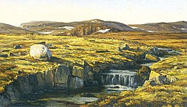
31:Landscape of Germania Land in the summer.
356:
346:
405:
413:
411:
409:
49:
7:
497:
495:
282:In central Germania Land there is a
14:
300:Northeast Greenland National Park
499:
479:
184:
172:
48:
41:
25:
421:. Geological Survey of Denmark
1:
261:German North Polar Expedition
515:. You can help Knowledge by
294:Germania Land is located in
251:This peninsula was named by
275:, the German member of the
583:
494:
344:
204:NE Greenland National Park
185:
567:Greenland geography stubs
351:Map showing Germania Land
168:
159:975 m (3199 ft)
151:54 km (33.6 mi)
143:88 km (54.7 mi)
36:
24:
296:King Frederick VIII Land
562:Peninsulas of Greenland
271:and as a compliment to
511:location article is a
372:
352:
267:in 1869 on the vessel
253:Ludvig Mylius-Erichsen
156:Highest elevation
16:Peninsula in Greenland
361:View of a slope with
360:
350:
314:island lies south of
488:at Wikimedia Commons
323:(Moskusoksefjeldene)
98: /
21:
373:
353:
277:Danmark expedition
257:Danmark expedition
192:Kingdom of Denmark
524:
523:
484:Media related to
377:
376:
371:
320:Musk Ox Mountains
222:
221:
102:77.167°N 20.000°W
574:
545:
538:
531:
503:
496:
483:
467:
462:
456:
455:
453:
451:
437:
431:
430:
428:
426:
415:
366:
343:
342:
255:, leader of the
235:in northeastern
190:
188:
187:
178:
176:
175:
120:
113:
112:
110:
109:
108:
103:
99:
96:
95:
94:
91:
52:
51:
45:
29:
22:
582:
581:
577:
576:
575:
573:
572:
571:
552:
551:
550:
549:
492:
476:
471:
470:
463:
459:
449:
447:
441:"Germania Land"
439:
438:
434:
424:
422:
417:
416:
407:
402:
385:
292:
249:
195:
183:
182:
173:
171:
135:
131:
127:
118:
107:77.167; -20.000
106:
104:
100:
97:
92:
89:
87:
85:
84:
63:
62:
61:
60:
59:
58:
57:
53:
32:
17:
12:
11:
5:
580:
578:
570:
569:
564:
554:
553:
548:
547:
540:
533:
525:
522:
521:
504:
490:
489:
475:
474:External links
472:
469:
468:
457:
432:
404:
403:
401:
398:
397:
396:
389:Koldewey, Carl
384:
381:
375:
374:
354:
312:Store Koldewey
302:, between the
291:
288:
273:Alfred Wegener
248:
245:
220:
219:
216:
212:
211:
207:
206:
201:
197:
196:
169:
166:
165:
164:Administration
161:
160:
157:
153:
152:
149:
145:
144:
141:
137:
136:
123:
121:
115:
114:
82:
78:
77:
76:East Greenland
74:
70:
69:
65:
64:
55:
54:
47:
46:
40:
39:
38:
37:
34:
33:
30:
15:
13:
10:
9:
6:
4:
3:
2:
579:
568:
565:
563:
560:
559:
557:
546:
541:
539:
534:
532:
527:
526:
520:
518:
514:
510:
505:
502:
498:
493:
487:
486:Germania Land
482:
478:
477:
473:
466:
461:
458:
446:
442:
436:
433:
420:
414:
412:
410:
406:
399:
394:
390:
387:
386:
382:
380:
370:
365:near Snenæs.
364:
359:
355:
349:
345:
341:
339:
334:
332:
328:
324:
321:
317:
316:Cape Bismarck
313:
309:
305:
301:
297:
289:
287:
285:
280:
278:
274:
270:
266:
265:Carl Koldewey
262:
258:
254:
246:
244:
242:
238:
234:
230:
226:
225:Germania Land
217:
213:
208:
205:
202:
198:
194:
193:
181:
167:
162:
158:
154:
150:
146:
142:
138:
134:
130:
129:Greenland Sea
126:
122:
116:
111:
83:
79:
75:
71:
66:
56:Germania Land
44:
35:
28:
23:
20:Germania Land
517:expanding it
506:
491:
465:Danmarkshavn
460:
448:. Retrieved
444:
435:
423:. Retrieved
392:
383:Bibliography
378:
368:
338:Danmarkshavn
335:
322:
293:
281:
276:
268:
250:
229:Germanialand
228:
224:
223:
210:Demographics
170:
241:unglaciated
119:Adjacent to
105: /
81:Coordinates
556:Categories
400:References
331:Annex Lake
304:Skaerfjord
215:Population
125:Skaerfjord
509:Greenland
327:Seal Lake
298:, in the
290:Geography
237:Greenland
233:peninsula
180:Greenland
68:Geography
450:24 April
445:Mapcarta
425:21 April
308:Dove Bay
269:Germania
133:Dove Bay
73:Location
391:(1874)
263:led by
247:History
93:20°00′W
90:77°10′N
367:From:
189:
177:
140:Length
507:This
363:Dryas
284:cairn
231:is a
148:Width
513:stub
452:2016
427:2016
336:The
329:and
306:and
200:Zone
227:or
558::
443:.
408:^
379:,
333:.
310:.
279:.
243:.
544:e
537:t
530:v
519:.
454:.
429:.
218:6
Text is available under the Creative Commons Attribution-ShareAlike License. Additional terms may apply.