42:
203:
26:
49:
256:. Steep banks surround the lake which is up to 11 metres deep and has an area of about 3 hectares. Its diameter varies between 170 and 220 metres. The Glaswaldsee is fed by underground water sources; its surface catchment area, apart from an artificial diversion from the uppermost reaches of the
275:
near
Kaltenbronn), but its present name is derived from the former manufacture of glass bottles in the neighbouring villages. Today the surface of the Glaswaldsee is raised by a sandstone wall which used to enable the transportation of timber down river as part of the
295:
valley. To illustrate his approach to the national survey, Mentzinger recorded in the lower part of his map an enlarged view of the
Glaswaldsee with the calculations made by him.
291:
surveyed and mapped. In 1655 Landgrave
Frederick Rudolph of Fürstenberg-Stühlingen directed the Basle priest, Jakob Mentzinger, to prepare a map of his sovereign territory in the
41:
387:
84:
392:
397:
402:
342:
304:
218:
234:
207:
128:
222:
70:
268:
116:
272:
193:
348:
Geodata viewer of the Baden-Württemberg State Office of
Geoinformation and Land Development (
245:
292:
277:
381:
288:
281:
237:. It is part of the nature reserve of the same name that was established in 1960.
241:
336:
99:
86:
202:
347:
25:
253:
249:
226:
117:
129:
359:
Landesanstalt für Umwelt, Messungen und
Naturschutz Baden-Württemberg
230:
287:
The
Glaswaldsee is one of the first lakes of the Black Forest to be
350:
201:
233:
that is sunk into the steep eastern mountainside of the
338:
183:
175:
167:
159:
151:
143:
139:
127:
115:
76:
66:
18:
263:In centuries gone by, the lake was known as the
77:
260:, only covers about an area of 190 hectares.
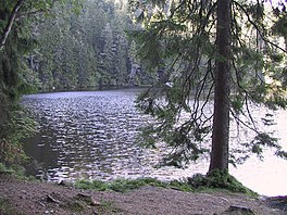
30:The Glaswaldsee near Bad Rippoldsau-Schapbach
8:
244:formed in a cirque that was carved from the
354:, especially with the section maps/layers
15:
316:
7:
48:
364:"LUBW-FG10": watercourses 1:10,000
323:Catchment measured from LUBW-GEZG.
14:
367:"LUBW-SG10": waterbodies 1:10,000
47:
40:
24:
182:
174:
166:
158:
150:
142:
280:industry in the valley of the
206:The Glaswaldsee seen from the
187:839.0 m (2,752.6 ft)
1:
179:0.650 km (0.404 mi)
155:0.170 km (0.106 mi)
147:0.220 km (0.137 mi)
65:
370:"LUBW-GEZG": catchment areas
163:2.9695 ha (7.338 acres)
419:
388:Lakes of Baden-Württemberg
194:not a well-defined measure
393:Tarns of the Black Forest
191:
35:
23:
305:List of lakes of Germany
267:("Wild Lake") (like the
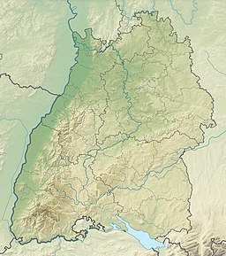
219:Bad Rippoldsau-Schapbach
398:Freudenstadt (district)
210:
171:11 m (36 ft)
271:at Ruhestein and the
217:near the spa town of
205:
100:48.42583°N 08.26194°E
403:Kinzig (Rhine) basin
223:Central Black Forest
96: /
211:
105:48.42583; 08.26194
289:trigonometrically
200:
199:
184:Surface elevation
71:Baden-Württemberg
410:
339:
324:
321:
246:bunter sandstone
235:Lettstädter Höhe
208:Lettstädter Höhe
192:Shore length is
131:
130:Primary outflows
119:
111:
110:
108:
107:
106:
101:
97:
94:
93:
92:
89:
79:
51:
50:
44:
28:
16:
418:
417:
413:
412:
411:
409:
408:
407:
378:
377:
337:
333:
328:
327:
322:
318:
313:
301:
118:Primary inflows
104:
102:
98:
95:
90:
87:
85:
83:
82:
62:
61:
60:
59:
58:
57:
56:
52:
31:
12:
11:
5:
416:
414:
406:
405:
400:
395:
390:
380:
379:
376:
375:
374:
373:
372:
371:
368:
365:
345:
332:
331:External links
329:
326:
325:
315:
314:
312:
309:
308:
307:
300:
297:
278:timber rafting
248:rock out by a
198:
197:
189:
188:
185:
181:
180:
177:
173:
172:
169:
165:
164:
161:
157:
156:
153:
149:
148:
145:
141:
140:
137:
136:
133:
125:
124:
121:
113:
112:
80:
74:
73:
68:
64:
63:
54:
53:
46:
45:
39:
38:
37:
36:
33:
32:
29:
21:
20:
13:
10:
9:
6:
4:
3:
2:
415:
404:
401:
399:
396:
394:
391:
389:
386:
385:
383:
369:
366:
363:
362:
360:
356:
355:
353:
351:
346:
344:
340:
335:
334:
330:
320:
317:
310:
306:
303:
302:
298:
296:
294:
290:
285:
283:
279:
274:
270:
266:
261:
259:
255:
251:
247:
243:
238:
236:
232:
228:
224:
220:
216:
209:
204:
195:
190:
186:
178:
170:
162:
154:
146:
138:
134:
132:
126:
122:
120:
114:
109:
81:
75:
72:
69:
43:
34:
27:
22:
17:
358:
349:
319:
286:
264:
262:
257:
252:during the
239:
214:
212:
176:Shore length
160:Surface area
215:Glaswaldsee
144:Max. length
103: /
78:Coordinates
55:Glaswaldsee
19:Glaswaldsee
382:Categories
311:References
265:Wilder See
229:lies in a
168:Max. depth
152:Max. width
88:48°25′33″N
91:8°15′43″E
299:See also
67:Location
361:(LUBW)
357:by the
343:YouTube
273:Wildsee
269:Wildsee
258:Seebach
254:ice age
250:glacier
227:Germany
221:in the
135:Seebach
123:Seebach
293:Kinzig
231:cirque
282:Wolf
242:tarn
240:The
213:The
341:on
225:in
384::
284:.
352:)
196:.
Text is available under the Creative Commons Attribution-ShareAlike License. Additional terms may apply.