506:
439:
55:
40:
723:
497:
Because it flows through some of the richest forest districts, it has historically been Norway's leading log-floating river. The combination of raw materials, water power, and easy transport has over the centuries encouraged industry along the Glomma. Some of the country's largest manufacturing and
532:, slightly lower than in the Gudbrandsdalen, which reflects the colder climate. The treeline, with a light birch forest, rises to about 900 metres (3,000 ft) in Østerdalen. Above Røros the forest is restricted to the valley floor.
535:
The upper river valleys of
Norwegian rivers have distinctive names which are vestiges of earlier cultural distinctions such as building styles, traditional clothing or
626:
554:, the Glomma has formed Europe's largest inland delta which reaches the opposite side of the lake, across its short axis. Some of the vast amount of
45:
758:
753:
768:
230:
748:
704:
743:
763:
145:
487:
727:
505:
651:
369:
674:
430:
that covers fully 13% of Norway's surface area, all in the southern part of the country.
438:
547:
491:
427:
737:
529:
483:
587:
459:
127:
540:
467:
208:
196:
191:
54:
39:
610:
575:
499:
212:
498:
processing concerns are found around its mouth, where supplies of timber and
245:
232:
160:
147:
599:
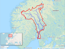
583:
525:
514:
463:
68:
17:
614:
722:
528:
farms is variable, but typically runs about 500 metres (1,600 ft) in
579:
518:
479:
475:
455:
354:
123:
559:
551:
451:
443:
111:
419:
216:
131:
92:
558:
that the Glomma deposits in Lake Øyeren is extracted to manufacture
646:
536:
510:
504:
471:
437:
423:
342:
555:
562:
widely used for in the construction of foundations in Norway.
426:. With a total length of 621 kilometres (386 miles), it has a
539:
and domestic crafts. The upper valley of the Glomma is the
490:
drains into Lake Mjøsa, collecting drainage from the large
609:
Several places are named after the river, for instance
392:
384:
376:
367:
360:
348:
336:
328:
323:
309:
299:
291:
279:
271:
261:
222:
202:
190:
176:
137:
117:
107:
98:
88:
83:
64:
32:
606:, meaning a "loud noise" or "thunder" + "river".
494:and significantly increasing the Glomma's flow.
502:have been backed by excellent port facilities.
627:Category:Populated places on the Glomma River
8:
688:Fullerton, Brian; Williams, Alan F. (1972).
590:counties the river is called (and written)
450:At its fullest length, the river runs from
315:4,700 m/s (170,000 cu ft/s)
53:
638:
305:720 m/s (25,000 cu ft/s)
283:42,000 km (16,000 sq mi)
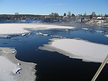
46:Solbergfoss Hydroelectric Power Station
690:Scandinavia: An Introductory Geography
517:, flows into the Glomma just north of
29:
391:
383:
375:
366:
7:
708:(London: Nelson, 1960), p. 67 fn. 4.
25:
705:The Saga of King Heidrek the Wise
59:Map of the Glomma River watershed
721:
470:. Major tributaries include the
38:
702:Tolkien, Christopher (trans.),
692:. New York: Praeger Publishers.
422:'s longest and most voluminous
478:, joining the Glomma River at
224: • coordinates
139: • coordinates
1:
99:Physical characteristics
263: • elevation
178: • elevation
204: • location
119: • location
785:
311: • maximum
301: • average
182:690 m (2,260 ft)
654:Sites Information Service
404:
400:
319:
287:
275:621 km (386 mi)
186:
103:
52:
37:
350: • right
524:The upper limit of the
338: • left
759:Ramsar sites in Norway
521:
447:
594:. An older form was
508:
441:
246:59.21778°N 10.93083°E
161:62.61833°N 11.80306°E
730:at Wikimedia Commons
560:LECA building blocks
474:River, which drains
267:0 m (0 ft)
754:Rivers of Trøndelag
749:Rivers of Innlandet
582:counties, while in
324:Basin features
242: /
157: /
79:: "noise," "racket"
744:Rivers of Akershus
543:(or East Valley).
522:
462:and runs into the
448:
393:Reference no.
251:59.21778; 10.93083
166:62.61833; 11.80306
44:The Glomma at the
769:Rivers of Østfold
726:Media related to
408:
407:
16:(Redirected from
776:
764:Rivers of Norway
725:
709:
700:
694:
693:
685:
679:
678:
671:
665:
664:
662:
660:
643:
388:12 November 2010
351:
339:
312:
302:
257:
256:
254:
253:
252:
247:
243:
240:
239:
238:
235:
179:
172:
171:
169:
168:
167:
162:
158:
155:
154:
153:
150:
140:
120:
57:
42:
30:
21:
784:
783:
779:
778:
777:
775:
774:
773:
734:
733:
718:
713:
712:
701:
697:
687:
686:
682:
673:
672:
668:
658:
656:
645:
644:
640:
635:
623:
568:
446:, during winter
436:
372:
349:
337:
310:
300:
264:
250:
248:
244:
241:
236:
233:
231:
229:
228:
225:
205:
177:
165:
163:
159:
156:
151:
148:
146:
144:
143:
138:
118:
60:
48:
28:
27:River in Norway
23:
22:
15:
12:
11:
5:
782:
780:
772:
771:
766:
761:
756:
751:
746:
736:
735:
732:
731:
717:
716:External links
714:
711:
710:
695:
680:
666:
647:"Glomådeltaet"
637:
636:
634:
631:
630:
629:
622:
619:
598:; another, in
567:
564:
546:Upon entering
492:Gudbrandsdalen
442:The Glomma at
435:
432:
428:drainage basin
406:
405:
402:
401:
398:
397:
394:
390:
389:
386:
382:
381:
378:
374:
373:
370:Ramsar Wetland
368:
365:
364:
362:
358:
357:
352:
346:
345:
340:
334:
333:
330:
326:
325:
321:
320:
317:
316:
313:
307:
306:
303:
297:
296:
293:
289:
288:
285:
284:
281:
277:
276:
273:
269:
268:
265:
262:
259:
258:
226:
223:
220:
219:
206:
203:
200:
199:
194:
188:
187:
184:
183:
180:
174:
173:
141:
135:
134:
121:
115:
114:
109:
105:
104:
101:
100:
96:
95:
90:
86:
85:
81:
80:
66:
62:
61:
58:
50:
49:
43:
35:
34:
33:Glomma / Glåma
26:
24:
14:
13:
10:
9:
6:
4:
3:
2:
781:
770:
767:
765:
762:
760:
757:
755:
752:
750:
747:
745:
742:
741:
739:
729:
724:
720:
719:
715:
707:
706:
699:
696:
691:
684:
681:
676:
670:
667:
655:
653:
648:
642:
639:
632:
628:
625:
624:
620:
618:
616:
612:
607:
605:
601:
597:
593:
589:
585:
581:
577:
573:
565:
563:
561:
557:
553:
549:
544:
542:
538:
533:
531:
527:
526:Glomma valley
520:
516:
512:
507:
503:
501:
495:
493:
489:
485:
481:
477:
473:
469:
465:
461:
457:
453:
445:
440:
433:
431:
429:
425:
421:
417:
413:
403:
399:
395:
387:
379:
377:Official name
371:
363:
359:
356:
353:
347:
344:
341:
335:
331:
327:
322:
318:
314:
308:
304:
298:
294:
290:
286:
282:
278:
274:
270:
266:
260:
255:
227:
221:
218:
214:
210:
207:
201:
198:
195:
193:
189:
185:
181:
175:
170:
142:
136:
133:
129:
125:
122:
116:
113:
110:
106:
102:
97:
94:
91:
87:
82:
78:
74:
70:
67:
63:
56:
51:
47:
41:
36:
31:
19:
703:
698:
689:
683:
677:. June 2012.
675:"Til kilden"
669:
657:. Retrieved
650:
641:
608:
603:
595:
591:
571:
569:
545:
534:
523:
496:
449:
415:
411:
409:
380:Glomådeltaet
76:
72:
18:Glomådeltaet
574:is used in
548:Lake Øyeren
468:Fredrikstad
361:Designation
329:Tributaries
249: /
209:Fredrikstad
197:Fredrikstad
164: /
738:Categories
633:References
530:Østerdalen
513:, a major
500:hydropower
476:Lake Mjøsa
454:lake near
385:Designated
280:Basin size
237:10°55′51″E
234:59°13′04″N
152:11°48′11″E
149:62°37′06″N
600:Old Norse
588:Trøndelag
584:Innlandet
570:The form
515:tributary
464:Oslofjord
460:Trøndelag
434:Geography
292:Discharge
128:Trøndelag
69:Old Norse
65:Etymology
659:25 April
621:See also
604:Raumelfr
580:Akershus
541:Østerdal
84:Location
611:Glåmdal
576:Østfold
552:Fetsund
452:Aursund
444:Elverum
213:Østfold
112:Aursund
89:Country
75:, from
728:Glomma
652:Ramsar
615:Glåmos
602:, was
596:Glaumr
572:Glomma
486:. The
420:Norway
412:Glomma
332:
295:
272:Length
217:Norway
132:Norway
108:Source
93:Norway
73:Glaumr
592:Glåma
537:bunad
519:Årnes
511:Vorma
488:Lågen
480:Årnes
472:Vorma
456:Røros
424:river
418:, is
416:Glåma
414:, or
343:Vorma
192:Mouth
124:Røros
77:raumr
661:2018
613:and
586:and
578:and
566:Name
556:silt
509:The
410:The
396:1954
355:Rena
550:at
484:Nes
482:in
466:at
458:in
740::
649:.
617:.
215:,
211:,
130:,
126:,
71:,
663:.
20:)
Text is available under the Creative Commons Attribution-ShareAlike License. Additional terms may apply.