326:
75:
70:
65:
40:
401:
391:
411:
367:
271:
416:
386:
229:
90:
421:
396:
262:
were still in use on an active mainline anywhere in North
America. They were retired and replaced with modern signals in November 2022.
360:
221:
199:
282:
353:
141:
100:
86:
82:
191:
133:
117:
78:
225:
259:
406:
171:
151:
Historically, the pass provided the most direct route through the mountains between the upper valley of the
258:, with one passenger train each direction daily, but little freight. It was one of the last places where
217:
The stairwells of the
Colorado State Capitol Building display cannonballs from the battle as ornaments.
140:. The pass is at a strategic location near at the southern end of the Sangre de Cristos in east central
232:
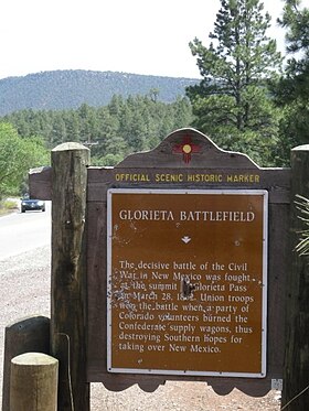
in 1899, and the Santa Fe used the route for their
Chicago to Los Angeles trains, including the famed
211:
145:
175:
50:
233:
179:
337:
187:
254:
203:
195:
224:
constructed a railroad through the pass, which became part of the second North
American
202:
on the east side of the pass. In the 20th century, the pass became used as the route of
159:
to the west. In the 19th century, it furnished the route of the westernmost leg of the
325:
160:
112:
380:
207:
129:
105:
17:
164:
240:
152:
333:
186:(primarily in the form of the Colorado Militia) prevented the breakout of the
183:
156:
137:
297:
284:
194:, halting the intended Confederate advance northward along the base of the
276:, a National Park Service Teaching with Historic Places (TwHP) lesson plan
39:
228:
in March 1881. The NM&SP was absorbed into its parent company, the
249:
245:
182:, was fought near the pass in March 1862. The victory by the
341:
273:
Glorieta and Raton Passes: Gateways to the
Southwest
111:
96:
59:
49:
32:
190:forces onto the High Plains on the east side of
402:Transportation in Santa Fe County, New Mexico
361:
8:
214:is located on the eastern side of the pass.
368:
354:
29:
27:Mountain pass in New Mexico, United States
392:Rail mountain passes of the United States
412:Landforms of Santa Fe County, New Mexico
222:New Mexico and Southern Pacific Railroad
155:to the east and the upper valley of the
230:Atchison Topeka and Santa Fe Railroad
7:
322:
320:
91:Burlington Northern Santa Fe Railway
340:. You can help Knowledge (XXG) by
248:system, this remains the route of
25:
324:
198:. The battle is commemorated at
73:
68:
63:
38:
128:(elevation 7500 ft.) is a
417:Mountain passes of the Rockies
1:
387:Mountain passes of New Mexico
174:, the decisive battle of the
336:state location article is a
200:Pecos National Historic Park
101:Santa Fe County, New Mexico
44:Glorieta Battlefield Marker
438:
422:New Mexico geography stubs
397:Sangre de Cristo Mountains
319:
192:Sangre de Cristo Mountains
134:Sangre de Cristo Mountains
118:Sangre de Cristo Mountains
226:transcontinental railroad
163:between Santa Fe and the
144:southeast of the city of
37:
172:Battle of Glorieta Pass
298:35.59139°N 105.77778°W
303:35.59139; -105.77778
18:Glorieta Subdivision
294: /
176:New Mexico Campaign
244:. Now part of the
180:American Civil War
55:7,500 ft (2,286 m)
349:
348:
260:semaphore signals
123:
122:
16:(Redirected from
429:
370:
363:
356:
328:
321:
309:
308:
306:
305:
304:
299:
295:
292:
291:
290:
287:
188:Confederate Army
77:
76:
72:
71:
67:
66:
42:
30:
21:
437:
436:
432:
431:
430:
428:
427:
426:
377:
376:
375:
374:
317:
315:
302:
300:
296:
293:
288:
285:
283:
281:
280:
268:
255:Southwest Chief
204:U.S. Highway 84
196:Rocky Mountains
142:Santa Fe County
104:
89:
74:
69:
64:
45:
28:
23:
22:
15:
12:
11:
5:
435:
433:
425:
424:
419:
414:
409:
407:Santa Fe Trail
404:
399:
394:
389:
379:
378:
373:
372:
365:
358:
350:
347:
346:
329:
314:
311:
278:
277:
267:
266:External links
264:
210:. The town of
161:Santa Fe Trail
121:
120:
115:
109:
108:
98:
94:
93:
61:
57:
56:
53:
47:
46:
43:
35:
34:
26:
24:
14:
13:
10:
9:
6:
4:
3:
2:
434:
423:
420:
418:
415:
413:
410:
408:
405:
403:
400:
398:
395:
393:
390:
388:
385:
384:
382:
371:
366:
364:
359:
357:
352:
351:
345:
343:
339:
335:
330:
327:
323:
318:
312:
310:
307:
275:
274:
270:
269:
265:
263:
261:
257:
256:
251:
247:
243:
242:
237:
236:
231:
227:
223:
220:In 1879, the
218:
215:
213:
209:
208:Interstate 25
205:
201:
197:
193:
189:
185:
181:
177:
173:
168:
166:
162:
158:
154:
149:
147:
143:
139:
135:
131:
130:mountain pass
127:
126:Glorieta Pass
119:
116:
114:
110:
107:
106:United States
102:
99:
95:
92:
88:
84:
80:
62:
58:
54:
52:
48:
41:
36:
33:Glorieta Pass
31:
19:
342:expanding it
331:
316:
279:
272:
253:
239:
234:
219:
216:
169:
150:
136:of northern
125:
124:
60:Traversed by
301: /
289:105°46′40″W
241:Super Chief
165:High Plains
153:Pecos River
381:Categories
334:New Mexico
313:References
286:35°35′29″N
235:El Capitan
206:and later
184:Union Army
157:Rio Grande
138:New Mexico
87:US 85
83:US 84
51:Elevation
212:Glorieta
146:Santa Fe
97:Location
85: /
81: /
178:of the
132:in the
250:Amtrak
332:This
113:Range
338:stub
246:BNSF
238:and
170:The
79:I-25
252:'s
383::
167:.
148:.
369:e
362:t
355:v
344:.
103:,
20:)
Text is available under the Creative Commons Attribution-ShareAlike License. Additional terms may apply.