44:
31:
51:
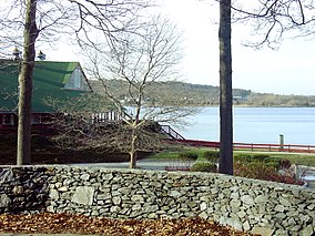
199:, whose children gave the land to the state in 1927 as a memorial to their father. The park features a nine-hole golf course, an equestrian area with 18 miles (29 km) of bridle trails, swimming beach, canoeing area, picnicking facilities, game fields, and a performing arts center.
354:
699:
719:
398:
43:
383:
347:
714:
709:
86:
511:
650:
340:
233:
577:
408:
393:
375:
640:
597:
388:
694:
363:
224:
673:
569:
466:
529:
403:
559:
521:
433:
423:
229:
704:
176:
610:
630:
587:
582:
486:
549:
539:
476:
446:
491:
451:
196:
146:
219:
668:
658:
554:
544:
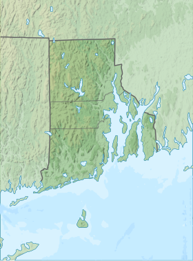
247:
534:
501:
471:
456:
441:
180:
70:
506:
175:
is a public recreation area occupying 490 acres (200 ha) along the shores of
Greenwich Cove and
663:
496:
192:
30:
620:
320:
635:
625:
461:
413:
326:
295:
164:
615:
329:
Rhode Island
Department of Environmental Management Division of Parks & Recreation
323:
Rhode Island
Department of Environmental Management Division of Parks & Recreation
156:
Rhode Island
Department of Environmental Management Division of Parks & Recreation
688:
605:
273:
74:
418:
367:
184:
332:
188:
101:
88:
250:. State of Rhode Island Division of Parks & Recreation. Archived from
251:
336:
298:. State of Rhode Island Division of Parks & Recreation
276:. State of Rhode Island Division of Parks & Recreation
399:
Narragansett Bay
National Estuarine Research Reserve
649:
596:
568:
520:
432:
374:
160:
152:
141:
133:
125:
117:
80:
66:
50:
23:
384:Blackstone River Valley National Historical Park
348:
8:
700:Protected areas of Kent County, Rhode Island
720:Civilian Conservation Corps in Rhode Island
355:
341:
333:
20:
234:United States Department of the Interior
409:Sachuest Point National Wildlife Refuge
208:
16:State park in Kent County, Rhode Island
414:Touro Synagogue National Historic Site
214:
212:
419:Trustom Pond National Wildlife Refuge
389:Block Island National Wildlife Refuge
274:"Goddard Memorial State Park History"
7:
195:officer and Rhode Island politician
65:
715:1927 establishments in Rhode Island
710:Protected areas established in 1927
225:Geographic Names Information System
674:George Washington State Campground
14:
404:Ninigret National Wildlife Refuge
424:Roger Williams National Memorial
191:grounds were once the estate of
49:
42:
29:
394:Chafee National Wildlife Refuge
327:Goddard Memorial State Park Map
230:United States Geological Survey
132:
512:World War II Veterans Memorial
1:
296:"Goddard Memorial State Park"
248:"Goddard Memorial State Park"
695:State parks of Rhode Island
321:Goddard Memorial State Park
173:Goddard Memorial State Park
165:Goddard Memorial State Park
121:489.2 acres (198.0 ha)
24:Goddard Memorial State Park
736:
578:George Washington Memorial
447:Blackstone River Greenway
37:
28:
58:Location in Rhode Island
659:Arcadia Management Area
598:Wild and Scenic Rivers
129:39 ft (12 m)
705:Warwick, Rhode Island
651:Other protected areas
530:Charlestown Breachway
102:41.65556°N 71.43583°W
71:Warwick, Rhode Island
467:Fishermen's Memorial
254:on February 4, 2005
107:41.65556; -71.43583
98: /
664:East Bay Bike Path
682:
681:
170:
169:
727:
621:Green Fall River
482:Goddard Memorial
357:
350:
343:
334:
308:
307:
305:
303:
292:
286:
285:
283:
281:
270:
264:
263:
261:
259:
244:
238:
237:
220:"Potowomut Neck"
216:
113:
112:
110:
109:
108:
103:
99:
96:
95:
94:
91:
53:
52:
46:
33:
21:
735:
734:
730:
729:
728:
726:
725:
724:
685:
684:
683:
678:
645:
636:Usquepaug River
626:Pawcatuck River
592:
564:
516:
487:Haines Memorial
428:
370:
364:Protected areas
361:
317:
312:
311:
301:
299:
294:
293:
289:
279:
277:
272:
271:
267:
257:
255:
246:
245:
241:
218:
217:
210:
205:
106:
104:
100:
97:
92:
89:
87:
85:
84:
62:
61:
60:
59:
56:
55:
54:
17:
12:
11:
5:
733:
731:
723:
722:
717:
712:
707:
702:
697:
687:
686:
680:
679:
677:
676:
671:
666:
661:
655:
653:
647:
646:
644:
643:
638:
633:
628:
623:
618:
616:Chipuxet River
613:
608:
602:
600:
594:
593:
591:
590:
585:
580:
574:
572:
566:
565:
563:
562:
557:
552:
547:
542:
537:
532:
526:
524:
518:
517:
515:
514:
509:
504:
499:
494:
489:
484:
479:
477:Fort Wetherill
474:
469:
464:
459:
454:
449:
444:
438:
436:
430:
429:
427:
426:
421:
416:
411:
406:
401:
396:
391:
386:
380:
378:
372:
371:
362:
360:
359:
352:
345:
337:
331:
330:
324:
316:
315:External links
313:
310:
309:
287:
265:
239:
207:
206:
204:
201:
197:Robert Goddard
168:
167:
162:
158:
157:
154:
150:
149:
147:Robert Goddard
143:
139:
138:
135:
131:
130:
127:
123:
122:
119:
115:
114:
82:
78:
77:
68:
64:
63:
57:
48:
47:
41:
40:
39:
38:
35:
34:
26:
25:
15:
13:
10:
9:
6:
4:
3:
2:
732:
721:
718:
716:
713:
711:
708:
706:
703:
701:
698:
696:
693:
692:
690:
675:
672:
670:
667:
665:
662:
660:
657:
656:
654:
652:
648:
642:
639:
637:
634:
632:
629:
627:
624:
622:
619:
617:
614:
612:
609:
607:
606:Ashaway River
604:
603:
601:
599:
595:
589:
586:
584:
583:Lincoln Woods
581:
579:
576:
575:
573:
571:
570:State Forests
567:
561:
558:
556:
553:
551:
550:Roger Wheeler
548:
546:
543:
541:
540:East Matunuck
538:
536:
533:
531:
528:
527:
525:
523:
522:State Beaches
519:
513:
510:
508:
505:
503:
500:
498:
495:
493:
492:Lincoln Woods
490:
488:
485:
483:
480:
478:
475:
473:
470:
468:
465:
463:
460:
458:
455:
453:
452:Brenton Point
450:
448:
445:
443:
440:
439:
437:
435:
431:
425:
422:
420:
417:
415:
412:
410:
407:
405:
402:
400:
397:
395:
392:
390:
387:
385:
382:
381:
379:
377:
373:
369:
365:
358:
353:
351:
346:
344:
339:
338:
335:
328:
325:
322:
319:
318:
314:
297:
291:
288:
275:
269:
266:
253:
249:
243:
240:
235:
231:
227:
226:
221:
215:
213:
209:
202:
200:
198:
194:
190:
186:
182:
178:
177:Greenwich Bay
174:
166:
163:
159:
155:
153:Administrator
151:
148:
144:
140:
136:
128:
124:
120:
116:
111:
83:
79:
76:
75:United States
72:
69:
45:
36:
32:
27:
22:
19:
611:Beaver River
481:
368:Rhode Island
300:. Retrieved
290:
278:. Retrieved
268:
256:. Retrieved
252:the original
242:
223:
185:Rhode Island
172:
171:
18:
631:Queen River
560:Scarborough
555:Salty Brine
545:Misquamicut
502:Rocky Point
434:State Parks
258:January 27,
134:Established
105: /
81:Coordinates
689:Categories
641:Wood River
588:Wickaboxet
535:East Beach
472:Fort Adams
457:Burlingame
442:Beavertail
302:August 26,
280:August 26,
203:References
189:state park
90:41°39′20″N
507:Snake Den
193:Civil War
142:Named for
126:Elevation
93:71°26′9″W
669:Ell Pond
67:Location
497:Pulaski
376:Federal
181:Warwick
161:Website
187:. The
145:Col.
462:Colt
304:2014
282:2014
260:2023
137:1927
118:Area
366:of
179:in
691::
232:,
228:.
222:.
211:^
183:,
73:,
356:e
349:t
342:v
306:.
284:.
262:.
236:.
Text is available under the Creative Commons Attribution-ShareAlike License. Additional terms may apply.