45:
61:
68:
60:
235:
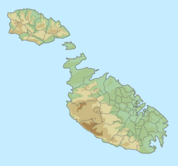
It is about 7 km (4.3 mi) long and varies in width from 6.7 km (4.2 mi) at its widest to 4.5 km (2.8 mi) at its northeastern end. At the centre of the channel are the two islands of
24:
362:
367:
205:
121:
302:
382:
377:
277:
335:
387:
245:
44:
249:
221:
107:
20:
253:
97:
372:
356:
153:
158:
257:
19:
This article is about the body of water. For the ferry across this channel, see
306:
248:
serves as a sea route link between the two islands with a ferry service run by
136:
123:
241:
237:
229:
225:
93:
327:
278:"Gozo – The gap can be bridged: by Dr. Franco Mercieca"
204:
200:
192:
184:
176:
168:
164:
152:
113:
103:
88:
32:
114:
8:
29:
16:Channel between the islands Gozo and Malta
252:running all year round from the ports of
269:
25:Malta–Gozo Channel Important Bird Area
80:Location of the Gozo Channel in Malta
7:
67:
188:27.4 km (10.6 sq mi)
23:. For the important bird area, see
14:
363:Channels of the Mediterranean Sea
303:"Gozo Channel Ferries, timetable"
224:separating the Maltese island of
66:
59:
43:
338:from the original on 2021-12-30
191:
183:
175:
167:
1:
87:
404:
18:
228:from the northern tip of
180:6.7 km (4.2 mi)
172:5.5 km (3.4 mi)
54:
42:
37:
368:Bodies of water of Malta
196:26 m (85 ft)
220:is short stretch of
133: /
38:Il-Fliegu t'Ghawdex
383:Channels of Europe
250:Gozo Channel Line
222:Mediterranean Sea
214:
213:
108:Mediterranean Sea
21:Gozo Channel Line
395:
347:
346:
344:
343:
324:
318:
317:
315:
314:
305:. Archived from
299:
293:
292:
290:
289:
274:
240:(inhabited) and
148:
147:
145:
144:
143:
138:
134:
131:
130:
129:
126:
116:
70:
69:
63:
49:The Gozo Channel
47:
30:
403:
402:
398:
397:
396:
394:
393:
392:
378:Coasts of Malta
353:
352:
351:
350:
341:
339:
326:
325:
321:
312:
310:
301:
300:
296:
287:
285:
276:
275:
271:
266:
141:
139:
137:36.00°N 14.31°E
135:
132:
127:
124:
122:
120:
119:
84:
83:
82:
81:
78:
77:
76:
75:
71:
50:
28:
17:
12:
11:
5:
401:
399:
391:
390:
385:
380:
375:
370:
365:
355:
354:
349:
348:
328:"Gozo Channel"
319:
294:
268:
267:
265:
262:
212:
211:
208:
202:
201:
198:
197:
194:
190:
189:
186:
182:
181:
178:
174:
173:
170:
166:
165:
162:
161:
156:
150:
149:
117:
111:
110:
105:
101:
100:
98:Malta (island)
90:
86:
85:
79:
73:
72:
65:
64:
58:
57:
56:
55:
52:
51:
48:
40:
39:
35:
34:
15:
13:
10:
9:
6:
4:
3:
2:
400:
389:
386:
384:
381:
379:
376:
374:
371:
369:
366:
364:
361:
360:
358:
337:
333:
329:
323:
320:
309:on 2012-08-14
308:
304:
298:
295:
283:
279:
273:
270:
263:
261:
259:
255:
254:Mġarr Harbour
251:
247:
243:
239:
233:
231:
227:
223:
219:
209:
207:
203:
199:
195:
187:
179:
171:
163:
160:
157:
155:
151:
146:
118:
112:
109:
106:
102:
99:
95:
91:
62:
53:
46:
41:
36:
31:
26:
22:
388:Gozo Channel
340:. Retrieved
332:Gozo Channel
331:
322:
311:. Retrieved
307:the original
297:
286:. Retrieved
284:. 2011-02-05
281:
272:
234:
218:Gozo Channel
217:
215:
185:Surface area
142:36.00; 14.31
74:Gozo Channel
33:Gozo Channel
169:Max. length
140: /
115:Coordinates
357:Categories
342:2021-12-30
313:2012-03-01
288:2021-12-30
264:References
193:Max. depth
177:Max. width
282:Gozo News
242:Cominotto
336:Archived
258:Ċirkewwa
92:Between
89:Location
246:channel
206:Islands
128:14°19′E
125:36°00′N
244:. The
238:Comino
159:Saline
230:Malta
104:Group
373:Gozo
256:and
226:Gozo
216:The
154:Type
96:and
94:Gozo
359::
334:.
330:.
280:.
260:.
232:.
345:.
316:.
291:.
210:4
27:.
Text is available under the Creative Commons Attribution-ShareAlike License. Additional terms may apply.