98:
1118:
635:
82:
1123:
105:
434:
In August 1895, tenders were called for the erection of a provisional school at
Grantham Scrub. In January 1896 teacher, Catherine M. Ludeman was appointed to the Grantham Scrub Provisional School, suggesting it opened around that time. On 1 January 1909, it became Grantham Scrub State School. It
507:
also visited the town. In May 2011, it was announced that the town would be moved to higher ground to prevent future damaging floods. A 935-acre site was purchased so that landholders could be provided a voluntary swap of equivalent-sized blocks. The new site is situated on a hill overlooking
536:, the locality of Grantham had a population of 634 people. 81.1% of people were born in Australia and 90.9% of people spoke only English at home. The most common responses for religion were No Religion 24.3%, Catholic 17.8% and Anglican 15.5%.
1199:
438:
1147:
1025:
130:
810:
778:
746:
554:
280:
268:
1195:
1970:
1855:
1598:
1716:
1258:
958:
928:
713:
868:
679:
650:
499:. 12 people died and a large number of houses and other buildings were destroyed. Following the floods, Grantham received visits by politicians including
246:
2025:
1052:
2198:
989:
1139:
1017:
524:
have been included in the fast-tracked plan. As of March 2022, 110 houses are on the hill but over 50 dwellings remain in the older part of town.
97:
1603:
994:
853:
1685:
428:
234:
1930:
1709:
1251:
373:
2188:
1995:
845:
725:
815:
783:
751:
258:
496:
1096:
613:
251:
2193:
2030:
1702:
1443:
1244:
508:
Grantham and has permission from the state government to bypass the normal development approval process. Residents of nearby
924:
1236:
485:
A butter factory was established in 1907. The building was replaced in 1926 by a brick building which operated until 1971.
2065:
1990:
1960:
591:). In 2017, the school had an enrolment of 95 students with 6 teachers and 6 non-teaching staff (4 full-time equivalent).
424:
273:
1074:
2183:
1980:
1965:
1955:
1910:
1528:
1428:
1293:
123:
23:
1875:
1870:
1623:
1473:
1448:
1363:
2015:
2000:
1985:
1975:
1890:
1885:
1804:
1653:
1633:
1588:
1553:
1518:
1498:
1493:
1463:
951:
513:
353:
308:
2070:
2035:
1915:
1905:
1628:
1563:
1538:
1458:
1453:
1423:
1388:
1313:
509:
2045:
1950:
1935:
1920:
1865:
1643:
1593:
1543:
1523:
1358:
1338:
1333:
332:
2152:
2083:
2040:
1940:
1880:
1845:
1648:
1513:
1508:
1408:
1398:
1373:
1348:
1048:
427:
was opened which assisted in the development of a small settlement. It wasn't until the mid-1870s that the
50:
2060:
2050:
1895:
1825:
1799:
1608:
1383:
1328:
1323:
1308:
1298:
1100:
617:
540:
533:
482:
Grantham
Provisional School opened on 23 January 1905. On 1 January 1909 it became Grantham State School.
389:
339:
191:
175:
404:
passes through from east to west. The north-west corner is occupied by part of the
Lockyer State Forest.
45:
2132:
2075:
2055:
2020:
1945:
1820:
1778:
1725:
1673:
1638:
1573:
1433:
1413:
1368:
1343:
1272:
1268:
1143:
902:
872:
687:
658:
476:
377:
344:
239:
551:
Grantham State School is a government primary (Prep-6) school for boys and girls at 15 Victor Street (
2010:
1925:
1668:
1663:
1613:
1578:
1568:
1533:
1483:
1478:
1303:
1229:
517:
313:
40:
2127:
2005:
1840:
1835:
1763:
1658:
1618:
1583:
1558:
1503:
1488:
1438:
1418:
1403:
1288:
984:
521:
348:
320:
303:
81:
2157:
1748:
1378:
1318:
328:
285:
2122:
1900:
1468:
1353:
1283:
1075:"'If there's higher ground, do it': The flood-prone Queensland community that moved up a hill"
849:
721:
217:
1743:
489:
2117:
2112:
1753:
1225:
401:
1117:
634:
435:
closed circa 1950. It was located at 119 Missouri Road (corner of
Grantham Scrub Road,
384:, Australia. The town is located 100 kilometres (62 mi) west of the state capital,
2142:
2102:
1768:
420:
2177:
2107:
782:. Vol. XXXVI, no. 5390. Queensland, Australia. 25 January 1896. p. 5.
504:
1694:
750:. Vol. XXXVI, no. 5322. Queensland, Australia. 17 August 1895. p. 5.
35:
2162:
1773:
814:. Vol. XXXVI, no. 5454. Queensland, Australia. 23 June 1896. p. 3.
412:
The area was first settled in 1841, by George
Mocatta. He named his pastoral run
2137:
1127:
2147:
1758:
1729:
805:
773:
741:
500:
381:
226:
72:
570:
556:
454:
440:
146:
132:
1830:
1548:
894:
1794:
385:
1122:
1126:
Material was copied from this source, which is available under a
1169:
222:
1698:
1240:
1226:"Grantham is a town left in tatters (Video of flood damage)"
680:"Grantham – locality in Lockyer Valley Region (entry 44957)"
543:, the locality of Grantham had a population of 796 people.
392:, the locality of Grantham had a population of 796 people.
651:"Grantham – town in Lockyer Valley Region (entry 14609)"
811:
Queensland Times, Ipswich Herald And
General Advertiser
779:
Queensland Times, Ipswich Herald And
General Advertiser
747:
Queensland Times, Ipswich Herald And
General Advertiser
495:
On 10 January 2011, Grantham was severely damaged in a
1128:
Creative
Commons Attribution 4.0 International License
503:
on numerous occasions. Australia's
Governor-General
2093:
1854:
1813:
1787:
1736:
279:
267:
257:
245:
233:
216:
208:
200:
190:
182:
170:
122:
66:
475:) within the present-day locality of neighbouring
488:Grantham Post Office opened on 1 January 1890 (a
292:
1049:"Flood-ravaged Grantham moves to higher ground"
1710:
1252:
8:
714:Environmental Protection Agency (Queensland)
608:
606:
604:
1717:
1703:
1695:
1259:
1245:
1237:
1116:
840:Queensland Family History Society (2010),
826:– via National Library of Australia.
794:– via National Library of Australia.
762:– via National Library of Australia.
708:
706:
704:
633:
80:
63:
1018:"Flooded Queensland town to be relocated"
990:Gatton, Lockyer and Brisbane Valley Star
952:"Grantham Floods Commission of Inquiry"
718:Heritage Trails of the Great South East
600:
835:
833:
806:"The Department of Public Instruction"
645:
643:
1202:from the original on 22 November 2018
1150:from the original on 21 November 2018
818:from the original on 25 February 2022
786:from the original on 25 February 2022
754:from the original on 25 February 2022
337:
318:
301:
294:
7:
1686:Local government areas of Queensland
1140:"State and non-state school details"
466:Grantham Scrub State School (former)
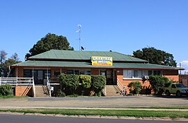
86:Grantham Hotel, located in Anzac Ave
1971:Gheebulum Kunungai (Moreton Island)
842:Queensland schools past and present
720:. State of Queensland. p. 61.
416:which became the name of the town.
212:49.3 km (19.0 sq mi)
1028:from the original on 13 March 2012
997:from the original on 25 March 2012
964:from the original on 13 March 2021
14:
1055:from the original on 15 June 2011
950:Walter Sofronoff (October 2015).
846:Queensland Family History Society
1121:
983:Tom Threadingham (24 May 2011).
931:from the original on 15 May 2014
104:
103:
96:
1097:Australian Bureau of Statistics
1047:Matt Wordsworth (8 June 2011).
895:"Layers: Locality; Land parcel"
614:Australian Bureau of Statistics
1:
1016:Georgia Waters (5 May 2011).
501:Queensland Premier Anna Bligh
61:Town in Queensland, Australia
2026:Southern Moreton Bay Islands
1267:Towns and localities in the
186:16.146/km (41.82/sq mi)
2199:2010–2011 Queensland floods
1196:"ACARA School Profile 2017"
927:. Premier Postal Auctions.
297:Localities around Grantham:
51:GPX (secondary coordinates)
2215:
774:"The Education Department"
492:had been open from 1876).
1682:
1279:
1077:. ABC News. 12 March 2022
844:(Version 1.01 ed.),
359:
295:
291:
91:
79:
46:GPX (primary coordinates)
21:Map all coordinates using
2189:Localities in Queensland
923:Premier Postal History.
429:Grantham railway station
204:109 m (358 ft)
29:Download coordinates as:
2153:South Stradbroke Island
2084:Moreton Bay Marine Park
1170:"Grantham State School"
1051:. Australia: ABC News.
1737:Local government areas
1105:2016 Census QuickStats
684:Queensland Place Names
655:Queensland Place Names
622:2021 Census QuickStats
455:27.59327°S 152.18507°E
158:Grantham (town centre)
2194:Lockyer Valley Region
2133:Glass House Mountains
1931:Glass House Mountains
1726:South East Queensland
1273:South East Queensland
1269:Lockyer Valley Region
1174:Grantham State School
1144:Queensland Government
903:Queensland Government
873:Queensland Government
688:Queensland Government
659:Queensland Government
582:Grantham State School
378:Lockyer Valley Region
240:Lockyer Valley Region
41:GPX (all coordinates)
571:27.5740°S 152.2020°E
460:-27.59327; 152.18507
372:is a rural town and
147:27.5769°S 152.2022°E
2184:Towns in Queensland
2128:Flinders Peak Group
1996:Naree Budjong Djara
1788:Major urban centres
985:"Power and passion"
566: /
450: /
425:main Toowoomba line
281:Federal division(s)
269:State electorate(s)
142: /
2158:Tamborine Mountain
1444:Laidley Creek West
1232:. 11 January 2011.
1176:. 29 November 2020
925:"Post Office List"
576:-27.5740; 152.2020
152:-27.5769; 152.2022
2171:
2170:
1692:
1691:
869:"Parish of Terry"
855:978-1-921171-26-0
742:"TENDERS INVITED"
367:
366:
363:
362:
2206:
2031:St Helena Island
1719:
1712:
1705:
1696:
1529:Mount Whitestone
1429:Kensington Grove
1294:Black Duck Creek
1261:
1254:
1247:
1238:
1233:
1212:
1211:
1209:
1207:
1192:
1186:
1185:
1183:
1181:
1166:
1160:
1159:
1157:
1155:
1136:
1130:
1125:
1120:
1115:
1113:
1111:
1101:"Grantham (SSC)"
1099:(27 June 2017).
1093:
1087:
1086:
1084:
1082:
1071:
1065:
1064:
1062:
1060:
1044:
1038:
1037:
1035:
1033:
1013:
1007:
1006:
1004:
1002:
980:
974:
973:
971:
969:
963:
956:
947:
941:
940:
938:
936:
920:
914:
913:
911:
909:
899:Queensland Globe
891:
885:
884:
882:
880:
865:
859:
858:
837:
828:
827:
825:
823:
802:
796:
795:
793:
791:
770:
764:
763:
761:
759:
738:
732:
731:
710:
699:
698:
696:
694:
676:
670:
669:
667:
665:
647:
638:
637:
632:
630:
628:
618:"Grantham (SAL)"
616:(28 June 2022).
610:
590:
589:
587:
586:
585:
583:
578:
577:
572:
567:
564:
563:
562:
559:
497:huge flash flood
490:receiving office
474:
473:
471:
470:
469:
467:
462:
461:
456:
451:
448:
447:
446:
443:
293:
166:
165:
163:
162:
161:
159:
154:
153:
148:
143:
140:
139:
138:
135:
107:
106:
100:
84:
75:
69:
64:
2214:
2213:
2209:
2208:
2207:
2205:
2204:
2203:
2174:
2173:
2172:
2167:
2123:D'Aguilar Range
2118:Cunninghams Gap
2113:Conondale Range
2095:
2089:
2066:Venman Bushland
1991:Mount Pinbarren
1961:Mooloolah River
1857:
1850:
1809:
1783:
1732:
1723:
1693:
1688:
1678:
1624:Upper Flagstone
1474:Lefthand Branch
1449:Laidley Heights
1364:Flagstone Creek
1275:
1265:
1224:
1221:
1216:
1215:
1205:
1203:
1194:
1193:
1189:
1179:
1177:
1168:
1167:
1163:
1153:
1151:
1146:. 9 July 2018.
1138:
1137:
1133:
1109:
1107:
1095:
1094:
1090:
1080:
1078:
1073:
1072:
1068:
1058:
1056:
1046:
1045:
1041:
1031:
1029:
1015:
1014:
1010:
1000:
998:
982:
981:
977:
967:
965:
961:
954:
949:
948:
944:
934:
932:
922:
921:
917:
907:
905:
893:
892:
888:
878:
876:
867:
866:
862:
856:
839:
838:
831:
821:
819:
804:
803:
799:
789:
787:
772:
771:
767:
757:
755:
740:
739:
735:
728:
712:
711:
702:
692:
690:
678:
677:
673:
663:
661:
649:
648:
641:
626:
624:
612:
611:
602:
597:
581:
579:
575:
573:
569:
568:
565:
560:
557:
555:
553:
552:
549:
530:
465:
463:
459:
457:
453:
452:
449:
444:
441:
439:
437:
436:
410:
402:Warrego Highway
398:
347:
331:
183: • Density
157:
155:
151:
149:
145:
144:
141:
136:
133:
131:
129:
128:
118:
117:
116:
115:
114:
113:
112:
108:
87:
71:
70:
67:
62:
59:
58:
57:
56:
55:
12:
11:
5:
2212:
2210:
2202:
2201:
2196:
2191:
2186:
2176:
2175:
2169:
2168:
2166:
2165:
2160:
2155:
2150:
2145:
2143:Moreton Island
2140:
2135:
2130:
2125:
2120:
2115:
2110:
2105:
2103:Blackall Range
2099:
2097:
2091:
2090:
2088:
2087:
2079:
2078:
2073:
2068:
2063:
2058:
2053:
2048:
2043:
2038:
2033:
2028:
2023:
2018:
2013:
2008:
2003:
1998:
1993:
1988:
1983:
1981:Mount Chinghee
1978:
1973:
1968:
1966:Moogerah Peaks
1963:
1958:
1956:Mapleton Falls
1953:
1948:
1943:
1938:
1933:
1928:
1923:
1918:
1913:
1911:Ferntree Creek
1908:
1903:
1898:
1893:
1888:
1883:
1878:
1873:
1868:
1862:
1860:
1852:
1851:
1849:
1848:
1843:
1838:
1833:
1828:
1823:
1817:
1815:
1811:
1810:
1808:
1807:
1805:Sunshine Coast
1802:
1797:
1791:
1789:
1785:
1784:
1782:
1781:
1779:Sunshine Coast
1776:
1771:
1766:
1761:
1756:
1751:
1746:
1740:
1738:
1734:
1733:
1724:
1722:
1721:
1714:
1707:
1699:
1690:
1689:
1684:Main article:
1683:
1680:
1679:
1677:
1676:
1671:
1666:
1661:
1656:
1654:White Mountain
1651:
1646:
1641:
1636:
1634:Upper Tenthill
1631:
1626:
1621:
1616:
1611:
1606:
1601:
1596:
1591:
1589:Seventeen Mile
1586:
1581:
1576:
1571:
1566:
1561:
1556:
1554:Postmans Ridge
1551:
1546:
1541:
1536:
1531:
1526:
1521:
1519:Mount Berryman
1516:
1511:
1506:
1501:
1499:Lower Tenthill
1496:
1494:Lockyer Waters
1491:
1486:
1481:
1476:
1471:
1466:
1464:Lake Clarendon
1461:
1456:
1451:
1446:
1441:
1436:
1431:
1426:
1421:
1416:
1411:
1406:
1401:
1396:
1391:
1386:
1381:
1376:
1371:
1366:
1361:
1356:
1351:
1346:
1341:
1336:
1331:
1326:
1321:
1316:
1311:
1306:
1301:
1296:
1291:
1286:
1280:
1277:
1276:
1266:
1264:
1263:
1256:
1249:
1241:
1235:
1234:
1220:
1219:External links
1217:
1214:
1213:
1187:
1161:
1131:
1088:
1066:
1039:
1022:Brisbane Times
1008:
975:
942:
915:
886:
860:
854:
829:
797:
765:
733:
726:
700:
671:
639:
599:
598:
596:
593:
548:
545:
529:
526:
514:Postmans Ridge
421:railway siding
409:
406:
397:
394:
365:
364:
361:
360:
357:
356:
354:Lower Tenthill
351:
342:
336:
335:
326:
323:
317:
316:
311:
309:Seventeen Mile
306:
300:
299:
289:
288:
283:
277:
276:
271:
265:
264:
261:
255:
254:
249:
243:
242:
237:
231:
230:
220:
214:
213:
210:
206:
205:
202:
198:
197:
194:
188:
187:
184:
180:
179:
172:
168:
167:
126:
120:
119:
110:
109:
102:
101:
95:
94:
93:
92:
89:
88:
85:
77:
76:
60:
54:
53:
48:
43:
38:
32:
26:
19:
18:
17:
13:
10:
9:
6:
4:
3:
2:
2211:
2200:
2197:
2195:
2192:
2190:
2187:
2185:
2182:
2181:
2179:
2164:
2161:
2159:
2156:
2154:
2151:
2149:
2146:
2144:
2141:
2139:
2136:
2134:
2131:
2129:
2126:
2124:
2121:
2119:
2116:
2114:
2111:
2109:
2108:Bribie Island
2106:
2104:
2101:
2100:
2098:
2092:
2086:
2085:
2081:
2080:
2077:
2074:
2072:
2069:
2067:
2064:
2062:
2059:
2057:
2054:
2052:
2049:
2047:
2044:
2042:
2039:
2037:
2034:
2032:
2029:
2027:
2024:
2022:
2019:
2017:
2014:
2012:
2009:
2007:
2004:
2002:
1999:
1997:
1994:
1992:
1989:
1987:
1984:
1982:
1979:
1977:
1974:
1972:
1969:
1967:
1964:
1962:
1959:
1957:
1954:
1952:
1949:
1947:
1944:
1942:
1939:
1937:
1934:
1932:
1929:
1927:
1924:
1922:
1919:
1917:
1914:
1912:
1909:
1907:
1904:
1902:
1899:
1897:
1894:
1892:
1889:
1887:
1884:
1882:
1879:
1877:
1876:Burleigh Head
1874:
1872:
1871:Bribie Island
1869:
1867:
1864:
1863:
1861:
1859:
1853:
1847:
1844:
1842:
1839:
1837:
1834:
1832:
1829:
1827:
1824:
1822:
1819:
1818:
1816:
1812:
1806:
1803:
1801:
1798:
1796:
1793:
1792:
1790:
1786:
1780:
1777:
1775:
1772:
1770:
1767:
1765:
1762:
1760:
1757:
1755:
1752:
1750:
1747:
1745:
1742:
1741:
1739:
1735:
1731:
1727:
1720:
1715:
1713:
1708:
1706:
1701:
1700:
1697:
1687:
1681:
1675:
1672:
1670:
1667:
1665:
1662:
1660:
1657:
1655:
1652:
1650:
1647:
1645:
1642:
1640:
1637:
1635:
1632:
1630:
1629:Upper Lockyer
1627:
1625:
1622:
1620:
1617:
1615:
1612:
1610:
1607:
1605:
1602:
1600:
1597:
1595:
1592:
1590:
1587:
1585:
1582:
1580:
1577:
1575:
1572:
1570:
1567:
1565:
1564:Regency Downs
1562:
1560:
1557:
1555:
1552:
1550:
1547:
1545:
1542:
1540:
1539:Murphys Creek
1537:
1535:
1532:
1530:
1527:
1525:
1522:
1520:
1517:
1515:
1512:
1510:
1507:
1505:
1502:
1500:
1497:
1495:
1492:
1490:
1487:
1485:
1482:
1480:
1477:
1475:
1472:
1470:
1467:
1465:
1462:
1460:
1459:Laidley South
1457:
1455:
1454:Laidley North
1452:
1450:
1447:
1445:
1442:
1440:
1437:
1435:
1432:
1430:
1427:
1425:
1424:Junction View
1422:
1420:
1417:
1415:
1412:
1410:
1407:
1405:
1402:
1400:
1397:
1395:
1392:
1390:
1389:Glenore Grove
1387:
1385:
1382:
1380:
1377:
1375:
1372:
1370:
1367:
1365:
1362:
1360:
1357:
1355:
1352:
1350:
1347:
1345:
1342:
1340:
1337:
1335:
1332:
1330:
1327:
1325:
1322:
1320:
1317:
1315:
1314:Buaraba South
1312:
1310:
1307:
1305:
1302:
1300:
1297:
1295:
1292:
1290:
1287:
1285:
1282:
1281:
1278:
1274:
1270:
1262:
1257:
1255:
1250:
1248:
1243:
1242:
1239:
1231:
1228:. Australia:
1227:
1223:
1222:
1218:
1201:
1197:
1191:
1188:
1175:
1171:
1165:
1162:
1149:
1145:
1141:
1135:
1132:
1129:
1124:
1119:
1106:
1102:
1098:
1092:
1089:
1076:
1070:
1067:
1054:
1050:
1043:
1040:
1027:
1023:
1019:
1012:
1009:
996:
992:
991:
986:
979:
976:
960:
953:
946:
943:
930:
926:
919:
916:
904:
900:
896:
890:
887:
874:
870:
864:
861:
857:
851:
847:
843:
836:
834:
830:
817:
813:
812:
807:
801:
798:
785:
781:
780:
775:
769:
766:
753:
749:
748:
743:
737:
734:
729:
727:0-7345-1008-X
723:
719:
715:
709:
707:
705:
701:
689:
685:
681:
675:
672:
660:
656:
652:
646:
644:
640:
636:
623:
619:
615:
609:
607:
605:
601:
594:
592:
588:
546:
544:
542:
537:
535:
527:
525:
523:
519:
515:
511:
510:Murphys Creek
506:
505:Quentin Bryce
502:
498:
493:
491:
486:
483:
480:
478:
472:
432:
430:
426:
422:
417:
415:
407:
405:
403:
395:
393:
391:
387:
383:
379:
375:
371:
358:
355:
352:
350:
346:
343:
341:
338:
334:
330:
327:
324:
322:
319:
315:
312:
310:
307:
305:
302:
298:
290:
287:
284:
282:
278:
275:
272:
270:
266:
262:
260:
256:
253:
250:
248:
244:
241:
238:
236:
232:
228:
224:
221:
219:
215:
211:
207:
203:
199:
195:
193:
189:
185:
181:
177:
173:
169:
164:
127:
125:
121:
99:
90:
83:
78:
74:
65:
52:
49:
47:
44:
42:
39:
37:
34:
33:
31:
30:
25:
24:OpenStreetMap
22:
16:
2163:Wivenhoe Dam
2082:
2046:Teerk Roo Ra
2016:Ravensbourne
2001:Nicoll Scrub
1986:Mount Coolum
1976:Mount Barney
1891:Deer Reserve
1644:Vinegar Hill
1599:Spring Creek
1594:Silver Ridge
1544:Placid Hills
1524:Mount Sylvia
1393:
1359:Fifteen Mile
1339:Crowley Vale
1334:College View
1204:. Retrieved
1190:
1178:. Retrieved
1173:
1164:
1152:. Retrieved
1134:
1108:. Retrieved
1104:
1091:
1079:. Retrieved
1069:
1057:. Retrieved
1042:
1030:. Retrieved
1021:
1011:
999:. Retrieved
988:
978:
966:. Retrieved
945:
933:. Retrieved
918:
906:. Retrieved
898:
889:
877:. Retrieved
863:
841:
820:. Retrieved
809:
800:
788:. Retrieved
777:
768:
756:. Retrieved
745:
736:
717:
691:. Retrieved
683:
674:
662:. Retrieved
654:
625:. Retrieved
621:
550:
538:
531:
528:Demographics
494:
487:
484:
481:
433:
418:
413:
411:
399:
369:
368:
333:Placid Hills
296:
28:
27:
20:
15:
2138:Moreton Bay
2096:of interest
2071:West Cooroy
2036:Springbrook
1916:Fort Lytton
1906:Eudlo Creek
1846:Springfield
1764:Moreton Bay
1649:West Haldon
1514:Morton Vale
1509:Ma Ma Creek
1409:Helidon Spa
1399:Hatton Vale
1374:Forest Hill
1349:East Haldon
1206:22 November
1180:24 February
1154:21 November
968:25 February
908:24 February
879:24 February
822:17 November
790:17 November
758:17 November
693:16 November
664:16 November
627:28 February
574: /
561:152°12′07″E
541:2021 census
534:2016 census
458: /
445:152°11′06″E
431:was built.
419:In 1866, a
390:2021 census
192:Postcode(s)
176:2021 census
150: /
137:152°12′08″E
124:Coordinates
2178:Categories
2148:Scenic Rim
1951:Main Range
1936:Kondalilla
1921:Freshwater
1866:Bellthorpe
1826:Caboolture
1800:Gold Coast
1749:Gold Coast
1730:Queensland
1609:Summerholm
1384:Glen Cairn
1329:Churchable
1324:Carpendale
1309:Brightview
1299:Blanchview
1110:20 October
595:References
580: (
558:27°34′26″S
464: (
442:27°35′36″S
382:Queensland
340:Carpendale
174:796 (
171:Population
156: (
134:27°34′37″S
73:Queensland
2041:Tamborine
1941:Lamington
1886:D'Aguilar
1881:Conondale
1831:Caloundra
1821:Beenleigh
1674:Woodlands
1639:Veradilla
1604:Stockyard
1574:Rockmount
1549:Plainland
1434:Kentville
1414:Ingoldsby
1369:Fordsdale
1344:Derrymore
547:Education
477:Veradilla
423:from the
414:Grantham,
396:Geography
388:. In the
345:Veradilla
252:Cavendish
227:UTC+10:00
218:Time zone
201:Elevation
2061:Tuchekoi
2051:Tewantin
1896:Dularcha
1856:National
1795:Brisbane
1744:Brisbane
1669:Woodbine
1664:Withcott
1614:Thornton
1579:Rockside
1569:Ringwood
1534:Mulgowie
1484:Lockrose
1479:Lilydale
1394:Grantham
1304:Blenheim
1230:ABC News
1200:Archived
1148:Archived
1081:14 March
1053:Archived
1026:Archived
995:Archived
959:Archived
929:Archived
816:Archived
784:Archived
752:Archived
716:(2000).
518:Withcott
386:Brisbane
374:locality
370:Grantham
325:Grantham
314:Ringwood
111:Grantham
68:Grantham
2076:Wickham
2056:Triunia
2021:Sarabah
1946:Lockyer
1841:Nambour
1836:Ipswich
1774:Redland
1754:Ipswich
1659:Winwill
1619:Townson
1584:Ropeley
1559:Preston
1504:Lynford
1489:Lockyer
1439:Laidley
1419:Iredale
1404:Helidon
1289:Ballard
1059:17 June
1032:17 June
1001:17 June
871:(Map).
539:In the
532:In the
522:Helidon
408:History
376:in the
349:Winwill
321:Helidon
304:Helidon
274:Lockyer
263:Lockyer
2094:Places
2011:Nerang
1926:Gatton
1379:Gatton
1319:Caffey
935:10 May
875:. 1930
852:
724:
329:Gatton
286:Wright
259:Parish
247:County
235:LGA(s)
2006:Noosa
1858:parks
1814:Towns
1769:Noosa
1759:Logan
1469:Lawes
1354:Egypt
1284:Adare
962:(PDF)
955:(PDF)
1208:2018
1182:2024
1156:2018
1112:2018
1083:2022
1061:2011
1034:2011
1003:2011
970:2022
937:2014
910:2024
881:2024
850:ISBN
824:2019
792:2019
760:2019
722:ISBN
695:2019
666:2019
629:2023
520:and
400:The
223:AEST
209:Area
196:4347
1901:Esk
36:KML
2180::
1728:,
1271:,
1198:.
1172:.
1142:.
1103:.
1024:.
1020:.
993:.
987:.
957:.
901:.
897:.
848:,
832:^
808:.
776:.
744:.
703:^
686:.
682:.
657:.
653:.
642:^
620:.
603:^
516:,
512:,
479:.
380:,
1718:e
1711:t
1704:v
1260:e
1253:t
1246:v
1210:.
1184:.
1158:.
1114:.
1085:.
1063:.
1036:.
1005:.
972:.
939:.
912:.
883:.
730:.
697:.
668:.
631:.
584:)
468:)
229:)
225:(
178:)
160:)
Text is available under the Creative Commons Attribution-ShareAlike License. Additional terms may apply.