2044:
1746:
116:
141:
102:
2737:
2469:
3390:
2922:
1116:
983:
971:
903:
891:
1156:
977:
897:
832:
1110:
1050:
879:
2932:
2628:
148:
123:
1162:
1056:
1044:
1039:
966:
885:
838:
1330:
532:
Grand Loop Rd. continues to follow the
Firehole River south and east. In a relatively short distance, the road travels through the three most notable geyser basins in the park: Lower Geyser Basin, Midway Geyser Basin and Upper Geyser Basin. The
3449:
3414:
1648:
3459:
2367:
3454:
3419:
1952:
2323:
184:
3444:
2115:
1987:
1679:
3434:
1938:
1634:
3439:
3017:
2165:
1827:
1591:
2925:
2621:
2213:
3424:
1487:
363:
3429:
487:
433:
2371:
1956:
730:
2313:
271:
in the early days of the park, when it was under military administration. The Grand Loop Road provides access to the major features of the park, including the
557:
2666:
2155:
2090:
2726:
2100:
2028:
1980:
1933:
1725:
1523:
1672:
676:
614:
2402:
2130:
2632:
2233:
2095:
2052:
1754:
1543:
88:
1973:
140:
2243:
2198:
2075:
1802:
1797:
1665:
1614:
1566:
1228:
1223:
1170:
846:
352:
302:
298:
2721:
2563:
2110:
1996:
1688:
1556:
1496:
1480:
1380:
1263:
1218:
607:
317:
310:
79:
1370:
1282:
2043:
115:
1458:
Grand Loop Road, Forming circuit between
Mammoth Hot Springs, Norris Junction, Madison Junction, Old Faithful, Mammoth, Park County, WY
2140:
1745:
425:, a prominent columnar basalt cliff. After crossing the Gardner River, the road follows Obsidian Creek into Obsidian Canyon, passing
429:
about halfway through the canyon. From
Obsidian Canyon, the road continues south into the Norris Valley and the Norris Geyser Basin (
3144:
3037:
2968:
2468:
2453:
2343:
2223:
1812:
1581:
1233:
306:
775:
From Tower
Junction, the road travels north and then west through the Gallatin Range to complete the loop at Mammoth Hot Springs.
2659:
1868:
1715:
953:
3007:
2528:
1772:
1473:
1312:
669:
287:
272:
2935:
2787:
2318:
2263:
2135:
1571:
1238:
943:
534:
314:
475:
and follows it into the Gibbon Geyser Basin and Gibbon Canyon. Emerging from the canyon the Gibbon River merges with the
3032:
2395:
2303:
2283:
2188:
2023:
1629:
595:) is the southernmost point on Great Loop Rd. Here the road junctions with South Entrance Road which continues south to
3012:
2125:
1142:
818:
3305:
3257:
3027:
2652:
2328:
2238:
1913:
602:
Grand Loop Rd. continues north along the shore of
Yellowstone Lake. Near the northern end of the lake it passes the
1465:
1397:", 3 photos, 1 color transparency, 6 measured drawings, 23 data pages, 1 photo caption page
3355:
2448:
2008:
1893:
1807:
1700:
1619:
1508:
1124:
268:
3134:
3114:
3058:
2675:
2411:
2308:
1840:
1500:
1120:
1007:
995:
991:
915:
911:
596:
526:
260:
168:
23:
1965:
3370:
3350:
3345:
3330:
3285:
3275:
3270:
2388:
2380:
2348:
2248:
1850:
1657:
1166:
1068:
1064:
1060:
987:
907:
865:
842:
1026:
3325:
3320:
3315:
3310:
3295:
3068:
2857:
2588:
1762:
1096:
3375:
3340:
3300:
3280:
3265:
3088:
2573:
2293:
2150:
1928:
1081:
CCW end of US 20 overlap; western terminus of US 14/US 16; East
Entrance Rd. closed winters
525:), the road junctions with West Entrance Road which follows the Madison River west out of the park and to
3365:
3360:
3290:
3232:
2961:
2897:
2842:
2822:
2701:
2228:
2000:
1735:
1599:
1268:
1072:
929:
1360:
50:
3335:
3187:
3129:
3124:
3078:
2837:
2817:
2802:
2598:
2568:
2288:
1898:
1863:
1692:
1624:
1128:
1091:
1003:
813:
45:
3242:
3093:
3083:
3053:
2877:
2498:
2443:
2183:
2060:
1835:
1792:
1777:
1561:
1132:
769:
279:
264:
2421:
Geography, historic structures and other attractions in the Tower
Roosevelt and Lamar Valley areas
101:
3212:
3073:
3022:
2333:
2070:
2018:
1873:
1194:
542:
402:
2644:
40:
1367:
1290:
3237:
3227:
3197:
3182:
3177:
3162:
2991:
2907:
2608:
2603:
2558:
2493:
2193:
2145:
1576:
1174:
850:
665:
653:
1390:", 86 photos, 12 measured drawings, 255 data pages, 7 photo caption pages
924:
CW end of US 20/US 191/US 287 overlap; West
Entrance Rd. closed December–April
3247:
3222:
3207:
3192:
3172:
3152:
3063:
2954:
2902:
2847:
2827:
2736:
2686:
2578:
2458:
2203:
2120:
2080:
2033:
1923:
1858:
1845:
1782:
1710:
1533:
1518:
1213:
1011:
919:
550:
422:
356:
343:
in 1923, who served as the park's publicist before beginning a long career as a journalist.
291:
3217:
3202:
3157:
2872:
2488:
2338:
2298:
2208:
2178:
1374:
340:
2258:
1404:", 6 photos, 3 measured drawings, 4 data pages, 1 photo caption page
1016:
CCW end of US 89/US 191/US 287 overlap; South
Entrance Rd. closed winters
3394:
2892:
2867:
2583:
2553:
2543:
2438:
2268:
2218:
2173:
1908:
1883:
1767:
1730:
1609:
1528:
719:
476:
426:
406:
239:
3408:
3167:
2882:
2812:
2792:
2711:
2518:
2513:
2483:
2105:
1903:
1076:
999:
715:
661:
657:
480:
418:
297:
A number of other historic districts adjoin the Grand Loop in
Yellowstone, including
1316:
2862:
2807:
2766:
2548:
2278:
2273:
2085:
1918:
660:. Grand Loop Rd. follows the western side of the Yellowstone River north into the
538:
537:
is located on Grand Loop Rd. adjacent to the Upper Geyser Basin. Turning east from
472:
410:
1361:"The History of the Construction of the Road System in Yellowstone National Park"
3119:
3109:
2887:
2852:
2832:
2797:
2782:
2538:
2533:
2523:
1720:
1383:(HAER) documentation filed under Lake, Teton County, WY, except as noted below:
414:
35:
2977:
2761:
2751:
2716:
2593:
2508:
2353:
2253:
1888:
1878:
1604:
723:
603:
546:
283:
263:. Much of the 140-mile (230 km) system was originally planned by Captain
1460:", 6 color transparencies, 65 data pages, 1 photo caption page
746:
732:
692:
678:
630:
616:
573:
559:
503:
489:
449:
435:
379:
365:
200:
186:
2503:
2065:
1817:
1649:
National Register of Historic Places listings in Yellowstone National Park
3450:
Historic districts on the National Register of Historic Places in Wyoming
2756:
1444:
Otter Creek Bridge No. 2, Spanning Otter Creek at spur of Grand Loop Road
1457:
1450:
1443:
1436:
1429:
1422:
1415:
1408:
1401:
1394:
1387:
2981:
172:
2368:
National Register of Historic Places listings in Teton County, Wyoming
1953:
National Register of Historic Places listings in Park County, Wyoming
1289:. Wyoming State Preservation Office. October 24, 2008. Archived from
336:
332:
275:
259:
is a historic district which encompasses the primary road system in
2946:
1409:
Gibbon River Bridge No. 2, Spanning Gibbon River at Grand Loop Road
1402:
Gibbon River Bridge No. 1, Spanning Gibbon River at Grand Loop Road
1152:
1036:
963:
875:
828:
328:
324:
3415:
National Register of Historic Places in Yellowstone National Park
1423:
Otter Creek Bridge No. 1, Spanning Otter Creek at Grand Loop Road
1258:
355:
and Grand Loop Rd. at Yellowstone National Park headquarters at
2950:
2648:
2384:
1969:
1661:
1469:
1453:", 4 photos, 11 data pages, 1 photo caption page
1439:", 2 photos, 10 data pages, 1 photo caption page
1432:", 2 photos, 17 data pages, 1 photo caption page
1418:", 3 photos, 14 data pages, 1 photo caption page
1425:", 3 photos, 3 data pages, 1 photo caption page
549:, and descends to the West Thumb Geyser Basin on the shore of
3460:
National Register of Historic Places in Teton County, Wyoming
1451:
Nez Perce Bridge, Spanning Nez Perce Creek at Grand Loop Road
1446:", 1 photo, 3 data pages, 1 photo caption page
1411:", 1 photo, 4 data pages, 1 photo caption page
3455:
National Register of Historic Places in Park County, Wyoming
3420:
Roads on the National Register of Historic Places in Wyoming
1395:
Seven Mile Bridge, Spanning Gardner River at Grand Loop Road
1184:
1.000 mi = 1.609 km; 1.000 km = 0.621 mi
783:
Counterclockwise (CCW) reads down; clockwise (CW) reads up.
1430:
Tower Creek Bridge, Spanning Tower Creek at Grand Loop Road
768:) where it intersects with the Northeast Entrance Road to
1437:
Lava Creek Bridge, Spanning Lava Creek at Grand Loop Road
421:
valley. At the south end of the valley, the road passes
2116:
Geraldine Lucas Homestead-Fabian Place Historic District
339:, all of which traverse the park. The road was named by
1178:
1080:
1015:
923:
854:
652:), the East Entrance Road turns right and crosses the
1416:
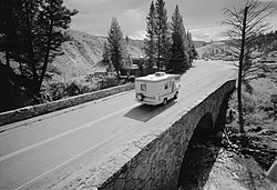
Isa Lake Bridge, Spanning Isa Lake at Grand Loop Road
1577:
Red Lodge-Cooke City Approach Road Historic District
3256:
3143:
3102:
3046:
3000:
2775:
2744:
2694:
2476:
2426:
2164:
2051:
2007:
1826:
1753:
1699:
1590:
1542:
1507:
245:
232:
228:
U.S. Army Corps of Engineers; National Park Service
224:
178:
164:
2622:List of Yellowstone National Park related articles
2685:Historic structures and other attractions in the
1377:at the Wyoming State Historic Preservation Office
3445:Historic American Engineering Record in Wyoming
2372:List of National Historic Landmarks in Wyoming
1957:List of National Historic Landmarks in Wyoming
918:north (West Entrance Road) – Campground,
2962:
2660:
2396:
2314:Snake River Land Company Residence and Office
1981:
1673:
1481:
417:. From the pass, the road descends into the
323:Grand Loop Rd. includes unsigned portions of
8:
3435:Tourist attractions in Teton County, Wyoming
2156:White Grass Ranger Station Historic District
3440:Tourist attractions in Park County, Wyoming
2727:Norris, Madison, and Fishing Bridge Museums
2689:, West Thumb, South and East Entrance areas
2101:Jenny Lake Ranger Station Historic District
2029:Norris, Madison, and Fishing Bridge Museums
1726:Norris, Madison, and Fishing Bridge Museums
1524:Norris, Madison, and Fishing Bridge Museums
2969:
2955:
2947:
2926:Yellowstone National Park-related articles
2921:
2667:
2653:
2645:
2403:
2389:
2381:
1988:
1974:
1966:
1680:
1666:
1658:
1488:
1474:
1466:
785:
656:over Fishing Bridge and continues east to
401:, the road travels south, passing through
100:
2131:Old Administrative Area Historic District
80:U.S. National Register of Historic Places
2234:Jackson Hole American Legion Post No. 43
3425:Transportation in Teton County, Wyoming
2324:St. John's Episcopal Church and Rectory
2096:Hunter Hereford Ranch Historic District
1250:
147:
122:
3430:Transportation in Park County, Wyoming
1259:"National Register Information System"
1123:east (Northeast Entrance Road) –
63:
2244:Jenny Lake Boat Concession Facilities
2199:Double Diamond Dude Ranch Dining Hall
2076:Andy Chambers Ranch Historic District
1803:North Entrance Road Historic District
1798:Mammoth Hot Springs Historic District
1615:Mammoth Hot Springs Historic District
1567:North Entrance Road Historic District
1229:North Entrance Road Historic District
1224:Mammoth Hot Springs Historic District
1173:) – Visitor Center, Campground,
1146:
1106:
1100:
1030:
957:
942:
936:
869:
860:Stretch of road closed December–April
849:) – Visitor Center, Campground,
822:
7:
2931:
2722:Lake Fish Hatchery Historic District
2627:
2111:Lake Fish Hatchery Historic District
1997:National Register of Historic Places
1894:Norris Museum/Norris Comfort Station
1689:National Register of Historic Places
1620:Norris Museum/Norris Comfort Station
1557:Lake Fish Hatchery Historic District
1497:National Register of Historic Places
1381:Historic American Engineering Record
1287:National Register of Historic Places
1264:National Register of Historic Places
1219:Lake Fish Hatchery Historic District
608:Lake Fish Hatchery Historic District
2633:Nature of Yellowstone National Park
1283:"Grand Loop Road Historic District"
998:south (South Entrance Road) –
483:. At this point—Madison Junction (
391:Grand Loop Road-Mammoth Hot Springs
2414:- Tower-Roosevelt and Lamar Valley
2141:Rosencrans Cabin Historic District
800:
14:
2454:Roosevelt Lodge Historic District
2344:Upper Granite Canyon Patrol Cabin
2224:Huckleberry Mountain Fire Lookout
1813:Roosevelt Lodge Historic District
1582:Roosevelt Lodge Historic District
1368:Grand Loop Road Historic District
1234:Roosevelt Lodge Historic District
1071:east (East Entrance Road) –
610:. Just past the Lake Hotel area (
351:Beginning at the junction of the
212:Grand Loop Road Historic District
3388:
2930:
2920:
2735:
2626:
2467:
2042:
1869:First National Bank of Meeteetse
1744:
1716:Heart Mountain Relocation Center
1160:
1154:
1114:
1108:
1054:
1048:
1042:
1037:
981:
975:
969:
964:
901:
895:
889:
883:
877:
836:
830:
515:Grand Loop Road-Madison Junction
146:
139:
121:
114:
2529:Grand Canyon of the Yellowstone
2214:George Washington Memorial Park
1939:US Post Office–Yellowstone Main
1773:Downtown Cody Historic District
1635:US Post Office–Yellowstone Main
1388:Yellowstone Roads & Bridges
1137:Western terminus of US 212
670:Grand Canyon of the Yellowstone
461:Grand Loop Road-Norris Junction
405:on a viaduct and ascending the
288:Grand Canyon of the Yellowstone
2788:Buffalo Bill Cody Scenic Byway
2319:Squirrel Meadows Guard Station
2264:Leigh Lake Ranger Patrol Cabin
2136:Old Faithful Historic District
1572:Old Faithful Historic District
1239:Old Faithful Historic District
1086:Stretch of road closed winters
1021:Stretch of road closed winters
758:Grand Loop Road-Tower Junction
535:Old Faithful Historic District
234:
1:
2284:Grace and Robert Miller Ranch
2189:Chapel of the Transfiguration
2024:Murie Ranch Historic District
795:
471:). Here, the road meets the
155:Show map of the United States
2126:Mormon Row Historic District
855:CW end of US 89 overlap
61:United States historic place
2329:String Lake Comfort Station
2239:Jackson Lake Ranger Station
2091:Highlands Historic District
1914:Ralston Community Clubhouse
1331:"Overview of Grand Loop Rd"
51:GPX (secondary coordinates)
3476:
2449:Northeast Entrance Station
2304:Queen's Laundry Bath House
1934:US Post Office–Powell Main
1808:Red Star Lodge and Sawmill
1630:Queen's Laundry Bath House
585:Grand Loop Road-West Thumb
269:US Army Corps of Engineers
3384:
2988:
2916:
2733:
2683:
2676:Yellowstone National Park
2617:
2465:
2419:
2412:Yellowstone National Park
2362:
2309:Ramshorn Dude Ranch Lodge
2040:
1947:
1841:Buffalo Bill Boyhood Home
1742:
1643:
1501:Yellowstone National Park
1183:
1149:
1141:
1136:
1103:
1095:
1090:
1085:
1033:
1025:
1020:
960:
952:
947:
939:
933:
928:
872:
864:
859:
825:
817:
812:
807:
804:
799:
794:
791:
788:
714:). The road then crosses
597:Grand Teton National Park
527:West Yellowstone, Montana
359:near Mammoth Hot Springs
261:Yellowstone National Park
233:NRHP reference
169:Yellowstone National Park
108:
99:
95:
86:
77:
70:
66:
46:GPX (primary coordinates)
21:Map all coordinates using
2349:Van Vleck House and Barn
2249:Jenny Lake CCC Camp NP-4
1852:Buffalo Bill - The Scout
1363:. National Park Service.
1190:
29:Download coordinates as:
2745:West Thumb Geyser Basin
1763:Absaroka Mountain Lodge
954:West Thumb Geyser Basin
273:Upper, Midway and Lower
2695:Structures and history
2574:Slough Creek (Wyoming)
2427:Structures and history
2294:Moran Bay Patrol Cabin
2151:White Grass Dude Ranch
1929:T E Ranch Headquarters
1456:HAER No. WY-55, "
1449:HAER No. WY-48, "
1442:HAER No. WY-47, "
1435:HAER No. WY-34, "
1428:HAER No. WY-33, "
1421:HAER No. WY-32, "
1414:HAER No. WY-31, "
1407:HAER No. WY-30, "
1400:HAER No. WY-29, "
1393:HAER No. WY-28, "
1386:HAER No. WY-24, "
747:44.91583°N 110.41556°W
704:Grand Loop Road-Canyon
693:44.73583°N 110.49306°W
668:near the mouth of the
631:44.56694°N 110.38639°W
574:44.41361°N 110.57833°W
504:44.64528°N 110.85806°W
450:44.72722°N 110.69639°W
380:44.97611°N 110.70056°W
201:44.63778°N 110.61500°W
89:U.S. Historic district
2823:Heart River (Wyoming)
2776:Geography and geology
2702:Fishing Bridge Museum
2477:Geography and geology
2229:Huff Memorial Library
2001:Teton County, Wyoming
1736:Wapiti Ranger Station
1600:Fishing Bridge Museum
1269:National Park Service
541:the road crosses the
41:GPX (all coordinates)
3125:Powder River Country
2803:Eagle Peak (Wyoming)
2635:at Wikimedia Commons
2599:Trout Lake (Wyoming)
2569:Silver Gate, Montana
2289:Moose Entrance Kiosk
1899:Obsidian Cliff Kiosk
1864:Dead Indian Campsite
1693:Park County, Wyoming
1625:Obsidian Cliff Kiosk
752:44.91583; -110.41556
726:and Tower Junction (
698:44.73583; -110.49306
642:Grand Loop Road-Lake
636:44.56694; -110.38639
579:44.41361; -110.57833
509:44.64528; -110.85806
455:44.72722; -110.69639
385:44.97611; -110.70056
206:44.63778; -110.61500
2878:Orange Mound Spring
2678:– lake and environs
2499:Cooke City, Montana
2444:Lamar Buffalo Ranch
2184:Cascade Canyon Barn
2061:4 Lazy F Dude Ranch
1836:Quintin Blair House
1793:Lamar Buffalo Ranch
1778:Elephant Head Lodge
1562:Lamar Buffalo Ranch
1171:North Entrance Road
1143:Mammoth Hot Springs
847:North Entrance Road
819:Mammoth Hot Springs
770:Cooke City, Montana
742: /
688: /
626: /
569: /
499: /
445: /
375: /
353:North Entrance Road
303:North Entrance Road
299:Mammoth Hot Springs
280:Mammoth Hot Springs
265:Hiram M. Chittenden
196: /
130:Show map of Wyoming
3395:Wyoming portal
2334:T. A. Moulton Barn
2071:Bar B C Dude Ranch
2053:Historic districts
2019:Jackson Lake Lodge
1874:Hayden Arch Bridge
1755:Historic districts
1544:Historic districts
1373:2011-06-15 at the
1125:Northeast Entrance
543:Continental Divide
403:Golden Gate Canyon
318:historic districts
311:Lake Fish Hatchery
3402:
3401:
2944:
2943:
2908:Yellowstone River
2642:
2641:
2631:Media related to
2609:Yellowstone River
2604:Yellowstone Falls
2559:Overhanging Cliff
2494:Beartooth Highway
2378:
2377:
2194:Death Canyon Barn
2146:Snake River Ranch
2009:National Historic
1963:
1962:
1701:National Historic
1655:
1654:
1509:National Historic
1313:"Yellowstone Net"
1271:. April 15, 2008.
1205:
1204:
767:
713:
666:Yellowstone Falls
654:Yellowstone River
651:
594:
524:
470:
400:
253:
252:
249:December 23, 2003
3467:
3393:
3392:
3391:
2971:
2964:
2957:
2948:
2934:
2933:
2924:
2923:
2903:Yellowstone Lake
2848:Mount Chittenden
2828:Jackson, Wyoming
2739:
2687:Yellowstone Lake
2669:
2662:
2655:
2646:
2630:
2629:
2579:Soda Butte Creek
2471:
2459:Yanceys, Wyoming
2405:
2398:
2391:
2382:
2204:Flat Creek Ranch
2166:Other properties
2081:Cunningham Cabin
2046:
2034:Old Faithful Inn
1990:
1983:
1976:
1967:
1924:Paul Stock House
1846:Buffalo Bill Dam
1828:Other properties
1783:Goff Creek Lodge
1748:
1711:Fort Yellowstone
1682:
1675:
1668:
1659:
1592:Other properties
1534:Old Faithful Inn
1519:Fort Yellowstone
1490:
1483:
1476:
1467:
1364:
1347:
1346:
1344:
1342:
1327:
1321:
1320:
1319:on May 13, 2008.
1315:. Archived from
1309:
1303:
1302:
1300:
1298:
1293:on June 15, 2011
1279:
1273:
1272:
1255:
1214:Fort Yellowstone
1198:
1191:
1165:
1164:
1163:
1158:
1157:
1119:
1118:
1117:
1112:
1111:
1059:
1058:
1057:
1052:
1051:
1046:
1045:
1041:
1040:
986:
985:
984:
979:
978:
973:
972:
968:
967:
920:West Yellowstone
906:
905:
904:
899:
898:
893:
892:
888:
887:
886:
881:
880:
866:Madison Junction
841:
840:
839:
834:
833:
802:
797:
786:
766:
765:
763:
762:
761:
759:
754:
753:
748:
743:
740:
739:
738:
735:
727:
722:and descends to
712:
711:
709:
708:
707:
705:
700:
699:
694:
689:
686:
685:
684:
681:
673:
650:
649:
647:
646:
645:
643:
638:
637:
632:
627:
624:
623:
622:
619:
611:
593:
592:
590:
589:
588:
586:
581:
580:
575:
570:
567:
566:
565:
562:
554:
551:Yellowstone Lake
523:
522:
520:
519:
518:
516:
511:
510:
505:
500:
497:
496:
495:
492:
484:
469:
468:
466:
465:
464:
462:
457:
456:
451:
446:
443:
442:
441:
438:
430:
423:Sheepeater Cliff
399:
398:
396:
395:
394:
392:
387:
386:
381:
376:
373:
372:
371:
368:
360:
357:Fort Yellowstone
292:Yellowstone Lake
236:
220:
219:
217:
216:
215:
213:
208:
207:
202:
197:
194:
193:
192:
189:
156:
150:
149:
143:
131:
125:
124:
118:
104:
64:
3475:
3474:
3470:
3469:
3468:
3466:
3465:
3464:
3405:
3404:
3403:
3398:
3389:
3387:
3380:
3252:
3139:
3098:
3042:
2996:
2984:
2975:
2945:
2940:
2912:
2873:Mount Stevenson
2771:
2740:
2731:
2707:Grand Loop Road
2690:
2679:
2673:
2643:
2638:
2613:
2489:Barronette Peak
2472:
2463:
2434:Grand Loop Road
2422:
2415:
2409:
2379:
2374:
2358:
2339:Triangle X Barn
2299:Murie Residence
2209:Gap Puche Cabin
2179:The Brinkerhoff
2160:
2047:
2038:
2010:
2003:
1994:
1964:
1959:
1943:
1822:
1788:Grand Loop Road
1749:
1740:
1702:
1695:
1686:
1656:
1651:
1639:
1586:
1552:Grand Loop Road
1538:
1510:
1503:
1494:
1375:Wayback Machine
1359:
1356:
1351:
1350:
1340:
1338:
1329:
1328:
1324:
1311:
1310:
1306:
1296:
1294:
1281:
1280:
1276:
1257:
1256:
1252:
1247:
1210:
1201:
1193:
1189:
1185:
1161:
1159:
1155:
1153:
1115:
1113:
1109:
1107:
1055:
1053:
1049:
1047:
1043:
1038:
982:
980:
976:
974:
970:
965:
902:
900:
896:
894:
890:
884:
882:
878:
876:
837:
835:
831:
829:
781:
779:Major junctions
757:
755:
751:
749:
745:
744:
741:
736:
733:
731:
729:
728:
703:
701:
697:
695:
691:
690:
687:
682:
679:
677:
675:
674:
664:and past upper
641:
639:
635:
633:
629:
628:
625:
620:
617:
615:
613:
612:
584:
582:
578:
576:
572:
571:
568:
563:
560:
558:
556:
555:
514:
512:
508:
506:
502:
501:
498:
493:
490:
488:
486:
485:
460:
458:
454:
452:
448:
447:
444:
439:
436:
434:
432:
431:
390:
388:
384:
382:
378:
377:
374:
369:
366:
364:
362:
361:
349:
341:Harry W. Frantz
307:Roosevelt Lodge
257:Grand Loop Road
211:
209:
205:
203:
199:
198:
195:
190:
187:
185:
183:
182:
160:
159:
158:
157:
154:
153:
152:
151:
134:
133:
132:
129:
128:
127:
126:
91:
82:
73:
72:Grand Loop Road
62:
59:
58:
57:
56:
55:
12:
11:
5:
3473:
3471:
3463:
3462:
3457:
3452:
3447:
3442:
3437:
3432:
3427:
3422:
3417:
3407:
3406:
3400:
3399:
3385:
3382:
3381:
3379:
3378:
3373:
3368:
3363:
3358:
3353:
3348:
3343:
3338:
3333:
3328:
3323:
3318:
3313:
3308:
3303:
3298:
3293:
3288:
3283:
3278:
3273:
3268:
3262:
3260:
3254:
3253:
3251:
3250:
3245:
3240:
3235:
3230:
3225:
3220:
3215:
3210:
3205:
3200:
3195:
3190:
3185:
3180:
3175:
3170:
3165:
3160:
3155:
3149:
3147:
3141:
3140:
3138:
3137:
3132:
3127:
3122:
3117:
3112:
3106:
3104:
3100:
3099:
3097:
3096:
3091:
3086:
3081:
3076:
3071:
3066:
3061:
3059:Climate change
3056:
3050:
3048:
3044:
3043:
3041:
3040:
3038:Radio stations
3035:
3030:
3025:
3020:
3015:
3010:
3004:
3002:
2998:
2997:
2989:
2986:
2985:
2976:
2974:
2973:
2966:
2959:
2951:
2942:
2941:
2939:
2938:
2928:
2917:
2914:
2913:
2911:
2910:
2905:
2900:
2895:
2893:Sulphur Spring
2890:
2885:
2880:
2875:
2870:
2868:Mount Sheridan
2865:
2860:
2855:
2850:
2845:
2840:
2835:
2830:
2825:
2820:
2815:
2810:
2805:
2800:
2795:
2790:
2785:
2779:
2777:
2773:
2772:
2770:
2769:
2764:
2759:
2754:
2748:
2746:
2742:
2741:
2734:
2732:
2730:
2729:
2724:
2719:
2714:
2709:
2704:
2698:
2696:
2692:
2691:
2684:
2681:
2680:
2674:
2672:
2671:
2664:
2657:
2649:
2640:
2639:
2637:
2636:
2624:
2618:
2615:
2614:
2612:
2611:
2606:
2601:
2596:
2591:
2586:
2584:Specimen Ridge
2581:
2576:
2571:
2566:
2561:
2556:
2554:Mount Washburn
2551:
2546:
2544:Mount Hornaday
2541:
2536:
2531:
2526:
2521:
2516:
2511:
2506:
2501:
2496:
2491:
2486:
2480:
2478:
2474:
2473:
2466:
2464:
2462:
2461:
2456:
2451:
2446:
2441:
2439:John F. Yancey
2436:
2430:
2428:
2424:
2423:
2420:
2417:
2416:
2410:
2408:
2407:
2400:
2393:
2385:
2376:
2375:
2363:
2360:
2359:
2357:
2356:
2351:
2346:
2341:
2336:
2331:
2326:
2321:
2316:
2311:
2306:
2301:
2296:
2291:
2286:
2281:
2276:
2271:
2269:Madison Museum
2266:
2261:
2256:
2251:
2246:
2241:
2236:
2231:
2226:
2221:
2219:Hardeman Barns
2216:
2211:
2206:
2201:
2196:
2191:
2186:
2181:
2176:
2174:Alpenhof Lodge
2170:
2168:
2162:
2161:
2159:
2158:
2153:
2148:
2143:
2138:
2133:
2128:
2123:
2118:
2113:
2108:
2103:
2098:
2093:
2088:
2083:
2078:
2073:
2068:
2063:
2057:
2055:
2049:
2048:
2041:
2039:
2037:
2036:
2031:
2026:
2021:
2015:
2013:
2005:
2004:
1995:
1993:
1992:
1985:
1978:
1970:
1961:
1960:
1948:
1945:
1944:
1942:
1941:
1936:
1931:
1926:
1921:
1916:
1911:
1909:Pioneer School
1906:
1901:
1896:
1891:
1886:
1884:Madison Museum
1881:
1876:
1871:
1866:
1861:
1856:
1848:
1843:
1838:
1832:
1830:
1824:
1823:
1821:
1820:
1815:
1810:
1805:
1800:
1795:
1790:
1785:
1780:
1775:
1770:
1768:Anderson Lodge
1765:
1759:
1757:
1751:
1750:
1743:
1741:
1739:
1738:
1733:
1731:Obsidian Cliff
1728:
1723:
1718:
1713:
1707:
1705:
1697:
1696:
1687:
1685:
1684:
1677:
1670:
1662:
1653:
1652:
1644:
1641:
1640:
1638:
1637:
1632:
1627:
1622:
1617:
1612:
1610:Madison Museum
1607:
1602:
1596:
1594:
1588:
1587:
1585:
1584:
1579:
1574:
1569:
1564:
1559:
1554:
1548:
1546:
1540:
1539:
1537:
1536:
1531:
1529:Obsidian Cliff
1526:
1521:
1515:
1513:
1505:
1504:
1495:
1493:
1492:
1485:
1478:
1470:
1464:
1463:
1462:
1461:
1454:
1447:
1440:
1433:
1426:
1419:
1412:
1405:
1398:
1391:
1378:
1365:
1355:
1354:External links
1352:
1349:
1348:
1322:
1304:
1274:
1249:
1248:
1246:
1243:
1242:
1241:
1236:
1231:
1226:
1221:
1216:
1209:
1206:
1203:
1202:
1200:
1199:
1186:
1181:
1180:
1177:
1151:
1148:
1145:
1139:
1138:
1135:
1105:
1102:
1099:
1097:Tower Junction
1094:
1088:
1087:
1083:
1082:
1079:
1035:
1032:
1029:
1027:Fishing Bridge
1023:
1022:
1018:
1017:
1014:
962:
959:
956:
950:
949:
946:
941:
938:
935:
932:
926:
925:
922:
874:
871:
868:
862:
861:
857:
856:
853:
827:
824:
821:
816:
810:
809:
806:
803:
798:
793:
790:
780:
777:
720:Mount Washburn
553:. West Thumb (
477:Firehole River
427:Obsidian Cliff
407:Gallatin Range
348:
345:
251:
250:
247:
243:
242:
237:
230:
229:
226:
222:
221:
180:
176:
175:
166:
162:
161:
145:
144:
138:
137:
136:
135:
120:
119:
113:
112:
111:
110:
109:
106:
105:
97:
96:
93:
92:
87:
84:
83:
78:
75:
74:
71:
68:
67:
60:
54:
53:
48:
43:
38:
32:
26:
19:
18:
17:
13:
10:
9:
6:
4:
3:
2:
3472:
3461:
3458:
3456:
3453:
3451:
3448:
3446:
3443:
3441:
3438:
3436:
3433:
3431:
3428:
3426:
3423:
3421:
3418:
3416:
3413:
3412:
3410:
3397:
3396:
3383:
3377:
3374:
3372:
3369:
3367:
3364:
3362:
3359:
3357:
3354:
3352:
3349:
3347:
3344:
3342:
3339:
3337:
3334:
3332:
3329:
3327:
3324:
3322:
3319:
3317:
3314:
3312:
3309:
3307:
3304:
3302:
3299:
3297:
3294:
3292:
3289:
3287:
3284:
3282:
3279:
3277:
3274:
3272:
3269:
3267:
3264:
3263:
3261:
3259:
3255:
3249:
3246:
3244:
3241:
3239:
3236:
3234:
3231:
3229:
3226:
3224:
3221:
3219:
3216:
3214:
3211:
3209:
3206:
3204:
3201:
3199:
3196:
3194:
3191:
3189:
3186:
3184:
3181:
3179:
3176:
3174:
3171:
3169:
3166:
3164:
3161:
3159:
3156:
3154:
3151:
3150:
3148:
3146:
3142:
3136:
3133:
3131:
3128:
3126:
3123:
3121:
3118:
3116:
3113:
3111:
3108:
3107:
3105:
3101:
3095:
3092:
3090:
3087:
3085:
3082:
3080:
3077:
3075:
3072:
3070:
3067:
3065:
3062:
3060:
3057:
3055:
3052:
3051:
3049:
3045:
3039:
3036:
3034:
3033:State symbols
3031:
3029:
3026:
3024:
3021:
3019:
3016:
3014:
3011:
3009:
3006:
3005:
3003:
2999:
2994:
2993:
2987:
2983:
2979:
2972:
2967:
2965:
2960:
2958:
2953:
2952:
2949:
2937:
2929:
2927:
2919:
2918:
2915:
2909:
2906:
2904:
2901:
2899:
2896:
2894:
2891:
2889:
2886:
2884:
2883:Shoshone Lake
2881:
2879:
2876:
2874:
2871:
2869:
2866:
2864:
2861:
2859:
2858:Mount Hancock
2856:
2854:
2851:
2849:
2846:
2844:
2841:
2839:
2836:
2834:
2831:
2829:
2826:
2824:
2821:
2819:
2816:
2814:
2813:Hayden Valley
2811:
2809:
2806:
2804:
2801:
2799:
2796:
2794:
2793:Cody, Wyoming
2791:
2789:
2786:
2784:
2781:
2780:
2778:
2774:
2768:
2765:
2763:
2760:
2758:
2755:
2753:
2750:
2749:
2747:
2743:
2738:
2728:
2725:
2723:
2720:
2718:
2715:
2713:
2712:Grant Village
2710:
2708:
2705:
2703:
2700:
2699:
2697:
2693:
2688:
2682:
2677:
2670:
2665:
2663:
2658:
2656:
2651:
2650:
2647:
2634:
2625:
2623:
2620:
2619:
2616:
2610:
2607:
2605:
2602:
2600:
2597:
2595:
2592:
2590:
2589:The Thunderer
2587:
2585:
2582:
2580:
2577:
2575:
2572:
2570:
2567:
2565:
2564:Prospect Peak
2562:
2560:
2557:
2555:
2552:
2550:
2547:
2545:
2542:
2540:
2537:
2535:
2532:
2530:
2527:
2525:
2522:
2520:
2519:Dunraven Peak
2517:
2515:
2514:Dunraven Pass
2512:
2510:
2507:
2505:
2502:
2500:
2497:
2495:
2492:
2490:
2487:
2485:
2484:Abiathar Peak
2482:
2481:
2479:
2475:
2470:
2460:
2457:
2455:
2452:
2450:
2447:
2445:
2442:
2440:
2437:
2435:
2432:
2431:
2429:
2425:
2418:
2413:
2406:
2401:
2399:
2394:
2392:
2387:
2386:
2383:
2373:
2369:
2366:
2361:
2355:
2352:
2350:
2347:
2345:
2342:
2340:
2337:
2335:
2332:
2330:
2327:
2325:
2322:
2320:
2317:
2315:
2312:
2310:
2307:
2305:
2302:
2300:
2297:
2295:
2292:
2290:
2287:
2285:
2282:
2280:
2277:
2275:
2272:
2270:
2267:
2265:
2262:
2260:
2257:
2255:
2252:
2250:
2247:
2245:
2242:
2240:
2237:
2235:
2232:
2230:
2227:
2225:
2222:
2220:
2217:
2215:
2212:
2210:
2207:
2205:
2202:
2200:
2197:
2195:
2192:
2190:
2187:
2185:
2182:
2180:
2177:
2175:
2172:
2171:
2169:
2167:
2163:
2157:
2154:
2152:
2149:
2147:
2144:
2142:
2139:
2137:
2134:
2132:
2129:
2127:
2124:
2122:
2121:Menor's Ferry
2119:
2117:
2114:
2112:
2109:
2107:
2106:Kimmel Kabins
2104:
2102:
2099:
2097:
2094:
2092:
2089:
2087:
2084:
2082:
2079:
2077:
2074:
2072:
2069:
2067:
2064:
2062:
2059:
2058:
2056:
2054:
2050:
2045:
2035:
2032:
2030:
2027:
2025:
2022:
2020:
2017:
2016:
2014:
2012:
2006:
2002:
1998:
1991:
1986:
1984:
1979:
1977:
1972:
1971:
1968:
1958:
1954:
1951:
1946:
1940:
1937:
1935:
1932:
1930:
1927:
1925:
1922:
1920:
1917:
1915:
1912:
1910:
1907:
1905:
1904:Pahaska Tepee
1902:
1900:
1897:
1895:
1892:
1890:
1887:
1885:
1882:
1880:
1877:
1875:
1872:
1870:
1867:
1865:
1862:
1860:
1859:Colter's Hell
1857:
1855:
1853:
1849:
1847:
1844:
1842:
1839:
1837:
1834:
1833:
1831:
1829:
1825:
1819:
1816:
1814:
1811:
1809:
1806:
1804:
1801:
1799:
1796:
1794:
1791:
1789:
1786:
1784:
1781:
1779:
1776:
1774:
1771:
1769:
1766:
1764:
1761:
1760:
1758:
1756:
1752:
1747:
1737:
1734:
1732:
1729:
1727:
1724:
1722:
1719:
1717:
1714:
1712:
1709:
1708:
1706:
1704:
1698:
1694:
1690:
1683:
1678:
1676:
1671:
1669:
1664:
1663:
1660:
1650:
1647:
1642:
1636:
1633:
1631:
1628:
1626:
1623:
1621:
1618:
1616:
1613:
1611:
1608:
1606:
1603:
1601:
1598:
1597:
1595:
1593:
1589:
1583:
1580:
1578:
1575:
1573:
1570:
1568:
1565:
1563:
1560:
1558:
1555:
1553:
1550:
1549:
1547:
1545:
1541:
1535:
1532:
1530:
1527:
1525:
1522:
1520:
1517:
1516:
1514:
1512:
1506:
1502:
1498:
1491:
1486:
1484:
1479:
1477:
1472:
1471:
1468:
1459:
1455:
1452:
1448:
1445:
1441:
1438:
1434:
1431:
1427:
1424:
1420:
1417:
1413:
1410:
1406:
1403:
1399:
1396:
1392:
1389:
1385:
1384:
1382:
1379:
1376:
1372:
1369:
1366:
1362:
1358:
1357:
1353:
1341:September 11,
1337:. Google, Inc
1336:
1332:
1326:
1323:
1318:
1314:
1308:
1305:
1292:
1288:
1284:
1278:
1275:
1270:
1266:
1265:
1260:
1254:
1251:
1244:
1240:
1237:
1235:
1232:
1230:
1227:
1225:
1222:
1220:
1217:
1215:
1212:
1211:
1207:
1196:
1188:
1187:
1182:
1176:
1172:
1168:
1144:
1140:
1134:
1130:
1126:
1122:
1098:
1093:
1089:
1084:
1078:
1074:
1070:
1066:
1062:
1028:
1024:
1019:
1013:
1009:
1005:
1001:
1000:Grant Village
997:
993:
989:
955:
951:
945:
931:
927:
921:
917:
913:
909:
867:
863:
858:
852:
848:
844:
820:
815:
811:
787:
784:
778:
776:
773:
771:
764:
725:
721:
717:
716:Dunraven Pass
710:
671:
667:
663:
662:Hayden Valley
659:
658:Cody, Wyoming
655:
648:
609:
605:
600:
598:
591:
552:
548:
544:
540:
536:
530:
528:
521:
482:
481:Madison River
478:
474:
467:
428:
424:
420:
419:Gardner River
416:
412:
408:
404:
397:
358:
354:
346:
344:
342:
338:
334:
330:
326:
321:
319:
316:
312:
308:
304:
300:
295:
293:
289:
285:
281:
277:
274:
270:
266:
262:
258:
248:
246:Added to NRHP
244:
241:
238:
231:
227:
223:
218:
181:
177:
174:
170:
167:
163:
142:
117:
107:
103:
98:
94:
90:
85:
81:
76:
69:
65:
52:
49:
47:
44:
42:
39:
37:
34:
33:
31:
30:
25:
24:OpenStreetMap
22:
16:
3386:
3233:Rock Springs
3069:Demographics
3008:Bibliography
2990:
2863:Mount Schurz
2808:Factory Hill
2767:Fishing Cone
2706:
2549:Mount Norris
2433:
2364:
2279:Miller Cabin
2274:Manges Cabin
2259:Leek's Lodge
2086:Darwin Ranch
1949:
1919:Stock Center
1851:
1787:
1645:
1551:
1339:. Retrieved
1334:
1325:
1317:the original
1307:
1295:. Retrieved
1291:the original
1286:
1277:
1262:
1253:
1192:
944:Old Faithful
910:west /
805:Destinations
782:
774:
601:
539:Old Faithful
531:
479:to form the
473:Gibbon River
411:Kingman Pass
350:
322:
315:Old Faithful
296:
256:
254:
28:
27:
20:
15:
3306:Hot Springs
3188:Green River
3135:Yellowstone
3120:Great Basin
3115:Grand Teton
3110:Black Hills
3089:LGBT rights
3018:Delegations
2898:Sylvan Pass
2888:Snake River
2853:Mount Doane
2843:Lewis River
2833:Lewis Falls
2798:Colter Peak
2783:Barlow Peak
2539:Lamar River
2534:Hedges Peak
2524:Folsom Peak
1721:Horner site
1335:Google Maps
1195:Concurrency
1129:Silver Gate
1121:US 212
1073:Sylvan Pass
1008:Grand Teton
996:US 287
992:US 191
948:Interchange
916:US 287
912:US 191
750: /
737:110°24′56″W
696: /
683:110°29′35″W
634: /
621:110°23′11″W
577: /
564:110°34′42″W
507: /
494:110°51′29″W
453: /
440:110°41′47″W
415:Bunsen Peak
409:, crossing
383: /
204: /
191:110°36′54″W
179:Coordinates
3409:Categories
3356:Sweetwater
3243:Torrington
3130:Red Desert
2838:Lewis Lake
2818:Heart Lake
2762:Black Pool
2752:Abyss Pool
2717:Lake Hotel
2594:Tower Fall
2509:Druid Peak
2354:Wort Hotel
2254:Lake Hotel
1889:Mummy Cave
1879:Irma Hotel
1605:Lake Hotel
1297:August 17,
1245:References
1167:US 89
1133:Cooke City
1069:US 20
1065:US 16
1061:US 14
1004:Lewis Lake
988:US 89
908:US 20
843:US 89
756: (
734:44°54′57″N
724:Tower Fall
702: (
640: (
604:Lake Hotel
583: (
561:44°24′49″N
547:Craig Pass
513: (
491:44°38′43″N
459: (
437:44°43′38″N
389: (
370:110°42′2″W
367:44°58′34″N
284:Tower Fall
210: (
188:44°38′16″N
3213:Newcastle
3079:Education
3013:Governors
2995:(capital)
2504:Cook Peak
2365:See also:
2066:AMK Ranch
2011:Landmarks
1950:See also:
1818:UXU Ranch
1703:Landmarks
1646:See also:
1511:Landmarks
1179:See above
680:44°44′9″N
618:44°34′1″N
225:Architect
3371:Washakie
3351:Sublette
3346:Sheridan
3331:Niobrara
3286:Converse
3276:Campbell
3271:Big Horn
3258:Counties
3238:Sheridan
3228:Riverton
3198:Kemmerer
3183:Gillette
3178:Evanston
3163:Cheyenne
3094:Politics
3084:Gun laws
3054:Abortion
2992:Cheyenne
2757:Big Cone
1371:Archived
1208:See also
1197:terminus
1175:Gardiner
1067: /
1063: /
994: /
990: /
914: /
851:Gardiner
792:Location
606:and the
278:basins,
240:03001345
165:Location
3326:Natrona
3321:Lincoln
3316:Laramie
3311:Johnson
3296:Fremont
3248:Worland
3223:Rawlins
3208:Laramie
3193:Jackson
3173:Douglas
3153:Buffalo
3103:Regions
3074:Economy
3047:Society
3023:History
2982:Wyoming
2936:Commons
1169:north (
1012:Jackson
934:
845:north (
267:of the
173:Wyoming
3376:Weston
3341:Platte
3301:Goshen
3281:Carbon
3266:Albany
3218:Powell
3203:Lander
3158:Casper
3145:Cities
3028:People
3001:Topics
1854:statue
789:County
337:US 287
333:US 191
286:, the
276:geyser
3366:Uinta
3361:Teton
3291:Crook
3064:Crime
2978:State
1150:225.5
1147:140.1
1104:196.3
1101:122.0
1034:142.3
961:109.1
930:Teton
808:Notes
718:near
545:over
413:near
347:Route
329:US 89
325:US 20
3336:Park
3168:Cody
2370:and
1955:and
1343:2016
1299:2010
1092:Park
1077:Cody
1031:88.4
958:67.8
940:80.8
937:50.2
873:55.2
870:34.3
814:Park
335:and
313:and
290:and
255:The
2980:of
1999:in
1691:in
1499:in
826:0.0
823:0.0
235:No.
36:KML
3411::
1333:.
1285:.
1267:.
1261:.
1131:,
1127:,
1075:,
1010:,
1006:,
1002:,
801:km
796:mi
772:.
599:.
529:.
331:,
327:,
320:.
309:,
305:,
301:,
294:.
282:,
171:,
2970:e
2963:t
2956:v
2668:e
2661:t
2654:v
2404:e
2397:t
2390:v
1989:e
1982:t
1975:v
1681:e
1674:t
1667:v
1489:e
1482:t
1475:v
1345:.
1301:.
760:)
706:)
672:(
644:)
587:)
517:)
463:)
393:)
214:)
Text is available under the Creative Commons Attribution-ShareAlike License. Additional terms may apply.