340:
425:, causing the valley to no longer be connected by difficult wagon roads. As one pioneer woman in the area wrote, "No more big, heavily loaded freight wagons with their wheels buried to the hub in mud." Two routes were proposed to exit the valley eastward, one that would put the railroad close to Union, and one that would put it close to La Grande. Both towns wanted the railroad, so a competition developed with both towns trying to please the engineers sent to survey the routes. Eventually the La Grande route was chosen. The railroad was completed in 1884.
164:
328:. In 1862, Conrad Miller settled the opposite side of the valley. This settlement grew into the city of Union, the second largest community in the Grande Ronde Valley. Island City, Cove, and Summerville were not far behind. Many factors contributed to the growth of the valley. Some of these were the continuing presence of emigrants from the Oregon Trail, and the discovery of
26:
1010:
303:
would pass through it. Every traveler who left a record of passing through the area was left with a favorable impression. Early pioneers chose not to settle in the valley, perhaps because they were intent upon reaching the
Willamette Valley, it was too far from a supply base, or they feared the
370:, who set up businesses in the area. Mormons followed and settled in the valley after then, and remained a prominent force until the Nibley-Stoddard mills were purchased or closed between 1920 and 1931. The influence of the Mormons in the area was limited, as all profits were sent to
283:, would spend their summers in the bountiful Grande Ronde Valley. Here they would forage, hunt, fish, and bathe in hot springs. Tribes that may have been hostile toward each other would live together harmoniously in the "Valley of Peace".
304:
Native
Americans in the area. The first permanent settlement in the Grande Ronde Valley was not established until 1861. The first permanent settler in the Grande Ronde Valley was Benjamin Brown, an Englishman who had originally settled in
308:. Not long after, the Leasey family and about 20 others settled there. Serving as a travelers inn, the settlement was originally named Brown's Fort, and then Browns Town or Brownsville. Since there was already a Brownsville in
394:. The Grande Ronde and Walla Walla route was to be 80 miles (130 km) long but was never completed, and the connection from Walla Walla to the Columbia River covered 33 miles (53 km) and took six years to complete.
478:
Old Oregon Trail
Highway (South) (Interstate 84): Going this direction, the highway comes back out on the south end of the valley through Ladd Canyon. It passes into Powder Valley and continues toward
211:
is to the southeast. The highest nearby mountains are Mount Fanny to the east, with an elevation of 7,136 feet (2,175 m); Mount Harris to the northeast, elevation 5,335 feet (1,626 m); and
405:. They organized a company, called the Columbia River and Blue Mountain Railroad Company, and sent teams to Umatilla to begin grading. In 1879, the whole enterprise was surrendered to
151:
is its largest community. The valley is 35 miles (56 km) long, north to south, from
Pumpkin Ridge to Pyles Canyon, and 15 miles (24 km) wide, east to west, from
561:
820:
1066:
670:
635:
391:
490:): This highway exits on the other side of the Grande Ronde River canyon in the north and enters Indian Valley. It then continues and ends at
195:. The Grande Ronde Valley floor began to sink from this plateau at a rate of about .07-.18 millimeters per year about nine million years ago.
410:
260:
661:
626:
867:
348:
212:
172:
919:
383:
666:
631:
565:
339:
713:
1022:
1014:
591:
569:
771:
985:
1061:
467:): This highway leaves on the west side of the valley through the Grande Ronde River canyon. It goes through the
359:
203:
The Grande Ronde Valley floor is at about 2,700 feet (820 m) above sea level. Its horizon is dominated by the
911:
859:
824:
595:
656:
621:
854:
521:
506:
468:
436:
204:
136:
105:
440:
180:
163:
502:
464:
397:
In 1878, several La Grande residents spearheaded an effort to build a railroad from La Grande to the
387:
208:
128:
87:
31:
448:
309:
232:
224:
444:
767:
480:
422:
324:
northern parts of the valley, as the southern end was subject to flooding, swampy, and contained
276:
144:
691:
915:
863:
849:
845:
775:
472:
414:
363:
344:
300:
228:
168:
148:
140:
115:
215:
to the northwest, elevation 6,110 feet (1,860 m). Communities within the valley include
536:
528:
513:
498:
402:
292:
264:
517:
487:
367:
280:
272:
240:
428:
The Oregon
Railway and Navigation Company (OR&N) built a spur line from La Grande to
797:
540:
398:
256:
220:
1055:
962:
532:
429:
418:
406:
333:
325:
268:
236:
95:
884:
717:
491:
296:
216:
184:
152:
72:
386:
in 1872 by H. J. Mecham and James
Hendershott, as well as an effort to connect to
936:
155:
to the Grande Ronde River's canyon. Its name, fittingly, means, "great circle."
329:
321:
187:
eruptions. These happen when a long crack in the Earth's crust spews floods of
599:
1037:
1024:
432:. When the spur was completed, La Grande citizens paid $ 7,000 to OR&N.
25:
779:
239:. The Grande Ronde River flows through the valley; its tributaries include
1009:
305:
764:
The roles of the railroad in the development of the Grande Ronde Valley
355:
451:. These temporary lines were 4 to 7 miles (6.4 to 11.3 km) long.
435:
The first logging railroads in the valley were built in 1907 for the
192:
132:
91:
413:. The Oregon Railway and Navigation lines were to be joined to the
295:
passed through the valley in 1811, and it was a waypoint along the
338:
162:
459:
There are six ways to get in and out of the Grande Ronde Valley.
371:
188:
798:"First Settlement in Grande Ronde Valley, Union County, Oregon"
501:): This highway exits the valley through Pyles Canyon. Past
358:
were attracted to the valley after an 1889 business trip by
516:): This highway leaves the valley through the canyon of
692:"Mount Harris Summit – Oregon Mountain Peak Information"
183:. The Columbia River Plateau was created by a series of
562:"Description: Columbia Plateau, Columbia River Basalt"
191:. The molten rock then hardens and creates layers of
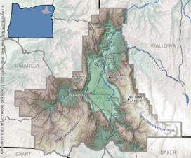
34:, with the Grande Ronde Valley featured in the center.
243:, Fir, Ladd, Little, Mill, Pyles, and Willow creeks.
343:The west end of the Grande Ronde Valley, including
111:
101:
83:
78:
68:
63:
55:
47:
39:
18:
986:"A 1940 Journey Across Oregon: Baker to La Grande"
716:. Union County Chamber of Commerce. Archived from
524:, and then ends on Interstate 84 near Baker City.
531:): This highway leaves the valley, starting at
443:, both owned by Charles W. Nibley with partners
382:Many railroad efforts were begun, including the
299:. Since the 1840s, settlers headed toward the
374:, rather than staying with local businessmen.
259:and the surrounding area was a haven for many
592:"Recent Faculty and Student Geology Research"
384:Grande Ronde and Walla Walla Railroad Company
263:tribes. Many of these tribes, including the
8:
336:in 1861 and the Powder River Mines in 1862.
15:
956:
954:
885:"La Grande History, Union County, Oregon"
135:, United States. It is surrounded by the
671:United States Department of the Interior
636:United States Department of the Interior
167:A barn in the Grande Ronde Valley, near
791:
789:
552:
392:Walla Walla and Columbia River Railroad
179:The Grande Ronde Valley is part of the
332:in the surrounding area, including at
287:First contact and Permanent settlement
937:"Union, Union County, Oregon History"
757:
755:
411:Oregon Railway and Navigation Company
312:, the name was changed to La Grande.
7:
753:
751:
749:
747:
745:
743:
741:
739:
737:
735:
714:"History of the Grande Ronde Valley"
539:. It travels west then and ends at
963:"Railroads in Union County, Oregon"
662:Geographic Names Information System
627:Geographic Names Information System
320:Early settlements were in the more
858:(7th ed.). Portland, Oregon:
463:Old Oregon Trail Highway (North) (
14:
1067:Landforms of Union County, Oregon
505:and Interstate 84, it turns into
1008:
908:Main Street: Northeastern Oregon
24:
762:Deumling, Dietrich (May 1972).
667:United States Geological Survey
632:United States Geological Survey
566:United States Geological Survey
1:
906:Bailey, Barbara Ruth (1982).
509:and continues to Baker City.
988:. Oregon Secretary of State
772:Northern Arizona University
51:35 miles North to South
1083:
43:820 m (2,690 ft)
912:Oregon Historical Society
860:Oregon Historical Society
825:Oregon Historical Society
596:Eastern Oregon University
512:Medical Springs Highway (
497:La Grande-Baker Highway (
23:
984:Halvorson, Gary (2005).
143:, and is drained by the
855:Oregon Geographic Names
1038:45.36278°N 117.95500°W
486:Wallowa Lake Highway (
437:Hilgard Lumber Company
352:
181:Columbia River Plateau
176:
1017:at Wikimedia Commons
821:"Grande Ronde Valley"
622:"Grande Ronde Valley"
441:Mecham Lumber Company
342:
166:
1043:45.36278; -117.95500
535:going north through
209:Eagle Cap Wilderness
1034: /
1015:Grande Ronde Valley
694:. Mountain Zone.com
602:on 22 November 2008
572:on 11 December 2008
560:Topinka, L (2003).
125:Grande Ronde Valley
19:Grande Ronde Valley
965:. Oregon Genealogy
961:Reavis, J (2005).
939:. Oregon Genealogy
935:Reavis, J (2005).
887:. Oregon Genealogy
883:Reavis, J (2005).
850:McArthur, Lewis L.
846:McArthur, Lewis A.
819:Allen, C. (2005).
800:. Oregon Genealogy
796:Reavis, J (2004).
768:Flagstaff, Arizona
353:
177:
175:in the background.
145:Grande Ronde River
1062:Valleys of Oregon
1013:Media related to
720:on 30 August 2011
520:. It travels to
415:Oregon Short Line
364:Charles W. Nibley
301:Willamette Valley
141:Wallowa Mountains
121:
120:
116:Grand Ronde River
30:Elevation map of
1074:
1049:
1048:
1046:
1045:
1044:
1039:
1035:
1032:
1031:
1030:
1027:
1012:
998:
997:
995:
993:
981:
975:
974:
972:
970:
958:
949:
948:
946:
944:
932:
926:
925:
903:
897:
896:
894:
892:
880:
874:
873:
842:
836:
835:
833:
831:
816:
810:
809:
807:
805:
793:
784:
783:
759:
730:
729:
727:
725:
710:
704:
703:
701:
699:
688:
682:
681:
679:
677:
653:
647:
646:
644:
642:
618:
612:
611:
609:
607:
598:. Archived from
588:
582:
581:
579:
577:
568:. Archived from
557:
529:Oregon Route 204
514:Oregon Route 203
499:Oregon Route 237
293:Astor Expedition
252:Native Americans
131:in northeastern
28:
16:
1082:
1081:
1077:
1076:
1075:
1073:
1072:
1071:
1052:
1051:
1042:
1040:
1036:
1033:
1028:
1025:
1023:
1021:
1020:
1006:
1001:
991:
989:
983:
982:
978:
968:
966:
960:
959:
952:
942:
940:
934:
933:
929:
922:
905:
904:
900:
890:
888:
882:
881:
877:
870:
844:
843:
839:
829:
827:
818:
817:
813:
803:
801:
795:
794:
787:
761:
760:
733:
723:
721:
712:
711:
707:
697:
695:
690:
689:
685:
675:
673:
655:
654:
650:
640:
638:
620:
619:
615:
605:
603:
590:
589:
585:
575:
573:
559:
558:
554:
550:
527:Tollgate Road (
522:Medical Springs
518:Catherine Creek
488:Oregon Route 82
457:
388:Dorsey S. Baker
380:
368:George Stoddard
318:
289:
261:Native American
254:
249:
201:
161:
127:is a valley in
40:Floor elevation
35:
12:
11:
5:
1080:
1078:
1070:
1069:
1064:
1054:
1053:
1005:
1004:External links
1002:
1000:
999:
976:
950:
927:
920:
914:. p. 25.
898:
875:
869:978-0875952772
868:
837:
811:
785:
731:
705:
683:
648:
613:
583:
551:
549:
546:
545:
544:
525:
510:
495:
484:
476:
469:Blue Mountains
456:
455:Transportation
453:
449:Merrill Nibley
399:Columbia River
379:
376:
317:
314:
288:
285:
257:Eastern Oregon
253:
250:
248:
245:
205:Blue Mountains
200:
197:
173:Blue Mountains
160:
157:
137:Blue Mountains
119:
118:
113:
109:
108:
106:Blue Mountains
103:
99:
98:
85:
81:
80:
76:
75:
70:
66:
65:
61:
60:
57:
53:
52:
49:
45:
44:
41:
37:
36:
29:
21:
20:
13:
10:
9:
6:
4:
3:
2:
1079:
1068:
1065:
1063:
1060:
1059:
1057:
1050:
1047:
1018:
1016:
1011:
1003:
987:
980:
977:
964:
957:
955:
951:
938:
931:
928:
923:
921:0-87595-073-6
917:
913:
909:
902:
899:
886:
879:
876:
871:
865:
861:
857:
856:
851:
847:
841:
838:
826:
822:
815:
812:
799:
792:
790:
786:
781:
777:
773:
769:
765:
758:
756:
754:
752:
750:
748:
746:
744:
742:
740:
738:
736:
732:
719:
715:
709:
706:
693:
687:
684:
672:
668:
664:
663:
658:
657:"Mount Fanny"
652:
649:
637:
633:
629:
628:
623:
617:
614:
601:
597:
593:
587:
584:
571:
567:
563:
556:
553:
547:
542:
538:
534:
530:
526:
523:
519:
515:
511:
508:
507:U.S. Route 30
504:
500:
496:
493:
489:
485:
482:
477:
474:
470:
466:
465:Interstate 84
462:
461:
460:
454:
452:
450:
446:
442:
438:
433:
431:
426:
424:
420:
419:Union Pacific
416:
412:
408:
407:Henry Villard
404:
400:
395:
393:
389:
385:
377:
375:
373:
369:
365:
361:
357:
350:
346:
341:
337:
335:
331:
327:
326:alkaline soil
323:
315:
313:
311:
307:
302:
298:
294:
286:
284:
282:
278:
274:
270:
266:
262:
258:
251:
246:
244:
242:
238:
234:
230:
226:
222:
218:
214:
210:
206:
198:
196:
194:
190:
186:
182:
174:
170:
165:
158:
156:
154:
150:
146:
142:
138:
134:
130:
126:
117:
114:
110:
107:
104:
100:
97:
96:United States
93:
89:
86:
82:
77:
74:
71:
67:
62:
58:
54:
50:
46:
42:
38:
33:
27:
22:
17:
1019:
1007:
990:. Retrieved
979:
967:. Retrieved
941:. Retrieved
930:
907:
901:
889:. Retrieved
878:
853:
840:
828:. Retrieved
814:
802:. Retrieved
763:
722:. Retrieved
718:the original
708:
696:. Retrieved
686:
674:. Retrieved
660:
651:
639:. Retrieved
625:
616:
604:. Retrieved
600:the original
586:
574:. Retrieved
570:the original
555:
503:North Powder
492:Wallowa Lake
458:
445:J. F. Nibley
434:
427:
396:
381:
360:David Eccles
354:
319:
297:Oregon Trail
290:
255:
202:
185:basalt flood
178:
129:Union County
124:
122:
88:Union County
73:Flood basalt
32:Union County
1041: /
1029:117°57′18″W
349:Mount Emily
310:Linn County
277:Walla Walla
233:Summerville
225:Island City
213:Mount Emily
171:, with the
1056:Categories
1026:45°21′46″N
992:22 October
969:22 October
943:22 October
891:22 October
830:7 December
804:7 December
724:22 October
698:3 December
676:22 October
641:22 October
606:7 December
576:3 December
548:References
481:Baker City
423:Huntington
330:gold mines
102:Borders on
852:(2003) .
473:Pendleton
345:La Grande
265:Nez Perce
241:Catherine
229:La Grande
199:Geography
169:La Grande
149:La Grande
79:Geography
537:Tollgate
409:and his
403:Umatilla
378:Railroad
306:Michigan
281:Shoshone
273:Umatilla
84:Location
59:15 miles
862:Press.
780:4383986
471:toward
356:Mormons
247:History
159:Geology
64:Geology
918:
866:
778:
541:Weston
366:, and
322:arable
316:Growth
279:, and
269:Cayuse
235:, and
221:Imbler
193:basalt
133:Oregon
112:Rivers
92:Oregon
48:Length
533:Elgin
430:Elgin
334:Baker
237:Union
56:Width
994:2011
971:2011
945:2011
916:ISBN
893:2011
864:ISBN
832:2008
806:2008
776:OCLC
726:2011
700:2008
678:2011
643:2011
608:2008
578:2008
447:and
439:and
417:and
372:Utah
347:and
291:The
217:Cove
189:lava
153:Cove
139:and
123:The
69:Type
421:at
401:at
390:'s
1058::
953:^
910:.
848:;
823:.
788:^
774:.
770::
766:.
734:^
669:,
665:.
659:.
634:,
630:.
624:.
594:.
564:.
362:,
275:,
271:,
267:,
231:,
227:,
223:,
219:,
207:.
147:.
94:,
90:,
996:.
973:.
947:.
924:.
895:.
872:.
834:.
808:.
782:.
728:.
702:.
680:.
645:.
610:.
580:.
543:.
494:.
483:.
475:.
351:.
Text is available under the Creative Commons Attribution-ShareAlike License. Additional terms may apply.