Name
Location
Type
Completed Date designated
Grid ref. Entry number Image
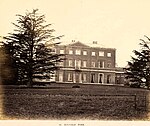
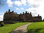
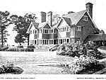
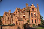
Aldermaston Court
Aldermaston House
1636
14 April 1967 SU5965764807 51°22′45″N 1°08′39″W / 51.379188°N 1.144217°W / 51.379188; -1.144217 (Aldermaston Court ) 1117317 Aldermaston Court
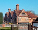
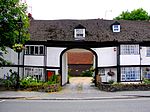
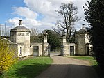
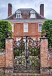
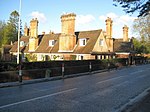
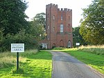
North-east lodges and gates to Aldermaston Court
Aldermaston House
c .163625 October 1951 SU5913665086 51°22′54″N 1°09′06″W / 51.381751°N 1.151656°W / 51.381751; -1.151656 (North-east lodges and gates to Aldermaston Court ) 1117332 North-east lodges and gates to Aldermaston Court
Oxford Lodges to Basildon Park with gates, gatepiers and flanking walls
Basildon Gate
1776–87 19 June 1984 SU6124478495 51°30′07″N 1°07′09″W / 51.502082°N 1.119054°W / 51.502082; -1.119054 (Oxford Lodges to Basildon Park with gates, gatepiers and flanking walls ) 1210340 Oxford Lodges to Basildon Park with gates, gatepiers and flanking walls
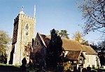
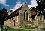
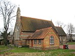
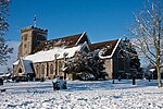
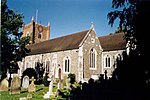
Church of St Mary the Virgin
Beech Hill Parish church
1867
14 April 1967 SU6979764397 51°22′28″N 0°59′55″W / 51.374348°N 0.998625°W / 51.374348; -0.998625 (Church of St Mary the Virgin ) 1117135 Church of St Mary the Virgin
The Priory including adjoining wall on the north-east
Beech Hill Country house
16th century 14 April 1947 SU7081764340 51°22′25″N 0°59′02″W / 51.37371°N 0.983985°W / 51.37371; -0.983985 (The Priory including adjoining wall on the north-east ) 1117130 Upload Photo
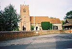
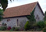
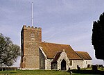
Church of St Mary
Beenham Church
1794
14 April 1967 SU5908068480 51°24′44″N 1°09′07″W / 51.412271°N 1.151896°W / 51.412271; -1.151896 (Church of St Mary ) 1303517 Church of St Mary
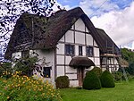
White Cottage
Beenham House
17th century 10 November 1983 SU5972569492 51°25′17″N 1°08′33″W / 51.421302°N 1.142453°W / 51.421302; -1.142453 (White Cottage ) 1117296 White Cottage
Parish Church of St Andrew
Boxford Parish church
13th century 6 April 1967 SU4287171632 51°26′31″N 1°23′04″W / 51.442065°N 1.384563°W / 51.442065; -1.384563 (Parish Church of St Andrew ) 1219764 Parish Church of St Andrew
Bradfield Hall, adjoining kitchen block and adjoining garden wall
Rotten Row, Bradfield
House
c .170025 October 1951 SU5886371603 51°26′25″N 1°09′16″W / 51.440371°N 1.154498°W / 51.440371; -1.154498 (Bradfield Hall, adjoining kitchen block and adjoining garden wall ) 1289492 Upload Photo
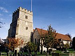
Church of St Andrew
Bradfield Church
16th century 14 April 1967 SU6033272580 51°26′56″N 1°08′00″W / 51.449001°N 1.133199°W / 51.449001; -1.133199 (Church of St Andrew ) 1289580 Church of St Andrew
Chapel approximately 10m east of Manor Farmhouse
Brimpton Chapel
c .11006 April 1967 SU5582265272 51°23′02″N 1°11′57″W / 51.383758°N 1.199241°W / 51.383758; -1.199241 (Chapel approximately 10m east of Manor Farmhouse ) 1303413 Chapel approximately 10m east of Manor Farmhouse
Church of St Mary
Marlston , Bucklebury Church
12th century 7 December 1971 SU5290971967 51°26′39″N 1°14′24″W / 51.44423°N 1.240099°W / 51.44423; -1.240099 (Church of St Mary ) 1212896 Church of St Mary
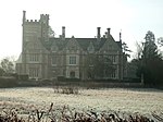
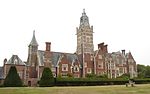
Marlston House and surrounding terrace
Marlston , Bucklebury House
1895–99 29 November 1983 SU5299071882 51°26′36″N 1°14′20″W / 51.443459°N 1.238946°W / 51.443459; -1.238946 (Marlston House and surrounding terrace ) 1212898 Marlston House and surrounding terrace
The Old Vicarage
Bucklebury House
Early 18th century 25 October 1951 SU5533870868 51°26′03″N 1°12′19″W / 51.434118°N 1.205323°W / 51.434118; -1.205323 (The Old Vicarage ) 1212777 Upload Photo
Garston Lock at SU656708
Kennet and Avon Canal , Burghfield Lock
Early 18th century 6 December 1990 SU6558270746 51°25′55″N 1°03′29″W / 51.43193°N 1.058°W / 51.43193; -1.058 (Garston Lock at SU656708 ) 1117125 Garston Lock at SU656708
The Old Rectory
Burghfield Country house
Late 16th century 25 October 1951 SU6659168593 51°24′45″N 1°02′38″W / 51.412456°N 1.043892°W / 51.412456; -1.043892 (The Old Rectory ) 1135782 Upload Photo
Catmore Farm House
Catmore Farmhouse
14th century 21 October 1951 SU4536380168 51°31′07″N 1°20′51″W / 51.518618°N 1.347617°W / 51.518618; -1.347617 (Catmore Farm House ) 1210996 Catmore Farm House
Barn with corn mill and attached stable forming north-east side of former farmyard at Woolley House
Woolley Park, Chaddleworth
Corn mill
Probably Early 19th century
5 November 1990 SU4106080134 51°31′07″N 1°24′35″W / 51.518641°N 1.409632°W / 51.518641; -1.409632 (Barn with corn mill and attached stable forming north-east side of former farmyard at Woolley House ) 1290292 Upload Photo
Woolley Park
Woolley Park, Chaddleworth
Country house
Late 17th century 25 October 1951 SU4101480060 51°31′05″N 1°24′37″W / 51.517979°N 1.410304°W / 51.517979; -1.410304 (Woolley Park ) 1290345 Woolley Park
Chieveley House
Chieveley House
18th century 6 April 1967 SU4759273984 51°27′46″N 1°18′59″W / 51.462836°N 1.316326°W / 51.462836; -1.316326 (Chieveley House ) 1291142 Chieveley House
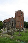
Church of St Mary
Chieveley Church
13th century 6 April 1967 SU4744474096 51°27′50″N 1°19′06″W / 51.463855°N 1.318442°W / 51.463855; -1.318442 (Church of St Mary ) 1220107 Church of St Mary
Prior's Court School
Chieveley House
Late 18th century 6 April 1967 SU4883473677 51°27′36″N 1°17′55″W / 51.45997°N 1.298492°W / 51.45997; -1.298492 (Prior's Court School ) 1291103 Prior's Court School
Garden house at Manor Farm in south-west corner of garden wall
Combe Garden house
c .167010 September 1951 SU3673860697 51°20′39″N 1°28′26″W / 51.344176°N 1.473928°W / 51.344176; -1.473928 (Garden house at Manor Farm in south-west corner of garden wall ) 1290619 Garden house at Manor Farm in south-west corner of garden wall
Wrights Farm House
Combe Farmhouse
14th century 8 June 1984 SU3666761465 51°21′04″N 1°28′30″W / 51.351086°N 1.474869°W / 51.351086; -1.474869 (Wrights Farm House ) 1221121 Wrights Farm House
Church of St Mary and St Nicholas
Compton Church
18th century 24 November 1966 SU5262579670 51°30′49″N 1°14′35″W / 51.513512°N 1.243039°W / 51.513512; -1.243039 (Church of St Mary and St Nicholas ) 1135775 Church of St Mary and St Nicholas
Church of All Saints
East Garston Church
12th century 6 February 1982 SU3612277068 51°29′29″N 1°28′52″W / 51.49141°N 1.481109°W / 51.49141; -1.481109 (Church of All Saints ) 1321874 Church of All Saints
Mask Cottage
East Garston House
18th century 11 July 1983 SU3667276542 51°29′12″N 1°28′24″W / 51.486646°N 1.473242°W / 51.486646; -1.473242 (Mask Cottage ) 1321873 Upload Photo
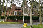
Kennet House
East Ilsley House
Early 18th century 25 October 1951 SU4929281024 51°31′34″N 1°17′27″W / 51.525986°N 1.290877°W / 51.525986; -1.290877 (Kennet House ) 1319564 Kennet House
Englefield House and entrance courtyard adjoining to north-east
Englefield House
1590–1600 19 June 1984 SU6222871943 51°26′35″N 1°06′22″W / 51.443069°N 1.106031°W / 51.443069; -1.106031 (Englefield House and entrance courtyard adjoining to north-east ) 1289194 Englefield House and entrance courtyard adjoining to north-east
Fawley Manor House
South Fawley Manor house
c .160025 October 1951 SU3914780105 51°31′07″N 1°26′14″W / 51.518515°N 1.437204°W / 51.518515; -1.437204 (Fawley Manor House ) 1210771 Fawley Manor House
Church of St Frideswide
Frilsham Church
12th century 29 November 1983 SU5380473195 51°27′19″N 1°13′37″W / 51.455187°N 1.227036°W / 51.455187; -1.227036 (Church of St Frideswide ) 1213105 Church of St Frideswide
Church of St Mary
Great Shefford Church
19th century 6 February 1962 SU3801775375 51°28′34″N 1°27′14″W / 51.476065°N 1.453997°W / 51.476065; -1.453997 (Church of St Mary ) 1113644 Church of St Mary
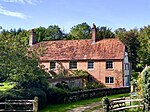
Manor Farmhouse
Great Shefford Farmhouse
16th century 10 September 1951 SU3802075326 51°28′32″N 1°27′14″W / 51.475624°N 1.453959°W / 51.475624; -1.453959 (Manor Farmhouse ) 1113648 Upload Photo
Church of St Mary
Greenham Church
1875–76 6 April 1967 SU4859865711 51°23′18″N 1°18′11″W / 51.388369°N 1.302979°W / 51.388369; -1.302979 (Church of St Mary ) 1291027 Church of St Mary
Greenham Lodge
Greenham Apartment
1969
9 September 1969 SU4898765615 51°23′15″N 1°17′51″W / 51.387472°N 1.297402°W / 51.387472; -1.297402 (Greenham Lodge ) 1291019 Greenham Lodge
Building 50 metres north-west of Morewood House
Hampstead Marshall Orangery
c .1705–186 April 1967 SU4159166724 51°23′53″N 1°24′13″W / 51.398032°N 1.403553°W / 51.398032; -1.403553 (Building 50 metres north-west of Morewood House ) 1136066 Upload Photo
Church of St Mary
Hampstead Marshall Church
14th century 6 May 1967 SU4200066746 51°23′54″N 1°23′52″W / 51.3982°N 1.397671°W / 51.3982; -1.397671 (Church of St Mary ) 1117223 Church of St Mary
Pair of gate piers and approximately 2 metres of wall to east and west of piers on edge of Park Lane 162 metres west of entrance to churchyard
Hampstead Marshall Gate pier
Early 18th century 6 March 1985 SU4180966703 51°23′52″N 1°24′02″W / 51.397827°N 1.400422°W / 51.397827; -1.400422 (Pair of gate piers and approximately 2 metres of wall to east and west of piers on edge of Park Lane 162 metres west of entrance to churchyard ) 1117222 Pair of gate piers and approximately 2 metres of wall to east and west of piers on edge of Park Lane 162 metres west of entrance to churchyard
Lowsley Tomb, approximately 3 metres south of south wall of Church of St Mary
Hampstead Norreys Tomb
Late 19th century 5 June 1986 SU5293676246 51°28′58″N 1°14′21″W / 51.482699°N 1.239071°W / 51.482699; -1.239071 (Lowsley Tomb, approximately 3 metres south of south wall of Church of St Mary ) 1117158 Lowsley Tomb, approximately 3 metres south of south wall of Church of St Mary
Holybrook Cottage
Holybrook House
17th century 19 June 1984 SU6703271406 51°26′16″N 1°02′13″W / 51.437694°N 1.037021°W / 51.437694; -1.037021 (Holybrook Cottage ) 1215618 Holybrook Cottage
Chilton Lodge
Leverton , Hungerford Country house
1890
10 September 1951 SU3296570553 51°25′59″N 1°31′38″W / 51.433025°N 1.527184°W / 51.433025; -1.527184 (Chilton Lodge ) 1211296 Chilton Lodge
Church of St Lawrence
Hungerford Church
1816
6 February 1962 SU3341868713 51°24′59″N 1°31′15″W / 51.416454°N 1.520841°W / 51.416454; -1.520841 (Church of St Lawrence ) 1289541 Church of St Lawrence
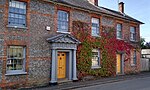
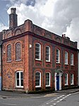
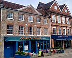
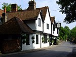
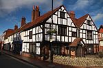
24 High Street
Hungerford House
1951
10 September 1951 SU3376168517 51°24′53″N 1°30′57″W / 51.414672°N 1.515928°W / 51.414672; -1.515928 (24 High Street ) 1210596 24 High Street
Church of St Michael
Lower Green, Inkpen
Church
13th century 6 February 1952 SU3577063776 51°22′19″N 1°29′15″W / 51.371921°N 1.487517°W / 51.371921; -1.487517 (Church of St Michael ) 1290597 Church of St Michael
Inkpen House
Lower Green, Inkpen
House
1984
10 September 1951 SU3580463731 51°22′17″N 1°29′13″W / 51.371515°N 1.487033°W / 51.371515; -1.487033 (Inkpen House ) 1290598 Inkpen House
Kirby House
Inkpen Country house
18th century 10 September 1951 SU3753163209 51°22′00″N 1°27′44″W / 51.36671°N 1.462279°W / 51.36671; -1.462279 (Kirby House ) 1221220 Kirby House
Church of St Mary
Kintbury Church
12th century 6 February 1962 SU3832767005 51°24′03″N 1°27′02″W / 51.400788°N 1.450437°W / 51.400788; -1.450437 (Church of St Mary ) 1117242 Church of St Mary
Bockhampton
Lambourn House
17th century 10 September 1951 SU3354478030 51°30′01″N 1°31′05″W / 51.500218°N 1.518148°W / 51.500218; -1.518148 (Bockhampton ) 1113654 Bockhampton
College House
Lambourn House
18th century 10 September 1951 SU3259578809 51°30′26″N 1°31′54″W / 51.507278°N 1.531748°W / 51.507278; -1.531748 (College House ) 1136235 College House
Ivy House
Lambourn House
Late 18th century 10 September 1951 SU3275178831 51°30′27″N 1°31′46″W / 51.507466°N 1.529498°W / 51.507466; -1.529498 (Ivy House ) 1136363 Ivy House
Manor Farmhouse
Eastbury , Lambourn Farmhouse
16th century 10 September 1951 SU3452177312 51°29′37″N 1°30′15″W / 51.493704°N 1.504144°W / 51.493704; -1.504144 (Manor Farmhouse ) 1113661 Upload Photo
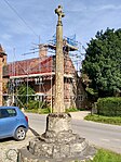
Market Cross
Lambourn Market cross
Medieval
10 September 1951 SU3265578936 51°30′30″N 1°31′51″W / 51.508416°N 1.530872°W / 51.508416; -1.530872 (Market Cross ) 1312843 Market Cross
Parsonage House
Lambourn House
16th century 10 September 1951 SU3252778936 51°30′30″N 1°31′58″W / 51.508423°N 1.532716°W / 51.508423; -1.532716 (Parsonage House ) 1113704 Parsonage House
Pigeon House
Eastbury , Lambourn Farmhouse
1620
10 September 1951 SU3491377076 51°29′30″N 1°29′55″W / 51.491558°N 1.498521°W / 51.491558; -1.498521 (Pigeon House ) 1136193 Pigeon House
The Pigeonhouse
Eastbury , Lambourn Dovecote
Early 17th century 10 September 1951 SU3488777128 51°29′31″N 1°29′56″W / 51.492027°N 1.498891°W / 51.492027; -1.498891 (The Pigeonhouse ) 1113675 Upload Photo
The Village Cross
Eastbury , Lambourn Cross
15th century 10 September 1951 SU3465277225 51°29′34″N 1°30′08″W / 51.492914°N 1.502266°W / 51.492914; -1.502266 (The Village Cross ) 1113669 The Village Cross
21 Newbury Street
Lambourn House
18th century 10 September 1951 SU3276578817 51°30′26″N 1°31′45″W / 51.50734°N 1.529298°W / 51.50734; -1.529298 (21 Newbury Street ) 1113701 21 Newbury Street
Church of St James
Leckhampstead Church
c .1858–606 April 1967 SU4393675958 51°28′51″N 1°22′07″W / 51.480879°N 1.368704°W / 51.480879; -1.368704 (Church of St James ) 1313057 Church of St James
Bridge over River Kennet
Newbury Bridge
1726
29 September 1950 SU4710567167 51°24′06″N 1°19′27″W / 51.401585°N 1.324241°W / 51.401585; -1.324241 (Bridge over River Kennet ) 1290920 Bridge over River Kennet
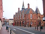
Corn Stores
Newbury Shop
1970
29 September 1950 SU4728867144 51°24′05″N 1°19′18″W / 51.401363°N 1.321613°W / 51.401363; -1.321613 (Corn Stores ) 1211914 Corn Stores
Falkland Garth
Newbury Farmhouse
17th century 29 September 1950 SU4580765024 51°22′57″N 1°20′35″W / 51.382423°N 1.343174°W / 51.382423; -1.343174 (Falkland Garth ) 1290696 Falkland Garth
Litten Chapel (part of the Newbury Commercial School)
Newbury School
1983
29 September 1950 SU4693866605 51°23′48″N 1°19′36″W / 51.396546°N 1.326715°W / 51.396546; -1.326715 (Litten Chapel (part of the Newbury Commercial School) ) 1210610 Litten Chapel (part of the Newbury Commercial School)
Methodist Chapel
Newbury Methodist chapel
1837–38 30 September 1977 SU4702667501 51°24′17″N 1°19′31″W / 51.404595°N 1.325332°W / 51.404595; -1.325332 (Methodist Chapel ) 1211202 Methodist Chapel
North gateway to churchyard of St Nicholas' Church adjoining Bartholomew Street
Newbury Gate
c .177010 June 1969 SU4710367115 51°24′04″N 1°19′27″W / 51.401118°N 1.324276°W / 51.401118; -1.324276 (North gateway to churchyard of St Nicholas' Church adjoining Bartholomew Street ) 1291318 North gateway to churchyard of St Nicholas' Church adjoining Bartholomew Street
South gateway to churchyard of St Nicholas' Church adjoining Bartholomew Street
Newbury Gate
c .177010 June 1969 SU4709767092 51°24′03″N 1°19′28″W / 51.400911°N 1.324365°W / 51.400911; -1.324365 (South gateway to churchyard of St Nicholas' Church adjoining Bartholomew Street ) 1291423 South gateway to churchyard of St Nicholas' Church adjoining Bartholomew Street
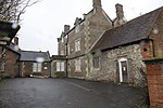
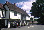
St Bartholomew's Hospital
Newbury Almshouse
c .161810 June 1969 SU4692966576 51°23′47″N 1°19′37″W / 51.396286°N 1.326848°W / 51.396286; -1.326848 (St Bartholomew's Hospital ) 1219550 St Bartholomew's Hospital
St Mary's Vicarage
Newbury Vicarage
c .18302 September 1983 SU4722167688 51°24′23″N 1°19′21″W / 51.40626°N 1.322504°W / 51.40626; -1.322504 (St Mary's Vicarage ) 1221172 St Mary's Vicarage
St Nicolas House
West Mills, Newbury
Town house
early-mid 18th century
29 September 1950 SU4697967067 51°24′03″N 1°19′34″W / 51.400696°N 1.326065°W / 51.400696; -1.326065 (St Nicolas House ) 1289887 St Nicolas House
The Chestnuts
Newbury House
Early–mid-18th century 29 September 1950 SU4687767683 51°24′22″N 1°19′39″W / 51.406243°N 1.32745°W / 51.406243; -1.32745 (The Chestnuts ) 1219909 The Chestnuts
Wessex Home
Newbury Villa
Early–mid-19th century 10 June 1969 SU4686267767 51°24′25″N 1°19′40″W / 51.407°N 1.327654°W / 51.407; -1.327654 (Wessex Home ) 1211380 Wessex Home
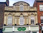
42 Northbrook Street
Newbury House
c .172429 September 1950 SU4709467496 51°24′16″N 1°19′28″W / 51.404544°N 1.324355°W / 51.404544; -1.324355 (42 Northbrook Street ) 1211030 42 Northbrook Street
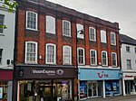
91 and 92 Northbrook Street
Newbury House
c .17402 September 1983 SU4707867262 51°24′09″N 1°19′29″W / 51.402441°N 1.324616°W / 51.402441; -1.324616 (91 and 92 Northbrook Street ) 1211267 91 and 92 Northbrook Street
24 Northbrook Street
Newbury House
Early 16th century 29 September 1950 SU4711067355 51°24′12″N 1°19′27″W / 51.403275°N 1.324144°W / 51.403275; -1.324144 (24 Northbrook Street ) 1290211 24 Northbrook Street
63 Cheap Street
Newbury Town house
c .179629 September 1950 SU4731266842 51°23′55″N 1°19′17″W / 51.398646°N 1.321308°W / 51.398646; -1.321308 (63 Cheap Street ) 1290759 63 Cheap Street
28 Bartholomew Street
Newbury Town house
Mid-18th century 2 September 1983 SU4700766929 51°23′58″N 1°19′32″W / 51.399453°N 1.325681°W / 51.399453; -1.325681 (28 Bartholomew Street ) 1219756 28 Bartholomew Street
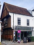
7–11 Northbrook Street
Newbury House
c .166929 September 1950 SU4711367253 51°24′08″N 1°19′27″W / 51.402358°N 1.324114°W / 51.402358; -1.324114 (7–11 Northbrook Street ) 1290298 7–11 Northbrook Street
5 Wharf Street
Newbury Town house
Early–mid-18th century 29 September 1950 SU4720967142 51°24′05″N 1°19′22″W / 51.401352°N 1.322749°W / 51.401352; -1.322749 (5 Wharf Street ) 1211738 5 Wharf Street
Padworth House
Padworth House
17th century 25 October 1951 SU6132166252 51°23′31″N 1°07′12″W / 51.392003°N 1.120062°W / 51.392003; -1.120062 (Padworth House ) 1117314 Upload Photo
Church of St James the Less
Pangbourne Church
1718
14 April 1967 SU6342076420 51°28′59″N 1°05′17″W / 51.483187°N 1.088081°W / 51.483187; -1.088081 (Church of St James the Less ) 1213980 Church of St James the Less
Devitt House, Pangbourne College
Pangbourne House
1897–98 19 June 1984 SU6191575545 51°28′32″N 1°06′36″W / 51.475487°N 1.109904°W / 51.475487; -1.109904 (Devitt House, Pangbourne College ) 1213514 Devitt House, Pangbourne College
Hill House/Little Court/Pangbourne English Centre
Pangbourne House
1971
7 December 1971 SU6310876764 51°29′11″N 1°05′33″W / 51.486315°N 1.092512°W / 51.486315; -1.092512 (Hill House/Little Court/Pangbourne English Centre ) 1214033 Upload Photo
The Junior School, Pangbourne College
Pangbourne House
1901
19 June 1984 SU6155776054 51°28′48″N 1°06′54″W / 51.480102°N 1.11497°W / 51.480102; -1.11497 (The Junior School, Pangbourne College ) 1288792 The Junior School, Pangbourne College
Church of St Mary
Purley on Thames Church
1626
14 April 1967 SU6674276059 51°28′46″N 1°02′25″W / 51.47956°N 1.040316°W / 51.47956; -1.040316 (Church of St Mary ) 1288375 Church of St Mary
Purley Hall including stable yard adjoining to east
Purley on Thames House
1609
25 October 1951 SU6461775776 51°28′38″N 1°04′15″W / 51.477262°N 1.070963°W / 51.477262; -1.070963 (Purley Hall including stable yard adjoining to east ) 1214696 Upload Photo
Purley Park
Purley on Thames House
Designed 1795
25 October 1951 SU6652575857 51°28′40″N 1°02′37″W / 51.47777°N 1.043478°W / 51.47777; -1.043478 (Purley Park ) 1288453 Upload Photo
Donnington Grove
Donnington , Shaw-cum-Donnington House
c .17826 June 1952 SU4585268959 51°25′04″N 1°20′31″W / 51.417799°N 1.34202°W / 51.417799; -1.34202 (Donnington Grove ) 1220450 Upload Photo
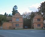
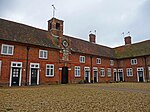
Donnington Hospital
Shaw-cum-Donnington Courtyard
1602
6 June 1952 SU4656468593 51°24′52″N 1°19′55″W / 51.414451°N 1.33183°W / 51.414451; -1.33183 (Donnington Hospital ) 1290987 Donnington Hospital
Benham Park
Speen Country house
1772–75 6 June 1952 SU4401167742 51°24′25″N 1°22′07″W / 51.407003°N 1.368644°W / 51.407003; -1.368644 (Benham Park ) 1220740 Benham Park
Dumbledore
Jennetts Hill, Stanford Dingley
House
17th century 29 November 1983 SU5787971119 51°26′10″N 1°10′07″W / 51.436121°N 1.168733°W / 51.436121; -1.168733 (Dumbledore ) 1213110 Upload Photo
The Old Rectory
Stanford Dingley House
c .172029 November 1983 SU5748771340 51°26′17″N 1°10′28″W / 51.438148°N 1.174336°W / 51.438148; -1.174336 (The Old Rectory ) 1213108 Upload Photo
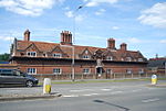
Mortimer Station
Stratfield Mortimer Railway station
1848
4 September 1975 SU6721864112 51°22′20″N 1°02′09″W / 51.372097°N 1.035725°W / 51.372097; -1.035725 (Mortimer Station ) 1117145 Mortimer Station
Waiting room at Mortimer Station on south-west side of railway line
Stratfield Mortimer Railway station
1848
28 January 1987 SU6722964103 51°22′19″N 1°02′08″W / 51.372014°N 1.035569°W / 51.372014; -1.035569 (Waiting room at Mortimer Station on south-west side of railway line ) 1135802 Waiting room at Mortimer Station on south-west side of railway line
Streatley Farmhouse
Streatley Farmhouse
1675
29 November 1983 SU5932882000 51°32′02″N 1°08′46″W / 51.533797°N 1.146065°W / 51.533797; -1.146065 (Streatley Farmhouse ) 1213575 Upload Photo
Streatley House
Streatley House
Late 18th century 29 November 1983 SU5936380763 51°31′22″N 1°08′45″W / 51.522672°N 1.145769°W / 51.522672; -1.145769 (Streatley House ) 1213395 Streatley House
Sulham Farmhouse
Sulham Farmhouse
c .158019 June 1984 SU6444474238 51°27′48″N 1°04′25″W / 51.463455°N 1.073733°W / 51.463455; -1.073733 (Sulham Farmhouse ) 1288378 Sulham Farmhouse
Church of St Mary
Thatcham Church
12th century 6 April 1967 SU5164867229 51°24′06″N 1°15′32″W / 51.401748°N 1.25893°W / 51.401748; -1.25893 (Church of St Mary ) 1155799 Church of St Mary
Calcot Court
Calcot Park , Tilehurst Flats
1984
25 October 1951 SU6720472275 51°26′44″N 1°02′04″W / 51.445486°N 1.034382°W / 51.445486; -1.034382 (Calcot Court ) 1215858 Calcot Court
Church of St Gregory
Welford Church
Late 19th century 6 March 1985 SU4088373156 51°27′21″N 1°24′47″W / 51.455914°N 1.412989°W / 51.455914; -1.412989 (Church of St Gregory ) 1117225 Church of St Gregory
Church of St Swithin
Wickham , Welford Church
Saxon/Anglo Saxon
6 April 1967 SU3947271520 51°26′29″N 1°26′01″W / 51.441305°N 1.433477°W / 51.441305; -1.433477 (Church of St Swithin ) 1319533 Church of St Swithin
Entrance gates, piers and railings to West Woodhay House
West Woodhay Gate
18th century 29 October 1984 SU3860963306 51°22′03″N 1°26′48″W / 51.36751°N 1.446785°W / 51.36751; -1.446785 (Entrance gates, piers and railings to West Woodhay House ) 1210179 Upload Photo
Church of St James
Winterbourne Church
12th century 6 April 1967 SU4506971939 51°26′41″N 1°21′10″W / 51.444655°N 1.352901°W / 51.444655; -1.352901 (Church of St James ) 1221003 Church of St James
Hop Castle (approximately 300 metres to north-west of Penclose Farmhouse)
Winterbourne House
1983
24 August 1978 SU4465473766 51°27′40″N 1°21′31″W / 51.461114°N 1.358642°W / 51.461114; -1.358642 (Hop Castle (approximately 300 metres to north-west of Penclose Farmhouse) ) 1221027 Upload Photo
Wokefield Park
Wokefield House
Early 18th century 14 April 1967 SU6733165687 51°23′10″N 1°02′02″W / 51.386243°N 1.033804°W / 51.386243; -1.033804 (Wokefield Park ) 1135957 Wokefield Park
Douai Abbey Church
Upper Woolhampton Abbey
1928–33 10 November 1983 SU5770468214 51°24′36″N 1°10′18″W / 51.410021°N 1.171722°W / 51.410021; -1.171722 (Douai Abbey Church ) 1156252 Douai Abbey Church
Elstree School, Woolhampton House
Upper Woolhampton House
17th century 9 September 1969 SU5768367525 51°24′14″N 1°10′20″W / 51.403829°N 1.172136°W / 51.403829; -1.172136 (Elstree School, Woolhampton House ) 1117267 Elstree School, Woolhampton House
The Rectory
Upper Woolhampton House
Early 18th century 10 November 1983 SU5748368048 51°24′31″N 1°10′30″W / 51.408551°N 1.174926°W / 51.408551; -1.174926 (The Rectory ) 1319552 Upload Photo
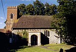
Church of All Saints
Brightwalton Church
1862
27 June 1972 SU4270679300 51°30′40″N 1°23′10″W / 51.511020°N 1.3860122°W / 51.511020; -1.3860122 (Church of All Saints ) 1117194 Church of All Saints