149:
939:
882:
25:
156:
133:
258:
655:
999:
856:
861:
389:
1014:
851:
415:
175:
380:
923:
745:
980:
148:
1019:
495:
197:
505:
889:
270:
1004:
400:
635:
373:
108:
42:
1009:
725:
545:
916:
430:
89:
293:
61:
46:
973:
550:
366:
68:
700:
909:
75:
337:
966:
805:
785:
755:
650:
57:
775:
740:
410:
286:
185:
35:
815:
520:
830:
820:
710:
405:
358:
835:
735:
665:
595:
760:
630:
615:
605:
560:
765:
715:
705:
670:
585:
580:
525:
810:
625:
590:
480:
465:
309:
82:
780:
645:
640:
530:
515:
485:
475:
460:
730:
690:
570:
248:
540:
881:
950:
893:
825:
800:
795:
790:
450:
440:
938:
993:
946:
685:
675:
565:
535:
445:
435:
278:
720:
695:
610:
575:
510:
470:
660:
620:
500:
455:
420:
274:
24:
132:
750:
425:
282:
212:
199:
770:
600:
490:
317:
313:
297:
680:
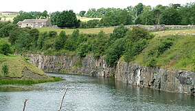
308:. At the western end of the quarry is a unique exposure that displays
301:
656:
Muggleswick, Stanhope and
Edmundbyers Commons and Blanchland Moor
362:
18:
300:; there are other exposures in the bed of the Wear near the
954:
897:
1000:
Sites of
Special Scientific Interest in County Durham
390:
Sites of
Special Scientific Interest in County Durham
254:
244:
236:
228:
191:
181:
171:
125:
49:. Unsourced material may be challenged and removed.
416:Bollihope, Pikestone, Eggleston and Woodland Fells
1015:English Site of Special Scientific Interest stubs
338:"Greenfoot Quarry : Reasons for SSSI status"
304:, but none shows so complete of an exposure as
974:
917:
374:
8:
981:
967:
924:
910:
381:
367:
359:
122:
285:, 1 km upstream from the village of
281:, England. It is a disused quarry in the
109:Learn how and when to remove this message
155:
329:
746:Sleightholme Beck Gorge – The Troughs
496:Crime Rigg and Sherburn Hill Quarries
7:
935:
933:
878:
876:
506:Derwent Gorge and Horsleyhope Ravine
170:
47:adding citations to reliable sources
890:Site of Special Scientific Interest
271:Site of Special Scientific Interest
163:Site of Special Scientific Interest
401:Backstone Bank and Baal Hill Woods
14:
636:Middle Side and Stonygill Meadows
937:
880:
726:Rigg Farm and Stake Hill Meadows
154:
147:
131:
23:
431:Bowlees and Friar House Meadows
235:
180:
34:needs additional citations for
294:national geological importance
1:
1020:County Durham geography stubs
953:. You can help Knowledge by
896:. You can help Knowledge by
551:Green Croft and Langley Moor
316:exposed above and below the
701:Quarrington Hill Grasslands
1036:
932:
875:
546:Grains o' th' Beck Meadows
1005:Quarries in County Durham
844:
396:
296:for its exposures of the
142:
130:
806:West Newlandside Meadows
786:Trimdon Limestone Quarry
756:Stony Cut, Cold Hesledon
651:Moorhouse and Cross Fell
16:Disused quarry in Durham
1010:Stanhope, County Durham
776:Thrislington Plantation
741:Shipley and Great Woods
411:Bishop Middleham Quarry
232:0.9 ha (2.2 acres)
949:location article is a
816:West Rigg Open Cutting
521:Far High House Meadows
888:This article about a
821:Westernhope Burn Wood
711:Raisby Hill Grassland
406:Baldersdale Woodlands
259:Greenfoot Quarry SSSI
836:Yoden Village Quarry
666:Newton Ketton Meadow
596:Hisehope Burn Valley
213:54.74833°N 2.02861°W
43:improve this article
761:Teesdale Allotments
631:Middle Crossthwaite
616:Low Redford Meadows
606:Hunder Beck Juniper
245:Governing body
209: /
848:Neighbouring areas
716:Raisby Hill Quarry
706:Railway Stell West
671:Old Moss Lead Vein
586:Hesledon Moor West
581:Hesledon Moor East
526:Fishburn Grassland
218:54.74833; -2.02861
58:"Greenfoot Quarry"
962:
961:
905:
904:
870:
869:
811:West Park Meadows
626:Mere Beck Meadows
591:Hexhamshire Moors
481:Cornriggs Meadows
466:Causey Bank Mires
343:. Natural England
312:in the sill with
310:columnar jointing
277:district of west
264:
263:
182:Nearest town
119:
118:
111:
93:
1027:
983:
976:
969:
941:
934:
926:
919:
912:
892:in England is a
884:
877:
781:Town Kelloe Bank
646:Middridge Quarry
641:Middleton Quarry
561:Hannah's Meadows
556:Greenfoot Quarry
516:Fairy Holes Cave
486:Cotherstone Moor
476:Close House Mine
461:Castle Eden Dene
383:
376:
369:
360:
353:
352:
350:
348:
342:
334:
306:Greenfoot Quarry
298:Little Whin Sill
267:Greenfoot Quarry
224:
223:
221:
220:
219:
214:
210:
207:
206:
205:
202:
158:
157:
151:
137:Greenfoot Quarry
135:
126:Greenfoot Quarry
123:
114:
107:
103:
100:
94:
92:
51:
27:
19:
1035:
1034:
1030:
1029:
1028:
1026:
1025:
1024:
990:
989:
988:
987:
931:
930:
873:
871:
866:
840:
731:Rogerley Quarry
691:Pittington Hill
571:Hawthorn Quarry
392:
387:
357:
356:
346:
344:
340:
336:
335:
331:
326:
249:Natural England
217:
215:
211:
208:
203:
200:
198:
196:
195:
167:
166:
165:
164:
161:
160:
159:
138:
115:
104:
98:
95:
52:
50:
40:
28:
17:
12:
11:
5:
1033:
1031:
1023:
1022:
1017:
1012:
1007:
1002:
992:
991:
986:
985:
978:
971:
963:
960:
959:
942:
929:
928:
921:
914:
906:
903:
902:
885:
868:
867:
865:
864:
859:
857:Northumberland
854:
849:
845:
842:
841:
839:
838:
833:
831:Witton-le-Wear
828:
826:Wingate Quarry
823:
818:
813:
808:
803:
801:Waldridge Fell
798:
796:Upper Teesdale
793:
791:Tuthill Quarry
788:
783:
778:
773:
768:
763:
758:
753:
748:
743:
738:
733:
728:
723:
718:
713:
708:
703:
698:
693:
688:
683:
678:
673:
668:
663:
658:
653:
648:
643:
638:
633:
628:
623:
618:
613:
608:
603:
598:
593:
588:
583:
578:
573:
568:
563:
558:
553:
548:
543:
538:
533:
528:
523:
518:
513:
508:
503:
498:
493:
488:
483:
478:
473:
468:
463:
458:
453:
451:Butterby Oxbow
448:
443:
441:Brignall Banks
438:
433:
428:
423:
418:
413:
408:
403:
397:
394:
393:
388:
386:
385:
378:
371:
363:
355:
354:
328:
327:
325:
322:
262:
261:
256:
252:
251:
246:
242:
241:
238:
234:
233:
230:
226:
225:
193:
189:
188:
183:
179:
178:
173:
169:
168:
162:
153:
152:
146:
145:
144:
143:
140:
139:
136:
128:
127:
117:
116:
31:
29:
22:
15:
13:
10:
9:
6:
4:
3:
2:
1032:
1021:
1018:
1016:
1013:
1011:
1008:
1006:
1003:
1001:
998:
997:
995:
984:
979:
977:
972:
970:
965:
964:
958:
956:
952:
948:
947:County Durham
943:
940:
936:
927:
922:
920:
915:
913:
908:
907:
901:
899:
895:
891:
886:
883:
879:
874:
863:
862:Tyne and Wear
860:
858:
855:
853:
850:
847:
846:
843:
837:
834:
832:
829:
827:
824:
822:
819:
817:
814:
812:
809:
807:
804:
802:
799:
797:
794:
792:
789:
787:
784:
782:
779:
777:
774:
772:
769:
767:
764:
762:
759:
757:
754:
752:
749:
747:
744:
742:
739:
737:
736:Sherburn Hill
734:
732:
729:
727:
724:
722:
719:
717:
714:
712:
709:
707:
704:
702:
699:
697:
694:
692:
689:
687:
686:Pike Whin Bog
684:
682:
679:
677:
676:Park End Wood
674:
672:
669:
667:
664:
662:
659:
657:
654:
652:
649:
647:
644:
642:
639:
637:
634:
632:
629:
627:
624:
622:
619:
617:
614:
612:
609:
607:
604:
602:
599:
597:
594:
592:
589:
587:
584:
582:
579:
577:
574:
572:
569:
567:
566:Hawthorn Dene
564:
562:
559:
557:
554:
552:
549:
547:
544:
542:
539:
537:
536:Frog Wood Bog
534:
532:
531:Foster's Hush
529:
527:
524:
522:
519:
517:
514:
512:
509:
507:
504:
502:
499:
497:
494:
492:
489:
487:
484:
482:
479:
477:
474:
472:
469:
467:
464:
462:
459:
457:
454:
452:
449:
447:
446:Burnhope Burn
444:
442:
439:
437:
436:Brasside Pond
434:
432:
429:
427:
424:
422:
419:
417:
414:
412:
409:
407:
404:
402:
399:
398:
395:
391:
384:
379:
377:
372:
370:
365:
364:
361:
339:
333:
330:
323:
321:
319:
315:
311:
307:
303:
299:
295:
292:The site has
290:
288:
284:
280:
279:County Durham
276:
272:
268:
260:
257:
253:
250:
247:
243:
239:
231:
227:
222:
194:
190:
187:
184:
177:
174:
150:
141:
134:
129:
124:
121:
113:
110:
102:
91:
88:
84:
81:
77:
74:
70:
67:
63:
60: –
59:
55:
54:Find sources:
48:
44:
38:
37:
32:This article
30:
26:
21:
20:
955:expanding it
944:
898:expanding it
887:
872:
721:Redcar Field
696:Pow Hill Bog
611:Kilmond Scar
576:Hell Kettles
555:
541:God's Bridge
511:Durham Coast
471:Charity Land
345:. Retrieved
332:
305:
291:
266:
265:
120:
105:
96:
86:
79:
72:
65:
53:
41:Please help
36:verification
33:
766:The Bottoms
661:Neasham Fen
621:Lune Forest
501:Dabble Bank
456:Cassop Vale
421:Botany Hill
283:Wear valley
275:Wear Valley
237:Established
216: /
192:Coordinates
994:Categories
751:Slit Woods
426:Bowes Moor
324:References
201:54°44′54″N
69:newspapers
852:Cleveland
771:The Carrs
601:Hulam Fen
491:Crag Gill
318:intrusion
314:limestone
176:MAGiC MaP
99:July 2024
681:Pig Hill
287:Stanhope
204:2°1′43″W
186:Stanhope
172:Location
347:1 April
273:in the
255:Website
83:scholar
302:quarry
85:
78:
71:
64:
56:
945:This
341:(PDF)
269:is a
90:JSTOR
76:books
951:stub
894:stub
349:2022
240:1984
229:Area
62:news
45:by
996::
320:.
289:.
982:e
975:t
968:v
957:.
925:e
918:t
911:v
900:.
382:e
375:t
368:v
351:.
112:)
106:(
101:)
97:(
87:·
80:·
73:·
66:·
39:.
Text is available under the Creative Commons Attribution-ShareAlike License. Additional terms may apply.