65:
77:
1037:
51:
85:
189:
736:
In the township the population was spread out, with 27.0% under the age of 18, 6.9% from 18 to 24, 27.6% from 25 to 44, 25.7% from 45 to 64, and 12.8% who were 65 years of age or older. The median age was 38 years. For every 100 females there were 105.2 males. For every 100 females age 18 and over,
732:
living together, 2.1% had a female householder with no husband present, and 21.6% were non-families. 16.5% of all households were made up of individuals, and 7.7% had someone living alone who was 65 years of age or older. The average household size was 2.82 and the average family size was 3.24.
704:
of 2000, there were 548 people, 194 households, and 152 families residing in the township. The population density was 27.9 inhabitants per square mile (10.8/km). There were 223 housing units at an average density of 11.3/sq mi (4.4/km). The racial makeup of the township was 98.54%
76:
64:
1250:
740:
The median income for a household in the township was $ 40,139, and the median income for a family was $ 40,417. Males had a median income of $ 32,054 versus $ 20,875 for females. The
960:
1294:
1100:
348:
17:
1110:
1070:
1060:
356:
1085:
352:
1289:
1115:
1090:
344:
1080:
843:
953:
274:
90:
946:
1148:
878:
317:
1095:
328:
Greenwood
Township is in eastern Juniata County and is centered on Turkey Valley, with Shellys Ridge and Lock Ridge to the south.
764:
121:
938:
794:
1105:
1065:
710:
340:, the township has a total area of 19.5 square miles (50.4 km), of which 0.9 acres (3,723 m), or 0.01%, are water.
50:
1143:
1133:
1055:
970:
293:
126:
1227:
1199:
923:
851:
337:
1026:
221:
1184:
1016:
992:
666:
651:
636:
621:
606:
591:
576:
561:
546:
531:
516:
501:
486:
471:
456:
441:
426:
411:
313:
301:
55:
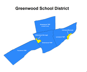
1179:
1164:
1138:
1021:
374:
262:
99:
844:"Geographic Identifiers: 2010 Census Summary File 1 (G001): Greenwood township, Juniata County, Pennsylvania"
1174:
1153:
1125:
1047:
728:
There were 194 households, out of which 33.0% had children under the age of 18 living with them, 74.7% were
366:
289:
41:
1204:
1003:
718:
362:
1011:
883:
242:
1234:
722:
231:
714:
706:
1194:
1189:
744:
for the township was $ 17,344. About 5.0% of families and 7.0% of the population were below the
897:
84:
814:
741:
370:
359:
to the west. Unincorporated communities in the township include Seven Stars and
Dimmsville.
826:
329:
1283:
333:
267:
745:
297:
114:
985:
109:
1265:
1252:
212:
1218:‡This populated place also has portions in an adjacent county or counties.
748:, including 5.4% of those under age 18 and 5.5% of those age 65 or over.
729:
250:
701:
336:, flows through the western part of the township. According to the
89:
Greenwood
Township is one of six municipalities encompassed by the
69:
Map of
Juniata County, Pennsylvania highlighting Greenwood Township
238:
217:
873:
942:
1035:
919:
16:
304:, an increase over the figure of 617 tabulated in 2010.
788:
786:
784:
782:
1213:
1163:
1124:
1046:
1002:
273:
261:
249:
228:
211:
203:
195:
182:
177:
169:
161:
153:
148:
140:
132:
120:
108:
98:
28:
18:Greenwood Township, Pennsylvania (disambiguation)
300:, United States. The population was 533 at the
954:
838:
836:
365:passes through the township, leading east to
8:
795:"City and Town Population Totals: 2020-2022"
961:
947:
939:
725:of any race were 0.73% of the population.
384:
25:
1295:Townships in Juniata County, Pennsylvania
756:
272:
248:
210:
176:
147:
131:
97:
61:
47:
23:Township in Pennsylvania, United States
874:"National Register Information System"
822:
812:
404:
260:
227:
202:
194:
181:
168:
165:19.46 sq mi (50.40 km)
160:
157:19.46 sq mi (50.40 km)
152:
139:
119:
107:
73:
7:
1290:Populated places established in 1763
879:National Register of Historic Places
850:. U.S. Census Bureau. Archived from
717:, and 0.55% from two or more races.
318:National Register of Historic Places
81:Map of Juniata County, Pennsylvania
173:0.00 sq mi (0.00 km)
969:Municipalities and communities of
898:"Census of Population and Housing"
394:
343:Greenwood Township is bordered by
14:
353:Greenwood Township, Perry County
188:
187:
83:
75:
63:
49:
320:in 1979. It collapsed in 2017.
1:
767:. United States Census Bureau
972:Juniata County, Pennsylvania
924:United States Census Bureau
765:"2016 U.S. Gazetteer Files"
338:United States Census Bureau
207:32.22/sq mi (12.44/km)
196: • Estimate
1311:
15:
1223:
1033:
983:
693:
680:
665:
650:
635:
620:
605:
590:
575:
560:
545:
530:
515:
500:
485:
470:
455:
440:
425:
410:
403:
398:
393:
390:
314:Dimmsville Covered Bridge
91:Greenwood School District
74:
62:
56:Dimmsville Covered Bridge
48:
39:
737:there were 99.0 males.
1040:
363:Pennsylvania Route 235
1266:40.61667°N 77.11639°W
1039:
920:"U.S. Census website"
884:National Park Service
694:U.S. Decennial Census
386:Historical population
332:, a tributary of the
230: • Summer (
1236:United States portal
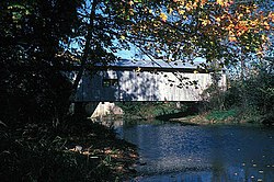
854:on February 13, 2020
349:Susquehanna Township
204: • Density
1271:40.61667; -77.11639
1262: /
1229:Pennsylvania portal
848:American Factfinder
793:Bureau, US Census.
387:
30:Greenwood Township,
1041:
825:has generic name (
801:. US Census Bureau
385:
355:to the south, and
316:was listed on the
286:Greenwood Township
183: • Total
170: • Water
154: • Total
1245:
1244:
742:per capita income
698:
697:
371:Susquehanna River
357:Delaware Township
283:
282:
162: • Land
1302:
1277:
1276:
1274:
1273:
1272:
1267:
1263:
1260:
1259:
1258:
1255:
1237:
1230:
1038:
995:
988:
978:
973:
963:
956:
949:
940:
934:
933:
931:
930:
916:
910:
909:
907:
905:
894:
888:
887:
870:
864:
863:
861:
859:
840:
831:
830:
824:
820:
818:
810:
808:
806:
790:
777:
776:
774:
772:
761:
711:African American
406:
401:
396:
388:
235:
191:
190:
87:
79:
67:
53:
26:
1310:
1309:
1305:
1304:
1303:
1301:
1300:
1299:
1280:
1279:
1270:
1268:
1264:
1261:
1256:
1253:
1251:
1249:
1248:
1246:
1241:
1235:
1228:
1219:
1209:
1166:
1159:
1120:
1042:
1036:
1031:
998:
993:
986:
979:
976:
971:
967:
937:
928:
926:
918:
917:
913:
903:
901:
896:
895:
891:
886:. July 9, 2010.
872:
871:
867:
857:
855:
842:
841:
834:
821:
811:
804:
802:
792:
791:
780:
770:
768:
763:
762:
758:
754:
730:married couples
399:
383:
345:Monroe Township
330:Cocolamus Creek
326:
310:
257:
229:
94:
70:
58:
44:
35:
33:
32:Juniata County,
31:
24:
21:
12:
11:
5:
1308:
1306:
1298:
1297:
1292:
1282:
1281:
1243:
1242:
1240:
1239:
1232:
1224:
1221:
1220:
1217:
1215:
1211:
1210:
1208:
1207:
1202:
1197:
1192:
1187:
1182:
1177:
1171:
1169:
1165:Unincorporated
1161:
1160:
1158:
1157:
1151:
1146:
1144:McAlisterville
1141:
1136:
1134:East Waterford
1130:
1128:
1122:
1121:
1119:
1118:
1113:
1108:
1103:
1098:
1093:
1088:
1083:
1078:
1073:
1068:
1063:
1058:
1052:
1050:
1044:
1043:
1034:
1032:
1030:
1029:
1024:
1019:
1014:
1008:
1006:
1000:
999:
984:
981:
980:
968:
966:
965:
958:
951:
943:
936:
935:
911:
889:
865:
832:
778:
755:
753:
750:
696:
695:
691:
690:
687:
685:
682:
678:
677:
674:
672:
669:
663:
662:
659:
657:
654:
648:
647:
644:
642:
639:
633:
632:
629:
627:
624:
618:
617:
614:
612:
609:
603:
602:
599:
597:
594:
588:
587:
584:
582:
579:
573:
572:
569:
567:
564:
558:
557:
554:
552:
549:
543:
542:
539:
537:
534:
528:
527:
524:
522:
519:
513:
512:
509:
507:
504:
498:
497:
494:
492:
489:
483:
482:
479:
477:
474:
468:
467:
464:
462:
459:
453:
452:
449:
447:
444:
438:
437:
434:
432:
429:
423:
422:
419:
417:
414:
408:
407:
402:
397:
392:
382:
379:
373:, and west to
347:to the north,
325:
322:
309:
306:
294:Juniata County
281:
280:
277:
271:
270:
265:
259:
258:
255:
253:
247:
246:
236:
226:
225:
215:
209:
208:
205:
201:
200:
197:
193:
192:
184:
180:
179:
175:
174:
171:
167:
166:
163:
159:
158:
155:
151:
150:
146:
145:
142:
138:
137:
134:
130:
129:
124:
118:
117:
112:
106:
105:
102:
96:
95:
80:
72:
71:
68:
60:
59:
54:
46:
45:
40:
37:
36:
29:
22:
13:
10:
9:
6:
4:
3:
2:
1307:
1296:
1293:
1291:
1288:
1287:
1285:
1278:
1275:
1238:
1233:
1231:
1226:
1225:
1222:
1216:
1212:
1206:
1203:
1201:
1200:Oakland Mills
1198:
1196:
1193:
1191:
1188:
1186:
1183:
1181:
1178:
1176:
1173:
1172:
1170:
1168:
1162:
1155:
1152:
1150:
1147:
1145:
1142:
1140:
1137:
1135:
1132:
1131:
1129:
1127:
1123:
1117:
1114:
1112:
1109:
1107:
1104:
1102:
1099:
1097:
1094:
1092:
1089:
1087:
1084:
1082:
1079:
1077:
1074:
1072:
1069:
1067:
1064:
1062:
1059:
1057:
1054:
1053:
1051:
1049:
1045:
1028:
1025:
1023:
1020:
1018:
1015:
1013:
1010:
1009:
1007:
1005:
1001:
997:
996:
989:
982:
977:United States
974:
964:
959:
957:
952:
950:
945:
944:
941:
925:
921:
915:
912:
899:
893:
890:
885:
881:
880:
875:
869:
866:
853:
849:
845:
839:
837:
833:
828:
816:
800:
796:
789:
787:
785:
783:
779:
766:
760:
757:
751:
749:
747:
743:
738:
734:
731:
726:
724:
720:
716:
712:
708:
703:
692:
688:
686:
683:
679:
675:
673:
670:
668:
664:
660:
658:
655:
653:
649:
645:
643:
640:
638:
634:
630:
628:
625:
623:
619:
615:
613:
610:
608:
604:
600:
598:
595:
593:
589:
585:
583:
580:
578:
574:
570:
568:
565:
563:
559:
555:
553:
550:
548:
544:
540:
538:
535:
533:
529:
525:
523:
520:
518:
514:
510:
508:
505:
503:
499:
495:
493:
490:
488:
484:
480:
478:
475:
473:
469:
465:
463:
460:
458:
454:
450:
448:
445:
443:
439:
435:
433:
430:
428:
424:
420:
418:
415:
413:
409:
389:
380:
378:
376:
372:
368:
364:
360:
358:
354:
351:to the east,
350:
346:
341:
339:
335:
334:Juniata River
331:
323:
321:
319:
315:
307:
305:
303:
299:
295:
291:
287:
278:
276:
269:
266:
264:
254:
252:
244:
240:
237:
233:
223:
219:
216:
214:
206:
198:
185:
172:
164:
156:
143:
135:
128:
125:
123:
116:
113:
111:
104:United States
103:
101:
92:
88:
86:
78:
66:
57:
52:
43:
38:
27:
19:
1247:
1075:
1027:Thompsontown
991:
927:. Retrieved
914:
902:. Retrieved
900:. Census.gov
892:
877:
868:
858:November 21,
856:. Retrieved
852:the original
847:
823:|last1=
803:. Retrieved
798:
769:. Retrieved
759:
746:poverty line
739:
735:
727:
699:
381:Demographics
361:
342:
327:
311:
298:Pennsylvania
285:
284:
279:42-067-31424
141:Incorporated
115:Pennsylvania
82:
34:Pennsylvania
1269: /
1185:Honey Grove
1167:communities
1101:Susquehanna
1096:Spruce Hill
1017:Mifflintown
994:Mifflintown
987:County seat
805:January 31,
681:2022 (est.)
302:2020 census
1284:Categories
1257:77°06′59″W
1254:40°37′00″N
1180:Cuba Mills
1139:East Salem
1022:Port Royal
929:2008-01-31
799:Census.gov
752:References
700:As of the
375:East Salem
178:Population
1214:Footnotes
1175:Cocolamus
1154:Richfield
1111:Tuscarora
1076:Greenwood
1071:Fermanagh
1048:Townships
367:Liverpool
324:Geography
275:FIPS code
263:Area code
213:Time zone
1205:Oriental
1061:Delaware
1004:Boroughs
815:cite web
719:Hispanic
713:, 0.18%
709:, 0.73%
290:township
251:Zip code
42:Township
1106:Turbett
1086:Milford
1066:Fayette
1012:Mifflin
904:June 4,
771:Aug 14,
369:on the
308:History
133:Settled
127:Juniata
100:Country
1149:Mexico
1116:Walker
1091:Monroe
723:Latino
702:census
676:−13.6%
571:−19.9%
541:−19.4%
511:−20.6%
466:−19.2%
436:−61.5%
391:Census
122:County
1056:Beale
715:Asian
707:White
661:12.6%
646:11.2%
616:25.6%
586:23.4%
526:−3.1%
496:−1.1%
481:−5.3%
451:17.2%
416:1,651
288:is a
256:17062
239:UTC-4
218:UTC-5
110:State
1195:Nook
1190:Maze
1126:CDPs
1081:Lack
906:2016
860:2018
827:help
807:2024
773:2017
689:1.1%
667:2020
652:2010
637:2000
631:1.4%
622:1990
607:1980
601:9.6%
592:1970
577:1960
562:1950
556:2.3%
547:1940
532:1930
517:1920
502:1910
487:1900
472:1890
457:1880
442:1870
427:1860
412:1850
400:Note
395:Pop.
312:The
186:533
149:Area
144:1767
136:1763
721:or
684:539
671:533
656:617
641:548
626:493
611:486
596:387
581:353
566:286
551:357
536:349
521:433
506:447
491:563
476:569
461:601
446:744
431:635
292:in
268:717
243:EDT
232:DST
222:EST
199:539
1286::
990::
975:,
922:.
882:.
876:.
846:.
835:^
819::
817:}}
813:{{
797:.
781:^
405:%±
377:.
296:,
1156:‡
962:e
955:t
948:v
932:.
908:.
862:.
829:)
809:.
775:.
421:—
245:)
241:(
234:)
224:)
220:(
93:.
20:.
Text is available under the Creative Commons Attribution-ShareAlike License. Additional terms may apply.