137:
26:
63:
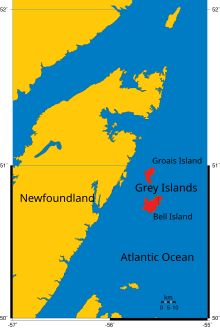
Largest of them is the southern Bell Island with an area of 88 km. The islands are hilly, rising to over 152 m. (500 ft). The village of Grey
Islands Harbour was situated at the southern end of Bell Island; the village of Sandy Cove was on Groais Island. Both islands had been evacuated by
178:
202:
197:
171:
17:
164:
98:
73:
90:
41:
144:
78:
53:
49:
136:
148:
57:
25:
191:
45:
113:
100:
34:
24:
91:"Grey Islands". The Columbia Gazetteer of North America, 2000.
16:
For the Bell Island in
Conception Bay, Newfoundland, see
152:
172:
8:
179:
165:
203:Newfoundland and Labrador geography stubs
7:
198:Islands of Newfoundland and Labrador
133:
131:
151:. You can help Knowledge (XXG) by
14:
135:
1:
74:Humber—St. Barbe—Baie Verte
219:
130:
15:
145:Newfoundland and Labrador
79:List of islands of Canada
54:Great Northern Peninsula
40:consist of two islands,
147:location article is a
30:
28:
110: /
56:to the east in the
31:
160:
159:
114:50.833°N 55.583°W
64:the early 1970s.
210:
181:
174:
167:
139:
132:
125:
124:
122:
121:
120:
115:
111:
108:
107:
106:
103:
218:
217:
213:
212:
211:
209:
208:
207:
188:
187:
186:
185:
128:
119:50.833; -55.583
118:
116:
112:
109:
104:
101:
99:
97:
96:
87:
70:
21:
12:
11:
5:
216:
214:
206:
205:
200:
190:
189:
184:
183:
176:
169:
161:
158:
157:
140:
94:
93:
86:
83:
82:
81:
76:
69:
66:
58:Atlantic Ocean
48:, located off
13:
10:
9:
6:
4:
3:
2:
215:
204:
201:
199:
196:
195:
193:
182:
177:
175:
170:
168:
163:
162:
156:
154:
150:
146:
141:
138:
134:
129:
126:
123:
92:
89:
88:
84:
80:
77:
75:
72:
71:
67:
65:
61:
59:
55:
51:
47:
46:Groais Island
43:
39:
36:
29:Grey Islands.
27:
23:
19:
153:expanding it
142:
127:
95:
62:
50:Newfoundland
38:Grey Islands
37:
32:
22:
117: /
42:Bell Island
18:Bell Island
192:Categories
68:See also
35:Canadian
105:55°35′W
102:50°50′N
85:Sources
143:This
149:stub
44:and
33:The
52:'s
194::
60:.
180:e
173:t
166:v
155:.
20:.
Text is available under the Creative Commons Attribution-ShareAlike License. Additional terms may apply.