31:
47:
1306:
54:
241:
490:
528:
663:
155:
515:
265:
1347:
112:
473:. Norfolk County Council have allocated a £40,000 contribution towards funding of the scheme. A schematic map of the scheme has been published online.
656:
604:
649:
367:, increasing to a population of 1,540 in 246 households at the 2011 Census. For the purposes of local government, it falls within the
253:
1376:
307:
270:
536:
1381:
289:
1275:
258:
225:
191:
46:
1340:
30:
105:
1366:
842:
1371:
575:
461:
Connect2 project proposals are in place to create a cycling and walking route between
Griston and the market town of
364:
363:. It covers an area of 5.62 km (2.17 sq mi) and had a population of 1,206 in 206 households at the
1333:
1270:
426:
The villages name origin is uncertain possibly 'griss's farm/settlement' or perhaps 'young pig farm/settlement'.
368:
299:
294:
205:
1157:
1232:
411:
1217:
727:
712:
582:
1027:
912:
550:
1207:
1142:
387:
383:
372:
352:
246:
145:
137:
1192:
1082:
1007:
747:
403:
615:
1212:
1147:
957:
742:
722:
676:
173:
95:
1305:
1227:
1182:
1162:
1152:
1057:
857:
449:
The village used to be made up of houses built for prison officers that worked at the prison.
443:
518:. Office for National Statistics & Norfolk County Council (2001). Retrieved 20 June 2009.
1197:
1087:
967:
892:
822:
797:
348:
230:
470:
1202:
1132:
1047:
1042:
992:
867:
827:
697:
687:
462:
407:
181:
637:
1317:
1172:
812:
737:
356:
1360:
1285:
1280:
1052:
1022:
982:
962:
442:
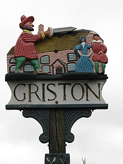
is in folklore the abode of the wicked uncle who ordered the death of his wards, the
431:
1127:
1072:
1037:
1032:
862:
837:
777:
692:
672:
439:
344:
121:
516:
Census population and household counts for unparished urban areas and all parishes
1237:
1187:
1092:
942:
937:
922:
872:
852:
707:
446:, so that he could inherit their property. The village sign reflects the story.
1222:
1122:
1117:
987:
917:
897:
887:
802:
702:
641:
466:
391:
322:
309:
1265:
1077:
1067:
1062:
932:
902:
792:
767:
379:
215:
1177:
1167:
1112:
1107:
1102:
1097:
1002:
927:
832:
787:
752:
611:
554:
458:
395:
1313:
1242:
1137:
1012:
997:
977:
972:
952:
907:
847:
807:
782:
762:
757:
732:
717:
360:
197:
163:
67:
1247:
1017:
947:
817:
772:
415:
418:, where the nearest primary school is Caston CE VA Primary School.
882:
399:
386:, a pub 'The Waggon And Horses', an elderly home 'Thorp House', a
529:"Norfolk Folk Tales – Legends said to have originated in Norfolk"
645:
1321:
469:
and provide a shorter, traffic free alternative to the
638:
http://kepn.nottingham.ac.uk/map/place/Norfolk/Griston
264:
252:
240:
224:
214:
204:
190:
172:
154:
136:
120:
104:
93:
85:
77:
23:
465:. The new route would follow the boundary of the
1341:
657:
8:
535:. Breckland District Council. Archived from
576:"Planning Obligations Monitoring Statement"
1348:
1334:
664:
650:
642:
429:The village can be traced way back to the
20:
605:"Watton and Griston Link Schematic Map"
482:
235:
213:
189:
103:
76:
27:
263:
251:
239:
223:
203:
171:
153:
135:
92:
7:
1302:
1300:
410:, where the nearest high school is
81:5.62 km (2.17 sq mi)
843:Garvestone, Reymerston and Thuxton
14:
1304:
497:. Office for National Statistics
414:and a fellow Wayland village of
52:
45:
29:
388:day care centre for the elderly
378:It has a church in the name of
53:
491:"Civil Parish population 2011"
1:
1320:. You can help Knowledge by
1276:King's Lynn and West Norfolk
438:The local Griston Hall near
406:. It lies between the town
106:OS grid reference
18:Human settlement in England
1398:
1299:
1377:Civil parishes in Norfolk
1256:
683:
551:"Watton and Griston Link"
280:
276:
236:
40:
28:
495:Neighbourhood Statistics
1382:Norfolk geography stubs
1233:Whinburgh and Westfield
1158:Stow Bedon and Breckles
453:Watton and Griston Link
390:, it hosts part of the
100:274/km (710/sq mi)
1316:location article is a
1218:Weeting-with-Broomhill
713:Beeston with Bittering
583:Norfolk County Council
402:), and the category C
398:(now belonging to the
226:Postcode district
1028:Newton by Castle Acre
1208:Weasenham All Saints
1143:Sporle with Palgrave
355:district within the
206:Sovereign state
35:Griston village sign
1367:Villages in Norfolk
1083:Roudham and Larling
404:Wayland (HM Prison)
319: /
1372:Breckland District
1213:Weasenham St Peter
958:Little Cressingham
621:on 21 October 2007
422:History of Griston
1329:
1328:
1294:
1293:
858:Great Cressingham
444:Babes in the Wood
343:is a village and
338:
337:
323:52.558°N 0.8665°E
156:Shire county
89:1,540 (2011)
1389:
1350:
1343:
1336:
1308:
1301:
968:Little Ellingham
913:Hoe and Worthing
666:
659:
652:
643:
631:
630:
628:
626:
620:
614:. Archived from
609:
601:
595:
594:
592:
590:
580:
572:
566:
565:
563:
561:
547:
541:
540:
539:on 4 March 2007.
525:
519:
513:
507:
506:
504:
502:
487:
334:
333:
331:
330:
329:
324:
320:
317:
316:
315:
312:
286:
200:
116:
115:
66:Location within
56:
55:
49:
33:
21:
1397:
1396:
1392:
1391:
1390:
1388:
1387:
1386:
1357:
1356:
1355:
1354:
1297:
1295:
1290:
1252:
1133:South Pickenham
1048:North Tuddenham
1043:North Pickenham
868:Great Ellingham
679:
670:
635:
634:
624:
622:
618:
607:
603:
602:
598:
588:
586:
585:. February 2009
578:
574:
573:
569:
559:
557:
549:
548:
544:
533:Visit Breckland
527:
526:
522:
514:
510:
500:
498:
489:
488:
484:
479:
467:Watton airfield
457:As part of the
455:
424:
412:Wayland Academy
408:Watton, Norfolk
327:
325:
321:
318:
313:
310:
308:
306:
305:
304:
284:
271:East of England
196:
186:
168:
150:
132:
111:
110:
73:
72:
71:
70:
64:
63:
62:
61:
57:
36:
19:
12:
11:
5:
1395:
1393:
1385:
1384:
1379:
1374:
1369:
1359:
1358:
1353:
1352:
1345:
1338:
1330:
1327:
1326:
1309:
1292:
1291:
1289:
1288:
1283:
1278:
1273:
1271:Great Yarmouth
1268:
1263:
1257:
1254:
1253:
1251:
1250:
1245:
1240:
1235:
1230:
1225:
1220:
1215:
1210:
1205:
1200:
1195:
1190:
1185:
1180:
1175:
1173:Swanton Morley
1170:
1165:
1160:
1155:
1150:
1145:
1140:
1135:
1130:
1125:
1120:
1115:
1110:
1105:
1100:
1095:
1090:
1085:
1080:
1075:
1070:
1065:
1060:
1055:
1050:
1045:
1040:
1035:
1030:
1025:
1020:
1015:
1010:
1005:
1000:
995:
990:
985:
980:
975:
970:
965:
960:
955:
950:
945:
940:
935:
930:
925:
920:
915:
910:
905:
900:
895:
890:
885:
880:
875:
870:
865:
860:
855:
850:
845:
840:
835:
830:
825:
820:
815:
813:East Tuddenham
810:
805:
800:
795:
790:
785:
780:
775:
770:
765:
760:
755:
750:
745:
740:
735:
730:
725:
720:
715:
710:
705:
700:
695:
690:
684:
681:
680:
673:Civil parishes
671:
669:
668:
661:
654:
646:
633:
632:
596:
567:
542:
520:
508:
481:
480:
478:
475:
454:
451:
423:
420:
357:English county
336:
335:
328:52.558; 0.8665
303:
302:
297:
292:
287:
285:List of places
281:
278:
277:
274:
273:
268:
262:
261:
256:
250:
249:
244:
238:
237:
234:
233:
228:
222:
221:
218:
212:
211:
210:United Kingdom
208:
202:
201:
194:
188:
187:
185:
184:
178:
176:
170:
169:
167:
166:
160:
158:
152:
151:
149:
148:
142:
140:
134:
133:
131:
130:
126:
124:
118:
117:
108:
102:
101:
98:
91:
90:
87:
83:
82:
79:
75:
74:
65:
59:
58:
51:
50:
44:
43:
42:
41:
38:
37:
34:
26:
25:
17:
13:
10:
9:
6:
4:
3:
2:
1394:
1383:
1380:
1378:
1375:
1373:
1370:
1368:
1365:
1364:
1362:
1351:
1346:
1344:
1339:
1337:
1332:
1331:
1325:
1323:
1319:
1315:
1310:
1307:
1303:
1298:
1287:
1286:South Norfolk
1284:
1282:
1281:North Norfolk
1279:
1277:
1274:
1272:
1269:
1267:
1264:
1262:
1259:
1258:
1255:
1249:
1246:
1244:
1241:
1239:
1236:
1234:
1231:
1229:
1226:
1224:
1221:
1219:
1216:
1214:
1211:
1209:
1206:
1204:
1201:
1199:
1196:
1194:
1191:
1189:
1186:
1184:
1181:
1179:
1176:
1174:
1171:
1169:
1166:
1164:
1161:
1159:
1156:
1154:
1151:
1149:
1146:
1144:
1141:
1139:
1136:
1134:
1131:
1129:
1126:
1124:
1121:
1119:
1116:
1114:
1111:
1109:
1106:
1104:
1101:
1099:
1096:
1094:
1091:
1089:
1086:
1084:
1081:
1079:
1076:
1074:
1071:
1069:
1066:
1064:
1061:
1059:
1056:
1054:
1053:Old Buckenham
1051:
1049:
1046:
1044:
1041:
1039:
1036:
1034:
1031:
1029:
1026:
1024:
1023:New Buckenham
1021:
1019:
1016:
1014:
1011:
1009:
1006:
1004:
1001:
999:
996:
994:
991:
989:
986:
984:
981:
979:
976:
974:
971:
969:
966:
964:
963:Little Dunham
961:
959:
956:
954:
951:
949:
946:
944:
941:
939:
936:
934:
931:
929:
926:
924:
921:
919:
916:
914:
911:
909:
906:
904:
901:
899:
896:
894:
891:
889:
886:
884:
881:
879:
876:
874:
871:
869:
866:
864:
861:
859:
856:
854:
851:
849:
846:
844:
841:
839:
836:
834:
831:
829:
826:
824:
821:
819:
816:
814:
811:
809:
806:
804:
801:
799:
796:
794:
791:
789:
786:
784:
781:
779:
776:
774:
771:
769:
766:
764:
761:
759:
756:
754:
751:
749:
746:
744:
741:
739:
736:
734:
731:
729:
726:
724:
721:
719:
716:
714:
711:
709:
706:
704:
701:
699:
696:
694:
691:
689:
686:
685:
682:
678:
674:
667:
662:
660:
655:
653:
648:
647:
644:
640:
639:
617:
613:
606:
600:
597:
584:
577:
571:
568:
556:
552:
546:
543:
538:
534:
530:
524:
521:
517:
512:
509:
496:
492:
486:
483:
476:
474:
472:
468:
464:
460:
452:
450:
447:
445:
441:
436:
434:
433:
432:Domesday Book
427:
421:
419:
417:
413:
409:
405:
401:
397:
393:
389:
385:
381:
376:
374:
370:
366:
362:
358:
354:
350:
346:
342:
332:
301:
298:
296:
293:
291:
288:
283:
282:
279:
275:
272:
269:
267:
260:
257:
255:
248:
245:
243:
232:
229:
227:
219:
217:
209:
207:
199:
195:
193:
183:
180:
179:
177:
175:
165:
162:
161:
159:
157:
147:
144:
143:
141:
139:
128:
127:
125:
123:
119:
114:
109:
107:
99:
97:
88:
84:
80:
69:
48:
39:
32:
22:
16:
1322:expanding it
1311:
1296:
1260:
1128:South Lopham
1073:Riddlesworth
1038:North Lopham
1033:North Elmham
877:
863:Great Dunham
838:Garboldisham
778:Cockley Cley
693:Attleborough
636:
623:. Retrieved
616:the original
599:
587:. Retrieved
570:
558:. Retrieved
545:
537:the original
532:
523:
511:
499:. Retrieved
494:
485:
456:
448:
440:Wayland Wood
437:
430:
428:
425:
377:
351:area of the
345:civil parish
340:
339:
122:Civil parish
15:
1238:Whissonsett
1188:Tittleshall
1093:Saham Toney
943:Kilverstone
938:Kenninghall
923:Horningtoft
873:Gressenhall
853:Gooderstone
738:Blo' Norton
728:Billingford
708:Beachamwell
365:2001 census
326: /
1361:Categories
1223:Wellingham
1193:Tottington
1123:South Acre
1118:Snetterton
1008:Narborough
988:Mattishall
918:Holme Hale
898:Hilborough
888:Hardingham
803:Didlington
748:Brettenham
703:Bawdeswell
477:References
392:RAF Watton
311:52°33′29″N
86:Population
1266:Broadland
1148:Stanfield
1078:Rocklands
1068:Quidenham
1063:Oxborough
933:Kempstone
903:Hockering
793:Cranworth
768:Carbrooke
743:Bradenham
723:Besthorpe
677:Breckland
380:St. Peter
373:Breckland
353:Breckland
314:0°51′59″E
266:Ambulance
216:Post town
146:Breckland
1261:See also
1228:Wendling
1183:Thompson
1178:Thetford
1168:Swaffham
1163:Sturston
1153:Stanford
1113:Shropham
1108:Shipdham
1103:Scoulton
1098:Scarning
1058:Ovington
1003:Mundford
928:Ickburgh
833:Fransham
788:Cranwich
753:Bridgham
612:Sustrans
555:Sustrans
501:5 August
459:Sustrans
396:airfield
394:wartime
384:St. Paul
369:district
220:THETFORD
138:District
113:TL944994
1314:Norfolk
1243:Wretham
1198:Twyford
1138:Sparham
1088:Rougham
1013:Narford
998:Mileham
978:Lynford
973:Longham
953:Litcham
908:Hockham
893:Harling
878:Griston
848:Gateley
823:Foulden
808:Dereham
798:Croxton
783:Colkirk
763:Bylaugh
758:Brisley
733:Bintree
718:Beetley
361:Norfolk
349:Wayland
347:in the
341:Griston
300:Norfolk
295:England
259:Norfolk
247:Norfolk
198:England
192:Country
164:Norfolk
129:Griston
96:Density
94:•
68:Norfolk
60:Griston
24:Griston
1248:Yaxham
1203:Watton
1018:Necton
993:Merton
948:Lexham
828:Foxley
818:Elsing
773:Caston
698:Banham
688:Ashill
625:7 July
589:7 July
560:7 July
463:Watton
416:Caston
242:Police
174:Region
1312:This
883:Guist
619:(PDF)
608:(PDF)
579:(PDF)
471:A1075
400:USAAF
1318:stub
983:Lyng
627:2009
591:2009
562:2009
503:2016
382:and
254:Fire
231:IP25
182:East
78:Area
675:of
371:of
359:of
1363::
610:.
581:.
553:.
531:.
493:.
435:.
375:.
290:UK
1349:e
1342:t
1335:v
1324:.
665:e
658:t
651:v
629:.
593:.
564:.
505:.
Text is available under the Creative Commons Attribution-ShareAlike License. Additional terms may apply.