426:
38:
116:
414:
438:
83:
402:
53:
63:
123:
90:
659:
372:
In 1639, a little town hall was built in Groet. It claims to be the smallest and oldest town hall of the
Netherlands. The oldest claim is definitely not true, but it may be the smallest.
365:
mill was built in 1890. In 1977, a pumping station was built and the wind mill was decommissioned resulting in a deterioration of the wind mill, therefore, it was decided to drain the
652:
786:
425:
645:
810:
37:
115:
805:
628:
387:
345:
The village was first mentioned between 1130 and 1161 as "in
Grothen", and means "land growth". Groet developed on the boundary of the dunes and the
295:
307:
352:
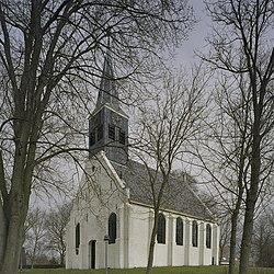
The Dutch
Reformed church is a single aisled church with wooden tower which was built in 1639 and was modified in 1738. In 1830, the
669:
151:
82:
437:
815:
401:
413:
287:
637:
183:
687:
673:
551:
380:
330:
266:
208:
62:
353:
276:
52:
708:
573:
379:. The village was home to 186 people in 1840. In 2001, it became part of the municipality of
467:
713:
703:
799:
718:
326:
198:
369:
both by the mill and the pumping station. Groetermolen is still in active service.
375:
Groet was a separate municipality between 1817 and 1834, when it was merged with
322:
188:
769:
754:
346:
521:
166:
153:
749:
257:
775:
744:
759:
728:
376:
334:
764:
361:
283:
262:
602:
495:
641:
135:
Location in the province of North
Holland in the Netherlands
550:
Ronald
Stenvert & Saskia van Ginkel-Meester (2006).
390:, in 1938 and 1948 respectively, took place in Groet.
787:
List of cities, towns and villages in North
Holland
737:
696:
680:
306:
294:
273:
256:
248:
240:
235:
227:
219:
214:
204:
194:
182:
21:
653:
8:
660:
646:
638:
545:
543:
18:
388:International Youth Congress of Esperanto
356:collapsed and was rebuilt shortly after.
333:, and lies about 11 km northwest of
597:
595:
454:
397:
293:
255:
234:
226:
213:
181:
146:
74:
46:
34:
811:Former municipalities of North Holland
462:
460:
458:
329:. It is a part of the municipality of
629:Repertorium van Nederlandse gemeenten
305:
272:
247:
239:
218:
203:
193:
16:Village in North Holland, Netherlands
7:
468:"Kerncijfers wijken en buurten 2021"
627:Ad van der Meer and Onno Boonstra,
223:3.29 km (1.27 sq mi)
14:
806:Populated places in North Holland
436:
424:
412:
400:
121:
114:
88:
81:
61:
51:
36:
502:(in Dutch). Het Waterschapshuis
500:Actueel Hoogtebestand Nederland
359:The windmill Groetermolen is a
1:
522:"Groet - (geografische naam)"
122:
89:
554:(in Dutch). Zwolle: Waanders
472:Central Bureau of Statistics
102:Location in the Netherlands
832:
784:
496:"Postcodetool for 1873GA"
252:470/km (1,200/sq mi)
231:4.9 m (16.1 ft)
147:
138:Show map of North Holland
75:
47:
35:
28:
668:Populated places in the
105:Show map of Netherlands
816:Bergen, North Holland
674:Bergen, North Holland
407:Windmill Groetermolen
275: • Summer (
42:Dutch Reformed church
483:combined with Hargen
386:The 1st and the 4th
321:is a village in the
249: • Density
709:Egmond aan den Hoef
163: /
241: • Total
220: • Total
793:
792:
316:
315:
823:
662:
655:
648:
639:
632:
625:
619:
618:
616:
614:
599:
590:
589:
587:
585:
570:
564:
563:
561:
559:
547:
538:
537:
535:
533:
518:
512:
511:
509:
507:
492:
486:
485:
480:
478:
464:
443:Former town hall
440:
428:
416:
404:
280:
178:
177:
175:
174:
173:
168:
167:52.717°N 4.667°E
164:
161:
160:
159:
156:
139:
125:
124:
118:
106:
92:
91:
85:
65:
55:
40:
19:
831:
830:
826:
825:
824:
822:
821:
820:
796:
795:
794:
789:
780:
733:
692:
676:
666:
636:
635:
626:
622:
612:
610:
601:
600:
593:
583:
581:
572:
571:
567:
557:
555:
549:
548:
541:
531:
529:
520:
519:
515:
505:
503:
494:
493:
489:
476:
474:
466:
465:
456:
451:
444:
441:
432:
429:
420:
417:
408:
405:
396:
343:
302:
274:
171:
169:
165:
162:
157:
154:
152:
150:
149:
143:
142:
141:
140:
137:
136:
133:
132:
131:
130:
126:
109:
108:
107:
104:
103:
100:
99:
98:
97:
93:
71:
70:
69:
68:
59:
58:
43:
31:
24:
17:
12:
11:
5:
829:
827:
819:
818:
813:
808:
798:
797:
791:
790:
785:
782:
781:
779:
778:
773:
767:
762:
757:
752:
747:
741:
739:
735:
734:
732:
731:
726:
721:
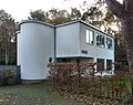
716:
714:Egmond aan Zee
711:
706:
704:Bergen aan Zee
700:
698:
694:
693:
691:
690:
684:
682:
678:
677:
667:
665:
664:
657:
650:
642:
634:
633:
631:, KNAW, 2011.
620:
591:
578:Molen database
574:"Groetermolen"
565:
539:
526:Etymologiebank
513:
487:
453:
452:
450:
447:
446:
445:
442:
435:
433:
430:
423:
421:
418:
411:
409:
406:
399:
395:
392:
342:
339:
314:
313:
310:
304:
303:
300:
298:
292:
291:
281:
271:
270:
260:
254:
253:
250:
246:
245:
242:
238:
237:
233:
232:
229:
225:
224:
221:
217:
216:
212:
211:
206:
202:
201:
196:
192:
191:
186:
180:
179:
145:
144:
134:
128:
127:
120:
119:
113:
112:
111:
110:
101:
95:
94:
87:
86:
80:
79:
78:
77:
76:
73:
72:
66:
60:
56:
50:
49:
48:
45:
44:
41:
33:
32:
29:
26:
25:
22:
15:
13:
10:
9:
6:
4:
3:
2:
828:
817:
814:
812:
809:
807:
804:
803:
801:
788:
783:
777:
774:
771:
768:
766:
763:
761:
758:
756:
753:
751:
748:
746:
743:
742:
740:
736:
730:
727:
725:
722:
720:
719:Egmond-Binnen
717:
715:
712:
710:
707:
705:
702:
701:
699:
695:
689:
686:
685:
683:
679:
675:
671:
663:
658:
656:
651:
649:
644:
643:
640:
630:
624:
621:
608:
604:
598:
596:
592:
579:
575:
569:
566:
553:
546:
544:
540:
527:
523:
517:
514:
501:
497:
491:
488:
484:
473:
469:
463:
461:
459:
455:
448:
439:
434:
431:Farm in Groet
427:
422:
415:
410:
403:
398:
393:
391:
389:
384:
382:
378:
373:
370:
368:
364:
363:
357:
355:
350:
348:
340:
338:
336:
332:
328:
327:North Holland
324:
320:
311:
309:
299:
297:
289:
285:
282:
278:
268:
264:
261:
259:
251:
243:
230:
222:
210:
207:
200:
199:North Holland
197:
190:
187:
185:
176:
172:52.717; 4.667
148:Coordinates:
117:
84:
64:
54:
39:
27:
20:
723:
670:municipality
623:
611:. Retrieved
607:Plaatsengids
606:
582:. Retrieved
577:
568:
556:. Retrieved
530:. Retrieved
525:
516:
504:. Retrieved
499:
490:
482:
475:. Retrieved
471:
385:
374:
371:
366:
360:
358:
351:
344:
325:province of
318:
317:
308:Dialing code
205:Municipality
67:Coat of arms
772:(partially)
296:Postal code
189:Netherlands
170: /
800:Categories
770:Schoorldam
755:Camperduin
609:(in Dutch)
580:(in Dutch)
528:(in Dutch)
449:References
419:Villa Oase
347:raised bog
236:Population
750:Bregtdorp
258:Time zone
228:Elevation
776:Wimmenum
745:Aagtdorp
697:Villages
613:28 April
584:28 April
558:28 April
532:28 April
506:28 April
477:28 April
195:Province
760:Catrijp
738:Hamlets
729:Schoorl
603:"Groet"
552:"Groet"
394:Gallery
377:Schoorl
341:History
335:Alkmaar
184:Country
155:52°43′N
30:Village
765:Hargen
688:Bergen
381:Bergen
367:polder
362:polder
331:Bergen
209:Bergen
158:4°40′E
724:Groet
681:Towns
354:choir
323:Dutch
319:Groet
284:UTC+2
263:UTC+1
244:1,530
129:Groet
96:Groet
23:Groet
615:2022
586:2022
560:2022
534:2022
508:2022
479:2022
301:1873
288:CEST
215:Area
57:Flag
672:of
312:072
277:DST
267:CET
802::
605:.
594:^
576:.
542:^
524:.
498:.
481:.
470:.
457:^
383:.
349:.
337:.
661:e
654:t
647:v
617:.
588:.
562:.
536:.
510:.
290:)
286:(
279:)
269:)
265:(
Text is available under the Creative Commons Attribution-ShareAlike License. Additional terms may apply.