202:
44:
31:
194:
210:
51:
226:. The area had seen a massive population increase as a result of the steel and coal industries but the supply of water to the area was complicated due to its high altitude. A site for a new reservoir was chosen at the head of the Grwyne Fawr valley because at 1725 ft above sea level it was high enough to allow water to be gravity fed to
238:
and hospital. The workmen quarried 200,000 tons of sandstone for the construction of the dam. Large boulders weighing up to 5 tons each were set in concrete to form the dam, which is 130 feet thick at its base, the walls were then faced with dressed stone. A 16-inch diameter steel pipeline was tunnelled through
237:
Work recommenced in
January 1919; the railway was completed and connected to the main line at Llanvihangel Crucorney. A village of construction workers and their families grew in the valley at Blaen-y-cwm. A community of some 300 people lived there with a hostel, canteen, day school, police station
233:
Building works started in 1912, but almost immediately hit problems. The road constructed up the valley could not take the weight of the heavy traction engines used for haulage. It was decided that a new railway would be required, however negotiations with local land owners failed and the line
246:. The dam was finally completed in February 1928, after which the railway and structures that served its construction were quickly dismantled, including the workers’ village. The total cost of construction was reported to be £1 million.
262:, and no longer supplies drinking water. Poor management of the surrounding catchment area has allowed peat sediment to wash into the reservoir, causing water discolouration, and it has proved uneconomical to remedy the problem.
409:
453:
43:
448:
307:
84:
201:
339:
30:
259:
443:
183:
193:
223:
279:
368:
128:
209:
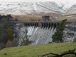
190:. Completed in 1928, it has the capacity to hold 400,000,000 imperial gallons (1,800 megalitres).
410:"The Brecon Beacons National Park: a good place for Glastir Sustainable Land Management Scheme"
222:
By the end of the 19th-century there were serious water shortages in the western parts of the
234:
remained incomplete. With the outbreak of the First World War proceedings were put on hold.
239:
142:
437:
116:
308:"Construction of Grwyne Fawr Dam, Black Mountains, Powys, 1910s – 4 Old Photographs"
340:"The construction of the Grwyne Fawr Waterworks (1913-1928): A Relic at Crosskeys"
255:
227:
179:
135:
243:
99:
86:
121:
129:
208:
200:
192:
187:
164:
156:
152:
141:
127:
115:
76:
68:
23:
213:The Grwyne Fawr Reservoir during the 1976 drought
77:
160:400,000,000 imperial gallons (1,800 megalitres)
454:Reservoirs in the Brecon Beacons National Park
205:View down the Grwyne Fawr valley from the dam
50:
8:
20:
369:"GRWYNE FAWR RESERVOIR (INDUSTRIAL SITE)"
363:
361:
333:
331:
329:
302:
300:
254:The reservoir has been decommissioned by
242:carrying water to a holding reservoir in
449:Industrial archaeological sites in Wales
271:
417:Brecon Beacons National Park Authority
395:Stone and Steam in the Black Mountains
178:is located in the valley of the river
7:
280:"GRWYNE FAWR, RESERVOIR (RESERVOIR)"
18:Reservoir in Brecon Beacons, Wales
14:
224:historic county of Monmouthshire
49:
42:
29:
338:Osborne, Graham (Spring 2005).
163:
155:
1:
408:Paul Sinnadurai (July 2009).
67:
184:Brecon Beacons National Park
393:Tipper, Rev. D. A. (1975).
230:and the surrounding areas.
197:View across Grwyne Fawr dam
470:
37:
28:
168:1,725 feet (526 m)
214:
206:
198:
312:amdally.wordpress.com
212:
204:
196:
176:Grwyne Fawr Reservoir
72:Brecon Beacons, Wales
57:Grwyne Fawr Reservoir
24:Grwyne Fawr Reservoir
100:51.97000°N 3.12056°W
444:Reservoirs in Wales
344:Gwent Local History
96: /
215:
207:
199:
105:51.97000; -3.12056
397:. Blorenge Books.
172:
171:
165:Surface elevation
461:
428:
427:
425:
423:
414:
405:
399:
398:
390:
384:
383:
381:
379:
365:
356:
355:
353:
351:
335:
324:
323:
321:
319:
304:
295:
294:
292:
290:
276:
131:
130:Primary outflows
111:
110:
108:
107:
106:
101:
97:
94:
93:
92:
89:
79:
53:
52:
46:
33:
21:
469:
468:
464:
463:
462:
460:
459:
458:
434:
433:
432:
431:
421:
419:
412:
407:
406:
402:
392:
391:
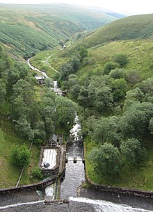
387:
377:
375:
367:
366:
359:
349:
347:
337:
336:
327:
317:
315:
306:
305:
298:
288:
286:
278:
277:
273:
268:
252:
220:
145: countries
104:
102:
98:
95:
90:
87:
85:
83:
82:
64:
63:
62:
61:
60:
59:
58:
54:
19:
12:
11:
5:
467:
465:
457:
456:
451:
446:
436:
435:
430:
429:
400:
385:
357:
325:
314:. 4 April 2013
296:
270:
269:
267:
264:
251:
248:
240:Coity Mountain
219:
216:
170:
169:
166:
162:
161:
158:
154:
153:
150:
149:
148:United Kingdom
146:
139:
138:
133:
125:
124:
119:
113:
112:
80:
74:
73:
70:
66:
65:
56:
55:
48:
47:
41:
40:
39:
38:
35:
34:
26:
25:
17:
13:
10:
9:
6:
4:
3:
2:
466:
455:
452:
450:
447:
445:
442:
441:
439:
418:
411:
404:
401:
396:
389:
386:
374:
370:
364:
362:
358:
345:
341:
334:
332:
330:
326:
313:
309:
303:
301:
297:
285:
281:
275:
272:
265:
263:
261:
260:water company
257:
249:
247:
245:
241:
235:
231:
229:
225:
217:
211:
203:
195:
191:
189:
185:
181:
177:
167:
159:
151:
147:
144:
140:
137:
134:
132:
126:
123:
120:
118:
114:
109:
81:
75:
71:
45:
36:
32:
27:
22:
16:
420:. Retrieved
416:
403:
394:
388:
376:. Retrieved
372:
348:. Retrieved
343:
316:. Retrieved
311:
287:. Retrieved
283:
274:
258:, the local
253:
236:
232:
221:
218:Construction
175:
173:
157:Water volume
15:
346:(98): 63–68
228:Abertillery
180:Grwyne Fawr
136:Grwyne Fawr
103: /
78:Coordinates
438:Categories
266:References
244:Cwmtillery
88:51°58′12″N
256:Dŵr Cymru
250:Operation
122:Reservoir
91:3°7′14″W
69:Location
373:COFLEIN
284:COFLEIN
182:in the
378:10 May
318:10 May
289:10 May
422:9 May
413:(PDF)
350:9 May
188:Wales
143:Basin
424:2016
380:2016
352:2016
320:2016
291:2016
174:The
117:Type
440::
415:.
371:.
360:^
342:.
328:^
310:.
299:^
282:.
186:,
426:.
382:.
354:.
322:.
293:.
Text is available under the Creative Commons Attribution-ShareAlike License. Additional terms may apply.