43:
918:
830:
65:
245:
42:
210:) had a population of 663. The Peruvian government's estimate of the 2017 population of the district was 4,773 of which 77 percent of the population over 12 years of age belonged to what it defined as the
320:
the climate of Huyro is classified as Awbb (tropical savanna, warm year round). Temperatures vary little during the course of the year, although a pronounced dry season occurs from May to
September.
747:
905:
1702:
241:
mountain range traverses the northern border of
Hayopata. The highest peak of the district is Urupampa, also called Veronica. Other mountains are listed below:
898:
874:
1658:
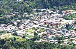
206:. Huyro, the capital of the district had a population of 1,619 in 2017. Nearby Amaybamba (not to be confused with the town of the same name in
1421:
1242:
1411:
1396:
891:
1522:
1285:
317:
230:, (5,893 m (19,334 ft) in elevation, and the mountains on both sides of the valley. The Lucumayo River flows into the
1618:
1280:
1585:
1697:
1570:
725:
672:
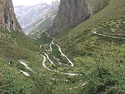
The lower part of the
Lucumayo River is one of the nearest and most accessible tropical areas to the heavily populated
1328:
1184:
1179:
867:
1126:
883:
1363:
199:
94:
755:
1290:
1025:
57:
313:
1540:
1136:
238:
1633:
1318:
1010:
860:
815:
917:
1532:
1464:
1416:
1204:
1078:
962:
710:
1517:
977:
1623:
1502:
1489:
1222:
1111:
803:
1590:
1512:
1507:
1454:
1348:
1237:
1212:
1015:
1000:
967:
227:
109:
82:
1613:
1575:
1550:
1479:
1474:
1406:
1323:
1174:
1169:
1164:
1159:
1020:
1005:
995:
773:
312:
at the lowest elevations. The capital of Huyro has a climate of Aw (tropical savanna) under the
1638:
1605:
1580:
1560:
1391:
1381:
1371:
1343:
1338:
1227:
1088:
972:
705:
207:
195:
89:
51:
to
Huayopata, coming down from Abra Malaga (Pass), 4,333 metres (14,216 ft) in elevation.
33:
696:. Tea was first introduced into Peru as a crop in 1913 near Huyro and is still grown there.
1545:
1401:
1386:
1333:
1310:
1300:
1247:
1217:
1189:
1151:
1141:
1030:
947:
939:
300:
The large variation in elevations in
Huayopata district results in ecosystems ranging from
1555:
1497:
1469:
1459:
1449:
1431:
1295:
1265:
1232:
1131:
1116:
1106:
1035:
952:
759:
685:
77:
260:
1643:
1628:
1595:
1565:
1444:
1439:
1353:
1275:
1270:
1257:
1194:
1098:
1083:
1073:
1068:
1063:
1053:
1045:
844:
231:
223:
211:
1691:
1121:
1058:
987:
957:
673:
587:
48:
924:
282:
172:
715:
327:
Climate data for Huyro, Huayopata, Peru. Elevation: 1,650 metres (5,410 ft)
829:
793:
escale.minedu.gob.pe - UGEL map of the La
Convención Province 1 (Cusco Region)
309:
1673:
1660:
840:
720:
163:
244:
301:
265:
752:
681:
305:
180:
677:
243:
168:
929:
837:
689:
203:
70:
887:
693:
222:
Huayopata district consists of the narrow valley of the
848:
234:at an elevation of 1,173 metres (3,848 ft).
1604:
1531:
1488:
1430:
1362:
1309:
1256:
1203:
1150:
1097:
1044:
986:
938:
179:
162:
154:
146:
141:
133:
125:
120:
108:
100:
88:
76:
56:
21:
248:The town of Huyro is the capital of the district.
748:Instituto Nacional de Estadística e Informática
680:area of Peru. Crops grown near Huyro include
899:
868:
8:
226:, the source of which is the north slope of
906:
892:
884:
875:
861:
323:
18:
1703:Districts of the La Convención Province
737:
178:
161:
140:
132:
129:524.02 km (202.33 sq mi)
119:
107:
99:
55:
39:
308:at the highest elevations to tropical
153:
145:
124:
87:
75:
7:
826:
824:
14:
916:
828:
318:Trewartha climate classification
63:
41:
753:Banco de Información Distrital
116:population: 1,619 (as of 2017)
1:
847:. You can help Knowledge by
137:1,650 m (5,410 ft)
763:. Retrieved April 11, 2008.
516:Mean daily minimum °C (°F)
376:Mean daily maximum °C (°F)
1719:
823:
659:
326:
585:
515:
445:
375:
370:
367:
364:
361:
358:
355:
352:
349:
346:
343:
340:
337:
334:
331:
40:
31:
25:
814:"Tea History of Peru,"
692:, tropical fruits, and
16:District in Cuzco, Peru
817:. accessed 24 Jul 2019
805:, accessed 19 Jul 2019
775:, accessed 26 May 2019
249:
158:9.1/km (24/sq mi)
1674:13.00750°S 72.55694°W
314:Köppen Classification
247:
1698:Peru geography stubs
1679:-13.00750; -72.55694
155: • Density
1670: /
446:Daily mean °C (°F)
228:Veronica (mountain)
194:is one of fourteen
758:2008-04-23 at the
316:system. Under the
250:
192:Huayopata District
147: • Total
126: • Total
47:The road from the
1652:
1651:
856:
855:
802:"Huyro Weather,"
664:
663:
208:Inkawasi District
189:
188:
1710:
1685:
1684:
1682:
1681:
1680:
1675:
1671:
1668:
1667:
1666:
1663:
920:
908:
901:
894:
885:
877:
870:
863:
832:
825:
818:
812:
806:
800:
794:
791:
785:
782:
776:
770:
764:
746:
742:
324:
198:of the province
69:
67:
66:
45:
19:
1718:
1717:
1713:
1712:
1711:
1709:
1708:
1707:
1688:
1687:
1678:
1676:
1672:
1669:
1664:
1661:
1659:
1657:
1656:
1655:
1653:
1648:
1600:
1527:
1484:
1426:
1358:
1305:
1252:
1199:
1146:
1093:
1040:
982:
934:
912:
882:
881:
822:
821:
813:
809:
801:
797:
792:
788:
783:
779:
771:
767:
760:Wayback Machine
744:
743:
739:
734:
702:
670:
665:
654:
649:
644:
639:
634:
629:
624:
619:
614:
609:
604:
599:
594:
580:
575:
570:
565:
560:
555:
550:
545:
540:
535:
530:
525:
520:
510:
505:
500:
495:
490:
485:
480:
475:
470:
465:
460:
455:
450:
440:
435:
430:
425:
420:
415:
410:
405:
400:
395:
390:
385:
380:
298:
293:
254:Inka Tampu Urqu
220:
214:ethnic group.
115:
104:January 2, 1857
64:
62:
52:
36:
27:
24:
17:
12:
11:
5:
1716:
1714:
1706:
1705:
1700:
1690:
1689:
1650:
1649:
1647:
1646:
1641:
1636:
1631:
1626:
1621:
1616:
1610:
1608:
1602:
1601:
1599:
1598:
1593:
1588:
1583:
1578:
1573:
1568:
1563:
1558:
1553:
1548:
1543:
1541:Andahuaylillas
1537:
1535:
1529:
1528:
1526:
1525:
1520:
1515:
1510:
1505:
1500:
1494:
1492:
1486:
1485:
1483:
1482:
1477:
1472:
1467:
1462:
1457:
1452:
1447:
1442:
1436:
1434:
1428:
1427:
1425:
1424:
1419:
1414:
1409:
1404:
1399:
1394:
1389:
1384:
1379:
1374:
1368:
1366:
1360:
1359:
1357:
1356:
1351:
1346:
1341:
1336:
1331:
1326:
1321:
1315:
1313:
1307:
1306:
1304:
1303:
1298:
1293:
1288:
1283:
1278:
1273:
1268:
1262:
1260:
1254:
1253:
1251:
1250:
1245:
1240:
1235:
1230:
1225:
1220:
1215:
1209:
1207:
1201:
1200:
1198:
1197:
1192:
1187:
1182:
1177:
1172:
1167:
1162:
1156:
1154:
1148:
1147:
1145:
1144:
1139:
1134:
1129:
1124:
1119:
1114:
1109:
1103:
1101:
1095:
1094:
1092:
1091:
1086:
1081:
1076:
1071:
1066:
1061:
1056:
1050:
1048:
1042:
1041:
1039:
1038:
1033:
1028:
1023:
1018:
1013:
1008:
1003:
998:
992:
990:
984:
983:
981:
980:
975:
970:
965:
960:
955:
950:
944:
942:
936:
935:
933:
932:
927:
921:
913:
911:
910:
903:
896:
888:
880:
879:
872:
865:
857:
854:
853:
833:
820:
819:
807:
795:
786:
777:
765:
736:
735:
733:
730:
729:
728:
723:
718:
713:
708:
701:
698:
669:
666:
662:
661:
657:
656:
651:
646:
641:
636:
631:
626:
621:
616:
611:
606:
601:
596:
591:
583:
582:
577:
572:
567:
562:
557:
552:
547:
542:
537:
532:
527:
522:
517:
513:
512:
507:
502:
497:
492:
487:
482:
477:
472:
467:
462:
457:
452:
447:
443:
442:
437:
432:
427:
422:
417:
412:
407:
402:
397:
392:
387:
382:
377:
373:
372:
369:
366:
363:
360:
357:
354:
351:
348:
345:
342:
339:
336:
333:
329:
328:
322:
297:
294:
292:
291:
288:
285:
280:
277:
274:
271:
268:
263:
258:
255:
251:
232:Urubamba River
224:Lucumayo River
219:
216:
187:
186:
183:
177:
176:
166:
160:
159:
156:
152:
151:
148:
144:
143:
139:
138:
135:
131:
130:
127:
123:
122:
118:
117:
112:
106:
105:
102:
98:
97:
92:
86:
85:
80:
74:
73:
60:
54:
53:
46:
38:
37:
32:
29:
28:
22:
15:
13:
10:
9:
6:
4:
3:
2:
1715:
1704:
1701:
1699:
1696:
1695:
1693:
1686:
1683:
1645:
1642:
1640:
1637:
1635:
1634:Ollantaytambo
1632:
1630:
1627:
1625:
1622:
1620:
1617:
1615:
1612:
1611:
1609:
1607:
1603:
1597:
1594:
1592:
1589:
1587:
1584:
1582:
1579:
1577:
1574:
1572:
1569:
1567:
1564:
1562:
1559:
1557:
1554:
1552:
1549:
1547:
1544:
1542:
1539:
1538:
1536:
1534:
1530:
1524:
1521:
1519:
1516:
1514:
1511:
1509:
1506:
1504:
1501:
1499:
1496:
1495:
1493:
1491:
1487:
1481:
1478:
1476:
1473:
1471:
1468:
1466:
1463:
1461:
1458:
1456:
1453:
1451:
1448:
1446:
1443:
1441:
1438:
1437:
1435:
1433:
1429:
1423:
1420:
1418:
1415:
1413:
1410:
1408:
1405:
1403:
1400:
1398:
1395:
1393:
1390:
1388:
1385:
1383:
1380:
1378:
1375:
1373:
1370:
1369:
1367:
1365:
1364:La Convención
1361:
1355:
1352:
1350:
1347:
1345:
1342:
1340:
1337:
1335:
1332:
1330:
1327:
1325:
1322:
1320:
1319:Alto Pichigua
1317:
1316:
1314:
1312:
1308:
1302:
1299:
1297:
1294:
1292:
1289:
1287:
1286:San Sebastian
1284:
1282:
1279:
1277:
1274:
1272:
1269:
1267:
1264:
1263:
1261:
1259:
1255:
1249:
1246:
1244:
1241:
1239:
1236:
1234:
1231:
1229:
1226:
1224:
1221:
1219:
1216:
1214:
1211:
1210:
1208:
1206:
1202:
1196:
1193:
1191:
1188:
1186:
1183:
1181:
1178:
1176:
1173:
1171:
1168:
1166:
1163:
1161:
1158:
1157:
1155:
1153:
1149:
1143:
1140:
1138:
1135:
1133:
1130:
1128:
1125:
1123:
1120:
1118:
1115:
1113:
1110:
1108:
1105:
1104:
1102:
1100:
1096:
1090:
1087:
1085:
1082:
1080:
1077:
1075:
1072:
1070:
1067:
1065:
1062:
1060:
1057:
1055:
1052:
1051:
1049:
1047:
1043:
1037:
1034:
1032:
1029:
1027:
1024:
1022:
1019:
1017:
1014:
1012:
1011:Chinchaypujio
1009:
1007:
1004:
1002:
999:
997:
994:
993:
991:
989:
985:
979:
976:
974:
971:
969:
966:
964:
961:
959:
956:
954:
951:
949:
946:
945:
943:
941:
937:
931:
928:
926:
923:Districts of
922:
919:
915:
914:
909:
904:
902:
897:
895:
890:
889:
886:
878:
873:
871:
866:
864:
859:
858:
852:
850:
846:
843:article is a
842:
839:
834:
831:
827:
816:
811:
808:
804:
799:
796:
790:
787:
781:
778:
774:
769:
766:
762:
761:
757:
754:
749:
741:
738:
731:
727:
724:
722:
719:
717:
714:
712:
709:
707:
704:
703:
699:
697:
695:
691:
688:(chocolate),
687:
683:
679:
675:
674:Sacred Valley
667:
658:
652:
647:
642:
637:
632:
627:
622:
617:
612:
607:
602:
597:
592:
589:
588:precipitation
584:
578:
573:
568:
563:
558:
553:
548:
543:
538:
533:
528:
523:
518:
514:
508:
503:
498:
493:
488:
483:
478:
473:
468:
463:
458:
453:
448:
444:
438:
433:
428:
423:
418:
413:
408:
403:
398:
393:
388:
383:
378:
374:
330:
325:
321:
319:
315:
311:
307:
303:
295:
289:
286:
284:
281:
278:
275:
272:
269:
267:
264:
262:
259:
256:
253:
252:
246:
242:
240:
235:
233:
229:
225:
217:
215:
213:
209:
205:
201:
200:La Convención
197:
193:
184:
182:
174:
170:
167:
165:
157:
149:
136:
128:
113:
111:
103:
96:
95:La Convención
93:
91:
84:
81:
79:
72:
61:
59:
50:
49:Sacred Valley
44:
35:
30:
20:
1654:
1619:Huayllabamba
1533:Quispicanchi
1465:Paccaritambo
1417:Santa Teresa
1376:
1281:San Jerónimo
1205:Chumbivilcas
1079:San Salvador
963:Mosoc Llacta
925:Cusco Region
849:expanding it
835:
810:
798:
789:
784:Google Earth
780:
772:"Huaypata,"
768:
751:
745:(in Spanish)
740:
671:
590:mm (inches)
299:
283:Waqay Willka
276:Sara Sarayuq
261:K'urkur Urqu
257:Kuntur Sinqa
236:
221:
191:
190:
1677: /
1624:Machupicchu
1523:Paucartambo
1503:Challabamba
1490:Paucartambo
1243:Santo Tomás
1223:Colquemarca
1137:Túpac Amaru
1112:Kunturkanki
304:and arctic
273:Qillwaqucha
1692:Categories
1665:72°33′25″W
1662:13°00′27″S
1591:Quiquijana
1513:Huancarani
1508:Colquepata
1455:Huanoquite
1422:Vilcabamba
1349:Suykutambo
1213:Capacmarca
1127:Pampamarca
1016:Huarocondo
968:Pomacanchi
732:References
726:Wamanmarka
711:Inka Tampu
310:rainforest
279:Tunki Urqu
142:Population
1614:Chinchero
1576:Marcapata
1551:Ccarhuayo
1518:Kosñipata
1480:Yaurisque
1475:Pillpinto
1412:Santa Ana
1407:Quellouno
1377:Huayopata
1329:Coporaque
1324:Condoroma
1185:San Pedro
1180:San Pablo
1175:Pitumarca
1170:Marangani
1165:Combapata
1160:Checacupe
1026:Mollepata
1021:Limatambo
1006:Cachimayo
996:Ancahuasi
978:Sangarará
841:geography
721:Quchapata
716:Luq'umayu
706:Allpamayu
660:Source:
287:Yana Urqu
270:P'unquyuq
218:Geography
196:districts
164:Time zone
134:Elevation
23:Huayopata
1639:Urubamba
1606:Urubamba
1581:Ocongate
1561:Cusipata
1397:Ocobamba
1392:Maranura
1382:Inkawasi
1372:Echarate
1344:Pichigua
1339:Pallpata
1291:Santiago
1228:Livitaca
1089:Yanatile
973:Rondocan
838:Peruvian
756:Archived
700:See also
586:Average
302:glaciers
290:Yanantin
239:Urupampa
90:Province
34:District
26:Wayupata
1586:Oropesa
1546:Camanti
1402:Pichari
1387:Kimbiri
1334:Ocoruro
1311:Espinar
1301:Wanchaq
1248:Velille
1238:Quiñota
1218:Chamaca
1190:Sicuani
1152:Canchis
1142:Yanaoca
1031:Pucyura
948:Acomayo
940:Acomayo
668:Economy
655:(55.9)
581:(56.0)
576:(57.2)
571:(58.3)
566:(58.3)
561:(55.8)
556:(54.9)
551:(53.2)
546:(52.7)
541:(54.1)
536:(56.5)
531:(56.8)
526:(57.2)
521:(57.0)
511:(70.2)
506:(69.6)
501:(71.8)
496:(72.7)
491:(69.6)
486:(70.5)
481:(69.6)
476:(70.5)
471:(68.4)
466:(69.6)
461:(71.1)
456:(69.6)
451:(69.8)
441:(84.2)
436:(82.2)
431:(85.3)
426:(87.3)
421:(83.5)
416:(86.4)
411:(83.7)
406:(84.0)
401:(85.1)
396:(85.6)
391:(82.6)
386:(82.2)
381:(82.6)
296:Climate
266:Marquni
212:Quechua
110:Capital
101:Founded
58:Country
1556:Ccatca
1498:Caicay
1470:Paruro
1460:Omacha
1450:Colcha
1432:Paruro
1296:Saylla
1266:Ccorca
1233:Llusco
1132:Quehue
1117:Langui
1107:Checca
1036:Zurite
953:Acopia
682:coffee
650:(7.5)
645:(4.8)
640:(4.1)
635:(2.6)
630:(1.6)
625:(1.2)
620:(1.0)
615:(1.7)
610:(4.8)
605:(8.4)
600:(9.2)
595:(9.0)
332:Month
306:tundra
185:080903
181:UBIGEO
78:Region
68:
1644:Yucay
1629:Maras
1596:Urcos
1571:Lucre
1566:Huaro
1445:Ccapi
1440:Accha
1354:Yauri
1276:Poroy
1271:Cusco
1258:Cusco
1195:Tinta
1099:Canas
1084:Taray
1074:Pisac
1069:Lares
1064:Lamay
1054:Calca
1046:Calca
836:This
686:cacao
678:Cusco
653:1,421
371:Year
169:UTC-5
150:4,773
114:Huyro
83:Cuzco
1122:Layo
1059:Coya
1001:Anta
988:Anta
958:Acos
930:Peru
845:stub
690:coca
676:and
579:13.3
574:14.0
569:14.6
564:14.6
559:13.2
554:12.7
549:11.8
544:11.5
539:12.3
534:13.6
529:13.8
524:14.0
519:13.9
509:21.2
504:20.9
499:22.1
494:22.6
489:20.9
484:21.4
479:20.9
474:21.4
469:20.2
464:20.9
459:21.7
454:20.9
449:21.0
439:29.0
434:27.9
429:29.6
424:30.7
419:28.6
414:30.2
409:28.7
404:28.9
399:29.5
394:29.8
389:28.1
384:27.9
379:28.1
368:Dec
365:Nov
362:Oct
359:Sep
356:Aug
353:Jul
350:Jun
347:May
344:Apr
341:Mar
338:Feb
335:Jan
237:The
204:Peru
121:Area
71:Peru
694:tea
648:190
643:123
638:104
608:121
603:214
598:233
593:228
202:in
173:PET
1694::
750:.
684:,
633:67
628:41
623:30
618:26
613:44
907:e
900:t
893:v
876:e
869:t
862:v
851:.
175:)
171:(
Text is available under the Creative Commons Attribution-ShareAlike License. Additional terms may apply.