59:
281:
66:
39:
297:
council, established in 1840, disestablished in 1843, and revived in 1852. From
November 1952, the "Act to appoint District Councils" meant that other townships and urban centres within the hundred started formed local government bodies, with the new district councils of
430:
254:
in 1846. It is 106 square miles (270 km); close to but not exactly one hundred square miles as with most of the other hundreds. Its north boundary is the
156:
139:
58:
315:
91:
349:
228:
529:
501:
344:
311:
303:
333:
457:
318:
had been established as an enclave inside East
Torrens council, bringing the whole of the hundred under local government.
307:
231:
403:
399:
84:
391:
299:
407:
247:
383:
387:
182:
165:
44:
280:
246:, and was one of the first hundreds to be proclaimed. Like the city it surrounds, the Hundred was named after
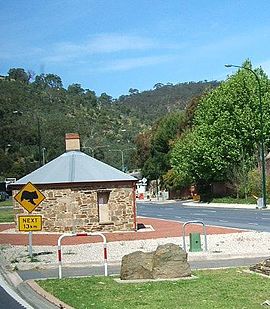
395:
269:
The
Hundred of Adelaide includes all of Adelaide's metropolitan area south of the Torrens and north of the
379:
190:
453:
413:
373:
259:
339:
207:
202:
197:
243:
144:
417:
274:
175:
170:
354:
325:
294:
364:
29:
369:
263:
251:
523:
359:
329:
255:
239:
270:
454:"Property Location Browser: Search for 'Hundred of Adelaide' (ID: SA0000279)"
106:
93:
38:
235:
310:
in the west being established by May 1853. By July of the same year the
483:
321:
The modern local government areas within the
Hundred of Adelaide are:
293:
The first local government body in the
Hundred of Adelaide was the
279:
262:
forms the south east boundary, with the hundred extending to the
273:, with those inner suburbs north of the Torrens falling in the
461:
138:
130:
122:
83:
23:
431:Lands administrative divisions of South Australia
151:
8:
242:. It is one of the eleven hundreds of the
37:
20:
502:"South Australia hundred maps (Adelaide)"
314:had been established in the west and the
316:Corporate Town of Kensington and Norwood
238:spanning all the inner suburbs south of
442:
47:, at roughly the centre of the hundred
448:
446:
284:Plan of the Hundred of Adelaide, 1873
195:
180:
163:
153:
7:
345:City of Norwood Payneham St Peters
14:
504:. Surveyor General's Office. 1959
134:270 km (106 sq mi)
490:. National Library of Australia.
416:(small coastal portion south of
312:District Council of West Torrens
65:
64:
57:
157:Lands administrative divisions
1:
458:Government of South Australia
250:, and was named by Governor
18:Cadastral in South Australia
530:Hundreds of South Australia
546:
488:The New atlas of Australia
213:
154:
150:
52:
36:
380:Adelaide Hills Council
285:
107:34.96611°S 138.61750°E
414:City of Charles Sturt
283:
484:"County of Adelaide"
350:City of Campbelltown
340:City of West Torrens
112:-34.96611; 138.61750
43:The Old Toll House,
225:Hundred of Adelaide
103: /
464:on 7 December 2015
382:(portions west of
286:
264:Adelaide foothills
244:County of Adelaide
418:Henley Beach Road
372:(portion east of
275:Hundred of Yatala
221:
220:
217:
216:
537:
514:
513:
511:
509:
498:
492:
491:
480:
474:
473:
471:
469:
460:. Archived from
450:
355:City of Burnside
326:City of Adelaide
306:in the east and
295:City of Adelaide
289:Local government
159:around Adelaide:
152:
118:
117:
115:
114:
113:
108:
104:
101:
100:
99:
96:
68:
67:
61:
41:
32:
26:
21:
545:
544:
540:
539:
538:
536:
535:
534:
520:
519:
518:
517:
507:
505:
500:
499:
495:
482:
481:
477:
467:
465:
452:
451:
444:
439:
427:
365:City of Mitcham
332:, so excluding
291:
234:in the city of
126:29 October 1846
111:
109:
105:
102:
97:
94:
92:
90:
89:
79:
78:
77:
76:
75:
74:
73:
69:
48:
30:South Australia
28:
27:
24:
19:
12:
11:
5:
543:
541:
533:
532:
522:
521:
516:
515:
493:
475:
441:
440:
438:
435:
434:
433:
426:
423:
422:
421:
411:
377:
370:City of Marion
367:
362:
357:
352:
347:
342:
337:
334:North Adelaide
328:(south of the
302:in the south,
290:
287:
252:Frederick Robe
248:Queen Adelaide
219:
218:
215:
214:
211:
210:
205:
200:
194:
193:
188:
185:
179:
178:
173:
168:
162:
161:
148:
147:
142:
136:
135:
132:
128:
127:
124:
120:
119:
87:
81:
80:
71:
70:
63:
62:
56:
55:
54:
53:
50:
49:
42:
34:
33:
17:
13:
10:
9:
6:
4:
3:
2:
542:
531:
528:
527:
525:
503:
497:
494:
489:
485:
479:
476:
463:
459:
455:
449:
447:
443:
436:
432:
429:
428:
424:
419:
415:
412:
409:
405:
401:
397:
393:
389:
385:
381:
378:
375:
371:
368:
366:
363:
361:
360:City of Unley
358:
356:
353:
351:
348:
346:
343:
341:
338:
335:
331:
327:
324:
323:
322:
319:
317:
313:
309:
305:
301:
296:
288:
282:
278:
276:
272:
267:
265:
261:
257:
256:Torrens River
253:
249:
245:
241:
240:River Torrens
237:
233:
230:
226:
212:
209:
206:
204:
201:
199:
196:
192:
189:
186:
184:
183:Port Adelaide
181:
177:
174:
172:
169:
167:
166:Port Adelaide
164:
160:
158:
149:
146:
143:
141:
137:
133:
129:
125:
121:
116:
88:
86:
82:
60:
51:
46:
40:
35:
31:
22:
16:
506:. Retrieved
496:
487:
478:
466:. Retrieved
462:the original
320:
304:East Torrens
292:
268:
224:
222:
155:
15:
404:Cherryville
400:Marble Hill
374:Sturt Creek
271:Sturt River
260:Sturt River
191:Onkaparinga
123:Established
110: /
98:138°37′03″E
85:Coordinates
437:References
392:Summertown
95:34°57′58″S
408:Montacute
308:Hindmarsh
229:cadastral
208:Noarlunga
203:Noarlunga
198:Noarlunga
524:Category
508:15 April
468:15 April
425:See also
384:Stirling
258:and the
236:Adelaide
187:Adelaide
145:Adelaide
72:Adelaide
25:Adelaide
388:Crafers
330:Torrens
300:Mitcham
232:hundred
45:Urrbrae
396:Ashton
176:Yatala
171:Yatala
140:County
420:only)
410:only)
376:only)
227:is a
510:2016
470:2016
406:and
223:The
131:Area
526::
486:.
456:.
445:^
402:,
398:,
394:,
390:,
386:,
277:.
266:.
512:.
472:.
336:)
Text is available under the Creative Commons Attribution-ShareAlike License. Additional terms may apply.