20:
250:
242:
70:
398:
275:
161:
165:
121:
89:
until it meets with the
Musconetcongs. It is generally unmarred as a plateau, excluding some of the small valleys of tributaries along the Delaware, of
408:
28:
193:
229:
403:
173:
117:
393:
184:
townships. Because of the soil types and relatively flat terrain on the plateau, there are still many farms across the area.
169:
132:
also rises above the rest of the plateau. There are numerous cliffs along the
Delaware where the plateau meets it such as
177:
153:
354:
181:
157:
125:
109:
which form southeastward extensions to the plateau due to a valley of Walnut Brook and the curve of the plateau there.
43:
330:
86:
201:
149:
145:
82:
78:
225:
51:
19:
137:
211:
141:
264:
290:
94:
90:
112:
This also occurs between
Lockatong Valley and the Delaware River. A small ridge called
309:
New Jersey
Geographical Survey. "Final Report, Volume 4". University of Michigan, 1808
55:
208:-speaking Paul Henri Mallet-Prevost, with numerous galleries, restaurants and lodgings
387:
59:
232:, with a spa and a few restaurants and the southern end of the Capoolong Creek Trail
69:
205:
63:
249:
27:
192:
47:
369:
356:
241:
318:
334:
140:
grow, a rarity in
Hunterdon County. The plateau includes the boroughs of
222:, Milford sits along the Delaware with a handful of shops and restaurants
39:
73:
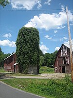
Barn along the
Capoolong Trail and Kingstown Road Hunterdon Plateau
248:
240:
191:
124:
rises slightly above the rest of the plateau. Another feature in
68:
26:
18:
204:, a borough on the banks of the Delaware named after
85:. From there it follows a curved path west of the
23:Topographic map depicting the Hunterdon Plateau
62:to the south and the lower lying areas of the
8:
245:Thomas F. Breden Preserve at Milford Bluffs
399:Landforms of Hunterdon County, New Jersey
302:
218:(after a mill burned down in 1769) and
77:The plateau's edge follows a line from
7:
148:, as well as part of the borough of
14:
196:Race Street Alley in Frenchtown
228:, a small village named after
1:
409:Plateaus of the United States
281:Phillips Farm- pick your own
272:Oak Summit School, Kingwood
258:Bridge Street in Frenchtown
214:, a borough earlier called
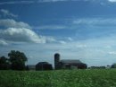
31:Farm in Alexandria Township
425:
319:Preserve at Milford Bluffs
87:South Branch Raritan River
16:Plateau in New Jersey, US
50:. It borders the higher
404:Landforms of New Jersey
254:
246:
197:
101:. Other features are
99:Capoolong Creek Valley
74:
54:to the northwest, the
32:
24:
394:Regions of New Jersey
370:40.59857°N 75.10700°W
261:Capoolong Creek Trail
252:
244:
195:
72:
52:Musconetcong Mountain
30:
22:
331:"Best of Milford NJ"
188:Towns on the plateau
375:40.59857; -75.10700
366: /
265:D&R Canal Trail
255:
247:
198:
138:prickly pear cacti
75:
33:
25:
291:Volendam Windmill
253:Volendam Windmill
237:Sites of interest
95:Wickecheoke Creek
36:Hunterdon Plateau
416:
381:
380:
378:
377:
376:
371:
367:
364:
363:
362:
359:
346:
345:
343:
342:
333:. Archived from
327:
321:
316:
310:
307:
287:Ship Inn Brewery
276:Old Stone Church
126:Holland Township
44:Hunterdon County
424:
423:
419:
418:
417:
415:
414:
413:
384:
383:
374:
372:
368:
365:
360:
357:
355:
353:
352:
350:
349:
340:
338:
329:
328:
324:
317:
313:
308:
304:
299:
239:
190:
103:Thatcher's Hill
97:and Cakepoulin/
91:Lopatcong Creek
17:
12:
11:
5:
422:
420:
412:
411:
406:
401:
396:
386:
385:
348:
347:
322:
311:
301:
300:
298:
295:
294:
293:
288:
285:
284:Schick Reserve
282:
279:
273:
270:
269:Milford Bluffs
267:
262:
259:
238:
235:
234:
233:
223:
209:
189:
186:
134:Milford Bluffs
122:Union Township
56:Delaware River
15:
13:
10:
9:
6:
4:
3:
2:
421:
410:
407:
405:
402:
400:
397:
395:
392:
391:
389:
382:
379:
337:on 2010-02-10
336:
332:
326:
323:
320:
315:
312:
306:
303:
296:
292:
289:
286:
283:
280:
277:
274:
271:
268:
266:
263:
260:
257:
256:
251:
243:
236:
231:
227:
224:
221:
217:
213:
210:
207:
203:
200:
199:
194:
187:
185:
183:
179:
175:
171:
167:
163:
159:
155:
152:and parts of
151:
147:
143:
139:
135:
131:
127:
123:
119:
116:runs through
115:
110:
108:
104:
100:
96:
92:
88:
84:
80:
71:
67:
66:to the east.
65:
61:
60:Amwell Valley
58:to the west,
57:
53:
49:
45:
41:
37:
29:
21:
351:
339:. Retrieved
335:the original
325:
314:
305:
230:William Pitt
219:
215:
206:Swiss French
133:
129:
114:Barren Ridge
113:
111:
106:
102:
98:
76:
64:Newark Basin
35:
34:
373: /
216:Burnt Mills
130:Gravel Hill
42:in western
388:Categories
361:75°06′25″W
358:40°35′55″N
341:2010-01-31
297:References
278:, Kingwood
202:Frenchtown
174:Alexandria
150:Flemington
146:Frenchtown
118:Alexandria
83:Flemington
79:Raven Rock
48:New Jersey
226:Pittstown
170:Bethlehem
107:Sand Hill
220:Millford
178:Delaware
162:Franklin
154:Kingwood
212:Milford
182:Holland
158:Raritan
142:Milford
128:called
40:plateau
180:, and
136:where
166:Union
38:is a
144:and
120:and
105:and
93:and
81:to
390::
176:,
172:,
168:,
164:,
160:,
156:,
46:,
344:.
Text is available under the Creative Commons Attribution-ShareAlike License. Additional terms may apply.