57:
41:
308:
64:
56:
327:
88:
142:
40:
332:
255:
266:. Murtaza peak is 5,100 m just behind K6 base camp and is considered the epicenter of trekkers and beginners.
312:
163:
130:
173:
224:
147:
135:
270:
193:
321:
263:
259:
210:
236:
228:
232:
103:
90:
251:
154:
307:
290:
123:
240:
220:
180:
159:
244:
269:
There are many sub-valleys in the area, including
Gondogor (see
254:
range, including several peaks above six thousands meters like
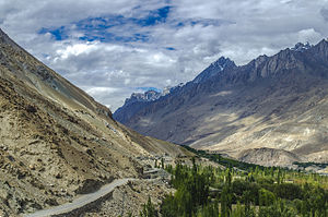
250:
The valley is known for the surrounding high mountains of the
235:
Mountain (at 7,821 meters) and nearby glaciers south to the
204:
170:
153:
141:
129:
119:
21:
8:
227:, Gilgit-Baltistan, Pakistan. Formed by the
273:), Charkusa, Nagma, Nanbroq and Mashabrum.
215:
18:
197:
282:
152:
118:
83:
49:
37:
169:
140:
128:
7:
63:
16:Valley in Gilgit-Baltistan, Pakistan
214:
247:lies in the center of the valley.
14:
306:
62:
55:
39:
1:
205:
328:Valleys of Gilgit-Baltistan
349:
45:Road in lower Hushe Valley
84:
50:
38:
31:
25:
231:, the valley runs from
315:at Wikimedia Commons
172: • Summer (
104:35.47139°N 76.35333°E
76:Location in Pakistan
131:Administrative unit
100: /
109:35.47139; 76.35333
311:Media related to
203:
187:
186:
340:
333:Ghanche District
310:
295:
294:
287:
225:Ghanche District
218:
217:
208:
202:romanized:
201:
199:
177:
136:Gilgit-Baltistan
115:
114:
112:
111:
110:
105:
101:
98:
97:
96:
93:
66:
65:
59:
43:
19:
348:
347:
343:
342:
341:
339:
338:
337:
318:
317:
304:
299:
298:
291:"Hushey valley"
289:
288:
284:
279:
171:
108:
106:
102:
99:
94:
91:
89:
87:
86:
80:
79:
78:
77:
74:
73:
72:
71:
67:
46:
34:
27:
24:
17:
12:
11:
5:
346:
344:
336:
335:
330:
320:
319:
303:
302:External links
300:
297:
296:
281:
280:
278:
275:
271:Gondogoro Pass
185:
184:
178:
168:
167:
157:
151:
150:
145:
139:
138:
133:
127:
126:
121:
117:
116:
82:
81:
75:
69:
68:
61:
60:
54:
53:
52:
51:
48:
47:
44:
36:
35:
32:
29:
28:
22:
15:
13:
10:
9:
6:
4:
3:
2:
345:
334:
331:
329:
326:
325:
323:
316:
314:
309:
301:
292:
286:
283:
276:
274:
272:
267:
265:
261:
257:
253:
248:
246:
245:Hushe village
242:
238:
234:
230:
226:
222:
212:
207:
206:Hūshe lung ma
195:
191:
182:
179:
175:
165:
161:
158:
156:
149:
146:
144:
137:
134:
132:
125:
122:
113:
85:Coordinates:
58:
42:
30:
20:
313:Hushe Valley
305:
285:
268:
249:
198:ཧཱུཥེ་ལུང་མ།
190:Hushe Valley
189:
188:
70:Hushe Valley
26:ཧཱུཥེ་ལུང་མ།
23:Hushe Valley
239:, opposite
237:Shyok River
229:Hushe River
107: /
322:Categories
277:References
256:Laila Peak
233:Masherbrum
95:76°21′12″E
92:35°28′17″N
252:Karakoram
216:وادی ہوشے
155:Time zone
143:District
124:Pakistan
219:) is a
183:(GMT+6)
148:Ghanche
120:Country
262:, and
241:Khaplu
221:valley
33:Valley
194:Balti
181:UTC+6
160:UTC+5
211:Urdu
223:in
174:DST
164:PST
324::
264:K7
260:K6
258:,
243:.
213::
209:;
200:,
196::
293:.
192:(
176:)
166:)
162:(
Text is available under the Creative Commons Attribution-ShareAlike License. Additional terms may apply.