247:
95:
84:
65:
102:
The three whaling stations, Husvik, Stromness, and Leith, were linked by a rough track along the beach. During the whaling era, whalers from
Stromness and Husvik would use it to get to Leith Harbour to use the cinema. The track can still be used, but in some places is rendered impassable by
135:
In the southern summer of 2005/6, the South
Georgia Heritage Trust hired a team of Norwegian craftsmen to restore some of the buildings at Husvik. In March 2006, the Manager's Villa, a building known as the "Radio Shack", and a small generator shed were successfully repaired and restored.
57:. Husvik initially began as a floating, offshore factory site in 1907. In 1910, a land station was constructed and remained operational until 1930; business resumed again between 1945 and 1960. Husvik Harbour was also the site of the third introduction of
776:
234:
129:. Visitors must stay 200 m (656 ft) from the buildings and structures. Access to the Managers' Villa was prohibited in 2011 when the boundary of the 200m Prohibited Area was formalised in legislation.
292:
339:
317:
282:
277:
227:
302:
297:
220:
287:
132:
The jetty is within the 200 m (656 ft) 'danger area' so is not usable, and is in a very dilapidated state. A colony of blue-eyed shags nests on its end each year.
252:
125:, the whaling station has been declared by the South Georgia Government as being too dangerous to visit, due to the danger from collapsing buildings and
212:
522:
183:
114:
used the whaling managers' villa as a temporary shelter when doing work in the area until the mid-1990s. More recent inhabitants include the
604:
715:
446:
740:
476:
451:
28:
481:
436:
426:
360:
175:
431:
344:
58:
50:
456:
400:
111:
76:
118:
expedition of
December 2003, who used it as a base camp for a number of scientific and exploratory projects.
307:
599:
486:
405:
329:
42:
466:
395:
122:
32:
730:
545:
461:
312:
94:
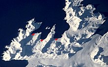
83:
577:
559:
532:
380:
263:
110:
in 1960, and whaling operations at Husvik permanently ceased. Afterwards, scientists from the
690:
540:
115:
665:
660:
655:
629:
491:
421:
103:
aggressively territorial fur seals during their breeding season (November and
December).
750:
745:
725:
720:
710:
675:
650:
591:
572:
517:
512:
496:
143:
South of Husvik is a whaler's cemetery where 34 men were buried between 1924 and 1959.
137:
770:
685:
567:
390:
385:
322:
152:
88:
72:
68:
54:
46:
735:
670:
634:
609:
471:
441:
162:
755:
700:
695:
680:
157:
198:
185:
17:
705:
365:
107:
64:
126:
370:
93:
82:
63:
777:
Whaling stations of South
Georgia and the South Sandwich Islands
216:
334:
41:
is a former whaling station on the north-central coast of
98:
Historical and modern settlements of South
Georgia Island
643:
622:
590:
558:
531:
505:
414:
353:
270:
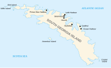
165:– an island at the north side of Husvik Harbor.
176:South Georgia Heritage Trust; Photos at Husvik
106:The freezer plant was dismantled and moved to
228:
8:
253:South Georgia and the South Sandwich Islands
587:
555:
528:
235:
221:
213:
45:. It was one of three such stations in
7:
25:
245:
354:Settlements / Whaling stations
121:As with Leith, Stromness, and
1:
79:and Husvik (NASA imagery).
793:
61:to South Georgia in 1925.
26:
345:Invasion of South Georgia
260:
140:is close to the station.
112:British Antarctic Survey
308:List of South Georgians
506:South Sandwich Islands
99:
91:
80:
49:, the other two being
31:of the same name, see
415:South Georgia islands
97:
86:
71:with (left to right)
67:
487:South Georgia Island
406:Corbeta Uruguay base
330:South Georgia Museum
313:Operation "Paraquet"
43:South Georgia Island
467:Pickersgill Islands
396:Prince Olav Harbour
195: /
123:Prince Olav Harbour
731:Thatcher Peninsula
462:Kupriyanov Islands
100:
92:
81:
764:
763:
618:
617:
586:
585:
560:Traversay Islands
554:
553:
533:Candlemas Islands
381:King Edward Point
293:Foreign relations
264:King Edward Point
199:54.18°S 36.7116°W
29:Norwegian village
16:(Redirected from
784:
691:Mount Cunningham
588:
556:
529:
255:
251:
249:
248:
237:
230:
223:
214:
210:
209:
207:
206:
205:
204:-54.18; -36.7116
200:
196:
193:
192:
191:
188:
33:Husvik, Tønsberg
21:
792:
791:
787:
786:
785:
783:
782:
781:
767:
766:
765:
760:
716:Salisbury Plain
666:Fortuna Glacier
661:Barff Peninsula
656:Allardyce Range
639:
630:Protector Shoal
614:
582:
550:
527:
501:
492:Welcome Islands
422:Annenkov Island
410:
349:
318:Public holidays
266:
256:
246:
244:
243:
241:
203:
201:
197:
194:
189:
186:
184:
182:
181:
172:
149:
36:
23:
22:
15:
12:
11:
5:
790:
788:
780:
779:
769:
768:
762:
761:
759:
758:
753:
751:Possession Bay
748:
746:Cumberland Bay
743:
738:
733:
728:
726:Southern Thule
723:
721:Salvesen Range
718:
713:
711:Peggotty Bluff
708:
703:
698:
693:
688:
683:
678:
676:Larsen Harbour
673:
668:
663:
658:
653:
651:Admiralty Peak
647:
645:
641:
640:
638:
637:
632:
626:
624:
620:
619:
616:
615:
613:
612:
607:
602:
600:Bellingshausen
596:
594:
592:Southern Thule
584:
583:
581:
580:
575:
570:
564:
562:
552:
551:
549:
548:
543:
537:
535:
526:
525:
520:
515:
509:
507:
503:
502:
500:
499:
497:Willis Islands
494:
489:
484:
479:
474:
469:
464:
459:
454:
449:
444:
439:
434:
429:
424:
418:
416:
412:
411:
409:
408:
403:
398:
393:
388:
383:
378:
373:
368:
363:
357:
355:
351:
350:
348:
347:
342:
337:
332:
327:
326:
325:
315:
310:
305:
300:
295:
290:
285:
280:
274:
272:
268:
267:
261:
258:
257:
242:
240:
239:
232:
225:
217:
179:
178:
171:
170:External links
168:
167:
166:
160:
155:
148:
145:
138:Admiralty Peak
24:
14:
13:
10:
9:
6:
4:
3:
2:
789:
778:
775:
774:
772:
757:
754:
752:
749:
747:
744:
742:
741:Stromness Bay
739:
737:
734:
732:
729:
727:
724:
722:
719:
717:
714:
712:
709:
707:
704:
702:
699:
697:
694:
692:
689:
687:
686:Mount Belinda
684:
682:
679:
677:
674:
672:
669:
667:
664:
662:
659:
657:
654:
652:
649:
648:
646:
642:
636:
633:
631:
628:
627:
625:
621:
611:
608:
606:
603:
601:
598:
597:
595:
593:
589:
579:
576:
574:
571:
569:
566:
565:
563:
561:
557:
547:
544:
542:
539:
538:
536:
534:
530:
524:
521:
519:
516:
514:
511:
510:
508:
504:
498:
495:
493:
490:
488:
485:
483:
480:
478:
477:Saddle Island
475:
473:
470:
468:
465:
463:
460:
458:
455:
453:
450:
448:
447:Cooper Island
445:
443:
440:
438:
435:
433:
430:
428:
425:
423:
420:
419:
417:
413:
407:
404:
402:
399:
397:
394:
392:
391:Ocean Harbour
389:
387:
386:Leith Harbour
384:
382:
379:
377:
374:
372:
369:
367:
364:
362:
359:
358:
356:
352:
346:
343:
341:
338:
336:
333:
331:
328:
324:
323:Toothfish Day
321:
320:
319:
316:
314:
311:
309:
306:
304:
301:
299:
296:
294:
291:
289:
286:
284:
281:
279:
276:
275:
273:
269:
265:
259:
254:
238:
233:
231:
226:
224:
219:
218:
215:
211:
208:
177:
174:
173:
169:
164:
161:
159:
156:
154:
153:Alert Channel
151:
150:
146:
144:
141:
139:
133:
130:
128:
124:
119:
117:
113:
109:
104:
96:
90:
89:Stromness Bay
87:Husvik is on
85:
78:
74:
73:Leith Harbour
70:
69:Stromness Bay
66:
62:
60:
56:
55:Leith Harbour
52:
48:
47:Stromness Bay
44:
40:
34:
30:
19:
18:Husvik Harbor
736:Bay of Isles
671:Gold Harbour
635:Kemp Caldera
472:Prion Island
452:Grass Island
442:Clerke Rocks
375:
283:Commissioner
278:Coat of arms
180:
163:Brain Island
142:
134:
131:
120:
105:
101:
38:
37:
756:Busen Point
701:Mount Roots
696:Mount Paget
681:Mount Baume
546:Vindication
437:Black Rocks
427:Bird Island
361:Bird Island
340:Sovereignty
202: /
578:Zavodovski
482:Shag Rocks
432:Black Rock
190:36°42′42″W
187:54°10′48″S
158:Alert Cove
706:Orca Peak
644:Landmarks
623:Seamounts
541:Candlemas
457:Grassholm
401:Stromness
366:Grytviken
303:Languages
262:Capital:
108:Grytviken
77:Stromness
51:Stromness
771:Category
523:Saunders
147:See also
127:asbestos
59:reindeer
27:For the
573:Visokoi
518:Montagu
513:Bristol
371:Godthul
298:History
271:General
568:Leskov
376:Husvik
250:
39:Husvik
610:Thule
605:Cook
288:Flag
116:BSES
53:and
335:.gs
773::
75:,
236:e
229:t
222:v
35:.
20:)
Text is available under the Creative Commons Attribution-ShareAlike License. Additional terms may apply.