429:
177:
144:
137:
170:
34:
542:
313:
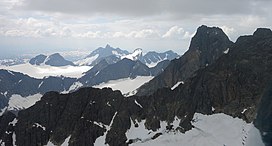
The range has some of the most alpine peaks in Norway, and has 23 peaks over 2,000 metres (6,600 ft) (counting peaks with larger prominence than 30 metres or 98 feet). Several of the peaks are only accessible through
583:
520:
576:
92:
224:
602:
627:
136:
569:
607:
217:
85:
442:
428:
337:
307:
169:
421:, referring to an active thing/person. The actual mountains are steep, and there are frequent rockslides and
367:
617:
361:
56:
39:
343:
486:
373:
612:
379:
622:
516:
553:
462:
327:
33:
287:
256:
60:
596:
403:
315:
541:
349:
355:
323:
303:
263:
414:
which means "hurry, move fast (with noise and roar)". The last element is the
239:
226:
107:
94:
422:
549:
407:
402:, the finite singular of the same word, is the names of two mountains in
295:
291:
206:
64:
425:
from the hillsides. The meaning of the name is then "the noisemakers".
319:
415:
299:
210:
75:
68:
513:
Scandinavian
Mountains and Peaks Over 2000 Metres in the Hurrungane
466:
427:
490:
322:
crossings. The starting point for hiking is the village of
548:
This article about a mountain, mountain range, or peak in
557:
302:. The area is southwest in the larger mountain range
255:
216:
202:
123:
84:
74:
52:
47:
21:
432:The east face of Hurrungane as seen down Uradalen.
352:(Gjertvasstind): 2,351 m or 7,713 ft
577:
8:
286:) is a mountain range in the municipalities
584:
570:
38:Hurrungane seen looking towards the west.
18:
454:
340:(Storen): 2,405 m or 7,890 ft
7:
538:
536:
556:. You can help Knowledge (XXG) by
333:The highest peaks in the area are
176:
143:
14:
326:along the national tourist road,
27:Hurrungene, Hurrungadn, Horungane
540:
410:. The first element is the verb
175:
168:
142:
135:
32:
463:"Hurrungane, Luster (Vestland)"
394:is the finite plural of a word
382:: 2,202 m or 7,224 ft
376:: 2,222 m or 7,290 ft
370:: 2,284 m or 7,493 ft
364:: 2,340 m or 7,680 ft
358:: 2,348 m or 7,703 ft
346:: 2,387 m or 7,831 ft
1:
80:2,405 m (7,890 ft)
42:is the highest peak visible.
443:List of mountains of Norway
644:
535:
603:Mountain ranges of Norway
308:Jotunheimen National Park
128:
31:
26:
156:Location of the mountain
16:Mountain range in Norway
628:Vestland mountain stubs
511:Baxter, James (2005).
433:
344:Store Styggedalstinden
338:Store Skagastølstinden
608:Landforms of Vestland
487:Store norske leksikon
431:
368:Midtre Skagastølstind
380:Store Austanbotntind
362:Vetle Skagastølstind
306:and is also part of
159:Show map of Vestland
108:61.46139°N 7.87139°E
57:Store Skagastølstind
40:Store Skagastølstind
236: /
189:Hurrungane (Norway)
104: /
434:
240:61.4495°N 7.8434°E
192:Show map of Norway
48:Highest point
565:
564:
522:978-0-9550497-0-5
269:
268:
218:Range coordinates
113:61.46139; 7.87139
635:
586:
579:
572:
544:
537:
527:
526:
508:
502:
501:
499:
498:
483:
477:
476:
474:
473:
465:(in Norwegian).
459:
374:Skagastølsnebbet
328:Sognefjellsvegen
259:
251:
250:
248:
247:
246:
241:
237:
234:
233:
232:
229:
193:
179:
178:
172:
160:
146:
145:
139:
119:
118:
116:
115:
114:
109:
105:
102:
101:
100:
97:
36:
19:
643:
642:
638:
637:
636:
634:
633:
632:
593:
592:
591:
590:
533:
531:
530:
523:
510:
509:
505:
496:
494:
485:
484:
480:
471:
469:
461:
460:
456:
451:
439:
389:
257:
245:61.4495; 7.8434
244:
242:
238:
235:
230:
227:
225:
223:
222:
198:
197:
196:
195:
194:
191:
190:
187:
186:
185:
184:
180:
163:
162:
161:
158:
157:
154:
153:
152:
151:
147:
112:
110:
106:
103:
98:
95:
93:
91:
90:
43:
17:
12:
11:
5:
641:
639:
631:
630:
625:
620:
618:Luster, Norway
615:
610:
605:
595:
594:
589:
588:
581:
574:
566:
563:
562:
545:
529:
528:
521:
503:
493:(in Norwegian)
478:
453:
452:
450:
447:
446:
445:
438:
435:
388:
385:
384:
383:
377:
371:
365:
359:
353:
347:
341:
274:(also written
267:
266:
261:
253:
252:
220:
214:
213:
204:
200:
199:
188:
182:
181:
174:
173:
167:
166:
165:
164:
155:
149:
148:
141:
140:
134:
133:
132:
131:
130:
129:
126:
125:
121:
120:
88:
82:
81:
78:
72:
71:
54:
50:
49:
45:
44:
37:
29:
28:
24:
23:
15:
13:
10:
9:
6:
4:
3:
2:
640:
629:
626:
624:
621:
619:
616:
614:
611:
609:
606:
604:
601:
600:
598:
587:
582:
580:
575:
573:
568:
567:
561:
559:
555:
551:
546:
543:
539:
534:
524:
518:
514:
507:
504:
492:
488:
482:
479:
468:
464:
458:
455:
448:
444:
441:
440:
436:
430:
426:
424:
420:
417:
413:
409:
405:
401:
397:
393:
386:
381:
378:
375:
372:
369:
366:
363:
360:
357:
354:
351:
348:
345:
342:
339:
336:
335:
334:
331:
329:
325:
321:
317:
311:
309:
305:
301:
297:
293:
289:
285:
281:
277:
273:
265:
262:
260:
254:
249:
221:
219:
215:
212:
208:
205:
201:
171:
138:
127:
122:
117:
89:
87:
83:
79:
77:
73:
70:
66:
62:
58:
55:
51:
46:
41:
35:
30:
25:
20:
558:expanding it
547:
532:
512:
506:
495:. Retrieved
491:"Hurrungane"
481:
470:. Retrieved
457:
418:
411:
399:
395:
391:
390:
350:Jervvasstind
332:
312:
283:
279:
275:
271:
270:
258:Parent range
613:Jotunheimen
356:Sentraltind
304:Jotunheimen
264:Jotunheimen
243: /
111: /
86:Coordinates
597:Categories
497:2010-09-10
472:2020-01-07
449:References
423:avalanches
392:Hurrungane
280:Hurrungadn
276:Hurrungene
272:Hurrungane
228:61°26′58″N
183:Hurrungane
150:Hurrungane
99:07°52′17″E
96:61°27′41″N
22:Hurrungane
400:Hurrungen
284:Horungane
231:7°50′36″E
124:Geography
76:Elevation
550:Vestland
437:See also
330:(RV55).
324:Turtagrø
316:climbing
298:county,
296:Vestland
207:Vestland
203:Location
396:hurrung
320:glacier
519:
416:suffix
300:Norway
288:Luster
211:Norway
69:Norway
61:Luster
59:,
623:Årdal
552:is a
467:yr.no
412:hurra
408:Skjåk
404:Rauma
292:Årdal
65:Årdal
554:stub
517:ISBN
419:-ung
406:and
387:Name
290:and
53:Peak
318:or
294:in
599::
515:.
489:.
398:.
310:.
282:,
278:,
209:,
67:,
585:e
578:t
571:v
560:.
525:.
500:.
475:.
63:/
Text is available under the Creative Commons Attribution-ShareAlike License. Additional terms may apply.