417:, Dalilia weakened to a minimal hurricane. The storm maintained this intensity until July 19, at which time the system slowed and turned northwest. The following day, the weakening tropical storm brushed the Hawaiian Islands to the south, eventually curving away from the island chain on July 21. Later that day, Dalilia further weakened to a tropical depression, with the Central Pacific Hurricane Center issuing their final advisory at that time. The remnants of the former hurricane continued to track northwest. On July 24, the system interacted with the remnants of Tropical Storm Erick and may have briefly re-attained tropical storm intensity; however, by July 28, the storm was rapidly tracking north through the
494:
1007:
150:
353:. Upon being designated a depression, it was still partially embedded within the ITCZ, inhibiting rapid development. In fact, the National Hurricane Center did not operationally begin advisories on the depression until almost 24 hours later. After the National Hurricane Center began issuing advisories, the depression quickly became more well-defined, as it began separating from the ITCZ on July 12. In addition, significant further intensification was expected, as
29:
1324:
279:
210:
289:
299:
464:
received up to 3 in (76 mm) of rain with localized areas reporting up to 8 in (200 mm). Hurricane
Dalilia contributed to a record rainfall total for the month of July in Honolulu with 2.33 in (59 mm) falling during the storm's passage. The heaviest rainfall was recorded
376:
predicted it to reach winds of 100 mph (155 km/h) by July 15. Six hours later, the
National Hurricane Center upgraded Dalilia to a hurricane, after winds were estimated at 75 mph (120 km/h), and satellite imagery suggested that the hurricane was continuing to organize. However,
397:
to the north and northeast of
Dalilia. Although the National Hurricane Center operationally held the intensity of Dalilia at minimal hurricane status for a while; post-analysis data show that Dalilia was slowly intensifying. By July 16, the storm developed a
481:
to shut down several roads. Many power lines were down, which produced minor wind damage. Despite causing power outages, there were no reports of injuries or major property damage. Overall, impact from
Tropical Storm Dalilia was less than anticipated.
196:
on July 28. The cyclone's effects were minimal. There was high surf, and some gusty winds. Damage was minor, and mainly limited to downed power lines. However, many areas throughout the island chain received more than 5 in (130 mm) of
188:. The storm accelerated, and headed directly towards the Hawaiian Islands. Hurricane Dalilia passed just south of the Hawaiian Islands as a tropical storm before dissipating July 21 as it interacted with a
986:
473:, upwards of 9 in (230 mm) of rain fell. The remnants of the storm continued to produce unseasonable rains in the Northwestern Hawaiian Islands through July 28. Heavy rains caused minor
180:. A tropical disturbance developed into a tropical depression on July 11 and into Hurricane Dalilia on July 13. Dalilia crossed 140°W shortly after reaching its maximum intensity and entered the
413:'s area of responsibility, the storm reached its peak intensity with winds of 90 mph (150 km/h) and a central pressure of 977 mbar (hPa; 28.85 inHg). After crossing
979:
917:
972:
860:
822:
365:. Tracking in a general west-northwest direction, the depression intensified into a tropical storm late on July 12, at which time it was given the name
192:. It then interacted with the remains of Tropical Storm Erick and reformed into a depression on July 24. A trough then accelerated the remnants towards the
452:
While tracking near the
Hawaiian Islands, Dalilia produced waves up to 20 ft (6.1 m) along south-facing coastlines. Along the coasts of
1353:
1348:
1327:
442:
430:
438:
410:
181:
770:
747:
724:
701:
652:
629:
606:
583:
560:
318:
678:
537:
1309:
1297:
1285:
1261:
1249:
1225:
1213:
1201:
1177:
1153:
1141:
1129:
1117:
1105:
1081:
1069:
1045:
1033:
1021:
996:
160:
460:, winds gusted up to 45 mph (75 km/h); the winds caused minor damage, mainly downed power lines. Most areas on
373:
198:
512:
342:
959:
223:
73:
1273:
499:
469:, with localized areas receiving rainfall in excess of 10 in (250 mm). Along the southeast slopes of
354:
77:
377:
post-storm analysis show this upgrade as several hours premature. While
Dalilia developed well-defined spiral
1237:
1165:
1006:
1057:
399:
334:
185:
964:
1189:
922:
507:
457:
403:
326:
302:
189:
402:, leading to further intensification. Although the storm tracked near cool waters, a well-developed
414:
292:
341:
intensity estimates. Continued development took place in the following days; on July 11, the
145:
394:
358:
437:. Officials urged residents to stock up on supplies and they closed beaches. Even though the
935:
902:
878:
838:
434:
418:
346:
338:
282:
193:
177:
173:
106:
28:
149:
478:
446:
350:
1342:
389:
values, upper-level winds appeared less favorable for further intensification, after
382:
330:
314:
102:
362:
213:
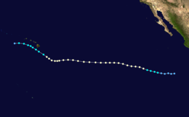
Map plotting the storm's track and intensity, according to the Saffir–Simpson scale
800:
209:
865:
390:
445:, this failed to occur; instead, the watch was discontinued on July 20 because
489:
386:
98:
357:(SST's) were greater than 78.8 °F (26 °C). Only a few hours later,
329:
suppressed the ITCZ. By July 9, the disturbance had entered the eastern
470:
927:
870:
830:
378:
960:
The
National Hurricane Center's Preliminary Report on Hurricane Dalilia
453:
931:
874:
834:
322:
138:
474:
466:
208:
372:
Dalilia rapidly intensified after becoming a tropical storm, and
325:. As the system became increasingly organized, the disturbance's
461:
449:
were now expecting the storm to pass south of the island chain.
968:
237:
Tropical storm (39–73 mph, 63–118 km/h)
232:
Tropical depression (≤38 mph, ≤62 km/h)
305:, remnant low, tropical disturbance, or monsoon depression
257:
Category 4 (130–156 mph, 209–251 km/h)
252:
Category 3 (111–129 mph, 178–208 km/h)
421:. The remnants of Dalilia dissipated shortly thereafter.
247:
Category 2 (96–110 mph, 154–177 km/h)
441:
remarked that that watch will likely be upgraded into a
429:
In preparation of the storm, a high surf advisory and a
242:
Category 1 (74–95 mph, 119–153 km/h)
321:(ITCZ) during early July 1989 off the west coast of
262:
Category 5 (≥157 mph, ≥252 km/h)
16:
Third hurricane of the 1989 Pacific hurricane season
134:
126:
118:
113:
92:
84:
61:
53:
45:
38:
33:
Hurricane
Dalilia at peak intensity on July 16
801:"The 1989 Central Pacific Tropical Cyclone Season"
803:. National Oceanic and Atmospheric Administration
1296:
1291:
799:Central Pacific Hurricane Center (May 4, 2007).
381:, it had remained a minimal hurricane, since no
1308:
1303:
508:Other tropical cyclones named Dalilia or Dalila
1284:
1279:
679:"Hurricane Dalilia Preliminary Report, Page 3"
385:had formed. Despite earlier forecasts for low
980:
538:"Hurricane Dalilia Preliminary Report Page 1"
8:
406:allowed it to maintain hurricane-intensity.
21:
1260:
1255:
987:
973:
965:
345:determined that the disturbance spawned a
148:
27:
20:
1104:
1099:
349:792 mi (1,275 km) southwest of
1080:
1075:
1068:
1063:
584:"Tropical Depression Six-E Discussion 2"
561:"Tropical Depression Six-E Discussion 1"
794:
792:
790:
788:
523:
1248:
1243:
1152:
1147:
672:
670:
531:
529:
527:
313:Hurricane Dalilia originated out of a
1176:
1171:
630:"Tropical Storm Dalilia Discussion 5"
607:"Tropical Storm Dalilia Discussion 3"
7:
1128:
1123:
1272:
1267:
1212:
1207:
1092:
1087:
1044:
1039:
1032:
1027:
1020:
1015:
393:imagery showed several upper-level
1236:
1231:
1224:
1219:
1200:
1195:
1164:
1159:
1116:
1111:
861:"Hurricane moves closer to Hawaii"
14:
1056:
1051:
771:"Hurricane Dalilia Discussion 19"
748:"Hurricane Dalilia Discussion 17"
409:Shortly before crossing into the
361:showed a significant increase in
1323:
1322:
1188:
1183:
1005:
725:"Hurricane Dalilia Discussion 9"
723:Harold Gerrish (July 14, 1989).
702:"Hurricane Dalilia Discussion 7"
653:"Hurricane Dalilia Discussion 6"
628:Harold Gerrish (July 13, 1989).
492:
439:Central Pacific Hurricane Center
411:Central Pacific Hurricane Center
297:
287:
277:
182:Central Pacific Hurricane Center
1140:
1135:
769:Gilbert Clark (July 16, 1989).
605:Jerry Jarrell (July 12, 1989).
582:Jerry Jarrell (July 12, 1989).
746:Max Mayfield (July 16, 1989).
319:Intertropical Convergence Zone
1:
1354:1989 Pacific hurricane season
1349:Category 1 Pacific hurricanes
997:1989 Pacific hurricane season
823:"Hawaii Braces for hurricane"
677:Jim Gross (August 30, 1989).
651:Robert Case (July 13, 1989).
559:Robert Case (July 12, 1989).
536:Jim Gross (August 30, 1989).
161:1989 Pacific hurricane season
773:. National Hurricane Center
750:. National Hurricane Center
727:. National Hurricane Center
704:. National Hurricane Center
700:Jim Gross (July 13, 1989).
681:. National Hurricane Center
655:. National Hurricane Center
632:. National Hurricane Center
609:. National Hurricane Center
586:. National Hurricane Center
563:. National Hurricane Center
540:. National Hurricane Center
88:90 mph (150 km/h)
1370:
176:during 1989 to affect the
1318:
1012:
1003:
995:Tropical cyclones of the
513:List of Hawaii hurricanes
343:National Hurricane Center
156:
144:
68:
26:
500:tropical cyclones portal
355:sea surface temperatures
425:Preparations and impact
374:several computer models
900:"Other News to note".
400:central dense overcast
335:convective development
310:
205:Meteorological history
186:area of responsibility
40:Meteorological history
923:The Victoria Advocate
465:on the north side of
303:Extratropical cyclone
212:
433:were issued for the
431:tropical storm watch
315:tropical disturbance
224:Saffir–Simpson scale
93:Lowest pressure
63:Category 1 hurricane
347:tropical depression
293:Subtropical cyclone
23:
395:low pressure areas
311:
85:Highest winds
70:1-minute sustained
1336:
1335:
827:The Press-Courier
479:transit officials
443:hurricane warning
359:satellite imagery
170:Hurricane Dalilia
167:
166:
22:Hurricane Dalilia
1361:
1326:
1325:
1306:
1294:
1282:
1270:
1258:
1246:
1234:
1222:
1210:
1198:
1186:
1174:
1162:
1150:
1138:
1126:
1114:
1102:
1090:
1078:
1066:
1054:
1042:
1030:
1018:
1009:
989:
982:
975:
966:
948:
947:
945:
943:
936:Associated Press
914:
908:
907:
906:. July 20, 1989.
903:Orlando Sentinel
897:
891:
890:
888:
886:
879:Associated Press
857:
851:
850:
848:
846:
839:Associated Press
819:
813:
812:
810:
808:
796:
783:
782:
780:
778:
766:
760:
759:
757:
755:
743:
737:
736:
734:
732:
720:
714:
713:
711:
709:
697:
691:
690:
688:
686:
674:
665:
664:
662:
660:
648:
642:
641:
639:
637:
625:
619:
618:
616:
614:
602:
596:
595:
593:
591:
579:
573:
572:
570:
568:
556:
550:
549:
547:
545:
533:
502:
497:
496:
495:
435:Hawaiian Islands
419:Aleutian Islands
379:convective bands
339:Dvorak Technique
317:embedded in the
301:
300:
291:
290:
283:Tropical cyclone
281:
280:
266:
261:
256:
251:
246:
241:
236:
231:
194:Aleutian Islands
178:Hawaiian Islands
174:tropical cyclone
152:
109:
64:
41:
31:
24:
1369:
1368:
1364:
1363:
1362:
1360:
1359:
1358:
1339:
1338:
1337:
1332:
1314:
1313:
1312:
1307:
1304:
1301:
1300:
1295:
1292:
1289:
1288:
1283:
1280:
1277:
1276:
1271:
1268:
1265:
1264:
1259:
1256:
1253:
1252:
1247:
1244:
1241:
1240:
1235:
1232:
1229:
1228:
1223:
1220:
1217:
1216:
1211:
1208:
1205:
1204:
1199:
1196:
1193:
1192:
1187:
1184:
1181:
1180:
1175:
1172:
1169:
1168:
1163:
1160:
1157:
1156:
1151:
1148:
1145:
1144:
1139:
1136:
1133:
1132:
1127:
1124:
1121:
1120:
1115:
1112:
1109:
1108:
1103:
1100:
1097:
1096:
1091:
1088:
1085:
1084:
1079:
1076:
1073:
1072:
1067:
1064:
1061:
1060:
1055:
1052:
1049:
1048:
1043:
1040:
1037:
1036:
1031:
1028:
1025:
1024:
1019:
1016:
1010:
999:
993:
956:
951:
941:
939:
938:. July 21, 1989
916:
915:
911:
899:
898:
894:
884:
882:
881:. July 19, 1989
859:
858:
854:
844:
842:
841:. July 19, 1989
821:
820:
816:
806:
804:
798:
797:
786:
776:
774:
768:
767:
763:
753:
751:
745:
744:
740:
730:
728:
722:
721:
717:
707:
705:
699:
698:
694:
684:
682:
676:
675:
668:
658:
656:
650:
649:
645:
635:
633:
627:
626:
622:
612:
610:
604:
603:
599:
589:
587:
581:
580:
576:
566:
564:
558:
557:
553:
543:
541:
535:
534:
525:
521:
498:
493:
491:
488:
427:
333:and sufficient
309:
308:
307:
306:
298:
295:
288:
285:
278:
275:
269:
268:
264:
263:
259:
258:
254:
253:
249:
248:
244:
243:
239:
238:
234:
233:
229:
227:
218:
214:
207:
157:
114:Overall effects
96:
62:
39:
34:
17:
12:
11:
5:
1367:
1365:
1357:
1356:
1351:
1341:
1340:
1334:
1333:
1331:
1330:
1319:
1316:
1315:
1302:
1298:Twenty Three-E
1290:
1278:
1266:
1254:
1242:
1230:
1218:
1206:
1194:
1182:
1170:
1158:
1146:
1134:
1122:
1110:
1098:
1086:
1074:
1062:
1050:
1038:
1026:
1014:
1013:
1011:
1004:
1001:
1000:
994:
992:
991:
984:
977:
969:
963:
962:
955:
954:External links
952:
950:
949:
909:
892:
852:
814:
784:
761:
738:
715:
692:
666:
643:
620:
597:
574:
551:
522:
520:
517:
516:
515:
510:
504:
503:
487:
484:
447:meteorologists
426:
423:
351:Cabo San Lucas
296:
286:
276:
271:
270:
228:
221:
220:
219:
216:
215:
206:
203:
165:
164:
154:
153:
142:
141:
136:
135:Areas affected
132:
131:
128:
124:
123:
120:
116:
115:
111:
110:
105:); 28.85
94:
90:
89:
86:
82:
81:
66:
65:
59:
58:
55:
51:
50:
47:
43:
42:
36:
35:
32:
15:
13:
10:
9:
6:
4:
3:
2:
1366:
1355:
1352:
1350:
1347:
1346:
1344:
1329:
1321:
1320:
1317:
1311:
1310:Twenty Four-E
1299:
1287:
1275:
1263:
1251:
1239:
1227:
1215:
1203:
1191:
1179:
1167:
1155:
1143:
1131:
1119:
1107:
1095:
1083:
1071:
1059:
1047:
1035:
1023:
1008:
1002:
998:
990:
985:
983:
978:
976:
971:
970:
967:
961:
958:
957:
953:
937:
933:
929:
925:
924:
919:
913:
910:
905:
904:
896:
893:
880:
876:
872:
868:
867:
862:
856:
853:
840:
836:
832:
828:
824:
818:
815:
802:
795:
793:
791:
789:
785:
772:
765:
762:
749:
742:
739:
726:
719:
716:
703:
696:
693:
680:
673:
671:
667:
654:
647:
644:
631:
624:
621:
608:
601:
598:
585:
578:
575:
562:
555:
552:
539:
532:
530:
528:
524:
518:
514:
511:
509:
506:
505:
501:
490:
485:
483:
480:
477:which forced
476:
472:
468:
463:
459:
455:
450:
448:
444:
440:
436:
432:
424:
422:
420:
416:
412:
407:
405:
401:
396:
392:
388:
384:
380:
375:
370:
368:
364:
360:
356:
352:
348:
344:
340:
336:
332:
331:Pacific Ocean
328:
324:
320:
316:
304:
294:
284:
274:
226:
225:
211:
204:
202:
200:
199:precipitation
195:
191:
187:
183:
179:
175:
172:was the only
171:
163:
162:
155:
151:
147:
143:
140:
137:
133:
129:
125:
122:None reported
121:
117:
112:
108:
104:
100:
95:
91:
87:
83:
79:
75:
71:
67:
60:
57:July 21, 1989
56:
52:
49:July 11, 1989
48:
44:
37:
30:
25:
19:
1286:Twenty Two-E
1093:
940:. Retrieved
921:
918:"For Hawaii"
912:
901:
895:
883:. Retrieved
864:
855:
843:. Retrieved
826:
817:
805:. Retrieved
777:September 3,
775:. Retrieved
764:
754:September 3,
752:. Retrieved
741:
731:February 27,
729:. Retrieved
718:
708:February 27,
706:. Retrieved
695:
685:February 27,
683:. Retrieved
659:February 27,
657:. Retrieved
646:
636:February 27,
634:. Retrieved
623:
613:February 23,
611:. Retrieved
600:
590:February 23,
588:. Retrieved
577:
565:. Retrieved
554:
542:. Retrieved
451:
428:
408:
371:
369:by the NHC.
366:
312:
272:
222:
169:
168:
159:
158:Part of the
69:
18:
942:October 23,
885:October 23,
866:Daily Union
845:October 23,
391:water vapor
1343:Categories
519:References
456:and South
387:wind shear
363:convection
337:to prompt
273:Storm type
119:Fatalities
54:Dissipated
1250:Priscilla
1154:Henriette
471:Mauna Loa
1328:Category
1262:Twenty-E
1178:Juliette
928:Honolulu
871:Honolulu
831:Honolulu
486:See also
475:flooding
267:Unknown
1274:Raymond
1130:Flossie
1106:Seven-E
1094:Dalilia
1046:Barbara
807:May 26,
567:May 31,
544:May 31,
404:outflow
367:Dalilia
327:outflow
217:Map key
146:IBTrACS
130:Minimal
1238:Octave
1214:Manuel
1202:Lorena
1166:Ismael
1082:Five-E
1070:Four-E
1034:Adolph
1022:Winona
932:Hawaii
875:Hawaii
835:Hawaii
323:Africa
265:
260:
255:
250:
245:
240:
235:
230:
190:trough
139:Hawaii
127:Damage
46:Formed
1226:Narda
1118:Erick
1058:Cosme
467:Kauai
415:140°W
74:SSHWS
1190:Kiko
944:2011
887:2011
847:2011
809:2009
779:2009
756:2009
733:2011
710:2011
687:2011
661:2011
638:2011
615:2011
592:2011
569:2009
546:2009
462:Oahu
458:Kona
454:Ka'u
107:inHg
99:mbar
97:977
1142:Gil
383:eye
184:'s
103:hPa
78:NWS
1345::
1305:TD
1293:TD
1281:TD
1257:TD
1245:TS
1221:TS
1209:TS
1173:TS
1149:TS
1125:TS
1113:TS
1101:TD
1077:TD
1065:TD
1029:TS
1017:TS
934:.
930:,
926:.
920:.
877:.
873:,
869:.
863:.
837:.
833:,
829:.
825:.
787:^
669:^
526:^
201:.
1269:4
1233:4
1197:1
1185:3
1161:3
1137:1
1089:1
1053:1
1041:1
988:e
981:t
974:v
946:.
889:.
849:.
811:.
781:.
758:.
735:.
712:.
689:.
663:.
640:.
617:.
594:.
571:.
548:.
101:(
80:)
76:/
72:(
Text is available under the Creative Commons Attribution-ShareAlike License. Additional terms may apply.