51:
20:
82:. Fishing boats from Hvalba had and still have the opportunity to choose between the east and the west coast when they want to go fishing in wooden Faroese boats. Now most of the men work on board the trawlers of Hvalba, which use the harbour on the east coast. In the old days, before the boats got engines, the fish harbour (Fiskieiði) on the west coast was very important for the village. There were many boats and boathouses, up to 23 boats.
59:
135:
The first road to
Fiskieiði (Hvalbiareiði) was made in 1890, but not all the way, only to the so-called "Skallaportrið". The work continued on the rest of the road from time to time, but it was not all the way to the Fiskieði until after the first car had arrived in Hvalba in 1931. The road made it
126:
In 1890 wood stocks were laid on the harbour of
Fiskieiði, so that it would be easier to drag the boats to and from the sea. These stocks were there until 1973, when they were taken away, because they were in bad shape. The stocks from one of the gorges were replaced, but the ones from the other
118:, who was in charge of the work on the stone harbour. The stone harbour is still in good condition. But rough seas have taken a part of the cliff away, so the men of Hvalba had to use concrete instead, where the cliff had been.
102:, whose father was from Hvalba, if he could help them. He came to Hvalba and made the work last. They used 40 barrels of cement and every boat gave 8 barrels of sand for the work without any charge.
144:
in 1969, also through a road tunnel. So cars or lorries in Hvalba in 1931 could only drive in the village, mainly to and from the coal mines and to and from the
Hvalbiareiði on the west coast.
231:
136:
much easier for the fishermen, because they no longer had to carry the fish all the way back to the village. Hvalba was not connected with the neighbouring village of
50:
182:
94:
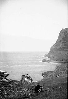
tried to use concrete to improve the facilities of the natural harbour, but they had problems with making it last. But in 1895 they asked
226:
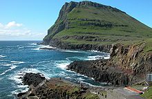
24:
111:
19:
110:
In 1924 the men from Hvalba wanted to improve the harbour even more, and a great work started. It was
221:
95:
174:
137:
215:
79:
141:
75:
71:
35:
197:
184:
58:
74:. Hvalba is located on an isthmus in the northern part of the island of
140:
until 1963 through a road tunnel, and with the other neighbour village
115:
91:
67:
39:
99:
57:
49:
18:
169:
106:
Jens Marius
Poulsen from Skopun and the stone harbour in 1924
34:
is also called
Fiskieiði, it is located on the west coast of
163:
16:Harbor on the west coast of Suðuroy, Faroe Islands
66:Hvalbiareiði has been an important harbour for
8:
122:Wooden Stocks on the harbour from 1890–1973
175:Photos on Flickr tagged with Hvalbiareiði
232:Tourist attractions in the Faroe Islands
86:Niels L. Arge stood for the work in 1895
54:The harbour of Fiskieiði/Hvalbiareiði.
7:
14:
23:Hvalbiareiði and the mountain
1:
166:, The Municipality of Hvalba.
90:In the 19th century men from
153:Article from Myndablaði Nú.
248:
127:gorge were not replaced.
62:Hvalbiareiði around 1899.
63:
55:
38:, west of the village
28:
61:
53:
22:
194: /
112:Jens Marius Poulsen
64:
56:
29:
227:Cliffs of Suðuroy
131:Road to Fiskieiði
239:
209:
208:
206:
205:
204:
199:
198:61.591°N 6.964°W
195:
192:
191:
190:
187:
247:
246:
242:
241:
240:
238:
237:
236:
212:
211:
202:
200:
196:
193:
188:
185:
183:
181:
180:
170:Visitsuduroy.fo
160:
150:
133:
124:
108:
88:
48:
17:
12:
11:
5:
245:
243:
235:
234:
229:
224:
214:
213:
203:61.591; -6.964
178:
177:
172:
167:
159:
158:External links
156:
155:
154:
149:
146:
132:
129:
123:
120:
107:
104:
87:
84:
47:
44:
15:
13:
10:
9:
6:
4:
3:
2:
244:
233:
230:
228:
225:
223:
220:
219:
217:
210:
207:
176:
173:
171:
168:
165:
162:
161:
157:
152:
151:
147:
145:
143:
139:
130:
128:
121:
119:
117:
113:
105:
103:
101:
97:
96:Niels L. Arge
93:
85:
83:
81:
80:Faroe Islands
77:
73:
69:
60:
52:
45:
43:
41:
37:
33:
26:
21:
179:
138:Trongisvágur
134:
125:
109:
89:
65:
32:Hvalbiareiði
31:
30:
201: /
216:Categories
186:61°35′28″N
148:References
25:Grímsfjall
189:6°57′50″W
164:Hvalba.fo
222:Suðuroy
142:Sandvík
76:Suðuroy
72:Suðuroy
46:History
36:Suðuroy
116:Skopun
92:Hvalba
68:Hvalba
40:Hvalba
114:from
100:Argir
98:from
70:in
218::
78:,
42:.
27:.
Text is available under the Creative Commons Attribution-ShareAlike License. Additional terms may apply.