28:
441:
134:
189:
and hence available for public access on foot. A couple of public footpaths traverse the hill north–south whilst numerous tracks run along its length. The larger part of the hill is within the national park, the boundary of which runs along the
1011:
191:
986:
996:
121:
981:
276:
966:
407:
27:
951:
186:
328:
946:
911:
302:
678:
429:
266:
England and Wales sheet 294 Solid & Drift
Geology. 1:50,000 scale geological map (Keyworth, Nottingham: British Geological Survey)
354:
235:
which is 9.3 metres (31 ft) in diameter. Several Roman coins have been found at
Hadborough at the western end of Haddon Hill.
1001:
446:
64:
115:
478:
57:
380:
1006:
976:
971:
718:
1087:
991:
893:
238:
During World War II a military camp was built on the hill with several buildings to accommodate soldiers from the
1066:
956:
916:
422:
1061:
1016:
936:
780:
178:
33:
723:
643:
608:
568:
203:
961:
941:
926:
921:
710:
221:
623:
239:
655:
415:
243:
931:
730:
628:
488:
181:
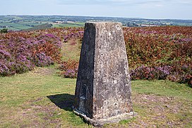
at 1,164 feet (355 m) above sea level. Much of the upper part of the hill is mapped as
1092:
1056:
1021:
888:
880:
805:
649:
603:
588:
538:
463:
182:
139:
1051:
875:
865:
840:
790:
775:
765:
618:
528:
512:
483:
199:
158:
209:
Along with its eastern neighbour, Heydon Hill, Haddon Hill is largely formed from the
1081:
1026:
845:
835:
825:
795:
735:
1046:
1041:
870:
800:
785:
665:
210:
170:
1031:
850:
820:
740:
705:
700:
695:
563:
533:
860:
855:
830:
810:
760:
755:
745:
518:
225:
177:
The highest point of the ridge at OS grid reference SS 962286 is crowned by a
133:
129:
224:, surrounded by a bank and ditch, on the hill was previously thought to be a
202:. Vehicular access is available off this road. The hill affords views across
79:
66:
770:
750:
660:
573:
553:
548:
174:
815:
613:
593:
583:
578:
543:
506:
452:
440:
214:
150:
104:
194:
which runs diagonally across the eastern end of the ridge en route from
638:
633:
598:
228:
195:
154:
108:
1036:
670:
523:
166:
162:
47:
277:"MSO12671 - Post-medieval stone or ballast quarrying at Haddon Hill"
558:
232:
217:
age sedimentary rocks. The stone has been quarried in the past.
411:
231:
although this is no longer the case. There is a Bronze Age
206:
which occupies the Haddeo valley immediately to its north.
329:"MSO8124 - Bronze Age Burial Cairn, Haddon Hill, Skilgate"
303:"MSO8112 - Tree-ring enclosure, Haddon Hill, Skilgate"
904:
688:
497:
471:
114:
100:
95:
56:
46:
41:
20:
355:"MSO8837 - Possible Roman activity at Hadborough"
157:, close to Hartford within the civil parish of
149:is a prominent east–west aligned ridge in west
423:
8:
169:massif itself by the valleys of the rivers
430:
416:
408:
17:
161:. It lies on the south-eastern fringe of
255:
187:Countryside and Rights of Way Act 2000
7:
381:"MSO8389 - Haddon Camp, Haddon Hill"
679:List of civil parishes in Somerset
385:Exmoor Historic Environment Record
359:Exmoor Historic Environment Record
333:Exmoor Historic Environment Record
307:Exmoor Historic Environment Record
281:Exmoor Historic Environment Record
14:
439:
132:
26:
997:Population of major settlements
262:British Geological Survey 1975
1:
165:though is separated from the
987:Parliamentary constituencies
479:Bath and North East Somerset
972:Lord Lieutenant of Somerset
1109:
952:Grade II* listed buildings
242:during the buildup to the
52:1,164 ft (355 m)
460:
36:on the top of Haddon Hill
25:
1067:West Somerset Coast Path
982:National nature reserves
957:High Sheriff of Somerset
947:Grade I listed buildings
211:Pickwell Down Sandstones
387:. Exmoor National Park
361:. Exmoor National Park
335:. Exmoor National Park
309:. Exmoor National Park
283:. Exmoor National Park
213:, a thick sequence of
1062:South West Coast Path
1017:Transport in Somerset
967:Local nature reserves
937:Geography of Somerset
204:Wimbleball Reservoir
163:Exmoor National Park
1002:Scheduled monuments
962:History of Somerset
942:Geology of Somerset
927:Economy of Somerset
922:Culture of Somerset
500:(cities in italics)
472:Unitary authorities
76: /
1020:Geographic areas:
240:United States Army
42:Highest point
1088:Hills of Somerset
1075:
1074:
656:Weston-super-Mare
498:Major settlements
447:Ceremonial county
244:Normandy landings
128:
127:
1100:
731:Badgworthy Water
489:Somerset Council
455:
449:
444:
443:
432:
425:
418:
409:
397:
396:
394:
392:
377:
371:
370:
368:
366:
351:
345:
344:
342:
340:
325:
319:
318:
316:
314:
299:
293:
292:
290:
288:
273:
267:
260:
142:
137:
136:
124:
91:
90:
88:
87:
86:
81:
80:51.050°N 3.483°W
77:
74:
73:
72:
69:
30:
18:
1108:
1107:
1103:
1102:
1101:
1099:
1098:
1097:
1078:
1077:
1076:
1071:
1057:Somerset Levels
1022:Blackdown Hills
1019:
900:
719:Bristol Channel
684:
673:
604:North Petherton
589:Midsomer Norton
499:
493:
467:
464:Somerset Portal
456:
451:
445:
438:
436:
406:
401:
400:
390:
388:
379:
378:
374:
364:
362:
353:
352:
348:
338:
336:
327:
326:
322:
312:
310:
301:
300:
296:
286:
284:
275:
274:
270:
261:
257:
252:
140:Somerset portal
138:
131:
120:
84:
82:
78:
75:
70:
67:
65:
63:
62:
37:
12:
11:
5:
1106:
1104:
1096:
1095:
1090:
1080:
1079:
1073:
1072:
1070:
1069:
1064:
1059:
1054:
1052:Quantock Hills
1049:
1044:
1039:
1034:
1029:
1024:
1014:
1009:
1004:
999:
994:
989:
984:
979:
974:
969:
964:
959:
954:
949:
944:
939:
934:
929:
924:
919:
917:County Council
914:
912:Country houses
908:
906:
902:
901:
899:
898:
897:
896:
894:South Somerset
891:
883:
878:
873:
868:
863:
858:
853:
848:
843:
841:Severn Estuary
838:
833:
828:
823:
818:
813:
808:
803:
798:
793:
791:Hoar Oak Water
788:
783:
778:
773:
768:
763:
758:
753:
748:
743:
738:
733:
728:
727:
726:
721:
713:
708:
703:
698:
692:
690:
686:
685:
683:
682:
668:
663:
658:
653:
646:
641:
636:
631:
626:
621:
619:Shepton Mallet
616:
611:
606:
601:
596:
591:
586:
581:
576:
571:
566:
561:
556:
551:
546:
541:
536:
531:
529:Burnham-on-Sea
526:
521:
516:
509:
503:
501:
495:
494:
492:
491:
486:
484:North Somerset
481:
475:
473:
469:
468:
461:
458:
457:
437:
435:
434:
427:
420:
412:
405:
404:External links
402:
399:
398:
372:
346:
320:
294:
268:
254:
253:
251:
248:
159:Brompton Regis
144:
143:
126:
125:
118:
112:
111:
102:
98:
97:
93:
92:
85:51.050; -3.483
60:
54:
53:
50:
44:
43:
39:
38:
31:
23:
22:
13:
10:
9:
6:
4:
3:
2:
1105:
1094:
1091:
1089:
1086:
1085:
1083:
1068:
1065:
1063:
1060:
1058:
1055:
1053:
1050:
1048:
1045:
1043:
1040:
1038:
1035:
1033:
1030:
1028:
1027:Brendon Hills
1025:
1023:
1018:
1015:
1013:
1010:
1008:
1005:
1003:
1000:
998:
995:
993:
990:
988:
985:
983:
980:
978:
975:
973:
970:
968:
965:
963:
960:
958:
955:
953:
950:
948:
945:
943:
940:
938:
935:
933:
930:
928:
925:
923:
920:
918:
915:
913:
910:
909:
907:
903:
895:
892:
890:
887:
886:
884:
882:
879:
877:
874:
872:
869:
867:
864:
862:
859:
857:
854:
852:
849:
847:
844:
842:
839:
837:
834:
832:
829:
827:
826:Midford Brook
824:
822:
819:
817:
814:
812:
809:
807:
804:
802:
799:
797:
794:
792:
789:
787:
784:
782:
779:
777:
774:
772:
769:
767:
764:
762:
759:
757:
754:
752:
749:
747:
744:
742:
739:
737:
734:
732:
729:
725:
722:
720:
717:
716:
714:
712:
709:
707:
704:
702:
699:
697:
694:
693:
691:
687:
681:
680:
676:
672:
669:
667:
664:
662:
659:
657:
654:
652:
651:
647:
645:
642:
640:
637:
635:
632:
630:
627:
625:
622:
620:
617:
615:
612:
610:
607:
605:
602:
600:
597:
595:
592:
590:
587:
585:
582:
580:
577:
575:
572:
570:
567:
565:
562:
560:
557:
555:
552:
550:
547:
545:
542:
540:
537:
535:
532:
530:
527:
525:
522:
520:
517:
515:
514:
510:
508:
505:
504:
502:
496:
490:
487:
485:
482:
480:
477:
476:
474:
470:
466:
465:
459:
454:
448:
442:
433:
428:
426:
421:
419:
414:
413:
410:
403:
386:
382:
376:
373:
360:
356:
350:
347:
334:
330:
324:
321:
308:
304:
298:
295:
282:
278:
272:
269:
265:
259:
256:
249:
247:
245:
241:
236:
234:
230:
227:
223:
218:
216:
212:
207:
205:
201:
197:
193:
188:
184:
180:
176:
172:
168:
164:
160:
156:
152:
148:
141:
135:
130:
123:
119:
117:
113:
110:
106:
103:
99:
94:
89:
61:
59:
55:
51:
49:
45:
40:
35:
29:
24:
19:
16:
1047:Polden Hills
1042:Mendip Hills
871:Wellow Brook
677:
674:
666:Wiveliscombe
648:
511:
462:
389:. Retrieved
384:
375:
363:. Retrieved
358:
349:
337:. Retrieved
332:
323:
311:. Retrieved
306:
297:
285:. Retrieved
280:
271:
263:
258:
237:
219:
208:
146:
145:
15:
1032:Chew Valley
889:Congresbury
885:Yeo rivers
715:Axe rivers
564:Glastonbury
534:Castle Cary
183:open access
147:Haddon Hill
83: /
58:Coordinates
21:Haddon Hill
1082:Categories
831:Oare Water
644:Wellington
609:Portishead
569:Highbridge
519:Bridgwater
391:9 December
365:9 December
339:9 December
313:9 December
287:9 December
250:References
226:Bronze Age
192:B3190 road
185:under the
179:trig point
34:trig point
881:Whitelake
806:Huntspill
751:Cam Brook
675:See also:
661:Wincanton
574:Ilminster
554:Dulverton
549:Crewkerne
264:Dulverton
246:in 1944.
222:tree ring
96:Geography
48:Elevation
876:West Lyn
866:Washford
816:Land Yeo
776:Fivehead
766:East Lyn
724:Lyme Bay
624:Somerton
614:Radstock
594:Minehead
584:Langport
579:Keynsham
544:Clevedon
507:Axbridge
453:Somerset
215:Devonian
151:Somerset
122:SS962286
105:Somerset
101:Location
1007:Schools
977:Museums
846:Sheppey
796:Holford
736:Banwell
639:Watchet
634:Taunton
599:Nailsea
229:tumulus
200:Bampton
196:Watchet
155:England
116:OS grid
109:England
68:51°03′N
1093:Exmoor
1037:Exmoor
992:Places
905:Topics
836:Parret
801:Horner
786:Haddeo
689:Rivers
671:Yeovil
629:Street
524:Bruton
171:Haddeo
167:Exmoor
71:3°29′W
1012:SSSIs
851:Somer
821:Mells
781:Frome
741:Barle
706:Avill
701:Aller
696:Alham
650:Wells
559:Frome
539:Chard
233:cairn
932:Flag
861:Tone
856:Sowy
811:Isle
761:Chew
756:Cary
746:Brue
711:Avon
513:Bath
393:2014
367:2014
341:2014
315:2014
289:2014
173:and
32:The
771:Exe
450:of
198:to
175:Exe
1084::
383:.
357:.
331:.
305:.
279:.
220:A
153:,
107:,
431:e
424:t
417:v
395:.
369:.
343:.
317:.
291:.
Text is available under the Creative Commons Attribution-ShareAlike License. Additional terms may apply.