119:
112:
208:
285:
36:
292:
Bedouin goatherds have a long history of climbing in the Hajhir. A 2014 study of
Soqotri oral storytelling traditions revealed that a number of popular myths recount ascents throughout the range by local goatherds. According to the anthropologist Christopher Elliott, many accounts demonstrate a
223:. The highest point of the range is the peak of Mashanig which lies at approximately 1,500 m (4,900 ft) above sea level. Other peaks of local prominence include Girhimitin, Hazrat Muqadriyoun and Herem Hajhir.
219:
spires of the Hajhir massif are located in the hinterland of
Socotra and are most easily accessed via the valley approaches north of the coastal town of
40:
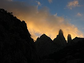
The twin peaks of
Mashanig. The fallen pillar bridging the peaks is called "Mishifo". The left-hand tower is the highest point of the range.
111:
68:
444:
302:
358:
61:
241:), sometimes transliterated as "Hagghier" or "Hagher" in English, likely derives from the Arabic "ḥijr" (
390:
307:
293:
strong oral chain of transmission that links mythical characters with actual pre-modern ascents.
207:
402:
344:
312:
439:
232:
338:
415:
248:
20:
247:, meaning "stone"). Other possible origins of the range's name include the word "hajar" (
188:
155:
433:
172:
317:
284:
365:
83:
70:
264:, meaning "the split one"), likely derives from the Arabic verb "inshaq" (
216:
192:
144:
220:
51:
35:
283:
206:
196:
148:
270:, meaning "to split"), from which one gets the word "munshuq" (
16:
Mountain range situated on the island of
Socotra, Yemen
171:
166:
154:
140:
99:
60:
50:
45:
28:
8:
271:
265:
259:
242:
236:
25:
199:. It is the highest point of the island.
118:
340:Hajhir Mountains, Socotra Island, Yemen
330:
411:
400:
391:Shop "From Rock Upon Rock, A Mountain"
177:Unknown, possibly a Soqotri goatherder
7:
19:For the mountain range in Oman, see
272:
266:
260:
252:
243:
237:
14:
117:
110:
34:
303:Socotra Island xeric shrublands
397:. Height of Land Publications.
258:The name "Mashanig" (Soqotri:
1:
56:1,503 m (4,931 ft)
461:
191:situated on the island of
18:
104:
33:
445:Mountain ranges of Yemen
276:, meaning "splittist").
84:12.582376°N 54.039919°E
389:Elliott, Christopher.
289:
255:, meaning "to flee").
212:
287:
210:
308:Hadhramaut Mountains
89:12.582376; 54.039919
231:The name "Hajhir" (
80: /
290:
213:
46:Highest point
395:Alpinist Magazine
345:Earth Observatory
313:Sarawat Mountains
181:
180:
452:
420:
419:
413:
408:
406:
398:
386:
380:
379:
377:
376:
370:
364:. Archived from
363:
355:
349:
348:
335:
280:Climbing history
275:
274:
269:
268:
263:
262:
254:
246:
245:
240:
239:
211:Hajhir Mountains
162:Hajhir Mountains
158:
125:Hajhir Mountains
121:
120:
114:
95:
94:
92:
91:
90:
85:
81:
78:
77:
76:
73:
38:
29:Hajhir Mountains
26:
460:
459:
455:
454:
453:
451:
450:
449:
430:
429:
428:
423:
409:
399:
388:
387:
383:
374:
372:
368:
361:
357:
356:
352:
337:
336:
332:
328:
318:Haraz Mountains
299:
282:
229:
205:
156:
136:
135:
134:
133:
132:
129:
128:
127:
126:
122:
88:
86:
82:
79:
74:
71:
69:
67:
66:
41:
24:
21:Hajar Mountains
17:
12:
11:
5:
458:
456:
448:
447:
442:
432:
431:
427:
426:External links
424:
422:
421:
381:
350:
329:
327:
324:
323:
322:
321:
320:
310:
305:
298:
295:
281:
278:
228:
225:
204:
201:
189:mountain range
179:
178:
175:
169:
168:
164:
163:
160:
152:
151:
142:
138:
137:
130:
124:
123:
116:
115:
109:
108:
107:
106:
105:
102:
101:
97:
96:
64:
58:
57:
54:
48:
47:
43:
42:
39:
31:
30:
15:
13:
10:
9:
6:
4:
3:
2:
457:
446:
443:
441:
438:
437:
435:
425:
417:
404:
396:
392:
385:
382:
371:on 2017-04-29
367:
360:
354:
351:
346:
342:
341:
334:
331:
325:
319:
316:
315:
314:
311:
309:
306:
304:
301:
300:
296:
294:
286:
279:
277:
256:
250:
234:
226:
224:
222:
218:
209:
202:
200:
198:
194:
190:
186:
185:Hajhir massif
176:
174:
170:
165:
161:
159:
153:
150:
146:
143:
139:
113:
103:
98:
93:
65:
63:
59:
55:
53:
49:
44:
37:
32:
27:
22:
394:
384:
373:. Retrieved
366:the original
353:
347:, 2003-01-29
339:
333:
291:
257:
230:
214:
184:
182:
173:First ascent
157:Parent range
288:Mount Skand
87: /
62:Coordinates
434:Categories
412:|url=
375:2017-04-28
326:References
75:54°02′24″E
72:12°34′57″N
227:Etymology
203:Geography
100:Geography
52:Elevation
403:cite web
297:See also
167:Climbing
141:Location
440:Socotra
414:value (
359:"Aemnp"
273:مُنْشُق
267:إِنْشَق
261:مَشَنِغ
238:هَجْهِر
233:Soqotri
217:granite
193:Socotra
145:Socotra
131:Socotra
410:Check
249:Arabic
221:Hadibo
369:(PDF)
362:(PDF)
244:حِجْر
197:Yemen
187:is a
149:Yemen
416:help
215:The
183:The
253:هجر
436::
407::
405:}}
401:{{
393:.
343:,
251::
235::
195:,
147:,
418:)
378:.
23:.
Text is available under the Creative Commons Attribution-ShareAlike License. Additional terms may apply.