20:
49:
The range stretches east to west for a distance of approximately 40 kilometres (25 mi); it is surrounded by the Burt Plain. The highest point of the Hann Range is Mount Evatt with an elevation of 802 metres (2,631 ft). The
355:
316:
57:
The range is situated in the Ngalia Basin at the south and eastern end. The area is composed of a well defined ridge of silicified brown
62:
270:
43:
248:
96:
35:
296:
191:
226:
135:
131:
81:
166:
112:
39:
219:
292:
85:
73:
that overlooks Alice
Springs. The metamorphic basement is composed of Mount Bleechmore
51:
31:
349:
143:
100:
139:
331:
318:
108:
104:
74:
70:
66:
58:
19:
61:
overlaying the basement rock. The ridge is made up of outcropping
18:
220:"Bureau of Mineral Resources - Geology and Geophysics Records"
123:
means "the top of the shoulders across the neck" and
172:. Alice Springs Field Naturalists Club. November 2009
42:approximately 120 kilometres (75 mi) north of
167:"Alice Springs Field Naturalists Club Newsletter"
138:in 1870, after the explorers and pastoralists
107:peoples. The area is at the junction of many
8:
54:bisects the range not far from Mount Evatt.
293:"Place Names Register Extract - Hann Range"
130:The Range is thought to have been named by
356:Mountain ranges of the Northern Territory
214:
212:
155:
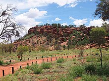
99:is located in the Range; the gap is a
161:
159:
7:
111:, and the name of the site in the
14:
271:"Native Gap Conservation Reserve"
197:. Crosland nickel. 8 January 2014
134:while surveying a route for the
97:Native Gap Conservation Reserve
65:quartzite of a similar age and
36:Northern Territory of Australia
192:"Aileron Project Final Report"
1:
297:Northern Territory Government
273:. Explore Australia's Outback
23:Native Gap in the Hann Range
16:Mountain range in Australia
372:
227:Commonwealth of Australia
136:Overland Telegraph Line
88:, who know the area as
332:22.79611°S 133.41333°E
24:
22:
337:-22.79611; 133.41333
103:to the Arrernte and
84:of the area are the
328: /
82:traditional owners
25:
113:Arrernte language
69:to the Heavitree
40:central Australia
363:
343:
342:
340:
339:
338:
333:
329:
326:
325:
324:
321:
308:
307:
305:
303:
289:
283:
282:
280:
278:
267:
261:
260:
258:
256:
245:
239:
238:
236:
234:
224:
216:
207:
206:
204:
202:
196:
188:
182:
181:
179:
177:
171:
163:
117:Arurlte Artwatye
109:creation stories
371:
370:
366:
365:
364:
362:
361:
360:
346:
345:
336:
334:
330:
327:
322:
319:
317:
315:
314:
312:
311:
301:
299:
291:
290:
286:
276:
274:
269:
268:
264:
254:
252:
247:
246:
242:
232:
230:
222:
218:
217:
210:
200:
198:
194:
190:
189:
185:
175:
173:
169:
165:
164:
157:
152:
86:Arrernte people
63:Vaughan Springs
17:
12:
11:
5:
369:
367:
359:
358:
348:
347:
310:
309:
284:
262:
240:
208:
183:
154:
153:
151:
148:
90:Arwerlt Atwaty
52:Stuart Highway
32:mountain range
15:
13:
10:
9:
6:
4:
3:
2:
368:
357:
354:
353:
351:
344:
341:
298:
294:
288:
285:
272:
266:
263:
251:. Central Art
250:
244:
241:
228:
221:
215:
213:
209:
193:
187:
184:
168:
162:
160:
156:
149:
147:
145:
141:
137:
133:
128:
127:means "gap".
126:
122:
118:
114:
110:
106:
102:
98:
93:
91:
87:
83:
78:
76:
72:
68:
64:
60:
55:
53:
47:
45:
44:Alice Springs
41:
37:
33:
29:
21:
313:
300:. Retrieved
287:
275:. Retrieved
265:
253:. Retrieved
249:"Anmatyerre"
243:
231:. Retrieved
199:. Retrieved
186:
174:. Retrieved
144:William Hann
129:
124:
120:
116:
94:
89:
79:
56:
48:
27:
26:
335: /
323:133°24′48″E
101:sacred site
38:located in
320:22°47′46″S
150:References
28:Hann Range
132:John Ross
105:Anmatyerr
75:granulite
71:quartzite
67:lithology
59:sandstone
350:Category
302:19 April
277:21 April
255:19 April
233:19 April
201:19 April
176:19 April
125:Artwatye
119:, where
121:Arurlte
34:in the
229:. 1965
223:(PDF)
195:(PDF)
170:(PDF)
140:Frank
30:is a
304:2015
279:2015
257:2015
235:2015
203:2015
178:2015
142:and
95:The
80:The
115:is
352::
295:.
225:.
211:^
158:^
146:.
92:.
77:.
46:.
306:.
281:.
259:.
237:.
205:.
180:.
Text is available under the Creative Commons Attribution-ShareAlike License. Additional terms may apply.