238:
another cataclysmic eruption. The southern portion of the caldera then collapsed, this time in a down-to-the-south trapdoor fashion. This formed a ‘double-trap door caldera’, a unique geologic structure. The second portion of the
Hannegan collapse was filled with the ignimbrite of Ruth Mountain, exposed from the northeast flank of Ruth Mountain to the southeast flank of Icy Peak to the south. The Ruth Mountain ignimbrite contains many clasts of volcanic rock that predates caldera collapse. This unit must have covered the northern portion of the caldera as well, but was stripped away in that section by erosion. No rock suitable for dating has been found in this unit.
185:. Over 10s or 100s of thousands of years, this upward deformation eventually resulted in a semicircular fracture, or ring fault to form in the brittle crust. This fault encircled the northern margin of the uplifted area and reaching down to the magma chamber, causing sudden release of confining pressure on the magma. Consequently the magma erupted huge volumes of magma as towering columns of volcanic ash and pumice, as well as pyroclastic flows. As the magma emptied, the surface collapsed in a trapdoor fashion down to the north, with the hinge on the south. Though no longer preserved due to millions of years of intense erosion, searing
28:
259:. Mineral analyses from these plutons indicate they cooled at least 1 km below the surface. Yet they are both exposed today due to erosion. They outcrop at the summit of Icy Peak (2156 m) and to within a few hundred feet of the summit of Ruth Mountain (2169 m), the highest point within the caldera. This indicates profound erosion of at least 1 km of intracaldera volcanic rocks in the 3.36 million years since intrusion of these plutons, including any volcanic deposits that may have been associated with the plutons.
20:
268:
190:
large landslides and left lenses of wall rock breccias and megabreccia interbedded in the tuff filling the collapsing caldera. This tuff, erupted in a single eruption, was lithified and is preserved as the ignimbrite of
Hannegan Peak; it is at least 900 meters thick with no base is exposed. It is confined within the northern half of the caldera’s structural margin. A relatively precise Ar/Ar
204:
157:
62:
126:. The caldera is traversed by portions of the Hannegan Pass, Hannegan Peak, Chillwack River, Copper Ridge, and Boundary trails, but most of it is in untracked and rugged mountainous terrain. It is among the best exposed and youngest trap door calderas in the world, and is believed to be the only described double trapdoor caldera on Earth.
229:
301:
calderas are small and erupted relatively small volumes of ash and ignimbrite. Hannegan caldera is only 8 x 3.5 km in outline, with a calculated eruption volume of 55-60 cubic km of magma. Only three calderas have formed in the
Cascades since the collapse at Hannegan, and each erupted about the same
280:
rock are scattered within the caldera, the remnants of lava flows. One sequence of three lava flows exposed on the ridge crest between Ruth
Mountain and Chilliwack Pass has a preserved thickness of 240 meters and is dated to 2.96 +/- 0.30 million years old. It is the youngest dated rock unit within
237:
A large volume of unerupted magma remained within the crust, and may have been augmented by subsequent intrusions. After only a brief interval, continued deformation caused the northern ring fault to propagate southward to form an oblong oval above the remaining magma, which again erupted in
189:
must have swept for 10s of kilometers down river valleys beyond the margins of the caldera, incinerating everything in their path. As the surface subsidized a kilometer or more during eruption, volcanic ash filled the resulting horseshoe-shaped caldera. Rock outside the ring fault slid inward as
250:
on Icy Peak and the eastern wall of
Nooksack Cirque. The older of these granitic masses is dated to 3.42 million years old, and therefore confines the rock filing the second episode of caldera collapse to the geologically brief 300,000 thousand year interval between the Hannegan
172:
rose high into the crust. This intrusion most likely caused the surface to dome upwards. Fractures caused by this deformation may have provided conduits for some magma to reach the surface and erupt into relatively small volcanic structures such as felsic and intermediate
143:
and alpine glaciations. No volcanic structures or rocks predating caldera collapse survived multiple glaciations and collapse of the caldera. However, the presence of volcanic rock fragments within the intracaldera tuff are evidence for pre-caldera volcanism, as are
255:(3.72 million years) and 3.42 million years for the pluton. It is likely the Ruth Mountain ignimbrite is much closer to the older age. The second small pluton closely followed, and is 3.36 million years old. Both are part of the Chilliwack
232:
Volcanic clasts characterize the ignimbrite of Ruth
Mountain. The gray matrix is fine grained volcanic ash erupted during the second collapse of the Hannegan caldera. This outcrop is on the east shoulder of Ruth Mountain. The apple is for
1059:"Geochemistry of Mafic Enclaves and Host Granitoids from the Chilliwack Batholith, Washington: Chemical Exchange Processes between Coexisting Mafic and Felsic Magmas and Implications for the Interpretation of Enclave Chemical Traits"
194:
dates this unit to 3.722 +/- 0.020 million years ago. This northern portion of the
Hannegan caldera is confined to the area between Ruth Mountain and Hannegan Peak, and includes the upper most portion of the Chilliwack River valley.
1702:
Swanson, Donald A.; Haugerud, Ralph Albert, eds. (1994). "Hammond, Paul E., Brunstad, Keith A., and King, John F. Mid-Tertiary volcanism east of Mount
Rainier: Fifes Peak volcano-caldera and Bumping Lake pluton- Mount Aix caldera".
271:
This 240-m thick stack of andesite lava west of
Chilliwack Pass in Hannegan caldera is dated to 2.96 million years old. It is the youngest dated rock in the Hannegan volcanics inside the Hannegan caldera. Note geologist in lower
310:
volcanic center. It is 600,000 years old and is estimated to measure 6 x 6 km. Two other much older
Cascade calderas have been sufficiently described in the geologic literature to include here. These are the 21 million-year-old
89:
called the Hannegan volcanics. This geologic unit is subdivided into the ignimbrite of Hannegan Peak, which is overlain by the slightly younger ignimbrite of Ruth Mountain. Hannegan caldera is centered 8.9 km northeast of
281:
the Hannegan volcanics. Following the end of magmatism in the Hannegan area, the focus of magma intrusion and volcanism migrated to the southwest, and sequentially emplaced the Lake Ann Stock (2.75 million years old),
211:
Collapse probably took place over a few days. At some time, a lake formed in the depression, and fine grained sediment was deposited on its floor, preserved on the northern flank of Ruth Mountain today as
574:
Dragovich, Joe D.; Logan, Robert L.; Schasse, Henry W.; Walsh, Timothy J.; Lingley, Jr., William S.; Norman, David K.; Gerstel, Wendy W.; Lapen, Thomas J.; Schuster, J. Eric; Meyers, Karen D. (2002).
1260:
1166:
Petrology and geochemistry of the Mount Baker volcanic field : constraints on source regions and terrane boundaries, and comparison with other Cascade Arc volcanic centers
528:
65:
The contact between the darker ignimbrite of Ruth Mountain and the pale ignimbrite of Hannegan Peak 1.4 km northeast of Ruth Mountain (skyline) in the Hannegan caldera.
625:
583:
760:
1777:
1709:. Department of Geological Sciences, University of Washington; Annual Meeting of the Geological Society of America, Seattle, Washington, October 24-27, 1994.
302:
volume of magma as Hannegan. The Kulshan caldera (1.11 million years old) is 4 x 8 km. The best known and youngest Cascade Range caldera is at 7700 year old
655:
705:
148:
outside the caldera margin that have geochemical compositions distinct from rocks related to caldera collapse and later volcanism within the caldera.
1821:
405:
1816:
606:
119:
1342:
Hildreth, Wes; Fierstein, Judy; Lanphere, Marvin (2003). "Eruptive history and geochronology of the Mount Baker volcanic field, Washington".
602:
487:
1731:
Magmatic Evolution and Eruptive History of the Granitic Bumping Lake Pluton, Washington: Source of the Bumping River and Cash Prairie Tuffs
1519:
801:
743:
764:
1579:"Stratigraphic, lithologic and major element geochemical constraints on magmatic evolution at Lassen volcanic center, California"
1452:
1375:
1296:
751:
456:
276:
Dikes and small rhyolite pods intruded the intracaldera tuff after the caldera collapse was complete. A few small outcrops of
696:
Staatz, Mortimer Hay; Tabor, Rowland W.; Weis, Paul L.; Robertson, Jacques F.; Van Noy, Ronald M.; Pattee, Eldon C. (1972).
1766:
27:
554:
1771:– book containing brief geologic descriptions of the Hannegan Pass area, including a sketch view of the Hannegan caldera.
123:
31:
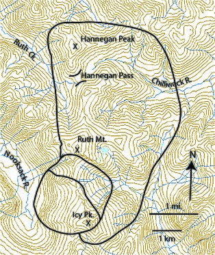
Outline map of Hannegan caldera in the North Cascades. Postcaldera plutons intrude the southwest portion of the caldera.
1415:
1236:
1826:
285:(1.15 million years old), and the numerous vents in the Mount Baker Volcanic field, including the currently active
1616:
Lanphere, M. A.; Champion, D. E.; Clynne, M. A.; Lowenstern, J. B.; Sarna-Wojcicki, A. M.; Wooden, J. L. (2004).
767:
1363:
1284:
23:
South face of Hannegan Peak from Hannegan Pass showing intracaldera structures. A 10-m breccia block is circled.
640:
361:
336:
1002:"Temporal and spatial evolution of Northern Cascade Arc magmatism revealed by LA–ICP–MS U–Pb zircon dating"
1524:
1472:
Poland, Michael P.; Lisowski, Michael; Dzurisin, Daniel; Kramer, Rebecca; McLay, Megan; Pauk, Ben (2017).
1241:
406:"Geology and complex collapse mechanisms of the 3.72 Ma Hannegan caldera, North Cascades, Washington, USA"
316:
1540:
1318:"Supplemental material: Eruptive history and geochronology of the Mount Baker volcanic field, Washington"
819:"Rhyodacites of Kulshan caldera, North Cascades of Washington: Postcaldera lavas that span the Jaramillo"
1178:
925:
916:
747:
140:
1182:
246:
Two granodiorite magma bodies invaded the Ruth Mountain ignimbrite, and are exposed today as a pair of
1164:
945:"Two-phase, reciprocal, double trapdoor collapse at Hannegan caldera, North Cascades, Washington, USA"
944:
818:
1629:
1590:
1551:
1485:
1419:
1351:
1272:
1070:
1013:
956:
830:
417:
698:"Geology and Mineral Resources of the Northern Part of the North Cascades National Park, Washington"
595:
99:
111:
1745:
1684:
1645:
1501:
1437:
1367:
1288:
1102:
1086:
982:
675:
520:
441:
191:
86:
47:
1403:
920:
1123:
Timing and Nature of Post-Collapse Sedimentation in Kulshan Caldera, North Cascades, Washington
614:
1710:
1473:
1317:
1135:
1094:
1039:
974:
869:
846:
797:
735:
727:
709:
667:
659:
587:
483:
433:
312:
298:
1001:
891:
1735:
1676:
1637:
1598:
1559:
1493:
1427:
1359:
1329:
1280:
1210:
1170:
1127:
1078:
1029:
1021:
964:
960:
838:
717:
512:
425:
373:
186:
115:
82:
864:
1218:
771:
282:
1000:
Mullen, Emily K.; Paquette, Jean-Louis; Tepper, Jeffrey H.; McCallum, I. Stewart (2018).
1633:
1594:
1555:
1489:
1423:
1355:
1276:
1074:
1017:
834:
421:
969:
145:
39:
19:
1058:
842:
817:
Hildreth, Wes; Lanphere, Marvin A.; Champion, Duane E.; Fierstein, Judy (2004-02-29).
1810:
1749:
1688:
1649:
1563:
1505:
1449:
1441:
1388:
1371:
1292:
986:
679:
524:
453:
445:
324:
182:
103:
95:
91:
1261:"Kulshan caldera: A Quaternary subglacial caldera in the North Cascades, Washington"
1106:
697:
575:
504:
54:
collapsed during two separate volcanic eruptions that produced as much as 140 km of
1445:
1384:
1185:
1149:
449:
267:
207:
Fossil Pliocene leaf, 8-cm-long, in intracaldera lake sediment in Hannegan caldera.
1704:
1541:"Eruptive history of Mount Mazama and Crater Lake Caldera, Cascade Range, U.S.A."
1144:
1664:
1641:
1458:
1381:
1302:
599:
462:
307:
306:, 8 x 10 km. The little known 600,000 year old Rockland caldera underlies
303:
286:
203:
1617:
1497:
1139:
1090:
532:
252:
156:
74:
61:
43:
1792:
1779:
1043:
978:
850:
757:
739:
437:
1714:
1602:
1222:
1098:
591:
320:
256:
217:
178:
1665:"Geology of the Coquihalla Volcanic Complex, southwestern British Columbia"
1025:
366:"Geologic Map of the Pliocene Hannegan Caldera, North Cascades, Washington"
1578:
790:"Geologic Map of the Mount Baker 30- by 60-Minute Quadrangle, Washington"
663:
377:
277:
107:
55:
1729:
1214:
1131:
713:
365:
247:
78:
51:
1740:
1174:
1034:
671:
546:
1432:
580:
Washington Division of Geology and Earth Resources Geologic Map GM-50
429:
161:
1680:
1334:
1189:
1121:
789:
516:
228:
1204:
1082:
477:
788:
Tabor, R. W.; Haugerud, R. A.; Hildreth, Wes; Brown, E.H. (2003).
722:
266:
227:
213:
202:
169:
155:
60:
18:
164:, pumice clasts flattened by compaction of hot pyroclastic flows.
1206:
Geology and Petrology of the Lake Ann Stock and Associated Rocks
731:
622:
Washington Division of Geology and Earth Resources Geologic Maps
174:
70:
796:(I-2660) (1 ed.). Menlo Park, CA: U.S. Geological Survey.
1520:"Geology and History Summary for Mount Mazama and Crater Lake"
160:
Welded tuff, or ignimbrite, on Hannegan Peak. Knife points to
38:
is a 3.72 million year old volcanic collapse structure in the
404:
Tucker, D.; Hildreth, W.; Ullrich, T.; Friedman, R. (2007).
1364:
10.1130/0016-7606(2003)115<0729:EHAGOT>2.0.CO;2
1285:
10.1130/0016-7606(1996)108<0786:kcaqsc>2.3.co;2
479:
Quaternary Magmatism in the Cascades: Geologic Perspectives
641:"Mines and Mineral Deposits of Whatcom County, Washington"
794:
U.S. Geological Survey Miscellaneous Investigation Series
509:
U.S. Geological Survey Scientific Investigations Map 2940
220:. These rocks contain fossil leaves, and remain undated.
94:. Prominent geographic points within the caldera include
547:"Mount Baker Volcano Research Center: Eruptive History"
949:
IOP Conference Series: Earth and Environmental Science
505:"Geologic Map of the North Cascade Range, Washington"
139:
The entire region has been deeply eroded by repeated
648:
Washington Division of Mines & Geology Bulletin
168:Around 4 million years ago large volumes rhyolitic
1663:Berman, Robert G.; Armstrong, Richard Lee (1980).
1057:Tepper, Jeffrey H.; Kuehner, Scott M. (May 2004).
482:. U.S. Geological Survey Professional Paper 1744.
1768:Geology of the North Cascades- A Mountain Mosaic
626:Washington State Department of Natural Resources
584:Washington State Department of Natural Resources
319:, (approx 6 x 6 km) and the 25 million year old
576:"Geologic map of Washington—Northwest quadrant"
1544:Journal of Volcanology and Geothermal Research
823:Journal of Volcanology and Geothermal Research
503:Haugerud, Ralph A.; Tabor, Rowland W. (2009).
85:. Rocks filling the caldera are lumped into a
1706:Geologic Field Trips in the Pacific Northwest
1237:"Geology and History Summary for Mount Baker"
8:
263:The end of volcanic activity in the caldera
656:Washington Department of Natural Resources
370:Geological Society of America Digital Maps
1739:
1618:"Age of the Rockland tephra, western USA"
1474:"Volcano geodesy in the Cascade arc, USA"
1431:
1402:Wells, Ray E.; McCaffrey, Robert (2013).
1333:
1209:(Thesis). Western Washington University.
1126:(Thesis). Western Washington University.
1033:
968:
721:
921:"Copper Ridge / Chilliwack River Trails"
26:
613:Schuster, J. Eric; et al. (2011).
348:
293:Comparison with other Cascades calderas
69:The caldera is filled with 55-60 km of
1344:Geological Society of America Bulletin
1322:Geological Society of America Bulletin
1265:Geological Society of America Bulletin
410:Geological Society of America Bulletin
120:Mount Baker-Snoqualmie National Forest
16:Geologic caldera in Washington (state)
1734:(Thesis). Portland State University.
1254:
1252:
938:
936:
118:. The caldera’s western margin is in
7:
1404:"Steady rotation of the Cascade arc"
1169:(Thesis). University of Washington.
783:
781:
691:
689:
399:
397:
395:
393:
391:
389:
387:
356:
354:
352:
135:Pre-caldera volcanism and topography
615:"Geologic Maps of Washington State"
551:Mount Baker Volcano Research Center
1669:Canadian Journal of Earth Sciences
1006:Canadian Journal of Earth Sciences
702:USGS Numbered Series Bulletin 1359
181:, cinder cones, and perhaps small
14:
511:. Scientific Investigations Map.
114:and the uppermost reaches of the
1183:f490cf1f3c2b316b1326e6a819b69707
122:but most of the structure is in
1822:Volcanoes of Washington (state)
1583:Journal of Geophysical Research
323:caldera (6x9 km) 40 km east of
242:Post-collapse pluton intrusions
1817:Calderas of Washington (state)
1120:Dennis Martin, Feeney (2008).
1:
1728:King, John Frederick (1994).
896:Washington Trails Association
843:10.1016/S0377-0273(03)00290-7
555:Western Washington University
1564:10.1016/0377-0273(83)90004-5
1203:James, Eric William (1980).
970:10.1088/1755-1307/3/1/012011
124:North Cascades National Park
1642:10.1016/j.yqres.2004.03.001
1577:Clynne, Michael A. (1990).
1843:
1539:Bacon, Charles R. (1983).
704:. U.S. Geological Survey:
1498:10.1007/s00445-017-1140-x
1163:Mullen, Emily K. (2011).
943:Tucker, David S. (2008).
865:"Hannegan Pass Trail 674"
110:, the western portion of
892:"Hannegan Pass and Peak"
199:Hiatus and sedimentation
1603:10.1029/JB095iB12p19651
1478:Bulletin of Volcanology
961:2008E&ES....3a2011T
772:ark:/67531/metadc304328
639:Moen, Wayne S. (1969).
337:Dave Tucker (geologist)
224:Second caldera collapse
1793:48.87333°N 121.50917°W
1525:U.S. Geological Survey
1316:Hildreth, Wes (2003).
1259:Hildreth, Wes (1996).
1242:U.S. Geological Survey
1063:The Journal of Geology
1026:10.1139/cjes-2017-0167
607:alma990020728850106761
476:Hildreth, Wes (2007).
317:Hope, British Columbia
273:
234:
208:
165:
152:First caldera collapse
66:
32:
24:
926:National Park Service
917:Olympic National Park
270:
231:
206:
159:
64:
30:
22:
1798:48.87333; -121.50917
1589:(B12): 19651–19669.
761:EPA National Library
748:NPS History eLibrary
378:10.1130/2006.dmch003
1789: /
1634:2004QuRes..62...94L
1622:Quaternary Research
1595:1990JGR....9519651C
1556:1983JVGR...18...57B
1490:2017BVol...79...59P
1424:2013Geo....41.1027W
1356:2003GSAB..115..729H
1277:1996GSAB..108..786H
1075:2004JG....112..349T
1018:2018CaJES..55..443M
835:2004JVGR..130..227H
603:MIT Libraries docid
422:2007GSAB..119..329T
81:, and post-caldera
1215:10.25710/r3dp-d443
1132:10.25710/0wqt-v628
919:(March 25, 2022).
274:
235:
209:
166:
87:stratigraphic unit
67:
33:
25:
1827:Cascade Volcanoes
1741:10.15760/etd.6649
870:US Forest Service
654:. United States:
489:978-1-4113-1945-5
187:pyroclastic flows
83:sedimentary rocks
1834:
1804:
1803:
1801:
1800:
1799:
1794:
1790:
1787:
1786:
1785:
1782:
1754:
1753:
1743:
1725:
1719:
1718:
1699:
1693:
1692:
1660:
1654:
1653:
1613:
1607:
1606:
1574:
1568:
1567:
1536:
1530:
1529:
1516:
1510:
1509:
1469:
1463:
1462:
1457:
1435:
1433:10.1130/G34514.1
1399:
1393:
1392:
1380:
1339:
1337:
1313:
1307:
1306:
1301:
1256:
1247:
1246:
1233:
1227:
1226:
1200:
1194:
1193:
1160:
1154:
1153:
1117:
1111:
1110:
1054:
1048:
1047:
1037:
997:
991:
990:
972:
940:
931:
930:
913:
907:
906:
904:
902:
888:
882:
881:
879:
877:
861:
855:
854:
814:
808:
807:
785:
776:
775:
756:
725:
693:
684:
683:
645:
636:
630:
629:
619:
610:
571:
565:
564:
562:
561:
543:
537:
536:
500:
494:
493:
473:
467:
466:
461:
430:10.1130/b25904.1
416:(3–4): 329–342.
401:
382:
381:
362:Tucker, David S.
358:
315:caldera east of
130:Geologic history
116:Chilliwack River
36:Hannegan caldera
1842:
1841:
1837:
1836:
1835:
1833:
1832:
1831:
1807:
1806:
1797:
1795:
1791:
1788:
1783:
1780:
1778:
1776:
1775:
1763:
1761:Further reading
1758:
1757:
1727:
1726:
1722:
1701:
1700:
1696:
1681:10.1139/e80-099
1662:
1661:
1657:
1615:
1614:
1610:
1576:
1575:
1571:
1538:
1537:
1533:
1518:
1517:
1513:
1471:
1470:
1466:
1455:
1401:
1400:
1396:
1378:
1341:
1335:10.1130/2003091
1315:
1314:
1310:
1299:
1258:
1257:
1250:
1235:
1234:
1230:
1202:
1201:
1197:
1162:
1161:
1157:
1119:
1118:
1114:
1056:
1055:
1051:
999:
998:
994:
942:
941:
934:
915:
914:
910:
900:
898:
890:
889:
885:
875:
873:
863:
862:
858:
816:
815:
811:
804:
787:
786:
779:
754:
695:
694:
687:
643:
638:
637:
633:
617:
612:
573:
572:
568:
559:
557:
545:
544:
540:
517:10.3133/SIM2940
502:
501:
497:
490:
475:
474:
470:
459:
403:
402:
385:
360:
359:
350:
345:
333:
295:
283:Kulshan caldera
265:
244:
226:
201:
192:radiometric age
183:stratovolcanoes
154:
137:
132:
17:
12:
11:
5:
1840:
1838:
1830:
1829:
1824:
1819:
1809:
1808:
1773:
1772:
1762:
1759:
1756:
1755:
1720:
1694:
1675:(8): 985–995.
1655:
1608:
1569:
1531:
1511:
1464:
1394:
1350:(6): 729–764.
1328:(6): 729–764.
1308:
1271:(7): 786–793.
1248:
1228:
1195:
1155:
1112:
1091:10.1086/382764
1083:10.1086/382764
1069:(3): 349–367.
1049:
1012:(5): 443–462.
992:
932:
908:
883:
856:
829:(3): 227–264.
809:
802:
777:
685:
631:
566:
538:
495:
488:
468:
383:
347:
346:
344:
341:
340:
339:
332:
329:
297:The few known
294:
291:
264:
261:
243:
240:
225:
222:
200:
197:
153:
150:
136:
133:
131:
128:
73:consisting of
40:North Cascades
15:
13:
10:
9:
6:
4:
3:
2:
1839:
1828:
1825:
1823:
1820:
1818:
1815:
1814:
1812:
1805:
1802:
1770:
1769:
1765:
1764:
1760:
1751:
1747:
1742:
1737:
1733:
1732:
1724:
1721:
1716:
1712:
1708:
1707:
1698:
1695:
1690:
1686:
1682:
1678:
1674:
1670:
1666:
1659:
1656:
1651:
1647:
1643:
1639:
1635:
1631:
1628:(1): 94–104.
1627:
1623:
1619:
1612:
1609:
1604:
1600:
1596:
1592:
1588:
1584:
1580:
1573:
1570:
1565:
1561:
1557:
1553:
1550:(1): 57–115.
1549:
1545:
1542:
1535:
1532:
1527:
1526:
1521:
1515:
1512:
1507:
1503:
1499:
1495:
1491:
1487:
1483:
1479:
1475:
1468:
1465:
1460:
1454:
1451:
1447:
1443:
1439:
1434:
1429:
1425:
1421:
1417:
1413:
1409:
1405:
1398:
1395:
1390:
1386:
1383:
1377:
1373:
1369:
1365:
1361:
1357:
1353:
1349:
1345:
1336:
1331:
1327:
1323:
1319:
1312:
1309:
1304:
1298:
1294:
1290:
1286:
1282:
1278:
1274:
1270:
1266:
1262:
1255:
1253:
1249:
1244:
1243:
1238:
1232:
1229:
1224:
1220:
1216:
1212:
1208:
1207:
1199:
1196:
1191:
1187:
1184:
1180:
1176:
1172:
1168:
1167:
1159:
1156:
1151:
1147:
1146:
1141:
1137:
1133:
1129:
1125:
1124:
1116:
1113:
1108:
1104:
1100:
1096:
1092:
1088:
1084:
1080:
1076:
1072:
1068:
1064:
1060:
1053:
1050:
1045:
1041:
1036:
1031:
1027:
1023:
1019:
1015:
1011:
1007:
1003:
996:
993:
988:
984:
980:
976:
971:
966:
962:
958:
955:(1): 012011.
954:
950:
946:
939:
937:
933:
928:
927:
922:
918:
912:
909:
897:
893:
887:
884:
872:
871:
866:
860:
857:
852:
848:
844:
840:
836:
832:
828:
824:
820:
813:
810:
805:
803:0-607-96870-2
799:
795:
791:
784:
782:
778:
773:
769:
766:
762:
759:
753:
749:
745:
741:
737:
733:
729:
724:
723:10.3133/b1359
719:
715:
711:
707:
703:
699:
692:
690:
686:
681:
677:
673:
669:
665:
661:
657:
653:
649:
642:
635:
632:
627:
623:
616:
608:
604:
601:
597:
593:
589:
585:
581:
577:
570:
567:
556:
552:
548:
542:
539:
534:
530:
526:
522:
518:
514:
510:
506:
499:
496:
491:
485:
481:
480:
472:
469:
464:
458:
455:
451:
447:
443:
439:
435:
431:
427:
423:
419:
415:
411:
407:
400:
398:
396:
394:
392:
390:
388:
384:
379:
375:
371:
367:
363:
357:
355:
353:
349:
342:
338:
335:
334:
330:
328:
326:
325:Mount Rainier
322:
318:
314:
309:
305:
300:
292:
290:
288:
284:
279:
269:
262:
260:
258:
254:
249:
241:
239:
230:
223:
221:
219:
215:
205:
198:
196:
193:
188:
184:
180:
176:
171:
163:
158:
151:
149:
147:
142:
134:
129:
127:
125:
121:
117:
113:
109:
105:
104:Ruth Mountain
101:
100:Hannegan Pass
97:
96:Hannegan Peak
93:
92:Mount Shuksan
88:
84:
80:
76:
72:
63:
59:
57:
53:
49:
45:
41:
37:
29:
21:
1774:
1767:
1730:
1723:
1705:
1697:
1672:
1668:
1658:
1625:
1621:
1611:
1586:
1582:
1572:
1547:
1543:
1534:
1523:
1514:
1481:
1477:
1467:
1446:ResearchGate
1411:
1407:
1397:
1385:ResearchGate
1347:
1343:
1325:
1321:
1311:
1268:
1264:
1240:
1231:
1205:
1198:
1165:
1158:
1150:Google Books
1145:ZNy0YgEACAAJ
1143:
1122:
1115:
1066:
1062:
1052:
1009:
1005:
995:
952:
948:
924:
911:
901:December 13,
899:. Retrieved
895:
886:
876:December 13,
874:. Retrieved
868:
859:
826:
822:
812:
793:
701:
651:
647:
634:
621:
579:
569:
558:. Retrieved
550:
541:
508:
498:
478:
471:
450:ResearchGate
413:
409:
369:
296:
275:
245:
236:
210:
167:
138:
112:Copper Ridge
77:, wall-rock
68:
35:
34:
1796: /
1784:121°30′33″W
765:1303 309115
744:Publication
308:Lassen Peak
304:Crater Lake
287:Mount Baker
141:continental
1811:Categories
1781:48°52′24″N
1175:1773/20946
1140:1030748593
1035:1807/87390
714:B000NEA2S8
560:2022-12-11
343:References
313:Coquihalla
253:ignimbrite
175:lava flows
75:ignimbrite
48:Washington
44:U.S. state
1750:134176687
1689:129826748
1650:140689415
1506:133965157
1484:(8): 59.
1450:256082766
1442:129510320
1416:1027–1030
1389:249526873
1372:140538576
1293:129795941
1223:13589973M
1044:0008-4077
987:250683520
979:1755-1315
851:0377-0273
740:768876024
680:128474733
525:128560085
454:249527328
446:128417330
438:0016-7606
321:Mount Aix
278:andesitic
257:Batholith
218:sandstone
1715:35377547
1459:70117449
1382:70025620
1303:70018518
1190:75469235
1186:Academia
1179:ProQuest
1107:43130146
1099:98228216
732:72600151
592:50325812
463:70032860
364:(2006).
331:See also
289:itself.
108:Icy Peak
56:rhyolite
42:of the
1630:Bibcode
1591:Bibcode
1552:Bibcode
1486:Bibcode
1420:Bibcode
1408:Geology
1352:Bibcode
1273:Bibcode
1071:Bibcode
1014:Bibcode
957:Bibcode
831:Bibcode
768:UNT key
746:at the
672:5309872
600:5683968
533:4761905
418:Bibcode
299:Cascade
248:plutons
79:breccia
52:caldera
1748:
1713:
1687:
1648:
1504:
1456:
1440:
1379:
1370:
1300:
1291:
1221:
1181:
1138:
1105:
1097:
1089:
1042:
985:
977:
849:
800:
755:
738:
730:
712:
678:
670:
662:
596:Catkey
590:
531:
523:
486:
460:
444:
436:
233:scale.
162:fiamme
50:. The
1746:S2CID
1685:S2CID
1646:S2CID
1502:S2CID
1438:S2CID
1414:(9):
1368:S2CID
1289:S2CID
1103:S2CID
1087:JSTOR
983:S2CID
758:b1359
706:1-132
676:S2CID
664:75702
644:(PDF)
618:(PDF)
521:S2CID
442:S2CID
272:left.
214:shale
179:domes
170:magma
146:dikes
58:ash.
1711:OCLC
1453:USGS
1376:USGS
1297:USGS
1136:OCLC
1095:OCLC
1040:ISSN
975:ISSN
903:2022
878:2022
847:ISSN
798:ISBN
752:USGS
736:OCLC
728:LCCN
710:ASIN
668:OSTI
660:OCLC
588:OCLC
484:ISBN
457:USGS
434:ISSN
216:and
177:and
71:tuff
1736:doi
1677:doi
1638:doi
1599:doi
1560:doi
1494:doi
1428:doi
1360:doi
1348:115
1340:In
1330:doi
1326:115
1281:doi
1269:108
1211:doi
1171:hdl
1148:at
1128:doi
1079:doi
1067:112
1030:hdl
1022:doi
965:doi
839:doi
827:130
718:doi
611:In
529:NLA
513:doi
426:doi
414:119
374:doi
46:of
1813::
1744:.
1683:.
1673:17
1671:.
1667:.
1644:.
1636:.
1626:62
1624:.
1620:.
1597:.
1587:95
1585:.
1581:.
1558:.
1548:18
1546:.
1522:.
1500:.
1492:.
1482:79
1480:.
1476:.
1444:.
1436:.
1426:.
1418:.
1412:41
1410:.
1406:.
1374:.
1366:.
1358:.
1346:.
1324:.
1320:.
1295:.
1287:.
1279:.
1267:.
1263:.
1251:^
1239:.
1219:OL
1217:.
1177:.
1142:.
1134:.
1101:.
1093:.
1085:.
1077:.
1065:.
1061:.
1038:.
1028:.
1020:.
1010:55
1008:.
1004:.
981:.
973:.
963:.
951:.
947:.
935:^
923:.
894:.
867:.
845:.
837:.
825:.
821:.
792:.
780:^
750:.
742:.
734:.
726:.
716:.
708:.
700:.
688:^
674:.
666:.
658:.
652:57
650:.
646:.
624:.
620:.
594:.
586:.
582:.
578:.
553:.
549:.
527:.
519:.
507:.
448:.
440:.
432:.
424:.
412:.
408:.
386:^
372:.
368:.
351:^
327:.
106:,
102:,
98:,
1752:.
1738::
1717:.
1691:.
1679::
1652:.
1640::
1632::
1605:.
1601::
1593::
1566:.
1562::
1554::
1528:.
1508:.
1496::
1488::
1461:.
1448::
1430::
1422::
1391:.
1387::
1362::
1354::
1338:.
1332::
1305:.
1283::
1275::
1245:.
1225:.
1213::
1192:.
1188::
1173::
1152:.
1130::
1109:.
1081::
1073::
1046:.
1032::
1024::
1016::
989:.
967::
959::
953:3
929:.
905:.
880:.
853:.
841::
833::
806:.
774:.
770::
763::
720::
682:.
628:.
609:.
605::
598::
563:.
535:.
515::
492:.
465:.
452::
428::
420::
380:.
376::
Text is available under the Creative Commons Attribution-ShareAlike License. Additional terms may apply.