55:
243:
375:
1727:
1713:
256:
The central basin receives an average of 6 inches (150 mm) of rain per year, with the surrounding mountains receiving an average of 15 inches (380 mm) per year. The center of the basin is flat and contains
Malheur and Harney lakes, which receive the streams originating within the basin in
425:
basin, indicating that at some point the Harney Basin may have been connected to the
Columbia. During wetter years, the lake level of Malheur Lake was raised to a depth of 25 feet (7.6 m), allowing the lakes to drain over the Malheur Gap. In modern times, however, the lake level does not rise
67:
488:
The basin has a widespread decline in groundwater which has put the region at risk of ecological and economic collapse. Irrigation pumping is dropping the water table as much as 10 feet (3.0 m) every year in one area.
468:
Because of its climate, it received sparse white settlements and was largely left to the Paiute until the late 19th century. Settlement pressures and conflicts with the Paiute in other areas of Oregon caused
President
405:
evidence indicates the basin was inhabited as early as 10,000 years ago. Pollen records indicate that the climate, especially the level of rain and snowfall, has varied greatly since the end of the
1287:
984:
303:
in the plain north of
Malheur Lake is the only community with a population larger than 1,000. Dryland ranching is the basis of the area's economy, with relatively little
1758:
1292:
409:. Evidence of prehistoric fishing techniques is found at several sites. Evidence suggests that there existed in the basin several species—in particular, the
1763:
828:
485:
to abruptly terminate the reservation in 1879. The
Northern Paiute would survive virtually landless until obtaining tracts of land near Burns in 1935.
343:
watershed of 765 sq mi (1,980 km) discharges into
Malheur Lake and includes the river portion of the 292 sq mi (760 km)
635:
580:
552:
265:
from the south. Harney Lake is the actual sink of the basin, connected in some years to
Malheur Lake but currently separated by constantly changing
1753:
359:
355:
269:. Both lakes cycle between open water in wetter years and marshes in drier years. The wetlands around Malheur Lake and Harney Lake form a
105:
1320:
543:
1315:
1153:
215:
31:
932:
891:
344:
286:
736:
548:
660:
1018:
989:
924:
482:
336:
1768:
1055:
854:
691:
A tale of two basins: Comparisons and contrasts in the high desert hydrogeology of Steens
Mountain, southeastern Oregon,
98:
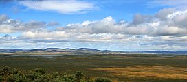
1006:
1513:
1040:
1035:
1028:
606:
481:
in the surrounding mountains, as well as the interest of white settlers to form ranches in the region, caused the
1686:
1586:
1126:
957:
296:
639:
1731:
1661:
1646:
1601:
1596:
1561:
1531:
1330:
1279:
967:
756:
340:
262:
188:
141:
35:
566:
563:
538:
477:
encompassing
Malheur Lake and much of the basin. Growing settlement pressures, in particular the discovery of
349:
Alkali Field is located directly south of
Malheur Lake, a few kilometers east of the Donner und Blitzen River.
1666:
1541:
962:
859:
438:
231:
54:
1696:
1691:
1676:
1656:
1631:
1621:
1606:
1591:
1571:
1566:
1536:
1045:
979:
577:
462:
226:
to the southeast. No streams cross the volcanic plains that separate the basin from the watershed of the
1641:
1636:
1581:
1526:
1488:
1463:
1265:
1106:
450:
379:
362:
wetlands with 1,651 sq mi (4,280 km) in Oregon, including a large area around Harney and
292:
192:
242:
1681:
1671:
1576:
1556:
1551:
1521:
1483:
1443:
1240:
1186:
974:
884:
1651:
1626:
1616:
1611:
1546:
1453:
1418:
1413:
1408:
1398:
1378:
1301:
1260:
994:
474:
66:
1116:
1111:
1101:
1071:
1001:
796:, "Climatic changes in the western United States since 18,000 yr B.P." in Herbert Edgar Wright,
454:
418:
390:
705:"Boundary Descriptions and Names of Regions, Subregions, Accounting Units and Cataloging Units"
203:
plain. The basin encompasses an area of 1,490 square miles (3,859 km) in the watershed of
1503:
1498:
1473:
1433:
1383:
1363:
1358:
1163:
1091:
1076:
1050:
1013:
942:
937:
693:
Geological Society of America, Field Guides, 2009, 15, p. 295-318, doi:10.1130/2009.fld015(15)
688:
374:
461:. A total of 23 people died while the party wandered in the basin until finding water at the
1478:
1458:
1438:
1428:
1338:
1250:
1143:
470:
196:
17:
1468:
1448:
1423:
1373:
1353:
1310:
1306:
1211:
1196:
1158:
1081:
952:
877:
584:
430:
394:
250:
246:
219:
172:
199:—within which it is contained, physiographically speaking—and on the south and west by a
1403:
1393:
1388:
1348:
1297:
1245:
1201:
1173:
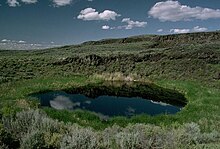
1135:
498:
422:
402:
39:
725:
1747:
1717:
1493:
1343:
1235:
914:
398:
320:
300:
258:
227:
223:
180:
145:
780:
Texaco Basin was surveyed by Thomas, Goheen and Loring on August 13, 19 and 20, 1980
1368:
1219:
1148:
1023:
668:
446:
442:
414:
363:
204:
159:
829:"Race to the bottom: How big business took over Oregon's first protected aquifer"
1255:
458:
410:
406:
208:
184:
155:
900:
319:
is a series of volcanic flows of rhyolite and of tuffs of ash flows in around
304:
732:
120:
107:
434:
266:
704:
517:
211:. Malheur Lake is a freshwater lake, while Harney Lake is saline-alkaline.
270:
864:
764:
614:
378:
Restoration of the volcanic eruption in Harney Basin represented by the
1191:
596:
Google Earth: bbs.keyhole.com/ubb/placemarks/cl-03-20-06-980475833.kmz
274:
200:
1096:
1086:
947:
904:
667:. Oregon Department of Geology and Mineral Industries. Archived from
176:
578:
GREATER HARNEY BASIN AGRICULTURAL WATER QUALITY MANAGEMENT AREA PLAN
869:
373:
241:
230:
to the southwest. The basin includes archeological sites of the
478:
386:
282:
278:
873:
285:
each year. Malheur Lake and its surroundings are embraced by
214:
The basin is bounded on the north by the southern end of the
815:
Where Land & Water Meet: A Western Landscape Transformed
689:
Michael L. Cummings, Sherry L. Cady, and Robert B. Perkins,
855:
USFWS: Archaeology in the Malheur National Wildlife Refuge
307:
water available from the streams that enter Malheur Lake.
429:
In the 19th century, the basin was inhabited by the
385:
The basin was formed approximately 32,000 years ago when
636:"2010 Demographic Profile Data: Harney County, Oregon"
518:"Query Form For The United States And Its Territories"
323:. The field is within the High Lava Plains Province.
441:
in the 1820s. The basin lay far off the route of the
1512:
1329:
1278:
1228:
1210:
1172:
1134:
1125:
1064:
923:
151:
137:
97:
92:
84:
76:
47:
433:tribe. It was explored and extensively trapped by
426:above 10 feet (3.0 m) in the wettest years.
802:Global Climates Since the Last Glacial Maximum
757:"Harney County Oregon, Range Seeding Projects"
607:"Harney County Oregon, Range Seeding Projects"
222:separates the basin from the watershed of the
885:
8:
726:"Harney-Malhuer Lakes Watershed -- 17120001"
449:led an ill-fated party across the basin via
335:is a 1,420 sq mi (3,700 km)
1131:
892:
878:
870:
187:. One of the least populated areas of the
71:The Harney Basin (dashed yellow perimeter)
44:
295:, had a total population of 7,422 at the
257:the surrounding mountains, including the
553:United States Department of the Interior
27:Endorheic basin in Oregon, United States
509:
445:, but in 1845 experienced mountain man
195:, bounded on the north and east by the
1759:Structural basins of the United States
827:Cook, Emily Cureton (March 16, 2022).
564:Harney Valley (1132040, also a basin),
421:—that are currently found only in the
88:3,855 km (1,488 sq mi)
7:
638:. U.S. Census Bureau. Archived from
281:species, including 2.5 million
191:, it is located largely in northern
544:Geographic Names Information System
457:along what has become known as the
1764:Geography of Harney County, Oregon
611:Archaeology: Harney County, Oregon
401:, a tributary of the Snake River.
183:at the northwestern corner of the
32:United States physiographic region
25:
1725:
1711:
813:Nancy Langston, William Cronon,
665:Oregon Geologic Data Compilation
520:. U.S. Board on Geographic Names
345:Malheur National Wildlife Refuge
287:Malheur National Wildlife Refuge
273:oasis in the basin, providing a
65:
53:
737:Environmental Protection Agency
549:United States Geological Survey
59:Harney Basin near Burns, Oregon
1754:Archaeological sites in Oregon
763:. AJMorris.com. Archived from
483:Commissioner of Indian Affairs
356:High Desert Wetlands ecoregion
333:Harney-Malheur Lakes watershed
327:Harney-Malheur Lakes watershed
1:
865:John Day Fossil Beds: History
860:Oregon Magazine: Harney Basin
1732:Pacific Northwest portal
80:4,111 ft (1,253 m)
587:(pdf), p. 15 & p. 17ff.
317:Harney Basin Volcanic Field
311:Harney Basin Volcanic Field
34:north of this basin in the
18:Harney Basin Volcanic Field
1785:
833:Oregon Public Broadcasting
475:reservation for the Paiute
29:
1705:
911:
64:
52:
792:See Robert S. Thompson,
661:"Stratigraphy Theme Key"
539:"Harney Basin (1132071)"
453:, seeking a shortcut to
360:Northern Basin and Range
341:Donner und Blitzen River
263:Donner und Blitzen River
189:contiguous United States
142:Donner und Blitzen River
36:Basin and Range Province
261:from the north and the
397:of the basin from the
382:
253:
121:43.25389°N 118.71500°W
1266:Trout Creek Mountains
817:2006:135 and note 66.
761:Archaeological Report
733:"Surf Your Watershed"
567:Malheur Gap (1123708)
380:Rattlesnake Formation
377:
337:Great Basin watershed
293:Harney County, Oregon
245:
232:Drewsey Resource Area
473:in 1872 to create a
439:Hudson's Bay Company
415:coarse-scale suckers
126:43.25389; -118.71500
1769:Volcanoes of Oregon
1261:Mount Hood Corridor
277:for many migratory
117: /
583:2008-06-26 at the
451:Stinkingwater Pass
419:northern squawfish
383:
254:
1741:
1740:
1718:Oregon portal
1274:
1273:
1164:Willamette Valley
393:, separating the
389:flows formed the
165:
164:
16:(Redirected from
1776:
1730:
1729:
1728:
1716:
1715:
1714:
1288:Albany–Corvallis
1251:Columbia Plateau
1144:Northwest Oregon
1132:
894:
887:
880:
871:
843:
842:
840:
839:
824:
818:
811:
805:
790:
784:
783:
776:
775:
769:
753:
747:
746:
744:
743:
729:
722:
716:
715:
713:
712:
701:
695:
686:
680:
679:
677:
676:
657:
651:
650:
648:
647:
632:
626:
625:
623:
622:
613:. Archived from
603:
597:
594:
588:
575:
569:
562:
560:
559:
535:
529:
528:
526:
525:
514:
471:Ulysses S. Grant
339:. The adjacent
197:Columbia Plateau
175:in southeastern
132:
131:
129:
128:
127:
122:
118:
115:
114:
113:
110:
69:
57:
45:
21:
1784:
1783:
1779:
1778:
1777:
1775:
1774:
1773:
1744:
1743:
1742:
1737:
1726:
1724:
1712:
1710:
1701:
1508:
1325:
1293:Bend–Prineville
1270:
1224:
1206:
1197:Treasure Valley
1168:
1159:Tualatin Valley
1121:
1060:
990:ballot measures
919:
907:
898:
851:
846:
837:
835:
826:
825:
821:
812:
808:
791:
787:
773:
771:
767:
755:
754:
750:
741:
739:
731:
724:
723:
719:
710:
708:
703:
702:
698:
687:
683:
674:
672:
659:
658:
654:
645:
643:
634:
633:
629:
620:
618:
605:
604:
600:
595:
591:
585:Wayback Machine
576:
572:
557:
555:
537:
536:
532:
523:
521:
516:
515:
511:
507:
495:
431:Northern Paiute
372:
329:
313:
251:Diamond, Oregon
240:
220:Steens Mountain
218:. The ridge of
173:endorheic basin
125:
123:
119:
116:
111:
108:
106:
104:
103:
77:Floor elevation
72:
60:
43:
28:
23:
22:
15:
12:
11:
5:
1782:
1780:
1772:
1771:
1766:
1761:
1756:
1746:
1745:
1739:
1738:
1736:
1735:
1721:
1706:
1703:
1702:
1700:
1699:
1694:
1689:
1684:
1679:
1674:
1669:
1664:
1659:
1654:
1649:
1644:
1639:
1634:
1629:
1624:
1619:
1614:
1609:
1604:
1599:
1594:
1589:
1584:
1579:
1574:
1569:
1564:
1559:
1554:
1549:
1544:
1539:
1534:
1529:
1524:
1518:
1516:
1510:
1509:
1507:
1506:
1501:
1496:
1491:
1486:
1481:
1476:
1471:
1466:
1461:
1456:
1451:
1446:
1441:
1436:
1431:
1426:
1421:
1416:
1411:
1406:
1401:
1396:
1391:
1386:
1381:
1376:
1371:
1366:
1361:
1356:
1351:
1346:
1341:
1335:
1333:
1331:Largest cities
1327:
1326:
1324:
1323:
1318:
1313:
1304:
1295:
1290:
1284:
1282:
1276:
1275:
1272:
1271:
1269:
1268:
1263:
1258:
1253:
1248:
1246:Columbia River
1243:
1241:Columbia Gorge
1238:
1232:
1230:
1226:
1225:
1223:
1222:
1216:
1214:
1208:
1207:
1205:
1204:
1202:Central Oregon
1199:
1194:
1189:
1184:
1178:
1176:
1170:
1169:
1167:
1166:
1161:
1156:
1154:Portland Metro
1151:
1146:
1140:
1138:
1129:
1123:
1122:
1120:
1119:
1114:
1109:
1104:
1099:
1094:
1089:
1084:
1079:
1074:
1068:
1066:
1062:
1061:
1059:
1058:
1053:
1048:
1043:
1038:
1033:
1032:
1031:
1026:
1021:
1011:
1010:
1009:
999:
998:
997:
992:
987:
982:
972:
971:
970:
965:
960:
955:
945:
940:
935:
929:
927:
921:
920:
912:
909:
908:
899:
897:
896:
889:
882:
874:
868:
867:
862:
857:
850:
849:External links
847:
845:
844:
819:
806:
785:
748:
717:
696:
681:
652:
627:
598:
589:
570:
530:
508:
506:
503:
502:
501:
499:Oregon Outback
494:
491:
423:Columbia River
403:Archaeological
371:
368:
328:
325:
312:
309:
239:
236:
216:Blue Mountains
163:
162:
153:
149:
148:
139:
135:
134:
101:
95:
94:
90:
89:
86:
82:
81:
78:
74:
73:
70:
62:
61:
58:
50:
49:
40:Harney section
26:
24:
14:
13:
10:
9:
6:
4:
3:
2:
1781:
1770:
1767:
1765:
1762:
1760:
1757:
1755:
1752:
1751:
1749:
1734:
1733:
1722:
1720:
1719:
1708:
1707:
1704:
1698:
1695:
1693:
1690:
1688:
1685:
1683:
1680:
1678:
1675:
1673:
1670:
1668:
1665:
1663:
1660:
1658:
1655:
1653:
1650:
1648:
1645:
1643:
1640:
1638:
1635:
1633:
1630:
1628:
1625:
1623:
1620:
1618:
1615:
1613:
1610:
1608:
1605:
1603:
1600:
1598:
1595:
1593:
1590:
1588:
1585:
1583:
1580:
1578:
1575:
1573:
1570:
1568:
1565:
1563:
1560:
1558:
1555:
1553:
1550:
1548:
1545:
1543:
1540:
1538:
1535:
1533:
1530:
1528:
1525:
1523:
1520:
1519:
1517:
1515:
1511:
1505:
1502:
1500:
1497:
1495:
1492:
1490:
1489:Central Point
1487:
1485:
1482:
1480:
1477:
1475:
1472:
1470:
1467:
1465:
1464:Klamath Falls
1462:
1460:
1457:
1455:
1452:
1450:
1447:
1445:
1442:
1440:
1437:
1435:
1432:
1430:
1427:
1425:
1422:
1420:
1417:
1415:
1412:
1410:
1407:
1405:
1402:
1400:
1397:
1395:
1392:
1390:
1387:
1385:
1382:
1380:
1377:
1375:
1372:
1370:
1367:
1365:
1362:
1360:
1357:
1355:
1352:
1350:
1347:
1345:
1342:
1340:
1337:
1336:
1334:
1332:
1328:
1322:
1319:
1317:
1314:
1312:
1308:
1305:
1303:
1299:
1296:
1294:
1291:
1289:
1286:
1285:
1283:
1281:
1277:
1267:
1264:
1262:
1259:
1257:
1254:
1252:
1249:
1247:
1244:
1242:
1239:
1237:
1234:
1233:
1231:
1227:
1221:
1218:
1217:
1215:
1213:
1209:
1203:
1200:
1198:
1195:
1193:
1190:
1188:
1185:
1183:
1180:
1179:
1177:
1175:
1171:
1165:
1162:
1160:
1157:
1155:
1152:
1150:
1147:
1145:
1142:
1141:
1139:
1137:
1133:
1130:
1128:
1124:
1118:
1115:
1113:
1110:
1108:
1105:
1103:
1100:
1098:
1095:
1093:
1090:
1088:
1085:
1083:
1080:
1078:
1075:
1073:
1070:
1069:
1067:
1063:
1057:
1054:
1052:
1049:
1047:
1044:
1042:
1039:
1037:
1034:
1030:
1027:
1025:
1022:
1020:
1017:
1016:
1015:
1012:
1008:
1005:
1004:
1003:
1000:
996:
993:
991:
988:
986:
983:
981:
978:
977:
976:
973:
969:
966:
964:
961:
959:
956:
954:
951:
950:
949:
946:
944:
941:
939:
936:
934:
931:
930:
928:
926:
922:
917:
916:
910:
906:
902:
895:
890:
888:
883:
881:
876:
875:
872:
866:
863:
861:
858:
856:
853:
852:
848:
834:
830:
823:
820:
816:
810:
807:
803:
799:
795:
789:
786:
782:
781:
770:on 2010-09-17
766:
762:
758:
752:
749:
738:
734:
727:
721:
718:
706:
700:
697:
694:
692:
685:
682:
671:on 2010-11-27
670:
666:
662:
656:
653:
642:on 2020-02-13
641:
637:
631:
628:
617:on 2011-01-03
616:
612:
608:
602:
599:
593:
590:
586:
582:
579:
574:
571:
568:
565:
554:
550:
546:
545:
540:
534:
531:
519:
513:
510:
504:
500:
497:
496:
492:
490:
486:
484:
480:
476:
472:
466:
464:
463:Crooked River
460:
456:
452:
448:
444:
440:
436:
432:
427:
424:
420:
416:
412:
408:
404:
400:
399:Malheur River
396:
392:
388:
381:
376:
369:
367:
365:
364:Malheur Lakes
361:
357:
352:
350:
346:
342:
338:
334:
326:
324:
322:
321:Burns, Oregon
318:
310:
308:
306:
302:
298:
294:
290:
288:
284:
280:
276:
272:
268:
264:
260:
259:Silvies River
252:
248:
244:
237:
235:
233:
229:
228:Klamath River
225:
224:Alvord Desert
221:
217:
212:
210:
206:
202:
198:
194:
193:Harney County
190:
186:
182:
181:United States
178:
174:
170:
161:
157:
154:
150:
147:
146:Silvies River
143:
140:
136:
130:
102:
100:
96:
91:
87:
83:
79:
75:
68:
63:
56:
51:
46:
41:
37:
33:
19:
1723:
1709:
1484:Happy Valley
1444:Forest Grove
1321:Salem–Keizer
1236:The Cascades
1220:Rogue Valley
1182:Harney Basin
1181:
1149:Oregon Coast
1087:Demographics
1024:Oregon Trail
1019:bibliography
980:constitution
913:
836:. Retrieved
832:
822:
814:
809:
801:
797:
793:
788:
779:
778:
772:. Retrieved
765:the original
760:
751:
740:. Retrieved
720:
709:. Retrieved
699:
690:
684:
673:. Retrieved
669:the original
664:
655:
644:. Retrieved
640:the original
630:
619:. Retrieved
615:the original
610:
601:
592:
573:
556:. Retrieved
542:
533:
522:. Retrieved
512:
487:
467:
447:Stephen Meek
443:Oregon Trail
428:
384:
358:is a set of
353:
348:
332:
330:
316:
314:
291:
255:
247:Malheur Maar
213:
205:Malheur Lake
169:Harney Basin
168:
166:
160:Malheur Lake
48:Harney Basin
1454:Wilsonville
1419:McMinnville
1414:Oregon City
1409:Grants Pass
1399:Lake Oswego
1379:Springfield
1302:Springfield
1280:Metro areas
1256:Great Basin
1187:High Desert
1107:LGBT rights
985:delegations
459:Meek Cutoff
411:chiselmouth
407:Pleistocene
391:Malheur Gap
297:2010 census
209:Harney Lake
185:Great Basin
156:Harney Lake
124: /
112:118°42′54″W
99:Coordinates
1748:Categories
1687:Washington
1587:Hood River
1051:State Fair
975:Government
838:2022-03-16
774:2010-05-26
742:2010-05-07
711:2010-05-26
707:. USGS.gov
675:2010-12-26
646:2015-03-21
621:2010-12-25
558:2010-05-26
524:2010-05-13
505:References
455:The Dalles
305:irrigation
267:sand dunes
109:43°15′14″N
1662:Tillamook
1647:Multnomah
1602:Josephine
1597:Jefferson
1562:Deschutes
1532:Clackamas
1504:Pendleton
1499:Hermiston
1474:Milwaukie
1434:West Linn
1384:Corvallis
1364:Beaverton
1359:Hillsboro
1097:Education
995:elections
948:Geography
918:(capital)
395:watershed
238:Geography
93:Geography
1667:Umatilla
1542:Columbia
1514:Counties
1479:Sherwood
1459:Roseburg
1439:Woodburn
1429:Tualatin
1339:Portland
1316:Portland
1212:Southern
1117:Politics
1112:Gambling
1102:Gun laws
1072:Abortion
1046:Pioneers
1029:timeline
1002:Governor
581:Archived
493:See also
435:trappers
271:wetlands
201:volcanic
30:For the
1697:Yamhill
1692:Wheeler
1677:Wallowa
1657:Sherman
1632:Malheur
1622:Lincoln
1607:Klamath
1592:Jackson
1572:Gilliam
1567:Douglas
1537:Clatsop
1469:Ashland
1449:Newberg
1424:Redmond
1374:Medford
1354:Gresham
1311:Ashland
1307:Medford
1192:Palouse
1174:Eastern
1136:Western
1127:Regions
1092:Economy
1077:Culture
1065:Society
1056:Symbols
1014:History
958:beaches
943:Climate
938:Outline
768:(p. 23)
437:of the
370:History
275:habitat
179:in the
133:
1642:Morrow
1637:Marion
1582:Harney
1527:Benton
1404:Keizer
1394:Tigard
1389:Albany
1349:Eugene
1298:Eugene
1229:Shared
1041:People
968:rivers
925:Topics
905:Oregon
798:et al.
794:et al.
417:, and
299:, and
177:Oregon
171:is an
38:, see
1682:Wasco
1672:Union
1577:Grant
1557:Curry
1552:Crook
1522:Baker
1494:Canby
1344:Salem
1082:Crime
1036:Parks
963:lakes
953:fauna
933:Index
915:Salem
901:State
804:1993.
800:eds.
301:Burns
283:ducks
249:near
138:River
1652:Polk
1627:Linn
1617:Lane
1612:Lake
1547:Coos
1369:Bend
1007:list
479:gold
387:lava
354:The
347:. "
331:The
315:The
279:bird
207:and
167:The
152:Lake
85:Area
903:of
1750::
831:.
777:.
759:.
735:.
730:,
663:.
609:.
551:,
547:.
541:.
465:.
413:,
366:.
351:"
289:.
234:.
158:;
144:;
1309:–
1300:–
893:e
886:t
879:v
841:.
745:.
728:.
714:.
678:.
649:.
624:.
561:.
527:.
42:.
20:)
Text is available under the Creative Commons Attribution-ShareAlike License. Additional terms may apply.