51:
1238:
1136:
515:
older. The population was divided into 15,039 households, with an average size of 4.4 persons. 34% of households had a female head of house, while 66% had a male. For those 15 years and older, 54% had never married, 30% married with certificate, 1% married traditionally, 9% married consensually, 2% were divorced or separated, and 4% were widowed.
502:
530:(44%). For those 15 years and older, the literacy rate was 83%. Nearly half of the population are from coloured and white Namibian groups. In terms of education, 84% of girls and 83% of boys between the ages of 6–15 were attending school, and of those older than 15, 73% had left school, 9% were currently at school, and 13% had never attended.
190:
548:
For every 1000 live births there were 62 female infant deaths and 64 male. The life expectancy at birth was 53 years for females and 51 for males. Among children younger than 15, 4% had lost a mother, 6% a father, and 1% were orphaned by both parents. 6% of the entire population had a disability, of
533:
In 2001 the employment rate for the labor force (64% of those 15+) was 66% employed and 34% unemployed. For those 15+ years old and not in the labor force (29%), 29% were students, 37% home-makers, and 33% retired, too old, etc. According to the 2012 Namibia Labour Force Survey, unemployment in the
514:
was 3.6 children per woman. 46% lived in urban areas while 54% lived in rural areas, and with an area of 109,651 km, the population density was 0.6 persons per km. By age, 13% of the population was under 5 years old, 23% between 5 and 14 years, 55% between 15 and 59 years, and 8% 60 years and
815:
545:, and 20% had wood or charcoal for cooking. In terms of household's main sources of income, 9% derived it from farming, 61% from wages and salaries, 7% cash remittances, 5% from business or non-farming, and 15% from pension.
509:
According to the
Namibia 2001 Population and Housing Census, Hardap had a population of 68,249 (33,665 females and 34,579 males or 103 males for every 100 females) growing at an annual rate of 0.3%. The
1167:
823:
975:
1299:
162:
1160:
866:
1153:
1040:
772:
648:
445:
453:
449:
434:
746:
1304:
985:
457:
1004:
Hardap
Regional Poverty Profile: based on village-level participatory poverty assessments in Hardap Region, Namibia: October 2005-February 2006
460:(LPM, an opposition party formed in 2016) was the strongest party. It obtained 45% of votes overall and won seven of the eight constituencies.
389:
of
Namibia for declaring Hardap Region "SWAPO territory" and urging supporters not to allow other political parties to "invade" the region.
1250:
386:
1033:
50:
819:
720:
549:
which 19% were deaf, 47% blind, 7% had a speech disability, 10% hand disability, 28% leg disability, and 6% mental disability.
398:
493:
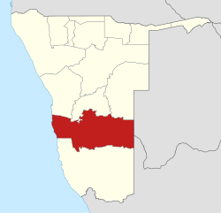
Hardap has 55 schools with a total of 21,886 pupils. The region has good infrastructure with well-developed road networks.
422:
438:
1294:
1026:
891:
452:: 60%) and won seven of the eight constituencies with only Rehoboth Urban West narrowly won by the opposition. In the
949:
776:
659:
325:
207:
211:
749:. Windhoek, Namibia: NamRights (National Society for Human Rights (Namibia)). 22 February 2009. Archived from
750:
382:
150:
1289:
870:
801:
469:
414:
846:
620:
1227:
1222:
1202:
1192:
1120:
712:
481:
402:
363:
358:
353:
333:
142:
92:
1197:
1145:
1049:
475:
369:
275:
227:
223:
77:
41:
1007:
923:
Miyanicwe, Clemans; Kahiurika, Ndanki (27 November 2013). "School counsellors overstretched".
231:
201:
1095:
1070:
312:
1212:
1207:
1115:
527:
418:
343:
338:
239:
197:
1217:
1125:
1105:
1100:
791:"Electoral Act, 1992: Notification of Result of General Election for Regional Councils"
511:
348:
271:
585:
1283:
1110:
1090:
1085:
1060:
523:
300:
294:
283:
1080:
1075:
980:
925:
896:
851:
590:
534:
Hardap Region stood at 28.8%. The two studies are methodologically not comparable.
287:
274:
in the west to
Namibia's eastern national border. In the northeast, it borders the
255:
901:
683:
1237:
1135:
538:
410:
259:
1265:
1252:
1011:
324:
As of 2020, Hardap had 52,534 registered voters. The region comprises eight
17:
519:
251:
133:
790:
953:
279:
247:
1181:
306:
67:
56:
541:, 34% no toilet facility, 51% electricity for lighting, 77% access to
501:
1018:
385:. In February 2009, then-governor Hanse-Himarwa was condemned by the
243:
235:
138:
542:
500:
406:
378:
409:
with a narrow absolute majority of the votes (52%), following by
1149:
1022:
230:. Hardap contains the municipality of Mariental, the towns
649:"2023 Population & Housing Census Preliminary Report"
558:
505:
Hardap Dam, outside of
Mariental, at sunrise in April 2008
173:
724:
270:
Hardap stretches the entire width of
Namibia, from the
952:. National Planning Commission. 2001. Archived from
684:"Sub-national HDI - Area Database - Global Data Lab"
609:(1). Institute for Public Policy Research: 3. 2013.
425:(16%). Four other candidates combined for the 11%.
168:
149:
132:
124:
116:
111:
103:
98:
88:
83:
73:
63:
32:
290:. Domestically, it borders the following regions:
847:"Mixed results for opposition in regional polls"
518:The most commonly spoken languages at home were
1002:National Planning Commission (Namibia) (2007).
822:. 3 December 2015. pp. 2–3. Archived from
381:was by far the strongest political party since
1006:. Windhoek, Namibia: Office of the President.
707:
705:
703:
1161:
1034:
798:Government Gazette of the Republic of Namibia
8:
1300:States and territories established in 1992
1168:
1154:
1146:
1041:
1027:
1019:
29:
976:"Unemployment rate still alarmingly high"
950:"Hardap Region – Census Indicators, 2001"
944:
942:
940:
938:
936:
580:
578:
816:"Regional Council Election Results 2015"
775:. Election Watch Namibia. Archived from
713:"Regional Council 2020 Election Results"
559:Hardap Regional Council official website
107:109,781 km (42,387 sq mi)
574:
448:SWAPO obtained 65% of the total votes (
282:, and in the southeast, it borders the
212:question marks, boxes, or other symbols
167:
148:
131:
110:
97:
82:
72:
62:
47:
773:"Hardap Region 2004 President results"
621:"Hardap 2011 Census Regional Profile"
123:
115:
102:
87:
7:
441:, SWAPO won all six constituencies.
845:Menges, Werner (29 November 2015).
747:"Hardap Governor Incites Violence"
605:"Namibia's Population by Region".
25:
723:. 18 January 2021. Archived from
387:National Society for Human Rights
238:, and the self-governed villages
55:Location of the Hardap Region in
1236:
1134:
974:Duddy, Jo Maré (11 April 2013).
188:
49:
900:. 10 April 2015. Archived from
892:"President announces governors"
820:Electoral Commission of Namibia
721:Electoral Commission of Namibia
1305:1992 establishments in Namibia
1:
804:. 3 January 2005. p. 15.
423:Democratic Turnhalle Alliance
439:National Assembly of Namibia
594:. 10 April 2020. p. 1.
1321:
537:Among households, 95% had
489:Economy and infrastructure
458:Landless People's Movement
399:2004 presidential election
1234:
1188:
1132:
1056:
522:(44% of households), and
377:As in all other regions,
48:
39:
867:"Hanse-Himarwa, Katrina"
326:electoral constituencies
128:0.97/km (2.5/sq mi)
446:2015 regional elections
401:, the region supported
222:is one of the fourteen
1176:Constituencies in the
506:
454:2020 regional election
435:2004 regional election
393:Presidential elections
196:This article contains
871:Government of Namibia
802:Government of Namibia
688:hdi.globaldatalab.org
504:
470:Katrina Hanse-Himarwa
415:Congress of Democrats
383:Namibian independence
89: • Governor
258:. It is home to the
125: • Density
1262: /
1228:Rehoboth Urban West
1223:Rehoboth Urban East
403:Hifikepunye Pohamba
359:Rehoboth Urban West
354:Rehoboth Urban East
1295:Regions of Namibia
1050:Regions of Namibia
826:on 8 December 2015
656:Statistics Namibia
628:Statistics Namibia
507:
476:Esme Sophia Isaack
429:Regional elections
276:Kgalagadi District
224:regions of Namibia
117: • Total
104: • Total
1266:24.617°S 17.950°E
1245:
1244:
1143:
1142:
988:on 14 April 2013.
800:. No. 3366.
372:(created in 2013)
366:(created in 2013)
226:, its capital is
208:rendering support
202:Khoekhoe language
184:
183:
27:Region in Namibia
16:(Redirected from
1312:
1277:
1276:
1274:
1273:
1272:
1267:
1263:
1260:
1259:
1258:
1255:
1240:
1170:
1163:
1156:
1147:
1138:
1043:
1036:
1029:
1020:
1015:
990:
989:
984:. Archived from
971:
965:
964:
962:
961:
946:
931:
930:
920:
914:
913:
911:
909:
904:on 14 April 2015
888:
882:
881:
879:
877:
863:
857:
856:
842:
836:
835:
833:
831:
812:
806:
805:
795:
787:
781:
780:
779:on 22 July 2011.
769:
763:
762:
760:
758:
743:
737:
736:
734:
732:
709:
698:
697:
695:
694:
680:
674:
673:
671:
670:
664:
658:. Archived from
653:
645:
639:
638:
636:
634:
625:
617:
611:
610:
602:
596:
595:
582:
192:
191:
180:
177:
175:
160:
53:
30:
21:
1320:
1319:
1315:
1314:
1313:
1311:
1310:
1309:
1280:
1279:
1271:-24.617; 17.950
1270:
1268:
1264:
1261:
1256:
1253:
1251:
1249:
1248:
1246:
1241:
1232:
1213:Mariental Urban
1208:Mariental Rural
1184:
1174:
1144:
1139:
1130:
1052:
1047:
1001:
998:
993:
973:
972:
968:
959:
957:
948:
947:
934:
922:
921:
917:
907:
905:
890:
889:
885:
875:
873:
865:
864:
860:
844:
843:
839:
829:
827:
814:
813:
809:
793:
789:
788:
784:
771:
770:
766:
756:
754:
753:on 22 July 2011
745:
744:
740:
730:
728:
727:on 12 June 2021
717:Interactive map
711:
710:
701:
692:
690:
682:
681:
677:
668:
666:
662:
651:
647:
646:
642:
632:
630:
623:
619:
618:
614:
604:
603:
599:
584:
583:
576:
572:
567:
555:
499:
491:
466:
431:
419:Katuutire Kaura
395:
375:
344:Mariental Urban
339:Mariental Rural
322:
303:– north central
268:
217:
216:
215:
206:Without proper
193:
189:
172:
158:
157:
59:
44:
35:
28:
23:
22:
15:
12:
11:
5:
1318:
1316:
1308:
1307:
1302:
1297:
1292:
1282:
1281:
1243:
1242:
1235:
1233:
1231:
1230:
1225:
1220:
1218:Rehoboth Rural
1215:
1210:
1205:
1200:
1195:
1189:
1186:
1185:
1175:
1173:
1172:
1165:
1158:
1150:
1141:
1140:
1133:
1131:
1129:
1128:
1123:
1118:
1113:
1108:
1103:
1098:
1093:
1088:
1083:
1078:
1073:
1068:
1063:
1057:
1054:
1053:
1048:
1046:
1045:
1038:
1031:
1023:
1017:
1016:
997:
994:
992:
991:
966:
932:
915:
883:
858:
837:
807:
782:
764:
738:
699:
675:
640:
612:
607:Election Watch
597:
573:
571:
568:
566:
563:
562:
561:
554:
553:External links
551:
512:fertility rate
498:
495:
490:
487:
486:
485:
484:(2020–present)
479:
473:
465:
462:
430:
427:
394:
391:
374:
373:
367:
361:
356:
351:
349:Rehoboth Rural
346:
341:
336:
330:
321:
318:
317:
316:
310:
304:
298:
272:Atlantic Ocean
267:
264:
210:, you may see
194:
187:
186:
185:
182:
181:
170:
166:
165:
154:
147:
146:
136:
130:
129:
126:
122:
121:
118:
114:
113:
109:
108:
105:
101:
100:
96:
95:
90:
86:
85:
81:
80:
75:
71:
70:
65:
61:
60:
54:
46:
45:
40:
37:
36:
33:
26:
24:
14:
13:
10:
9:
6:
4:
3:
2:
1317:
1306:
1303:
1301:
1298:
1296:
1293:
1291:
1290:Hardap Region
1288:
1287:
1285:
1278:
1275:
1239:
1229:
1226:
1224:
1221:
1219:
1216:
1214:
1211:
1209:
1206:
1204:
1201:
1199:
1196:
1194:
1191:
1190:
1187:
1183:
1179:
1178:Hardap Region
1171:
1166:
1164:
1159:
1157:
1152:
1151:
1148:
1137:
1127:
1124:
1122:
1119:
1117:
1114:
1112:
1109:
1107:
1104:
1102:
1099:
1097:
1094:
1092:
1089:
1087:
1084:
1082:
1079:
1077:
1074:
1072:
1069:
1067:
1064:
1062:
1059:
1058:
1055:
1051:
1044:
1039:
1037:
1032:
1030:
1025:
1024:
1021:
1013:
1009:
1005:
1000:
999:
995:
987:
983:
982:
977:
970:
967:
956:on 2012-01-11
955:
951:
945:
943:
941:
939:
937:
933:
928:
927:
919:
916:
903:
899:
898:
893:
887:
884:
872:
868:
862:
859:
854:
853:
848:
841:
838:
825:
821:
817:
811:
808:
803:
799:
792:
786:
783:
778:
774:
768:
765:
752:
748:
742:
739:
726:
722:
718:
714:
708:
706:
704:
700:
689:
685:
679:
676:
665:on 2024-03-24
661:
657:
650:
644:
641:
629:
622:
616:
613:
608:
601:
598:
593:
592:
587:
581:
579:
575:
569:
564:
560:
557:
556:
552:
550:
546:
544:
540:
535:
531:
529:
525:
521:
516:
513:
503:
496:
494:
488:
483:
482:Salomon April
480:
477:
474:
471:
468:
467:
463:
461:
459:
455:
451:
447:
442:
440:
436:
428:
426:
424:
420:
416:
412:
408:
404:
400:
392:
390:
388:
384:
380:
371:
368:
365:
362:
360:
357:
355:
352:
350:
347:
345:
342:
340:
337:
335:
332:
331:
329:
327:
319:
314:
311:
308:
305:
302:
299:
296:
293:
292:
291:
289:
285:
284:Northern Cape
281:
277:
273:
265:
263:
261:
257:
253:
249:
245:
241:
237:
233:
229:
225:
221:
213:
209:
205:
203:
199:
198:click symbols
179:
171:
164:
155:
152:
144:
140:
137:
135:
127:
119:
106:
94:
93:Salomon April
91:
79:
76:
69:
66:
58:
52:
43:
38:
34:Hardap Region
31:
19:
18:Hardap region
1247:
1177:
1121:Otjozondjupa
1081:Kavango West
1076:Kavango East
1065:
1003:
986:the original
981:The Namibian
979:
969:
958:. Retrieved
954:the original
929:. p. 1.
926:The Namibian
924:
918:
906:. Retrieved
902:the original
897:The Namibian
895:
886:
874:. Retrieved
861:
852:The Namibian
850:
840:
828:. Retrieved
824:the original
810:
797:
785:
777:the original
767:
755:. Retrieved
751:the original
741:
729:. Retrieved
725:the original
716:
691:. Retrieved
687:
678:
667:. Retrieved
660:the original
655:
643:
631:. Retrieved
627:
615:
606:
600:
591:Namibian Sun
589:
547:
536:
532:
517:
508:
497:Demographics
492:
443:
432:
396:
376:
323:
288:South Africa
286:Province of
269:
219:
218:
195:
1269: /
830:21 December
478:(2015–2020)
472:(2004–2015)
309:– northeast
297:– northwest
1284:Categories
996:Literature
960:2008-12-27
876:2 February
757:9 November
693:2018-09-13
669:2024-03-16
565:References
539:safe water
417:(21%) and
411:Ben Ulenga
260:Hardap Dam
112:Population
84:Government
1096:Ohangwena
1012:475404251
586:"Goodbye"
520:Afrikaans
464:Governors
266:Geography
256:Maltahöhe
252:Stampriet
228:Mariental
200:from the
134:Time zone
78:Mariental
1116:Oshikoto
908:14 April
731:19 March
633:10 April
437:for the
320:Politics
280:Botswana
248:Kalkrand
232:Rehoboth
174:hardaprc
1257:17°57′E
1254:24°37′S
1182:Namibia
1126:Zambezi
1106:Omusati
1101:Omaheke
444:In the
433:In the
421:of the
397:In the
315:– south
307:Omaheke
169:Website
120:106,680
74:Capital
68:Namibia
64:Country
57:Namibia
1203:Gibeon
1193:Aranos
1111:Oshana
1091:Kunene
1086:Khomas
1071:ǁKaras
1066:Hardap
1061:Erongo
1010:
528:Damara
364:Aranos
334:Gibeon
313:ǁKaras
301:Khomas
295:Erongo
244:Gochas
240:Gibeon
236:Aranos
220:Hardap
159:medium
153:(2017)
42:Region
1198:Daweb
794:(PDF)
663:(PDF)
652:(PDF)
624:(PDF)
570:Notes
543:radio
407:SWAPO
379:SWAPO
370:Daweb
156:0.665
139:UTC+2
1008:OCLC
910:2015
878:2016
832:2015
759:2009
733:2021
635:2020
524:Nama
456:the
450:2010
254:and
234:and
176:.gov
99:Area
1180:of
413:of
405:of
278:of
178:.na
163:5th
151:HDI
143:CAT
1286::
978:.
935:^
894:.
869:.
849:.
818:.
796:.
719:.
715:.
702:^
686:.
654:.
626:.
588:.
577:^
328::
262:.
250:,
246:,
242:,
161:·
1169:e
1162:t
1155:v
1042:e
1035:t
1028:v
1014:.
963:.
912:.
880:.
855:.
834:.
761:.
735:.
696:.
672:.
637:.
526:/
214:.
204:.
145:)
141:(
20:)
Text is available under the Creative Commons Attribution-ShareAlike License. Additional terms may apply.